

Orange Hibiscus, photo by designsbykari.
Check this out in all its oversized orange glory and see more in Kari’s Michigan set (slideshow).
Hope your weekend is this bright and beautiful!
Orange Hibiscus, photo by designsbykari.
Check this out in all its oversized orange glory and see more in Kari’s Michigan set (slideshow).
Hope your weekend is this bright and beautiful!

Untitled, photo by racheldubbs.
Rachel took this with the awesomely awesome Supersampler camera, hailed the “Queen of all Multi-Lensed Cameras”:
One look at the quirky-looking Supersampler and you know that it’s a camera like no other! This ultra-lightweight, low-maintenance 35mm camera fits perfectly in your hand for spontaneous shooting! Aim the Supersampler at your moving (or non-moving) subject, pull the ripcord, press the tiny button – and voila! You have just “sampled” your subject into four panoramic panels. So how on earth is this possible?! See those four beady eyes nestled in front of its plastic body? Those are the ultra-talented, super-sharp lenses that slice your image into four panels. Results are wickedly cool if your subject is in hyperactive motion, or if you prefer to shoot non-moving objects, you’ll have to do the jumping and moving!
Check it out background bigalicious and don’t miss her supersampler slideshow.
Need more? You’re in luck! Michigan in Pictures has more supersampleration!
This “castle” in Owosso was actually a place used for entertainment and a writing studio for James Oliver Curwood. Now owned by the city of Owosso, it overlooks the Shiawassee River. Curwood made a living as a writer of wilderness adventure stories, some of which became screenplays for early movies. The castle was constructed to resemble a French chateau. August, 2009.
The above picture is one of many in the latest photo essay at the Michigan Radio Picture Project: Roadside Ramblings, the photography of Mark F. O’Brien. Mark is a regular on Michigan in Pictures (as is his daughter Marjorie) and shoots with all kinds of cameras. He writes:
Michigan is a state criss-crossed with highways. As the home state for the auto industry, the roads have played an important part in connecting communities, bringing in tourism, as well as being the main thoroughfare for commerce. Exploring Michigan’s roads, whether the major highways or the gravel backroads, has become one of my photographic pursuits. I often shoot with a “toy camera” — simply a plastic camera with a cheap plastic lens, limited exposure control, and infinite possibilities for photography. While I use all kinds of really nice cameras, it’s the Holgas, Dianas, and thrift-shop wonders that produce many of my most memorable and endearing photographs.
A full tank of gas, some maps, and a few cameras inevitably leads to a long day traversing some part of the state. If one is curious enough, just traveling all of the roads in a single county can take a long time to complete. Driving around and letting serendipity take its course is one way of learning about my state, as well as coming back with some photographs that sometimes offer a surreal aspect of what’s off the side of the road.
Click through to see the photos and I hope you get to do some roadside rambling of your own this weekend or soon!
Be sure to check this out bigger and also his whole Michigan Roadsides set (slideshow).

Whitefish Point Groyne Study, photo by Jeff Gaydash.
Jeff writes:
On November 10, 1975, the famous SS Edmund Fitzgerald, one of the largest freighters on the Great Lakes sank about 17 miles from this location in approximately the direction in which this groyne is pointing. All 29 crew members were lost.
In case you’re like me and wondering “What’s a groyne?” Wikipedia has the answer:
A groyne (groin in the United States) is a rigid hydraulic structure built from an ocean shore that interrupts water flow and limits the movement of sediment. Groynes create beaches, or avoid having them washed away by longshore drift.
Be sure to check this out bigger and in Jeff’s The Great Lakes slideshow.
Absolute Michigan has lots more on the Edmund Fitzgerald including a phenomenal video.

Viv goes surfing!, photo by kevindooley.
“If there is magic on this planet, it is contained in water.”
~Loren Eiseley
This week on Absolute Michigan we launched our Celebrating Michigan’s Water Photo Contest with a grand prize that includes a 2 nights at The Homestead Resort in Glen Arbor and a Crystal River eco-tour from The River.
To enter, all you need to do is add 1-3 photos of any Michigan lake, river, waterfall, pond or wetland to the Michigan Water Group on Flickr by July 23, 2010.
Here’s the Michigan Water slideshow – what an amazing gift we have been given in Michigan! Here’s hoping we can protect it.
Kevin says his Vivitar Ultra Wide & Slim went surfing! Check it out background boomtacular and in Kevin’s Water set (slideshow).

IMG_0021, photo by ansonredford.
Shot back before digital in the Sleeping Bear Dunes National Lakeshore. Here’s some information about parasailing and powerless flight in the Sleeping Bear Dunes.
Check this out bigger and in his Sleeping Bear Dunes Nat’l Lakeshore set (slideshow).
More dunes on Michigan in Pictures,
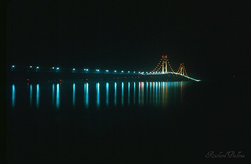
Mackinac Bridge…..I-75, photo by bitsorf.
In this week’s Traverse City Area Chamber of Commerce e-News, Laura Oblinger wrote :
In 1957, the Mackinac Bridge connected the state to new economic and social opportunities. More than a half-century later, high-speed Internet service (broadband) can have a similar impact by connecting all regional businesses to the global marketplace. Statewide broadband deployment is projected to result in a $400 billion increase in the state’s gross state product over 10 years.
If tourists can remain connected to their work, it could mean an additional $52 million to the Traverse City area economy due to stays being extended by just two days.
You can check out the Chamber’s Regional Broadband Initiative page and learn a lot more about Michigan’s Broadband Initiatives and even check connectivity across the state through Connect Michigan.
Check this out bigger!
Much more about the Mighty Mackinac Bridge from Michigan in Pictures!

_______, photo by ryan sandoval.
Taken with Minolta Autopak 600x.
Check it out background boomtacular and in Ryan’s slideshow.

Yellow Dog, photo by Luminous Light Huntress
Stand for the Land is asking folks to show up at the State Capitol this Thursday (June 3) at 11:30 AM for a peaceful rally as they deliver a petition to the Natural Resources Commission regarding Michigan’s first permitted sulfide mine. The event features speakers and Michigan musicians and you can get all the details on Facebook.
The mine is located on the Yellow Dog Plains north of Marquette, where this lovely little river flows. Acid mine drainage from sulfide mines has killed many of the rivers in the west, and there has yet to be a sulfide mine that hasn’t created acid mine drainage.
Have a look at what acid mining has done to Sudbury, and then see if the “jobs” argument holds water when you put the 100 or so mine jobs in one hand and Michigan’s countless tourism industry jobs in the other.
The Yellow Dog Watershed has this to say about the river & watershed:
The Yellow Dog River Watershed lies in eastern Baraga and western Marquette Counties in the Upper Peninsula of Michigan. The area is known as the Huron Peninsula and is one of the last wild areas in the state. The river begins in the McCormick Wilderness Area as an outflow of Bulldog Lake. It then runs 52 miles and drops 1096 feet at an average rate of 1:150ft through granite gorges, open plains, and hemlock forests to end in Lake Independence. From there, another outflow, the Iron River, runs from Independence to Lake Superior. The Iron River was historically part of the Yellow Dog River but had its name changed once industry came to the area.
The watershed encompasses 98 square miles and drains over six smaller subwatersheds. The Lost, Bob, Bushey, Big Pup, and Little Pup creeks all flow into the Yellow Dog River. Waterfalls abound along the Yellow Dog and its tributaries. The terrain is very hilly (some flatlanders might even say mountainous) with high ridges and low valleys giving a spectacular view. The highest point in the watershed is over 1600 ft. Not only can you see the river and forests from the hilltops but also Lake Superior. Wetlands abound and the forest type varies from old growth pine groves to aspen regeneration to stands of hardwood/conifer mix.
Be sure to check this out bigger.

Silver Lake Dunes State Park, photo by Dale Fisher, US Army Corps of Engineers
Unlike the Sleeping Bear Dunes, the Silver Lake Sand Dunes allow private motorized vehicles. The Think Dunes area info site says that in fact, they’re the only dunes East of Utah that allow you to drive a private motorized vehicle (April 1st through October 31st). There are fees and restrictions that you’ll probably want to read about. You can also have Mac Woods Dune Rides drive you through the dunes! Driving not your cup of tea? Fear not – in the middle of the Silver Lake State Park there is a non-vehicle area they call the Walking Dunes.
The State of Michigan’s Dunes Information Page says that the Silver Lake Dunes are a type known as:
Parallel dunes are series of low, linear dunes formed parallel to the shores of large shallow bays. The parallel dunes along the eastern shore of Lake Michigan were formed about 4,000 years ago during the Lake Nipissing stage of Lake Michigan, when water levels were 25 to 30 feet higher than present day Lake Michigan water levels. Rivers entering the bays carried abundant sand, which was then moved along the shore by lake currents.
On shore winds formed these sands into low lying dunes. As the water level of ancient Lake Nipissing dropped, a series of parallel dunes were created. They occurred in areas that were formerly wide bays in Lake Nipissing.
Today, some examples of parallel dune complexes can be seen at the mouth of rivers, including the Muskegon, Kalamazoo, and Grand. Remnants of several ancient bays now are coastal lakes, such as Hamlin Lake in Mason County, Silver Lake in Oceana County, and White Lake in Muskegon County.
Check the photo above out bigger. Dale also had this great shot of the Sliver Lake Dunes from high above Lake Michigan.
More about Michigan dunes on Michigan in Pictures!

