
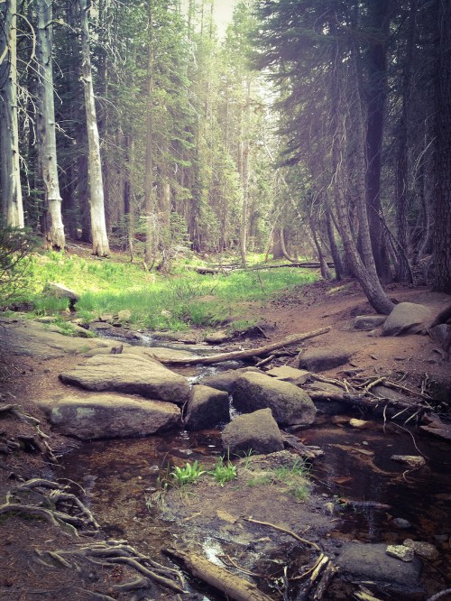
Untitled, photo by Amy Holley
Hope your May brings you promise and new growth.
Amy took this photo on May 1st last year. View it background big and see more wide-ranging goodness in her Outdoors slideshow.
Untitled, photo by Amy Holley
Hope your May brings you promise and new growth.
Amy took this photo on May 1st last year. View it background big and see more wide-ranging goodness in her Outdoors slideshow.

Tulips, Tulips, Tulips, photo by Dawn Williams
Holland’s annual Tulip Time starts this Saturday (May 2) and continues through May 9th. The annual celebration features parades, music, displays of Dutch Heritage and of course tulips, 4.5 million of them!
Dawn took this photo last year. See it background bigtacular on Flickr and check out more of her Tulip Time photos.
More tulips & Tulip Time and more spring wallpaper on Michigan in Pictures.

Ice bound, Whitefish Bay, photo by Thom Skelding
Here’s a cool shot from last Saturday on Lake Superior’s Whitefish Bay. I hope that you’re shaking off the ice and getting out to enjoy whatever spring is serving up close to you.
View Thom’s photo background big and see more great shots from Whitefish Bay and elsewhere in his slideshow.

Osprey Building a Nest, photo by Rodney Campbell
All About Birds from the Cornell Lab of Ornithology is the internet’s best resource for bird information. Their entry for Osprey (Pandion haliaetus) says that osprey are one of the largest birds of prey in North America and one of the most widespread birds in the world, found on all continents except Antarctica. More about osprey at Wikipedia and at Pandion haliaetus (Osprey) from the UM Animal Diversity web.
The Michigan DNR’s Osprey page begins:
The “fish hawk” is brown above and white below, and files with a distinct bend in its wing at the “wrist.” Their feet are equipped with spiny scales and long talons that give them a firm grip on slippery fish, their only prey. Ospreys usually select tall trees in marshes along streams, lakes or man made floodings. They will adapt to artificial nesting platforms. This “help” from humans, along with the restriction of certain harmful pesticides, has helped ospreys recover from the drastic population reductions seen in the 1950s and ’60s. The Nongame Wildlife Fund located 166 pairs in 1988, up from the 81 counted in 1975.
They ask for help in reporting osprey sightings in southern Michigan. Also check out Osprey Watch of Southeast Michigan.
Rodney took this photo of an osprey building its nest in Milford.
MichiganOsprey.com is a great local resource and adds:
Like Bald Eagles, Ospreys often reuse old nests, adding new material to them each season. Ospreys prefer nests near water, especially in large trees, but will also nest on artificial platforms. Ospreys three years or older usually mate for life, and their spring courtship begins a five-month period when they raise their young.
View it background bigtacular and see more in his Birds slideshow.
Michigan in Pictures has lots more Michigan Bird photos!!
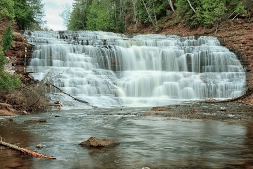
Agate Falls, Bruce Crossing, MI, April, 2010, photo by Norm Powell
GoWaterfalling.com is the site for Michigan waterfalls. Their page on Agate Falls says that this pretty waterfall is relatively easy to get to and adds:
Agate Falls is a Michigan State Scenic Site 6.5 miles east of Bruce Crossing on MI-28. There is a roadside park (Joseph F. Oravec roadside park) just past the bridge over the Ontonagon River. Unfortunately the provided trails and overlooks are somewhat limited. With some effort you can scramble down to the river to get some very good views of the falls, which seems to be popular with local fishermen, or scramble up the river banks to get to the old railroad bridge over the falls. The bridge is now part of a snowmobile trail.
Bond Falls is just around the corner. From Agate Falls, go east on MI-28 and take a right onto Agate road.O Kun de Kun Falls is 8 miles to the north. Go west on MI-28 and turn north on to US-45.
View Norm’s photo bigger and see more (including Bond Falls and other waterfalls) in his great Michigan Upper Peninsula – April 2010 slideshow.
Many more Michigan waterfalls and also more about the Ontonagon River on Michigan in Pictures!
Port Crescent State Park, Michigan, photo by Zack Schindler
The Michigan DNR says that Port Crescent State Park:
…is located at the tip of Michigan’s “thumb” along three miles of sandy shoreline of Lake Huron’s Saginaw Bay. Some of the modern campsites offer a waterfront view, either of the Bay or the Old Pinnebog River channel. Port Crescent recently added a new camper cabin which sleeps six and has a scenic view of Saginaw Bay. A wooden boardwalk parallels the day-use shoreline offering many scenic vistas of Saginaw Bay. The park also offers excellent fishing, canoeing, hiking, cross-country skiing, birding, and hunting opportunities.
And see the map and book campsites here.
View Zack’s photo background bigtacular and see more in his Fuji X-series slideshow.
More state parks and more incredible Michigan wallpaper on Michigan in Pictures.
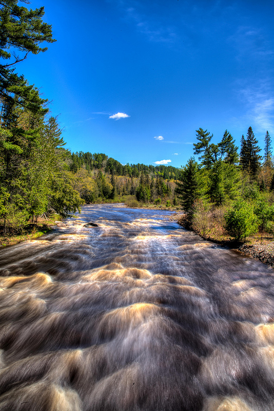
Sturgeon River, photo by Sven
While the ice has melted, leaving the shorelines temporarily free of peril – at least until until bodysurfing season starts – we can take a moment to worry about quicksand. Quicksand in Michigan Streams from Fichigan says:
Everything I know about quicksand I learned from Tarzan movies. The main thing to know is: bad guys don’t make it out, but good guys and gals always do. If you’re a bad guy, please stop reading. Quicksand on a trout stream is a little different than sand bogs in Africa, but there’s some similarity. They are both camouflaged so you don’t see it until it’s too late and if you make it out alive you’ll have an interesting story to tell even if no one believes you.
Quicksand on a trout stream is harder to see since it’s underwater. The stream bottom appears normal except there is no visible hole (sand covers it) so you don’t know it’s here until you start sinking. In waders it’s pretty scary since swimming doesn’t feel like an option.
I’ve found quicksand on the Pine River in Lake County and the Sturgeon River in the Pigeon River State Game Area. On the Pine, the particular spot I know of is a few bends downstream from Raymond Road. The first time I ran into it I was alone. I scrambled to get out and it was like running in place up a sand dune. It was easy to see the exact spot afterwards because a cloud of light gray silt poured out like smoke. An hour later, walking the bank downstream, the silt was still pouring out.
Read on for lots more including his encounter on the Sturgeon River.
I can find photos of almost anything View Sven’s photo bigger on Flickr and see more in his UP Michigan slideshow.
The Sturgeon River is one of Michigan’s Wild & Scenic Rivers – more Sturgeon River on Michigan in Pictures.

Follow the Rainbow, photo by Matt
View Matt’s photo background bigtacular and see more in his slideshow.

Stannard Rock Lighthouse, photo by Michigan Tech University College of Engineering
I came across this stunning video overflight of Stannard Rock Lighthouse last month and discovered a lighthouse I wasn’t familiar with.
Stannard Rock Lighthouse at Lighthouse Friends says (in part):
Stannard Rock, a substantial reef barely covered by the waters of Lake Superior, was named for its discoverer, Captain Charles C. Stannard of the American Fur Company, who charted the hazard in 1835. Because of its remoteness – the nearest land is twenty-five miles away, and the harbor at Marquette is distant forty-five miles – the lighthouse atop the reef has been called “the loneliest spot in the United States” and “the loneliest lighthouse in the world.”
The first plan to mark the reef came in 1849, when $1,000 was appropriated for “a floating bell at Stannard rock,” but as this amount was insufficient to moor a vessel with a bell there, it appears the effort was abandoned. In 1866, the Lighthouse Board determined the time had come to mark the nearly hidden menace to navigation:
Stannard’s rock, lying about twenty-three miles southeast of Manitou Island light, is the most serious danger to navigation in Lake Superior. This shoal is about three-fourths of a mile in extent; it rises two and a half to three feet above the water, and is fifteen or twenty feet in diameter. Its exact locality is known to but few; being so far from land it is seldom seen, and is much dreaded by all navigators. The increasing commerce of the lakes will, at no distant day, demand that it be marked by a light-house, the construction of which will, from the circumstances of its location, be a serious engineering difficulty. As a preliminary to this, and to render navigators familiar with its location, the board recommend that it be marked by a day-beacon, to be composed of a single wrought-iron shaft, not less than one foot in diameter, surmounted by a cage that would be visible not less than five or six miles.
…Stannard Rock Lighthouse stands seventy-eight feet tall and exhibits its light at a height of 102 feet above Lake Superior. The tower tapers from a diameter of twenty-nine feet at the pier to just under eighteen feet at the lantern room, while the seven floors inside the tower all have a diameter of fourteen feet.
Read on for a whole lot more about the history of this now abandoned light, including photos.
The photo comes from the Michigan Tech College of Engineering, part of the documentation of their Ecology of Lake Superior aboard the EPA Research Vessel Lake Guardian presentation. It’s pretty cool and I definitely recommend clicking through to see more photos & video and read about their mission.
View the pic big as Lake Superior and see more in their Lake Superior on board the RV Lake Guardian slideshow.
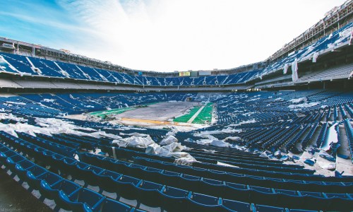
Pontiac Silverdome, photo by Mathew Davey
With the departure of some key players including Ndamukong Suh, Nick Fairley and Reggie Bush and addition of new faces including Ravens stalwart Haloti Ngata, the Lions have had a fairly eventful offseason. One place that not much is happening is the Lions’ former home, the massive and now domeless Pontiac Silverdome.
Stadiums of Pro Football’s page on the Pontiac Silverdome says that this modern-day ruin was designed by O’Dell/Hewlett & Luckenbach and built at a cost of $55 million:
Home of the Detroit Lions for more than 25 years, the Silverdome was one of the largest stadiums in the NFL. Prior to moving into the Silverdome, the Detroit Lions had played at Tiger Stadium since 1938, that was also the home of the Detroit Tigers (MLB). Tiger Stadium was primarily a baseball stadium, but served as the home to the Lions for more than 30 years. In the late 1960s, the team wanted a new football only stadium. After several bonds were passed allowing the team to build a stadium, the Lions bought land in nearby Pontiac, MI. Because of the area’s cold winter weather, the team decided to build a domed stadium. Construction on the stadium, named the Pontiac Silverdome, began on September 19, 1973 and was completed in 23 months.
Opening day for the Lions at the Silverdome was on October 6, 1975. The Silverdome became the largest stadium in the NFL with a capacity of 80,311. Three tiers of blue seats circled the entire Astroturf playing field. The roof at the Silverdome consisted of Teflon-coated fiberglass panels. In 1985 after a heavy snowstorm the roof was structurally damaged. However over the next several months a new canvas and steel-girder reinforced roof was added to prevent the problem from occurring again. The Silverdome had several amenities that included 93 executive suites and a club restaurant. Other than hosting football games, the Silverdome hosted many other events including tractor pulls, soccer and basketball games, and concerts. The first Super Bowl played in a northern city, Super Bowl XVI between the Cincinnati Bengals and San Francisco 49ers, was played at the Silverdome. In the mid 1990s, the Lions became dissatisfied with the Silverdome. By 1997, bonds were passed allowing construction of a new domed stadium in downtown Detroit. The Lions played their final game at the Silverdome on January 6, 2002. The team moved into Ford Field in August 2002.
The Oakland Press has 89 historical photos of the Silverdome including a couple with Barry Sanders. If you want to go get all depressed instead, head over to Curbed Detroit for the saga of the godawful mess the Silverdome has become.
Matthew took this photo in December of 2014. Click to view it big as the Silverdome!
More Detroit Lions on Michigan in Pictures.
