Colors of Crisp Point

colors-of-crisp-point-lighthouse

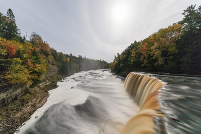
Colors of Crisp Point, photo by John Rothwell

Terry Pepper’s Seeing the Light says that Crisp Point Lighthouse is located on the Lake Superior coastline between Whitefish Point and Grand Island. It’s one of the most beautiful stretches of shoreline in all of the Midwest and:

It is difficult to imagine that during the 1800’s this stretch of seemingly bucolic coastline was known to mariners as “The Shipwreck Coast,” with the hulks of innumerable vessels pushed onto the shore by violent storms out of the north, or lost in the pea soup fogs which frequently enveloped the area.

Since the early 1850’s, the Lighthouse Board had been working on establishing a series of Lights to guide mariners along this treacherous stretch, with Lights established at Whitefish Point in 1848, Grand Island in 1867, Big Sable Point in 1874 and Grand Marais in 1895. As further witness to the dangers represented by this stretch of coastline, Congress approved the establishment of four life saving stations between Vermilion and Deer Park on June 20, 1874, one of which was designated as Station Ten, and built at an unnamed point approximately fifteen miles west of Whitefish Point. Although David Grummond was appointed as the first keeper at life saving station 10, it would be Christopher Crisp who served as keeper from 1878 until 1890 who would have the most lasting impact on the area, as Crisp became so well known that the point on which the station was established would become forever known as “Crisp’s Point.”

…The station was officially decommissioned in 1994, and without keepers maintaining the protective piers, shoreline erosion had progressed to the point that the lake was lapping at the very base of the tower itself. After the brick service room collapsed in November 1996, the GSA feared that the tower itself was in danger of toppling, and not wishing the responsibility and cost of stabilizing or demolishing the tower, the property was scheduled for auction in 1997.

Ohio visitors Don and Nellie Ross came across the old station, and taken with the natural beauty and history of the location, partnered with a number of area residents to form the Crisp Point Lighthouse Preservation Society, with their charter being the restoration and long term survival of what was left of the station.

Read on for lots more and historical photos. Terry adds that a visit to Crisp Point is a “must” for any lighthouse fans, as it remains one of the most desolate and beautiful locations in all of the Great Lakes. More about the lighthouse and its preservation at crisppointlighthouse.org.

View John’s photo background bigtacular and see more in his slideshow.

More lighthouses on Michigan in Pictures!

High Noon: 1909: Marquette Main Street via Shorpy

Marquette Front Street

Marquette Front Street c 1909, photo by Lycurgus S. Glover (Detroit Publishing Co)

The Shorpy Photo Archive is a magical website that has been around for years, dishing up incredible and well presented public domain photos from around the country. Many, like this one of Main Street in Marquette from 1909, are from Michigan. In addition to a link to purchase a print of the photo, all include a giant view of the image and a discussion board that uncovers many of the details that become apparent when you look at the picture closely such as this odd detail in the lower right:

“Why is there a wooden platform behind him leading to a blank wall?”

The wooden platform is actually a bridge over a set of railroad tracks that lead out to cranes for unloading coal in the Marquette Harbor. The wall is for safety as it was a 16′ drop down to the tracks. See attached links for different view of Front Street and the City of Marquette around that time. You can see the same wood bridge in one and the cranes in the other. Also you can see the ore docks that gravity load iron ore into ore boats to take the iron ore to Pittsburgh. Iron mining was and still is a big business in Marquette County. The photo in question was taken standing on the a steel bridge leading to the old ore dock that can be seen in the attached photos.

Click through to check the photo out background bigtacular. As one commenter notes, “It’s noon by the building clock, and the locals are mobbing the ice cream parlor.”

Looking up at Detroit’s One Woodward Avenue

one-woodward-detroit-michigan

One Woodward, Detroit MI, photo by sbmeaper1

Denise McGeen’s article on One Woodward Avenue at HistoricDetroit.org says (in part):

At the heart of Detroit’s Civic Center, towering over Hart Plaza, Woodward Avenue and the Detroit River stands One Woodward, one of Detroit’s most celebrated mid-century modern structures.

The building was commissioned in 1958 by the Michigan Consolidated Gas Company Building. Detroit architect Minoru Yamasaki designed the skyscraper in association with the firm Smith, Hinchman & Grylls. The building would open in 1963 and marked a first for Yamasaki, who had never designed a skyscraper before. The building incorporates a pre-cast concrete exterior, narrow windows, Gothic arches, decorative tracery and sculptural gardens that later became the architect’s signature motifs. It has been called the fore-runner to Yamasaki’s renowned World Trade Center in New York.

…The tower’s all-welded, steel frame is clad with two-story, pre-cast concrete panels that hold 4,800 vertical hexagon-shaped floor-to-ceiling windows. The panels hang above the exterior terrace as if dripping from the building’s frame. Hexagonal grillwork wraps the building’s top two stories. The roofline features delicate crenellation — an architectural feature similar to a castle’s battlements.

Read on for much more including the challenges this project posed for Yamasaki as his first project.

View sbmeaper1’s photo big as a skyscraper and see more in their slideshow.

More architecture on Michigan in Pictures.

Moonglow at Tahquamenon Falls

moonglow-y-rudy-malmquist

Moonglow, photo by Rudy Malmquist

Gorgeous photo from after dark at Tahquamenon Falls State Park.

View Rudy’s photo background bigtacular and see more in his slideshow.

Lots more about Tahquamenon Falls on Michigan in Pictures.

Friday Fall Color Update from the High Rollways


high-roll-away-buckley-michigan

High Roll Away, photo by Charles Bonham

“Of all the places I’ve worked here in Michigan, this is my favorite place to collect my senses, do a little meditating and get rid of my problems. It’s like a soothing balm.”
-Ray Westbrook, retired DNR on the High Roll-Away

Charles took this yesterday at the Buckley High Roll-Away overlooking the Manistee River, and it shows how autumn color continues to lag a bit behind in northern lower Michigan. mLive posted some satellite pics of fall color from NASA’s Aqua satellite earlier this week that give you a look at how things are shaping up. If you’re thinking about a jaunt, Pure Michigan’s fall color tours provide some pre-planned ideas all over the state. To get current fall color, I usually find it best to pick your location and call their chamber or visitor’s bureau. The bigger ones in Traverse City, Petoskey, Marquette, Grand Rapids, and elsewhere will often have a good idea about a large range.

MyNorth’s Jeff Smith has a great story on Buckley’s Big View that says in part:

Like any notable landmark without an official name, this one goes by several aliases—Horseshoe Bend Overlook, Lookout Point or the Highbanks Overlook—not to mention spelling variations. Depends who you ask.

Stand atop the Roll-Away and the scenery is for certain. From the lookout it’s 200 feet down, and before you the valley curls up like a vast bowl, taking in a viewscape of almost 130 square miles of dense pine and hardwood forest. The bowl’s rim, a ridge, runs roughly from Manton in the east, around to Meauwataka and Harrietta in the south (you’ll see the distant radio towers), and on the west to Mesick.

Here, more than a century ago, the expanse of treetops inspired awe among those who saw wealth in the more than 1.2 billion board feet of lumber in the upper Manistee River basin. Surveying the area in 1869 for the Manistee River Improvement Company, A.S. Wordsworth wrote, “This river is the great highway that penetrates the vast pine region of Manistee. … It is without doubt the best logging stream in the world, and all along its circuitous path, reaching far away, it seems to bear mute testimony to the wonderful wisdom of the Creator.”

Read on for lots more and here’s the map on Waymarking!

You can get Charles’ photo background bigtacular and see more in his slideshow.

Lots more fall color and fall wallpaper on Michigan in Pictures!


Find Your Wayve

find-your-wayve

Find Your Wayve, photo by Noah Sorensen

View Noah’s photo from Elberta Beach on Lake Michigan background bigtacular and see lots more from Noah on Flickr.

More fall wallpaper on Michigan in Pictures.

Photo-op gone bad

photo-op-gone-bad

Photo-op gone bad, photo by Paul Wojtkowski

Paul got caught by an unexpectedly large wave on Lake Superior – good thing he had already taken his selfie-stick shots!! :D

View his photo big as the biggest lake, see more including Manabezho Falls in his slideshow, and view and purchase photos on the-woj.com.

On a more serious note, as yesterday and today’s posts show, these big lakes have big and sometimes unexpected power, particularly as we head into fall and winter. Take a moment to see what’s going on, watch for a minute so you know what’s going on, be sure of your footing, and take a buddy or two if you can!

Soaring Saturday: Hang Gliding in Michigan

coming-in-by-david-clark

Coming In, photo by David Clark

USA Today has a feature on Hang Gliding Sites in Michigan that says (in part):

Most individuals will need lessons in hang gliding from a certified instructor prior to their first flight. Hang gliding schools provide instructions, gear, permits and safety equipment. The Draachen Fliegen Soaring Club is located in Cloud 9 Field between Detroit and Lansing, with instructors offering “tandem discovery” flights lasting from 15 minutes to one hour. Gliders drift in air space up to two miles high, in tandem with an instructor. Individuals with proven experience and certifications may rent gliders for solo flights. Traverse City Hang Gliders offers full programs of training and instruction in both traditional powerless hang gliding and “the Mosquito” powered hang gliding harness.

Hang gliding enthusiasts can enjoy practicing the sport at national parks within the state of Michigan, including Sleeping Bear Bear Dunes National Lakeshore. Several spots within the park are approved for powerless flight. Hang gliders can take off and land at Empire Bluff, Pyramid Point and Lake Michigan Overlook on the Pierce Stocking Scenic Drive, as well as Dune Climb in the months of November through March. Powerless flight permits are required and can be obtained free of charge at the Visitor Center Information Desk. Launch sites within the park require proficiency ratings established by the U.S. Hang Gliding Association. Gliders must also follow safety and federal regulations. Warren Dunes State Park also issues permits for hang gliding along the coastal dunes, about 14 miles from the state border with Indiana. Favorite launch and return sites within the park include Tower Hill and New Buffalo.

In the 1970s, Elberta Beach and the adjacent city of Frankfort, in Northern Michigan, were popular spots for what was then the new sport of hang gliding. Once referred to as the “Sail Plane Capital,” the area is still a magnet for gliders today. Just south of Frankfort, gliders can experience the thrill of soaring over sand dunes at Green Point Dunes. The Green Point Flyers Association, established in 1978, is a club for both hang gliders and parasailers, with a main flying site that is a sand dune stretching for three miles at a height of 370 feet. Licenses are required to fly at Green Point, and certified instructors are available. Pilots at Green Point also have access to hang gliding sites inside the Sleeping Bear Dunes National Lakeshore, as well as the bluffs of Elberta. Visitors can also team up for a ride with members of the Northwest Soaring Club, which is located in Cadillac, Michigan. Flights depart from the Wexford County Airport, then cruise over Lake Mitchell and Lake Cadillac.

View David’s photo background bigilicious, see more in his Turning 42 slideshow, and view and purchase work at leelanauphotography.com!

If you’d like to get a look at the process, here’s a video of aerial photographer Jim Anderson taking a flight from the Bluffs!

Tom Izzo: Definitely One of the Most Famous Natives of Michigan

tom-izzo-michigan-state-spartans

Tom Izzo, photo by Hillary Higgens

TRUE CONFESSION: Page-at-a-time slideshows make me want to smash my screen, but I have to say that what mLive is doing with slideshows has been pretty cool. Their feature on the Most Famous Natives of Michigan has their pick for the most famous person from each of Michigan’s 83 counties. Definitely worth a read. Share your thoughts here on on the Michigan in Pictures Facebook!

It’s hard to argue with their choice for the most famous person from Dickinson County, Michigan – Michigan State University Spartan coach Tom Izzo:

Since 1995, Tom Izzo has led the Michigan State men’s basketball team as head coach. Born Jan. 30, 1955, Izzo was recently inducted into the Naismith Memorial Basketball Hall of Fame. Under his watch, the Spartan team has made it to the Final Four seven times and taken home an NCAA Men’s Division I Championship.

Hillary took this photo back in 2011. View it background big and see more in her 2011 Champion’s Class slideshow.

Wild & Scenic Rivers: September color along the Carp River

big-carp-river-in-september-fall-color

West from the Lake of the Clouds, photo by Jim Sorbie

Glints of yellow, orange and red are starting to pop up around the state, so it’s probably time to get some fall wallpaper for your computer! Check that link for a ton and get fall color reports and color touring ideas from the Pure Michigan Fall Color page!

It’s also been a while since I added a Michigan Wild & Scenic River to the blog, so here’s the somewhat brief entry for the Carp River from the National Wild & Scenic Rivers:

The Carp River, in Michigan’s Upper Peninsula, flows through predominantly forested lands with little development along its way. Spring’s high water provides for canoeing and offers steelhead fishing and dipping for smelt near the river’s mouth. Summer is the time for brook or brown trout, and fall brings salmon fishing. The Carp is known for its outstanding recreation, wildlife, geologic, ecological, fisheries and heritage resource values. The river flows through the Mackinac Wilderness Area.

Michigan has 16 nationally designated Wild & Scenic Rivers – get them all at that link!

View Jim’s photo background bigtacular and see more in his Color Tour 2014 – UP & Canada slideshow.