Placidity

Placidity

Placidity, photo by SpringChick.

SpringChick writes:

pla*cid”i*ty (n): 1: a feeling of calmness; a quiet and undisturbed feeling.A thin blue line marks the horizon in a tranquil sea of blue; Lake Superior at Superior Point near the Wisconsin/Michigan border.

Here’s hoping your weekend has all the placidity you need!

Pictured Rocks3

Pictured Rocks3

Pictured Rocks3, photo by Devo(lutio)n.

Here’s a beautiful photo of the Pictured Rocks National Lakeshore by Devon Akmon. Devon was one of a number of photographers who were kind enough to let us use their photos on our Destination: Michigan tour of the Pictured Rocks National Lakeshore on Absolute Michigan. It’s the first of what we hope will be a whole lot of profiles of great places to visit in Michigan that we’ll be publishing at Destination: Michigan!

You may want to compare this photo with a shot taken from the same spot in the winter and/or check out Devon’s other photos of the Pictured Rocks.

Biplane over the Bridge

Untitled, photo by prakope.

This is one of a great set of photos that offers a unique perspective on the Mackinac Bridge. I had a hard time choosing which one to post and I think you’ll probably enjoy the slideshow. If you’re too busy for that, be sure to at least check out this view of the massive concrete supports.

If you’re interested in flying the skies over the Mighty Mac, Mackinac Island and the Straits, check out Carolina Barnstormers.

Huron Island Lighthouse

Huron Island Lighthouse

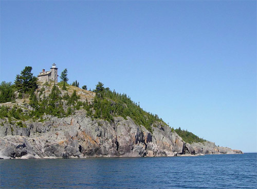
Huron Island Lighthouse, photo by Clyde Elmblad

The Huron Island Lighthouse, constructed in 1868, still stands today atop Huron Island, the second largest island of the Huron Islands chain in southern Lake Superior. The lighthouse was built to guide vessel traffic between Marquette and Pequaming, and between the L’Anse/Baraga and Houghton/Hancock ports via the Portage entry in the state of Michigan.

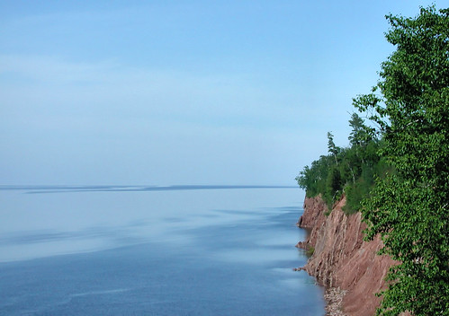
The lighthouse is approximately three miles north of Huron Point and the Huron Mountains, some twenty miles east of the Keweenaw Peninsula. Graced by regional history and natural beauty, the Huron Island Lighthouse has long been considered a local historic treasure.

More photos (including historical pics) and tons more information about the lighthouse and the island chain can be found at the Huron Island Lighthouse web site. Apparently their web site has vanished – I would appreciate a link if anyone knows it!

Apparently, the Huron Islands area is a great shipwreck dive site as well. This page about the Marquette Underwater Preserve says:

The Huron Islands Unit encompasses some of the most impressive coastline in the state. The shore ranges from sandy beaches to towering cliffs, backed by the scenic Huron Mountains. Much of the diving is done in the clear waters surrounding the Huron Islands, a group of rugged granite knobs rising out of Superior’s depths.

You can get maps and detailed information about diving the area at the Michigan Underwater Preserve Council’s page for the Marquette Underwater Preserve.

Sunset Slacklining

Competing knighting
Competing knighting, photo by xhavier

Sometimes when I dig around for photos, I find other pictures that are totally unrelated to what I am digging for but very cool nonetheless … I think this is one of those cases. The photo was taken at Sherman Park in Sault Ste. Marie, which is apparently a hotbed of slacklining in Michigan.

For more about what looks to be an interesting and challenging pursuit, check out the slacklining photo pool on Flickr, the Slackining entry on Wikipedia and Slacklining information by outdoor photographer Eric Matthes, who writes:

Slacklining began when climbers hanging out in campgrounds became bored and started playing with their equipment. Slacklining develops balance which is helpful in climbing, but that is not the only reason people do it. Far more important is the feeling you get when you experience that moment of perfect balance, when your mind and body are absolutely motionless over the line and all is right in the world.

Relaxation

Relaxation

Relaxation, photo by Greg_Smith.

Lane Cove, Isle Royale National Park

Herbert C. Jackson

Herbert C. Jackson

Herbert C. Jackson, photo by Jowo

Joel Dinda tells stories about the past and present with his photos and also with the words he writes about them. Some, like the above pictures of a freighter in Sault Ste. Marie or Borucki's Lakers, are about Michigan. Others, such as Life Along the Rail and Thursdays: Vietnam 1971 cross state and national borders.

Take a look, I have no doubt you'll find something interesting.

This photo is part of a set that lends itself well to Flickr's slideshow feature.

Summer Fields

Summer Fields by Mark Cassino

Summer Fields, photo by Mark Cassino

KalamazooPhotographer Mark Cassino says that after driving past this farm and field of wildflowers for a few days, he finally pulled over and snapped a couple of frames before leaving. This photo is part of Mark's Five Nights in Skanee gallery.

Skanee is located on Lake Superior's Huron Bay, just a bit east of L'Anse.

skeleton

skeleton

skeleton, photo by We Are CS.

One of a great set of photos of Upper Peninsula Mining Ruins.

Cyanotype 03 (Cut River Bridge)

Cyanotype 03

Cyanotype 03, photo by DoBSoN 77.

This photo is one of a series of cyanotypes of the Cut River Bridge and other subjects. You have to go see it because there's a VanDyke in there of the understructure that is amazing.
The bridge is located on US-2 and if you have a few extra minutes, be sure to stop and check out the stairs or trail to explore a little. It's really an amazing structure.

According to this letterboxing site:

Cut River Bridge is located in Michigan's Upper Peninsula along US-2 between the towns of Epoufette and Brevort. It's about 25 miles northwest of St. Ignace and the Straits of Mackinac.

The locals call Cut River Bridge "the million dollar bridge over a two-bit creek." Cut River Bridge is a cantilevered steel deck bridge, built in 1946. It spans the tiny Cut River, a surprising 147 feet below. From either end of the bridge, you can descend a short ways and view the immense steel structure that supports the road.