Fall Color Tours: Marquette, Negaunee, Au Train

The Start of Autumn by Marjorie Obrien

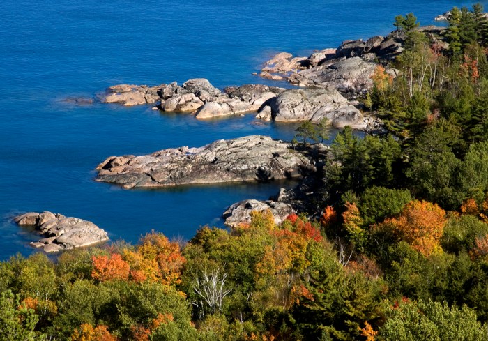
The start of Autumn, photo by I am Jacques Strappe

You can get 100+ more photos of the Upper Peninsula in autumn from Marjorie (slideshow).

Last fall through Absolute Michigan/Michigan in Pictures we started using the great information compiled in Travel Michigan’s Fall Color Tours as a starting point to point you to some great fall color touring (and fall color photos) around the state.  We’re trying to add to what they’ve put together – not rip them off! As always, if you have links to information or photos that we missed, comments or reports, post them in the comments below!

We’ll start with a driving tour of the Central Upper Peninsula that’s best from mid-September to early October and about 185 miles long. The tour starts in the UP’s largest city, Marquette. Marquette features some amazing architecture. You can read about and see pictures of it courtesy of Marjorie’s blog, Michigan Architecture, especially the beautiful red sandstone.

I recommend wandering around downtown for a while to check out the buildings and maybe grab a muffin from Babycakes and some coffee at Dead River Coffee. Travel Michigan (TM) recommends a visit the Marquette Harbor Lighthouse, home of the Marquette Maritime Museum. The lighthouse (pictured right by n. weaver, part of his UP slideshow) was constructed in 1866 and is the oldest significant structure in the city and more importantly, the lighthouse is one of the most historic navigation beacons on Lake Superior. There’s a nice little park behind it where you can swim if you are totally insensitive to temperature.

TM suggests that Presque Isle Park is also worth a visit and it is, offering a slow, brief jaunt along the rugged Superior shore and lots of nice little trails. It’s also a great bike ride along the shore on an excellent bike path from the lighthouse.

Now’s probably a good time for a map – click TM’s map to see larger. Heading north on County Road 550 to Big Bay takes you on a half hour cruise through some beautiful country rich in trees and views.  You can stop and do the 20 minute or so climb of Sugarloaf Mountain (see some pics from Lake Superior Photo). In Big Bay is the Thunder Bay Inn where you are required by travel writer code to mention  “Anatomy of a Murder” which was filmed there. Unfortunately the Thunder Bay Inn has been shuttered.  You can stop in at some of the other businesses and stay at the Big Bay Point Lighthouse Bed and Breakfast (if you call, they sometimes offer tours).

From Big Bay, head back on County Road 510 through the Huron Mountains and trees that arch over the roadway to form a tunnel of color. At US-41 head right and south into Negaunee (Chippewa word for pioneer) where you can visit the Michigan Iron Industry Museum, site of the first iron forge in the Lake Superior region. Negaunee’s Union Station Depot looks like a neat place to stay.  From Negaunee, continue to Ishpeming, home of the U.S. National Ski & Snowboarding Hall of Fame and the Cliff’s Shaft Mine Museum.

The route takes you down County Road 476 to Palmer and from there on M-35 south to Gwinn. You can enjoy hiking and mountain biking at Anderson Lake West State Forest Campground or continue south on M-35 to Little Lake where you take County Road 456 east to US-41. A left US-41 takes you north to M-94 where you turn right on M-94 to Chatham and can ask “Honey – are you sure we’re not lost?” 3 miles north off M-94 at Sundell are the about 100′ high Laughing Whitefish Falls (photo right by Church of One).

From there it’s east until you reach H-03 located between Chatham and Forest Lake, north on H-03 along the AuTrain River and past AuTrain Lake until you reach the junction of M-28. You can go east 12 miles along the Lake Superior shoreline on 28 to Tyoga Pathway or go west back to Marquette.

Check out more Michigan Fall Color Tours on Michigan in Pictures and also our fall wallpaper collection!

The Wood Turtle in Michigan

Turtle by LuckyGus

Turtle, photo by LuckyGus

Updated September 30, 2008: LuckyGus captured this photo on the Betsie Valley Trail in Benzie County. Below you can read about TurtleGate ’08, which was touched off when I misidentified this turtle as a common snapping turtle. My Ranger Rick Top Terrapin Tagger badge has been repossessed and sources tell me that a number of zoologists are “keeping an eye on me”.

The Michigan DNR’s page on the wood turtle (which should have helped me identify it) says that:

As its scientific name, Glyptemys insculpta, implies, the shell of the wood turtle is one of the most ornate of the turtles in Michigan. A noticeable keel running down the back of the carapace and the pointed edges of the scutes along the back edge add to its sculpted appearance. The yellow on the underparts of its neck, legs, and stomach, plus the highly visible deep circular growth rings of the scutes on the brownish carapace help with identification. The adult carapace length is 6.3 to 9.4 inches (16 to 24 cm)

Wood turtles live in rivers with sandy-bottomed streams and rivers. They spend most of their time in the river from September to May, but in summer can be found foraging in woods, swamps, and meadows in the upland areas edging the stream or river. Logs or banks near water and sunny woodland openings are often utilized for basking.

These turtles are omnivores eating a variety of plants and animals and carrion found in and along the river. Wood turtles employ a unique technique to hunt earthworms. Using either an alternating foot stomp, or by lifting and dropping its shell on the ground, they create vibrations in the ground. These vibrations will cause earthworms to surface where they are quickly snatched for a meal. Anglers seeking bait can employ a similar technique. A stick stuck in the ground and wiggled back and forth to create vibrations will cause earthworms to leave the ground.

Michigan’s wood turtle population has declined in recent years and it’s considered rare in the northern Lower and Upper Peninsulas. More about wood turtles can be found at Wikipedia’s Wood Turtle entry, woodturtle.com and from the MSU Museum’s “critter guy”, James Harding who notes that They may not be taken from the wild or possessed without a scientific collector’s permit issued by the DNR.

You can also check out What’s Up With the Wood Turtle? from MyNorth.com for a look at fieldwork being done in Northern Michigan on the wood turtle.

(from July 2008) TurtleGate Update: A Nation in Slow, but Very Real Peril

I have finally gotten back to this to find out if I am indeed a dirty, no-good turtle mis-indentifying so-and-so or merely guilty of the litany of other things that I may or may not be guilty of per the comments. From the Michigan DNR Turtle page I was able to learn:

  • The eastern box turtle appears to not look like this turtle at all.
  • The wood turtle appears to have a black face, but this photo looks sort of similar.
  • However this snapping turtle’s shell looks very similar.
  • I am forced to conclude that I don’t know the answer.
  • I’ll end with a shout-out to a herpetologist or other expert to set me straight.

The Sleeping Bear Dunes National Lakeshore

Must. Reach. Water.

Must. Reach. Water., photo by J.E.T.

This photo is part of Jesse’s Northern Expedition II set (slideshow) and – for me at least –  does the best job of all the 400+ Sleeping Bear photos that I’ve looked through today in capturing the wonder and wide-open fun of the Sleeping Bear Dunes National Lakeshore.

I’ve been doing that because today on Absolute Michigan I just finished Dig Michigan: Sleeping Bear Dunes. It’s a map, link and photo filled exploration of the national park in my backyard … I hope you like it.

Wonderland

New Years Day

New Years Day, photo by hampsters.

The Detroit News reported that the 16″ snowfall on January was the biggest ever for a New Year’s Day and the fourth-biggest snowfall in southern Michigan history. The biggest southern Michigan snowfall ever was 24.5 inches on April 6, 1886*. Many folks managed to avoid the downsides of power outages and poor driving conditions and got out and enjoyed the conditions.

You can view a slideshow of photos from the storm or just view the thumbnails.

* I searched and searched for the state record – if anyone knows, please post in the comments!

Abbott Road Park … but what about Theophilus Capen Abbot?

Abbot Park

Abbot Park, photo by jstealth03.

Abbot Road Park is one of the City of East Lansing’s 24 neighborhood parks. It’s located north of Lake Lansing Road and designated as a hiking and cross-country ski trails natural area with access to the Northern Tier Trail.

The city can’t seem to settle on a name for the park. Their web page calls it “Abbot Park” but the road is “Abbott Rd”. The city’s park & facilities map (pdf) lists it as “Abbot Road Park” so that’s probably correct. However, there’s the matter of Abbot Hall, about which Kevin Forsyth’s fabulous History of East Lansing says:

The hall was named for Theophilus Capen Abbot (1826-1892). Dr. Abbot joined M.A.C. as Professor of English from 1858 to 1866. He then became acting Secretary of the Board of Agriculture, a position he effectively held until 1871. Concurrently — and most importantly — he was third President of the College from 1862 until 1884. During his long and distinguished tenure, he guided the growth of the school through difficult times, and “showed an eye single to the grand object for which the College was established. Nothing could swerve him from a course which should ever keep in view the aid and promotion of agriculture.”

In any case, I’ve added a marker for Abbott Road Park to our Absolute Michigan map of Michigan and requested some sort of clarification from Mr. Forsyth – if you have anything to add to my confusion or the discussion, please post it in the comments!

Mist Woods and Porcupine Mountains terrain

Mist Woods

Mist Woods, photo by Kim Nixon

Kim says that this photo was taken on the way up the Summit Peak Path in the Porcupine Mountains on October 6th, 2007. She has more photos from (and writing about) the UP on her blog, The Dailies.

SuperiorTrails.com says that the view from Summit Peak is the most “don’t miss” attraction in the park. On their Porcupine Mountains Hiking Trails page, Exploring the North writes:

This trail provides an opportunity to visit Summit Peak at 1,958 feet, the highest point in the park. A 40-ft. observation tower provides an outstanding view of the park as well as the surrounding area . Wisconsin, Minnesota, the Apostle Islands, and Copper Peak are a few of the sights that can be seen on a clear day. A viewing deck on the way up to the summit provides a panorama of the Little Carp River valley and ranks as one of the best views of the park.

Our Absolute Michigan Map of Michigan at Google Maps got a cool upgrade earlier this week with the addition of a new “Terrain” feature, and I thought the Porkies (which probably offer Michigan’s most wild & rugged terrain) would be a perfect place to put the map through its paces – click this link to check it out and let me know what you think!

You can get a detailed trail map at the Porcupine Mountains Wilderness State Park page from the DNR.

Envision Michigan

Deep Thoughts and Work Comps by CAVE CANEM

Deep Thoughts and Work Comps, photo by CAVE CANEM

The Center for Michigan is an organization I work with that I very much admire. They are dedicated to helping to transform Michigan’s business, economic, political and cultural climate. One of their efforts to help us get our arms around what we have and to visualize what we could become is their Envision Michigan Competition.

You can see the weekly winners on their web site like Michigan is richer than we think, It’s all about the water and Walking the trails, in which Norma Wolf writes:

My home is in a wooded subdivision in Haslett, a suburb really, of East Lansing. A daily trek down my tree lined street will take me into the woods on a trail that twists and turns through five miles of beauty. I pass through deciduous trees and pine forest. I travel literally through the wetlands and up and over flowing streams. In the Spring I watch as the skunk cabbage makes its appearance and later I delight in the snake dozing in the sun along my path. In the fall the wind through the leaves of maple and oak remind me of the true beauty of this state of Hiawatha.

Entering your photo, essay or video is easy and you can win a part of $30,000 in prizes including weekly Meijer shopping sprees, college scholarships and Michigan vacations. Check it out.

I picked this photo because the photographer is one of too many talented folks who left our state for economic reasons. It seems clear to me that Michigan can’t afford to continue to allow our best to leave and our brightest bulbs to never shine to their full brightness.

In my opinion, that means that we as a state need to commit our efforts, intellects and hard-earned dollars to rebuilding our state as a place that operates with its eyes wide open to the realities of the modern world. I think that the last decade demonstrates that it’s not enough to talk about our commitment to our children, our future and our state and draft plan after underfunded plan. Sooner or later, you actually have to roll up your sleeves and get to work.

I don’t know what your opinion or vision is, but I do know where you could share it…

raven hill

raven hill

raven hill, photo by Latitude 45.

Every couple of days I look to see what people are looking at on Michigan in Pictures. The Michigan Wallpaper page is always at the top, and you can count on seeing favorites like Slumpy and the Big Boy Graveyard and The Southdown Challenger in there.

And just about every day in the fall – including today – Martin’s Fall Leaves photo is right there, reminding me to go look at his great photos of Petoskey and nearby.

Wisdom of the crowd I guess.

This photo might be from the Raven Hill Discovery Center near East Jordan.

UPDATE: Martin let me know that it’s from the Raven Ridge Nature Preserve of the Little Traverse Conservancy, which was purchased by the Conservancy and the Discovery Center. Click that link to see a cool map (select Raven Ridge) and learn a little more about this and other preserves!

In the Pigeon River State Forest…

2007_0703July40155

2007_0703July40155, photo by JJ Murletti.

I don’t know the name of this lake but was struck by just how peaceful it looks.

There’s a campground in the Pigeon River State Forest and lots and lots of trails. The DNR says that the Pigeon River Pine area has over 100 acres of white pine (most about 100 years old) and that the Dog Lake area is considered to be one of the most remote and wild areas in the region. Nesting loons, bald eagles, and osprey are a few of the many animals using the lakes.

The International Mountain Biking Association is quite taken with:

An awesome ribbon of trail looping through the heart of elk country, the High Country Pathway (HCP) embodies the classic definition of an IMBA Epic Ride. The first IMBA Epic Ride in Michigan will take you far into the backcountry with beautiful lowlands and panoramas in the highlands.

Be sure to outfit for self-support, as you may not see another human on this 80-mile soul searcher. The trail passes through a variety of woodlands and wetlands containing massive groves of silver beech, tamarack swamp and leather leaf bogs. The area is home to beaver, black bear, bobcat, pine martin, snowshoe hare, wood ducks, bald eagles, deer, wild turkey and the largest elk herd east of the Mississippi River.

Kirk Park

Thanksgiving Sunset

Thanksgiving Sunset, photo by wizardkitten.

It’s been 2 weeks since the last Michigan shoreline tour stop at Holland (feels like 2 weeks since I last got on the Michigan shoreline myself!).

While I didn’t find much about the history of Kirk Park at the page Google thinks is best, I did stumble onto this review of the Dune Ridge Trail at Kirk Park from Jim DuFresne’s Best Hikes with Children in Michigan Guide Book (there’s 80 hikes on that page – check it out):

There is a tendency at Kirk Park for children to head straight to the beach. They jump out of the car and hightail it down a paved path to Lake Michigan where they jump into the surf, roll in the sand, or get scorched by the sun. Then their parents take them home, usually waterlogged, sunburnt, and with half a dune in their bathing suits. Should have taken them hiking. At 66 acres and with 2000 feet of lakefront, this Ottawa County park is not large. In fact, it’s basically one dune. But it’s a large dune, and major renovations in the mid-1990s resulted in an intriguing 2-mile trail system over and around this towering hill of sand. The heart of the system is Dune Ridge Trail, a mile-long loop that climbs the hill and then circles the top to reward hikers with excellent views of Lake Michigan.

Cathleen says she likes this park and goes there quite a lot. After seeing her pictures and those from Thomas, Craig (who apparently heeded that “take the trails” advice), Katie, Holly and others, I can see why.

Here’s a Flickr map and also the entry for Kirk Park on our Absolute Michigan map of Michigan.