

Untitled, photo by Brooke Pennington.
The other night I saw the afterglow of the sunset at 7:30. Reminded me that the world keeps tilting and turning along.
Untitled, photo by Brooke Pennington.
The other night I saw the afterglow of the sunset at 7:30. Reminded me that the world keeps tilting and turning along.

P1010050c, photo by Dan & Mary.
The web site for the annual UP 200 / Midnight Run and Jack Pine 30 sled dog races explains that 1988 a group of mushers and others began to discuss a dogsled race in the Upper Peninsula.
When the race finally began to take shape, the trail encompassed Marquette, Alger, and Delta counties, and ran from Marquette to Chatham, Rapid River, Escanaba, Gwinn, and back to Marquette…
…and on a snowy Friday evening in February of 1990, the dedication and perseverance finally paid off. To the cheers of 10,000 spectators, the mushers of the first UP 200 Sled Dog Championship ten dog race sped down Washington street in Marquette into the night. At midnight, in the community of Chatham the first Midnight Run racers departed on the long, cold journey towards Escanaba. These racers went on their way into history, with many “tails of the trails” for the years to come.
The UP200 and Midnight Run have remained successful events each year and they take place this weekend (Feb 15-17) and you can get all the details (including the trail map and Breakaway’s Blog at the link above!
Mary writes that this photo shows a team is approaching the crossing at Forest Highway 13, heading west to the next checkpoint at Munising/Wetmore, MI. It’s part of a set of UP 200 / Midnight Run dogsled races 2007 photos (slideshow)
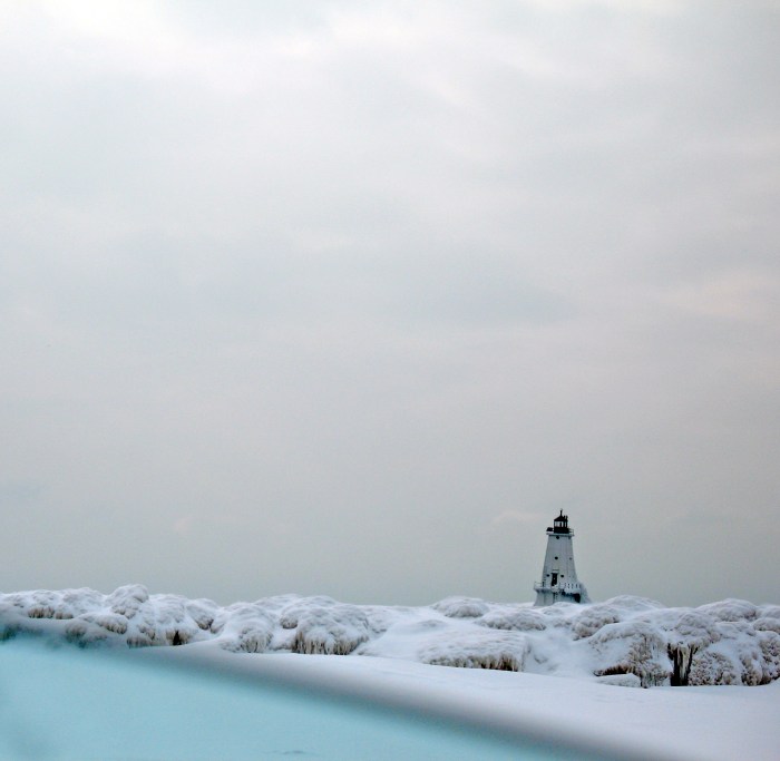
Winter Blues, photo by simply, Diann.
Diann writes What I’m really wondering is whether or not its a good idea to edit out the blue shadows that often show up in winter shots when the sun is behind the camera. She offers this shot for comparison and discussion. She also has a bunch more photos of Ludington’s lighthouse, many in the crashing seas that are referred to below! (and usually uploads her photos at desktop wallpaper size!)
Terry Pepper’s page on the Ludington North Breakwater Light has a really fascinating history of this lighthouse at the mouth of the Pere Marquette river. A lighthouse was established here in 1870 to aid in the navigation of the lumber ships that served the mills of Ludington and Pepper’s article details the trials endured by the keeper after Congress appropriated funds for the light but none for his dwelling (sound familiar?). Pepper goes on to detail the unique structure of the current North Pier Light:
Over the summer of 1924, a unique structure took shape at the end of the North Breakwater. The main tower, fabricated of steel plates over an internal steel skeleton, took the form of a four-sided pyramidal tower with four round porthole windows on each of the three decks within. With plans calling for the installation of an air diaphragm fog signal operated by an electrically powered compressor, there was no need for a large fog signal building, and thus the signal building took the form of a relatively small structure integrated into the base of the landward side of the main tower. In order to help protect the structure from the force of waves crashing across the breakwater, the concrete foundation at the base of the structure was formed with angled surfaces designed to deflect the force of wave action up and away from the building. The white painted tower was capped by a square gallery and an octagonal iron lantern installed at its center.
There’s great historical photos at the link above and if you’re a lighthouse buff, I can’t recommend Terry Pepper’s site enough. His pages on lighthouses of Michigan and the rest of the Great Lakes are the best there is.
Although Wikipedia’s entry on the Ludington Light is downright feeble, it does link to a nice set of videos of the Ludington lighthouse. There’s also this cool video of the lighthouse.
I’ve also added the Ludington Light to Absolute Michigan’s Map of Michigan.

Newspaper did get delivered, photo by wxman1952.
mLive reported that the snowstorm of February 6, 2008 was a whopper, closing over 200 schools in Michigan and dumping up to up to 16 inches of snow fell in the Flint and Saginaw area.
Michael runs the Mid Michigan Weather web site where (among a whole lot of other weather things) you can find a discussion about the impact of the storm all over the state.

thru the woods, photo by litchard.
I’d never heard of the Wing Aero Sleigh – designed & built by Blain Wing in St. Ignace, Michigan in the 1940s – but Milton has a bunch of cool photos of the Aero Sleigh in action (slideshow)
There’s some information about how these were used from the Drummond Island Yacht Haven.
He uploaded the photos pretty large so be sure to click through check them out!

breakwater, photo by Latitude 45.
Martin has three photos of the ice-shrouded Petoskey breakwater. There’s also one photo of how his dog remembers where he left the salmon, but the less said about that, the better.
Grand Island VI, photo by gowaterfalling.com
Waterfalls of the Great Lakes Region and Beyond is an incredible website – packed with pictures of waterfalls – including a ton of Michigan falls (full list on the home page). You may know about the beauty of Michigan’s tumbling cascades, but have you seen them when winter freezes them in their course? The picture above is from the cliffs on the east side of Grand Isle opposite Sand Point is just one of many on their Munising Ice Formations page which explains:
Munising, Michigan is located at the western end of the sandstone cliffs that dominate the Pictured Rocks National Lake Shore. Every winter, water seeping over and through the sandstone freezes forming ice columns, curtains and other formations. Ice climbers flock to the area to tackle the ice, but even if you do not climb the ice formations are a fascinating sight…
Grand Island sits in Munising Bay. In summer there is a ferry service that takes you to the island, but in winter the bay usually freezes over and you can walk, ski or snowmobile out to the island.
Numerous ice formations form on the sandstone cliffs shores of the island. The most accessible ice is on the east side of the island opposite Sand Point, but there is ice all around the island. All the pictures below are of the cliffs opposite Sand Point and were taken in February 2003.
They advise to check with the locals on the ice conditions before crossing – and I advise you to click over and look at more of the pictures – there’s a bunch of great views! If you don’t have a snowmobile, it looks like Grand Island Sled Rentals can help you out (some more great pictures of the ice too!).
You should probably check out the Waterfall Mosaic too!

Lone tree on a winter beach, photo by norjam8.
This photo was taken and is part of Norm’s set of Winter photos, a very cool set that includes photos like this amazing shot of “Big Red” aka the Holland Harbor light.
Like pretty much all of Norm’s photos, this one is available in super-biggie wallpaper size. I think that’s a beautiful thing.

Lake Superior In January (2), photo by siskokid.
A rare moment of calm on the Greatest of Lakes.
There’s also Lake Superior In January (1). Both are nicely “wallpaper sized” and in his Lake Superior and Winter sets.

This photo is from the Explore Michigan group on Flickr that seeks to promote Michigan photographers and the people that travel Michigan in search of its beauty. They are planning events that will take members all over Michigan, so maybe drop by and check them out.
This photo is from Dane’s Random Detroit set (slideshow). It made me wonder what it is about Lake St. Clair that encourages this sort of ice pileup. Current? Prevailing east winds? The Lake St. Clair Monster? Then I realized that a a photo of a similar jam on Lake St. Clair from Michigan in Pictures last year had the answer.
