Michigan Meltdown

Untitled

Untitled, photo by kdclarkfarm1

After a night of strong winds and with highs today predicted to be on the good side of 40 across much of the state today, spring is feeling almost possible.

View Diane’s photo background big and see more in her frost, snow & ice slideshow.

Spring or winter wallpaper for your computer’s background? That’s a decision only you can make…

Waugoshance Morning

Waugoshance Lighthouse - Morning

Waugoshance Lighthouse – Morning, photo by lomeranger

You can today’s photo under “dedication” as photographer Jason Lome hiked 18 miles hauling his camping gear in temperatures ranging from 0 to -20F to get this shot! You can purchase right here.

The Waugoshance Shoals entry at Terry Pepper’s fantastic Seeing the Light website tells the origin of this ruined light and of the significance of this site in Great Lakes Lighthouse history:

After a number of groundings in the early 1820’s, mariners began petitioning the Federal Government to construct an aid to navigation on Waugoshance Shoal. While the construction of underwater cribs had been attempted with success on the East Coast, the relatively short shipping seasons and thick winter ice of northern Lake Michigan appeared to make such an undertaking a daunting challenge.

As an interim measure, the wooden vessel LOIS MCLANE, which had been converted into a lightship, was placed on Waugoshance Shoal in 1832, thus taking her place in history as the first lighthouse to serve on all the Great Lakes.

In 1850, the decision was made to construct a more permanent light on the shoal, and work began with the construction of a timber crib on St. Helena Island. The crib was then towed to Waugoshance and sunk in place through the addition of large rocks.

…Exposed as it was to the full fury of Lake Michigan and to the great breaking fields of ice every spring, the crib began to deteriorate. Reacting to this deterioration in 1865, the Lighthouse Board appropriated the funds required to make the repairs necessary to ensure the station’s continued structural integrity, and quickly completed the work.

While the repairs of 1865 were considerable in their scope, they were no match for the relentless fury of the lake, and by the late 1880’s the crib and the soft brick of the tower had once again deteriorated to the point where major repairs were needed.

There’s much more to found at Seeing the Light including the construction of this edition of the Waugashance Lighthouse and how it came to be a ruin.

Check Jason’s photo out background bigtacular and see more in his Lighthouse slideshow.

There’s lots more about the colorful history of Waugoshance Shoals Lighthouse on Michigan in Pictures, and dozens and dozens of Michigan lighthouses.

Ice Everywhere: Great Freeze on the Great Lakes

Ice Everywhere

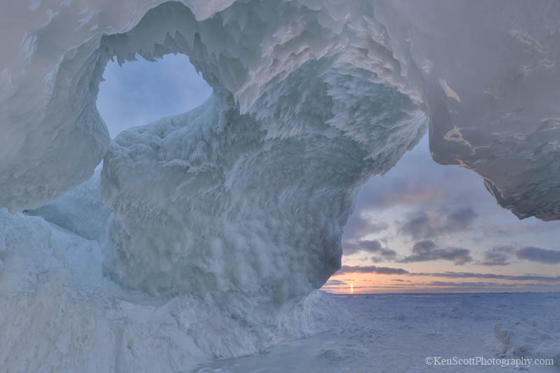
So much ice, everywhere, photo by caterleelanau

At night, as cold settles in, lake ice creaks and groans. It’s been excessively cold, and I camped exposed on the snow-swept surface. Other than the lack of vegetation and the sounds at night, you’d never know you were on a lake. It feels like an empty plain. In some places, you see pressure ridges where ice has pushed into itself, sticking up like clear blue stegosaurus plates.
~ Author Craig Childs on Lake Superior

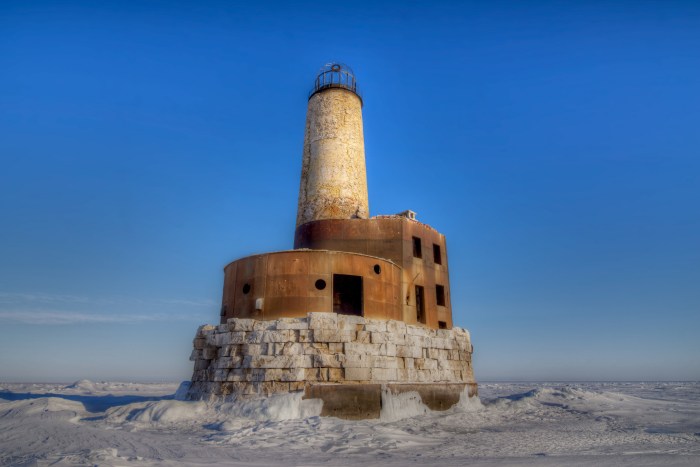
From the latest satellite photo, it looks like Lake Huron is 100% frozen with Superior & Erie 95% and Michigan somewhere in the 85% area. Ontario is looking like the slacker right now, and you can follow along and see daily satellite shots from NOAA.

The NASA Goddard Space Flight Center provided the quotation above and reported on the Great Freeze Over the Great Lakes saying (in part):

Scientists say it’s understandable that the Great Lakes have had so much ice this year considering the cold temperatures in the region that persisted through the winter. Cold air temperatures remove heat from the water until it reaches the freezing point, at which point ice begins to form on the surface, explained Nathan Kurtz, cryospheric scientist NASA’s Goddard Space Flight Center in Greenbelt, Md.

“Persistently low temperatures across the Great Lakes region are responsible for the increased areal coverage of the ice,” Kurtz said. “Low temperatures are also the dominant mechanism for thickening the ice, while secondary factors like clouds, snow, and wind also play a role.”

The freeze this year has local implications, including possible changes to snowfall amounts in the Great Lakes area, explained Walt Meier, also a cryospheric scientist at NASA Goddard. When the lakes are primarily open water, cold air picks up moisture from the relatively warm and moist lake water, often resulting in lake effect snow on the lee side of the lakes, on the eastern and southern shores. When the lakes freeze, the lake effect generally shuts down. “Although this year, they’re still picking up a fair amount of snow,” Meier said.

Lake levels could also see an impact by summer, as winter ice cover generally reduces the amount of water available to evaporate during winter months. If that turns out to be the case, it would be “good news for local water supplies, as well as for shipping and recreational use,” Meier said.

A 2012 study in the Journal of Climate by scientists at NOAA’s Great Lakes lab, which included data from MODIS, found that winter season ice cover on Lake Superior has decreased 79 percent from 1973 to 2010. The study also showed that ice cover on the lakes is highly variable and difficult to predict.

Today’s photo was taken on frozen Lake Michigan off the Leelanau shore by my friend and neighbor Cammie, co-owner of Epicure Catering. You can follow her at caterleelanau on Instagram for lots of wintertime fun and summertime food!

More ice on Michigan in Pictures!

Crosseyed & Snowblind

Snowy Owl

Snowy Owl, photo by Sherri & Dan

Enough with the vortexes already.

Sherry & Dan took their photo of a snowy owl near Muskegon. background bigtacular and see more in their 100+ photo Owls slideshow.

More about snowy owls on Michigan in Pictures.

The corner of February and 28th

February and 28th Avenue

February and 28th Avenue, photo by bill.d

Bill hit the trifecta of Michigan in Pictures, the Michpics Facebook and the latest background on Absolute Michigan with his well-named photo.

See it background big and see more in his Winter slideshow.

More winter wallpaper and more trees on Michigan in Pictures.

Silver Lake in Black & White

Silver Lake

Silver Lake, photo by Jeff Gaydash

View Jeff’s photo bigger, see more in his black & white slideshow and definitely check out more photos from Jeff on Michigan in Pictures.

More black & white photography on Michigan in Pictures.

Winter at Tahquamenon Falls

Winter at Tahquamenon Falls Michigan's Upper Peninsula

Winter at Tahquamenon Falls, Michigan’s Upper Peninsula, photo by Michigan Nut

John took this shot a couple of months ago at Michigan’s largest waterfall. Several years the crew from Wild Weekend TV went to the falls in wintertime. They talked with Lark Ludlow, owner of the Tahquamenon Falls Brewery and Pub about the history & lore of the Tahquamenon Falls – click to check it out.

Check it out bigger and see more in John’s Tahquamenon Falls slideshow. Don’t sleep on his Michigan Nut Photography page on Facebook either!

Lots more Tahquamenon Falls on Michigan in Pictures.

Snowblind

Snowblind...

Snowblind…, photo by Photography by Kenneh

I’m tempted to visualize this plane as leaving for someplace warm.

View Kenneth’s photo bigger and see more in his Sunrises & Sunsets slideshow.

Winter at Turnip Rock

"Turnip Rock" Pointe Aux Barques, Lake Huron

“Turnip Rock” Pointe Aux Barques, Lake Huron, photo by Michigan Nut

Michigan’s Little Finger has been getting a lot of national media attention for the fantastic ice caves that have formed off the Leelanau Peninsula, but it’s a good time to check out the Thumb as well! Turnip Rock is on private property and reachable in the summer only by boat. In wintertime, however, walking on publicly owned Lake Huron becomes an option.

The Point Aux Barques – Turnip Rock geocache explains:

Everyone that received their grade school education in Michigan learned that glaciers pushed their way over Michigan several times. The result is glacial drift averaging 200 to 300 feet deep covering on top of the bedrock. The thickness of drift has measured over 1,000 feet in a few Michigan locations. Rarely can we see exposed bedrock that has been sculptured by non glacier forces. This is one of the locations in southern Michigan where the sandstone bedrock is exposed at the surface. The amount of shoreline that has exposed sandstone is about one mile, but a lot of beauty has been sculptured in the stone.

The locals call the main structure here “Turnip Rock”, because of it’s shape. Geologists call it a “Sea Stack”. A definition of a sea stack is an isolated pillar-like rocky island or mass near a cliff shore, detached from a headland by wave erosion assisted by weathering. Waves force air and small pieces of rock into small cracks, future opening them. The cracks then gradually get larger and turn into a small cave. When the cave wears through the headland, an arch forms. Further erosion causes the arch to collapse. This causes a pillar of hard rock standing away from the coast. Generally occurring in sedimentary rocks, sea stacks can occur in any rock type.

Here’s a map to Turnip Rock.

View John’s photo bigger and see more including nearby Point Aux Barques Lighthouse in his Lake Huron slideshow.

The Ice Caves of Leelanau

IMPORTANT SAFETY UPDATE! The Leelanau County Sheriff’s Department has declared the ice caves on Lake Michigan unsafe!! The winds have moved the ice and there is now open water within feet of the caves, and the strong winds expected today and tomorrow will continue to push water and ice inland. There are also large cracks in the arches and they are expected to start collapsing soon.

Lake Michigan … ice cave sunset II by Ken Scott

Ken Scott took a trip out to the massive ice caves off the shore of the Leelanau Peninsula near Traverse City. You can see a fantastic video of his explorations and should definitely take a minute to watch his cautionary video showing the cracks that can form in these massive structures. There are few things less forgiving than the Great Lakes in winter, and with temps forecast in the upper 30s for tomorrow, things could get very dangerous.

View Ken’s photo bigger and see more in his Ice Cave slideshow.

Although ice caves and similar formations form every winter on Michigan’s shoreline, these ones are particularly incredible due to the greater than normal mass of ice generating more force. They have made it all the way to national news and have drawn thousands of visitors. A couple more features are at Huffington Post, another nice YouTube video showing the structures and the crowds and this mLive article with directions.