Christmas Memories

Christmas Memories

Christmas Memories, photo by Richard Deming Photography

Here’s hoping that whatever holiday you are celebrating this season is wonderful. Thanks everyone for being a part of Michigan in Pictures!

View Richard’s photo bigger and see more in his Christmas Time 2010 slideshow.

Winter Solstice: Ten seconds at Tahquamenon edition

winter-solstice-at-tahquamenon-falls

winter solstice, upper tahquamenon falls, michigan, photo by twurdemann

I wrote that the actual moment of the solstice was 11:48 PM last night, but it’s actually TONIGHT!  Anyway, here’s a simply gorgeous photo from the 2013 winter solstice at Tahquamenon Falls to kick off the shortest day of the year. I hope you can fit everything in and get a great start to your week!

View twurdemann’s incredible ten-second exposure bigger and see more including some more shots of the dramatically different scene at the Falls in 2013 in his winter slideshow.

Lots more Tahquamenon Falls and more about the winter solstice on Michigan in Pictures!

Where’s Winter? (Hint: ask El Niño)

Where's Winter

Where’s Winter?, photo by Daniel Frei Photography

Dan writes:

WANTED: millions and billions and zillions of these pretty things!

Retweet if you want snow too!

But how likely is snow? Here’s an in-depth report by Jessica Eggert on the likliehood (or lack thereof) of snow by Christmas Day that draws from a number of sources and pegs Detroit’s chances at just 46%. For the why behind this, check out Jeff Masters’ report on the warmest meteorological autumn on record:

Meteorological autumn (September – November) was the warmest in 121 years of recordkeeping for the 48 contiguous U.S. states, according to NOAA’s national wrapup of November and fall conditions released Wednesday morning. The national average of 56.8°F was a full 3.3°F above the 20th-century average and 0.2°F above the previous record of 56.6°F (Sep-Nov 1963). Only one state (Florida) had its warmest autumn on record, but the nation as a whole still came out on top because of the rare coast-to-coast nature of the warmth. (FYI Michigan was 120 out of 121 years in 2015)

The dynamics associated with El Niño are likely to keep unusually mild weather predominating over the northern U.S. for most of the winter, according to seasonal outlooks from the National Weather Service.

View & share Dan’s photo from his Twitter and see more and purchase prints at his photography website.

More snow on Michigan in Pictures!

PS: Here’s a great article about snow by Jerry Dennis with illustrations by Glenn Wolff titled Nature Baroque Snowflakes & Crystals that I shared in my online magazine the Northern Michigan Journal a decade ago.

When did summer end?

When Did Summer End

When did summer end?, photo by Cameron

Cameron took this 30 second exposure in heavy snowfall last week at Upland Hills Farm, which looks like a pretty cool place.

View the photo background bigtacular and see more in his Upland Hills Farm slideshow.

More winter wallpaper on Michigan in Pictures.

December 1st … Back into the Woods Day

Sit for a Spell

sit for a spell, photo by Doug Jonas

Longtime readers may know that I celebrate December 1st as “Back into the Woods Day” because for my money, the hardest 15 days for the year for the non-hunting lover of the outdoors in Michigan are November 15-30th. Enjoy as you will – orange clothing not required!

The photo was taken in Michigan State University’s W.K. Kellogg Experimental Forest in Augusta, midway between Kalamazoo & Battle Creek:

Established on abandoned agricultural land, the 716-acre Kellogg Experimental Forest is known worldwide for research on tree breeding and genetics, planting techniques, and plantation establishment and management. Much of the research that developed the Spartan spruce, a hybrid that combines the color and drought resistance of a blue spruce and the softer needles and rapid growth rate of the white spruce, was done at the Kellogg Forest. The forest is open to the public for biking, hiking, horseback riding and cross-country skiing, and has several interpretive trails.

Click for visitor information and there’s also some videos of what researchers are up to that show some of this beautiful spot.

Doug says this was an enchanted afternoon in the woods, with sun, shadow, snow and reflected sky. View his photo background bigilicious and click for more of his great Michigan photos.

More winter wallpaper and lots more parks & trails on Michigan in Pictures!

Snowvember in Michigan

Thanksgiving Snow - Pine Cone Edition

Thanksgiving Snow – Pine Cone Edition, photo by Tom Hughes

Much of Michigan, particularly the southern 2/3 of the Lower Peninsula, is bracing for significant snowfall – as much as 6″ by Sunday morning according to mLive’s Mark Torregrossa:

Snow, possibly mixed with rain, will start in the southwest corner of Lower Michigan after 2 a.m. Saturday, Nov. 21. This includes Muskegon, Grand Rapids and Kalamazoo. By 8 a.m. Saturday, wet snow, mixed with rain, will have spread into southeastern Lower Michigan, including Lansing, Jackson, Ann Arbor, Detroit, Flint, Saginaw, Bay City and Midland. Snow should make it into northern Lower Michigan, including Traverse City, Houghton Lake and Alpena by early Saturday afternoon.

The morning will have temperatures between 32 degrees and 35 degrees. Snow will probably struggle to accumulate during the morning.

All of the model data is now consistent that the storm center will intensify during the afternoon. Precipitation will be heaviest during the afternoon and early evening Saturday.

That’s when the driving conditions will likely worsen dramatically and possibly quickly.

The colder air, with temperatures of about 31 degrees will move in to southern Lower between 3 p.m. and 6 p.m. At the same time there could be a fairly heavy rate of snow.

Read on for more at mLive. If you’re feeling sad, remember that last November was the snowiest since 1897 in much of Michigan!!

View Tom’s photo bigger and see more in his Rochester MI slideshow.

Also tune in to November snow in the Absolute Michigan pool on Flickr for photos at they are added!

A Pair of Predictions for Winter 2016

The ice, with some people thrown in for scale

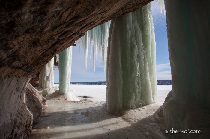
The ice, with some people thrown in for scale., photo by Bill Dolak

It was nice to read NOAA’s forecast for Winter 2016 predicting that El Niño will give us a warmer than normal winter in Michigan:

One of the stronger effects of El Niño is warmer than normal winter temperatures from the Pacific Northwest through the northern Plains into the Great Lakes. NOAA places most of Lower Michigan in an area with a greater than 50 percent chance of warmer than normal temperatures. That also means there is a 33 percent chance of normal temperatures and a 17 percent chance of below normal temperatures.

So, it’s not a sure bet that it will be a warmer-than-normal winter, but indications are strongly leaning in the warmer direction.

The farther north you are in Michigan, the higher the chance of warmer-than-normal temperatures. The Upper Peninsula has at least a 60 percent chance of warmer-than-normal winter temperatures.

If you read on at mLive, meteorologist Mark Torregrossa has some caveats that temper this a bit. You can also just throw big buckets of frozen water on the whole idea of a warmer winter if you believe in the Farmers’ Almanac 2016 Winter Forecast where they predict that:

…the winter of 2015–2016 is looking like a repeat of last winter, at least in terms of temperatures with unseasonably cold conditions over the Atlantic Seaboard, eastern portions of the Great Lakes, and the lower peninsula of Michigan, Ohio, Kentucky, most of the Tennessee and Mississippi Valley, as well as much of the Gulf Coast.

Gack. For the record, the Almanac has nailed the last two winters for Michigan…

Bill took this shot in March of 2015 on the heels of the most brutal winter that Michigan had seen since … well … 2014. View it background bigtacular and see more in his South Haven slideshow.

More winter and more weather on Michigan in Pictures.

Fall…ing: Michigan is Still Michigan Edition

Fall-ing Northern Marquette County

Fall…ing, photo by Thom Skelding

Yep. This photo pretty much sums up the weekend!! In Michigan gets bragging rights to first heavy snow east of Rockies, mLive meteorologist Mark Torregrossa writes:

Michigan now has bragging rights to the first heavy snow of the winter, east of the Rockies. Overnight Friday, October 16, 2015, and this morning, lake effect snow has been falling in part of the Upper Peninsula and a large area of northwest Lower Michigan.

The Kalkaska area, east of Traverse City, has officially reported 5.7 inches of new snow.

The northwest Lower Michigan snow belt has received areas of two to five inches of the winter wonder.

Click through for more, including some photos.

View Thom’s photo background bigtacular and see more in his slideshow.

More fall wallpaper and more winter wallpaper

Winter Is Coming … apparently tonight

North Country Girls

North Country Girls, photo by Michael

While El Niño is predicted to bring a milder winter for Michigan in 2016, it looks like things will kick off early with a chance of a dusting of snow tonight & tomorrow:

The coldest air of the season will pour into state on Friday and into the weekend. The cold air will bring widespread lake-effect rain showers to West Michigan. The rain may mix with some wet snow over parts of the state late Friday into Saturday afternoon.

A better chance of accumulating snow will be over the higher terrain of Norther Lower Michigan and parts of the Upper Peninsula.

I should add that although you may want to see it from your car with the heater cranked, color around the state is still really nice!

Michael took this last January when Detroit was locked in the grip of the White Walkers. View it background bigtacular and see more in his slideshow.

More Detroit and more winter on Michigan in Pictures!

Winter is Coming … and it might not be all that bad

Munising Ice Caves

munising ice caves/curtains, photo by Paul Wojtkowski

The Freep reports that El Niño in Pacific could mean mild Michigan winter:

Less ice on the Great Lakes would ease the freighter shipping industry’s logistical nightmares of recent winters. Less snow-melt runoff in the spring could forestall flooding that sends nutrients off farms and into Lake Erie, fueling its summer algae blooms. And deer populations that have dropped dramatically in the Upper Peninsula over recent harsh winters could begin to rebound.

…Over a century, comparing Michigan’s normal winter precipitation versus 10 El Niño events between 1915 and 1992, rain and snowfall was about 72% of normal in the Metro Detroit area during the El Niños; 78% of normal in the Thumb area, and in the 80% to 85% range of normal throughout the rest of lower Michigan and the eastern Upper Peninsula, according to NOAA.

You can read on for more. While that means that we might not have as much ice cave fun in Michigan this winter, I think I’m OK with an El Niño intermission!

Check Paul’s photo of this winter’s incredible ice caves on Grand Island out background bigalicious, see more in his slideshow and follow Paul Wojtkowski Photography on Facebook!

More ice caves on Michigan in Pictures!