Nawadaha Falls and the Sweet Singer of Hiawatha

Nawadaha Falls

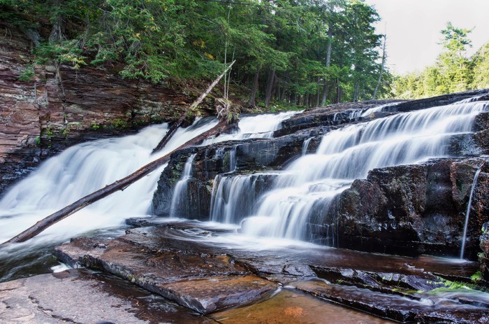
Nawadaha Falls, photo by Jason W Lacey

Should you ask me, whence these stories, whence these legends and traditions,
With the odors of the forest, with the dew and damp of meadows,
With the curling smoke of wigwams, with the rushing of great rivers,
With their frequent repetitions, and their wild reverberations,
As of thunder in the mountains.

I should answer, I should tell you: “From the forests and the prairies,
From the great lakes of the Northland, from the land of the Ojibways,
From the land of the Dacotahs, from the mountains, moors, and fenlands,
Where the heron, the Shuh-shuh-gah,  feeds among the reeds and rushes.
I repeat them as I heard them.
From the lips of Nawadaha, the musician, the sweet singer.”

~Henry Wadsworth Longfellow, The Song of Hiawatha

You may already be aware that one of the main purposes of this blog is to allow me to indulge in my passion for Michigan and its history. Names of the first people who dwelt in Michigan are of particular interest to me, and I was very gratified to discover not only that nawadjiwan is an Ojibway word meaning in the midst of the rapids, but also that it was the name of the singer who taught Longfellow The Song of Hiawatha.

I almost had to leave it there, but then I found a reference in Michael Witgen’s book An Infinity of Nations: How the Native New World Shaped Early North America.

Longfellow acknowledges Schoolcraft’s influence on veiled fashion, when he tells the reader he learned Hiawatha’s story “from the lips of Nawadaha.”  Few readers would realize that this was the Indian agent’s Ojibwe name. Logfellow asserts that Nawadaha had merely repeated these stories, not unlike himself and not unlike an Indian sitting in his lodge on long winter nights telling stories to amuse the children.

You can read on for the author’s puzzlement that Michigan Indian agent Henry Rowe Schoolcraft – himself married to a native woman Jane Johnston Schoolcraft (Oshauguscodawaquat) – would tell tales that are in large part false. As the Wikipedia entry on the Song of Hiawatha notes however,  Longfellow was far more concerned with excitement over accuracy and made numerous editorial decisions in the construction of his epic poem.

GoWaterfalling.com says that Nawadaha Falls is the upper most of the three falls along the Presque Isle Rivers final stretch.

This is a low, wide waterfall. Its width varies greatly depending on the water levels. Nawadaha Falls is similar to but a little higher than Manido Falls. The steepest part of the falls is on the eastern side, and when the river is low, most of the water flows there. There is a nice natural overlook out in front of this drop easily reached from the trail on the east side of the river.

South Boundary Road is not to far beyond Nawadaha Falls. You can cross river here and hike down the other side to make a loop around all the Presque Isle Falls. The eastern side is much wilder, but the whole hike is very enjoyable.

They add that Manabezho Falls is the larger and most interesting but that the whole hike is well worth it. To bring this full circle, the figure that Hiawatha is modeled on is the trickster god and emissary of the Great Spirit, Manabezho.

Check this out background bigtacular and see more in Jason’s great Michigan slideshow.

Many more Michigan waterfalls on Michigan in Pictures!

Waterfall Wednesday: Greenstone Falls

All About Fall - Greenstone Falls (Porcupine Mountains State Park - Upper Michigan)

All About Fall – Greenstone Falls (Porcupine Mountains State Park – Upper Michigan), photo by Aaron C. Jors

GoWaterfalling’s minor waterfalls page says:

Greenstone Falls is a small scenic falls on the Little Carp River. The falls is about 20′ wide, and less than 10′ high. This is the most easily reached of the “backcountry” falls in Porcupine Mountains State Park, being about 1/2 mile from the trailhead. The trailhead to the falls is at the end of Little Carp River road. If you continue on the trail for another 2+ miles you will reach the much larger Trappers Falls.

Trappers Falls looks like a pretty cool natural waterslide!

Check this out on black and see more in Aaron’s great Waterfalls slideshow. Aaron has several more waterfall shots on Michigan in Pictures too.

Many more Michigan waterfalls on Michigan in Pictures.

Michigan Wild & Scenic Rivers: Au Sable River

Changing Skies over the Au Sable HDR

Changing Skies over the Au Sable HDR, photo by hz536n/George Thomas

It is hereby declared to be the policy of the United States that certain selected rivers of the Nation which, with their immediate environments, possess outstandingly remarkable scenic, recreational, geologic, fish and wildlife, historic, cultural or other similar values, shall be preserved in free-flowing condition, and that they and their immediate environments shall be protected for the benefit and enjoyment of present and future generations.

~Wild & Scenic Rivers Act, October 2, 1968

Michigan’s has 16 Wild & Scenic Rivers. One of these is the Au Sable River. The 23 mile stretch of the river from Mio downstream to the 401 Bridge is the portion that has the National Scenic River designation, considered to offer some of the best canoeing in Michigan. It’s also a blue ribbon trout stream with excellent brown trout fly fishing and holding walleye, pike and bass as well.

With all that going for it, I was surprised by the lack of quality information available online about this river. Sometimes, having to dive a little deeper pays off as it has this morning with Michigan’s Au Sable River: Today and Tomorrow by G. E. Hendrickson. The paper was prepared way back in 1966 for the Michigan Department of Conservation under Gov. George Romney’s administration in conjunction with the Geological Survey and the United States Department of the Interior.

Located in the northern lower peninsula of Michigan, the Au Sable is known for its high water quality, scenery, recreational opportunities, coldwater fishery, and historic and cultural significance. It may just be the. If that were not enough reason to visit the river, the Au Sable is also one of the best canoeing rivers in the Midwest.

Two south-flowing rivers rise in the country north of Grayling. One, the Manistee, turns west to Lake Michigan; the other, the Au Sable, turns east to Lake Huron. Both are famous trout streams, but the Au Sable is perhaps enjoyed and cherished by more people than any other Michigan river. Cool clean flowing water, natural cover, and gravel spawning beds make it an outstanding trout stream. Its natural beauty attracts canoeists, campers, and cabin dwellers.

The upper Au Sable is a young river, as rivers go, having settled down to its present course after the glaciers retreated about 12,000 years ago. It was named by early French explorers, the name meaning “River of Sands.” Following close on the heels of the retreating ice, the earliest Indians moved into Michigan, and possibly into the Au Sable area. The Indians hunted for deer, bear, mastodons, giant beaver, caribou, and other wildlife. They also fished for many species. To the Indians the Au Sable was a source of food and drink and a highway for canoe travel. Early white traders and explorers used the river for the same purposes, while the lumbermen valued it chiefly for transporting logs.

You can read on for a lot more including the story of the extinction of the Au Sable river Grayling and Au Sable River drift boats.

Check this out background bigtacular and see a ton more in George’s Fall & Autumn slideshow.

More of Michigan’s Wild & Scenic Rivers on Michigan in Pictures.

Waterfall Wednesday: A Fall Morning at Bond Falls

Morning fog

Morning fog, photo by adonyvan

Bond Falls is is one of Michigan’s most beautiful waterfalls and a frequent guest on this blog. Click for more Bond Falls photos from Michigan in Pictures including a great one from a month ago of Bond Falls under the stars by the same photographer!

Check this out on black and see much more in Jiqing Fan’s Houghton & UP MI slideshow.

There’s more Michigan waterfalls and more Michigan sunrises on Michigan in Pictures.

Fall is a great time to be nuts for Michigan

“The Rushing Tahquamenaw”   Tahquamenon Falls, Upper Michigan (explore # 258 Oct. 9, 2010)

The Rushing Tahquamenaw” Tahquamenon Falls, Upper Michigan, photo by Michigan Nut

Last week the Lansing State Journal asked Michigan in Pictures regular John McCormick aka Michigan Nut Photography about his favorite Michigan color touring destinations. His list is features five fantastic fall locations: Porcupine Mountains, Pictured Rocks National Lakeshore, the Cadillac area, Sleeping Bear Dunes National Lakeshore and the Tahquamenon Falls.

It’s a great list and John is a tremendous landscape photographer. About this photo John writes:

The Brown color of the water in the Tahquamenon River comes from tannins leached from the dense Cedar-Hemlock-Spruce swamps in the river’s headwaters. The river’s total watershed encompasses more than 790 square miles. The Tahquamenon River flows into Lake Superior, after winding nearly 100 miles through Michigan’s Upper Peninsula to empty into Whitefish Bay.

This is the land of Longfellow’s Hiawatha (“by the rushing Tahquamenaw” Hiawatha built his canoe). The Objibwa Indians lived in this rich land of fish, fur, and big game. In the late 1800’s, much of the region was logged off, with the Tahq River being one of the main tranportation routes to drive logs to the sawmills. Today, the falls are protected by this wonderful Michigan State Park for all to enjoy.

See his work at Michigan Nut Photography or dive in to his spectacular Autumn in Michigan slideshow.

Lots more about Tahquamenon Falls on Michigan in Pictures.

September’s Full Moon … and lighting the Grand Rapids sky

Downtown Grand Rapids

Downtown Grand Rapids, photo by NightFox Photography

The autumnal equinox happened on Saturday, making the full moon that will rise this Sunday, September 30th the Harvest Moon. It’s also known as the Wine Moon, the Singing Moon (Celtic), Barley Moon (Old English) and the Elk Call Moon.

This weekend the skies of Grand Rapids will host another interesting phenomenon, Lights in the Night. On Friday (Sept 28) this ArtPrize entry will seek to launch thousands of fire lanterns downtown. Get all the details at www.lightsinthenight.org.

Check this out on black and see more in Cory’s Grand Rapids slideshow.

Gabbro Falls and the Black River Scenic Byway

From Above - Gabbro Falls (Black River - Upper Michigan)

From Above – Gabbro Falls (Black River – Upper Michigan), photo by Aaron C. Jors

Gabbro Falls is one of several very nice waterfalls on the Black River. Others are Great Conglomerate Falls, Gorge Falls, Potawatomi Falls, Sandstone Falls and Rainbow Falls – click that link for more info from GoWaterfalling.com.

The Black River Scenic Byway:

…is in the western corner of Michigan’s Upper Peninsula, near the Wisconsin state line. The byway begins in Bessemer and travels north to the road’s end on the shores of Lake Superior. Black River is 15 miles long and follows North Moore Street, Saint Johns Road, and Black River Road (CR 513). All are two-lane paved roads suitable for all types of vehicles. The byway is open year-round.

The Black River scenic byway crosses the Ottawa National Forest alongside the meandering Black River through areas of old growth hemlock and hardwoods of the Black River Valley. The byway offers scenic views of the distant Porcupine Mountains. In autumn, the byway is bathed in colors of red, orange, and gold.

Aaron’s photo from early October of 2010 certainly bears that out. See it on black and view more in his awesome Waterfalls slideshow.

More waterfalls on Michigan in Pictures.

What’s in a Name? Tahquamenon Falls edition

Tahquamenon Falls

Tahquamenon Falls, photo by AndrewH324

We’ll close out Waterfall Week on Michigan in Pictures with this photo that has been the cover photo on the Absolute Michigan Facebook all week. Here’s hoping that you get a chance to enjoy one of Michigan’s nearly 200 waterfalls soon!

With a drop of nearly 50 feet, a width of over 200 feet and a maximum flow of more than 50,000 gallons of water, the Upper Tahquamenon Falls are one of the largest waterfalls east of the Mississippi. Pronounced about how it looks – like “phenomenon,” the falls gained fame way back in 1856 in Henry Wadsworth Longfellow’s Song of Hiawatha:

Lay aside your cloak, O Birch-tree! lay aside your white-skin wrapper,
For the Summer-time is coming, and the sun is warm in heaven,
And you need no white-skin wrapper!” thus aloud cried Hiawatha
In the solitary forest, by the rushing Taquamenaw

A feature back in 2006 from the Chicago Tribune offers one popular theory for the name:

The river and its two falls (the smaller Lower Falls are further downstream) are located in the northeast part of Michigan’s Upper Peninsula, just miles from Lake Superior, in the 46,000-acre Tahquamenon Falls State Park. The Upper Falls is one of the largest waterfalls this side of the Mississippi in the United States. (Niagara–shared with Canada–is the largest.)The park is dense with both hardwoods and pine and filled with wildlife. Sightings of moose, gray wolves, black bears, American martens and river otters are typical, and have always been an attraction for nature lovers–including Henry Wadsworth Longfellow, whose poem about this area recounts how Hiawatha built his canoe “by the rushing Tahquamenaw.” The spelling was a variation of Tahquamenon, which comes from an Ojibwa word meaning “dark berry.”

Origins of the Name from the Michigan DNR suggests an alternative root of the name:

The word Tahquamenon has not been as easy to trace. There have been many theories to the origins of this name, such as the color of the water of the Tahquamenon River or meaning the place of the blueberry swamps.

In his book, “Lake Superior Place Names: From Bawating to the Montreal,” Dr. Bernard C. Peters sheds additional light on the subject. Peters suggests the word Tahquamenon comes from the word Outakouaminan, which appears on a 1671 Jesuit map. The key is its location on the map. Because it is shown near an island in what now is Whitefish Bay, Peters believes the name actually refers to a shortcut across the bay.

Wherever the name came from, there’s no doubt that this is a “can’t miss” waterfall. You can get the 411 on Tahquamenon Falls at Go Waterfalling.com and see a video of the case for the falls as one of the Seven Wonders of Michigan. Also check out this great video of the falls from 1950 and see a cool old photo of the falls right here.

Check this photo out background bigtacular and in Andrew’s Upper Peninsula slideshow.

Lots more Tahquamenon Falls on Michigan in Pictures.

Quartzite Falls

Quartzite Falls

Quartzite Falls, photo by Marty Hogan

GoWaterfalling says that Quartzite Falls is one of the waterfalls on the Slate River in Baraga County, a remote wild river in the UP that has numerous drops as it makes it way to Lake Superior. Waterfalls of the Keweenaw Area, a cool waterfall site I discovered the other day, says that Quartzite Falls is:

A small waterfall with a sharp, uniform drop shaped like a bowed-in circle. Water falls straight down onto a flat piece of slate and slides down into a large, deep pool surrounded by cedars.

Click through for directions and a couple of photo galleries.

See this on black and see more in Marty’s Baraga County slideshow.

More waterfalls on Michigan in Pictures and also check out a nice video from Quartzite Falls.

Ocqueoc Falls, a big fish in a small pond

Ocqueoc Falls

Ocqueoc Falls, photo by joeldinda

Way back in 2006 Michigan in Pictures featured another photo of Ocqueoc Falls. If towering falls are what you’re looking for, you’ll probably need to keep looking. GoWaterfalling.com has this to say about Ocequeoc Falls near Onaway:

Ocqueoc Falls is the only “major” waterfall in Michigan’s lower peninsula. In rockier, hillier parts of the world this would be a nameless rapids of no note but here in the farmlands and forests of Michigan it merits its own little park. The falls is at most 5 feet high. There is a small gorge below the falls, with rocky walls about 20 feet high. The Ocqueoc Falls State Forest Campground is just across the road, and the Bicentennial Pathway passes by the falls.

Check this out background bigtacular and see more in Joel’s Waterfalls slideshow.

More Michigan waterfalls on Michigan in Pictures!