Waterfall Wednesday: Manido Falls in the Porcupine Mountains

Turbulence (Manido Falls, Porcupine Mountain)

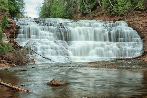
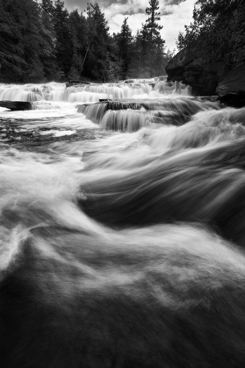
Turbulence (Manido Falls, Porcupine Mountain), photo by Jiqing Fan

The Waterfall Record’s entry for Manido Falls says:

Manido Falls did not impress me at first, at least not as much as the downstream Manabezho Falls. After seeing the pictures I had taken, though, I discovered what an amazingly beautiful waterfall Manido Falls is. Its beauty comes from its complexity. The waterfall itself is not very tall at all. It is wide, though. As the Presque Isle River tumbles down toward Lake Superior, it comes to this set of rocks that create a beautifully cascading waterfall. I think what makes me like Manido Falls so much is that the water has taken such an interesting course here, erosion taking its effect in an oddly unique way.

Add to it that the just as spectacular Manabezho Falls is only hundreds of yards away, and Lake Superior not much more distant, this makes for one of the most beautiful waterfall stretches in the Upper Peninsula.

Visit #2: When my father and I visited Mandido Falls in late September 2010, the falls looked completely different due to the significant amounts of rainfall in the weeks previous.

Read on for directions and some photos.

View Jiqing Fan’s photo bigger and see more in his Houghton & UP MI slideshow.

More black & white photography and (many) more Michigan waterfalls on Michigan in Pictures!

Night Mill: Dundee’s Old Mill Museum

Night Mill

Night Mill, photo by The Ottolab

The Old Mill Museum is Dundee’s historical museum. Their history page says that over the years, it has served as a grist mill, hydro-electric power plant, Ford factory and fabricating factory.

The three-story frame mill as we know it was built in 1848-49 by Alfred Wilkerson, as a grist mill. The nearby dam had been constructed out of logs in 1846.

The building is of Greek Revival design, popular in Monroe County in the 1840s. “It is compact, geometric and of exquisite proportion,” according to the community’s Sesquicentennial Book, published in 1974.

The windows are double-hung with multiple lights. The exterior doors are divided horizontally (Dutch) and the overall design is symmetrical.

Hand-hewn beams, 10×10 inches for the main columns, support the building. The roof, floors and other connections were made with oak pegs. No longer existing are two smaller additions at the rear of the mill which were used to store flour barrels and milling tools during the building’s grist mill days.

Read on for much more.

View the Ottolab’s night exposure of the mill background bigtacular and see more in his slideshow.

Waterfall Wednesday: Agate Falls on the Ontonagon River

Agate Falls, Bruce Crossing, MI, April, 2010

Agate Falls, Bruce Crossing, MI, April, 2010, photo by Norm Powell

GoWaterfalling.com is the site for Michigan waterfalls. Their page on Agate Falls says that this pretty waterfall is relatively easy to get to and adds:

Agate Falls is a Michigan State Scenic Site 6.5 miles east of Bruce Crossing on MI-28. There is a roadside park (Joseph F. Oravec roadside park) just past the bridge over the Ontonagon River. Unfortunately the provided trails and overlooks are somewhat limited. With some effort you can scramble down to the river to get some very good views of the falls, which seems to be popular with local fishermen, or scramble up the river banks to get to the old railroad bridge over the falls. The bridge is now part of a snowmobile trail.

Bond Falls is just around the corner. From Agate Falls, go east on MI-28 and take a right onto Agate road.O Kun de Kun Falls is 8 miles to the north. Go west on MI-28 and turn north on to US-45.

View Norm’s photo bigger and see more (including Bond Falls and other waterfalls) in his great Michigan Upper Peninsula – April 2010 slideshow.

Many more Michigan waterfalls and also more about the Ontonagon River on Michigan in Pictures!

Perils of Michigan: Quicksand Edition

Sturgeon River by Sven

Sturgeon River, photo by Sven

While the ice has melted, leaving the shorelines temporarily free of peril – at least until until bodysurfing season starts – we can take a moment to worry about quicksand. Quicksand in Michigan Streams from Fichigan says:

Everything I know about quicksand I learned from Tarzan movies. The main thing to know is: bad guys don’t make it out, but good guys and gals always do. If you’re a bad guy, please stop reading. Quicksand on a trout stream is a little different than sand bogs in Africa, but there’s some similarity. They are both camouflaged so you don’t see it until it’s too late and if you make it out alive you’ll have an interesting story to tell even if no one believes you.

Quicksand on a trout stream is harder to see since it’s underwater. The stream bottom appears normal except there is no visible hole (sand covers it) so you don’t know it’s here until you start sinking. In waders it’s pretty scary since swimming doesn’t feel like an option.

I’ve found quicksand on the Pine River in Lake County and the Sturgeon River in the Pigeon River State Game Area. On the Pine, the particular spot I know of is a few bends downstream from Raymond Road. The first time I ran into it I was alone. I scrambled to get out and it was like running in place up a sand dune. It was easy to see the exact spot afterwards because a cloud of light gray silt poured out like smoke. An hour later, walking the bank downstream, the silt was still pouring out.

Read on for lots more including his encounter on the Sturgeon River.

I can find photos of almost anything View Sven’s photo bigger on Flickr and see more in his UP Michigan slideshow.

The Sturgeon River is one of Michigan’s Wild & Scenic Rivers – more Sturgeon River on Michigan in Pictures.

Know your Michigan Turtles: Spiny Soft-shell Turtle

Soft Shell Attracts Seed Pods

Soft Shell Attracts Seed Pods, photo by David Mayer

One of the most popular posts on Michigan in Pictures is Know Your Michigan Turtles where we now have 8 of Michigan’s 10 turtle species profiled. You can click that link for the list of all of them and read on to learn about the soft shell turtle.

The Spiny Soft-shell Turtle (Apalone spinifera spinifera) entry at the University of Michigan Animal Diversity Web says that:

Apalone spinifera inhabits various freshwater systems such as rivers, lakes, marshes, farm ponds as well as bays of the Great Lakes . Apalone spinifera prefers open habitats with a small amount of vegetation and a sandy or muddy bottom and require sandy raised nesting areas close to water.

…Spiny softshell turtles are diurnal animals, spending most of the day basking in the sun and foraging for food. They can be spotted sunning on logs and river banks. If disturbed, they will quickly retreat into the water and bury themselves in sand, leaving only their heads visible. These turtles are also able to breathe underwater for extended periods through their pharyngeal lining, cloacal lining, and skin. Spiny softshell turtles spend October to April in the water buried underneath substrate in a state of dormancy.

Apalone spinifera preys on on various macroinvertebrates such as aquatic insects, crayfish, and occasionally a fish. They find their food underneath objects, along the floor of the lake, and in vegetation. They also hide in the floor substrate and grab prey as they swim by.

Spiny softshell turtle nests are often destroyed by raccoons, skunks, and foxes. Young softshell turtles are eaten by raccoons, herons, and fish. Adults are killed and eaten only by humans, they have few natural predators. When bothered, spiny softshell turtles will extend their long necks and snap viciously at their attacker, inflicting a painful bite. They are wary and can hide themselves quickly.

Read on for a whole lot more including photos.

David says to be sure to check out the seed pod copter on this turtle’s face! View it background big and see more in his Wildlife slideshow.

Observation Deck coming to Penobscot Building

Guardian Building

Guardian Building, photo by Michael G Smith

Sometimes I find things and forget to post about them. A couple weeks ago, there was a feature from WXYZ in Detroit that the Detroit’s Penobscot Building plans to open observation deck:

New York has the Empire State Building and Rockefeller Center, Chicago has the Hancock Observatory, but the doors to our city’s skyline have been closed for decades.

That’s changing, thanks to the historic Penobscot Building’s new plans to re-open its observation deck.

Kim Farmer has worked at the building since the 1990’s. She has seen owners come and go, but these new plans are what she calls, “pretty gutsy moves.”

“We plan on lighting up here, LED lights comparable to the Empire State Building,” the Vice President of Operations and Leasing told WXYZ.

There are plans to incorporate a banquet facility, and a ticket fee to reach the top. The goal is to complete the observation deck project by summer 2016.

Read on for more and thanks  for the find!

Michael took this shot a couple of years ago from the Penobscot. View it big as a building and see more in his Wirt Rowland, Architect slideshow.

PS: Read more about the Penobscot (once the 8th tallest building in the world and now 2nd tallest in Detroit) and the Guardian Building on Michigan in Pictures. They were both designed by Wirt C. Rowland, who was a heck of an architect!


Icebreaking on the St Mary’s River is an international effort

Icebreaking on the St Marys River

Icebreaking on the St Mary’s River, photo by U.S. Coast Guard Air Station Traverse City

Here’s an aerial shot of the 228-foot Canadian Coast Guard Ship (CCGS) SAMUEL RISLEY working in partnership with U.S. Coast Guard’s Sault Ste. Marie Sector on icebreaking operations in the St. Mary’s River last weekend. They write:

USCG Sector Sault Ste. Marie is also in high gear kicking off the 2015 Operation Taconite season, as ice continues to build daily across the Great Lakes. US Coast Guard and Canadian Coast Guard icebreakers are conducting around the clock icebreaking operations to assist commercial vessel traffic in the connecting waterways of Lake Superior, Lake Michigan, and Lake Huron.

Operation Taconite is the largest domestic icebreaking operation in the US. Over water shipping offers the only effective means of transporting the vast amounts of iron ore from the mines at the Head of the Lakes in Minnesota needed to meet the demands of steel mills in Lake Erie and Lake Michigan. Operation Taconite is primarily responsible for ensuring the successful transport of this cargo amid the harsh winter conditions of the northern Great Lakes.

Air Station MH-65s routinely fly ice reconnaissance flights in support of the operation

The photo was taken by the crew of one of the Traverse City Coast Guard Air Station’s Dolphin helicopters. View it background bigtacular and click through for a shot of the USCG Icebreaker Mackinaw working to keep this vital shipping channel open.

There’s more winter wallpaper and more ships on Michigan in Pictures.

Happy New Year!

Happy New Year!

Happy New Year!, photo by Spring Disney

“I hope that in this year to come, you make mistakes. Because if you are making mistakes, then you are making new things, trying new things, learning, living, pushing yourself, changing yourself, changing your world. You’re doing things you’ve never done before, and more importantly, you’re doing something.”
~Neil Gaiman

Happy New Year everyone! Here’s hoping for health & happiness for all of you, but also a mistake or two as the incomparable Mr. Gaiman prescribes.

Spring Disney shared this photo from Elizabeth Park in Trenton for the 2011 New Year. View it bigger on Flickr and see more (including some absolutely stunning owl photos) in her My Favorites slideshow.

More bridges and more New Year on Michigan in Pictures.

Root Beer Falls

Tahquamenon Falls Root beer falls

Tahquamenon Falls, photo by Courtney Cochran

The Tahquamenon Falls are Michigan’s biggest waterfall and quite a sight to see in any season. It draws its name from the distinctive root beer color of the water which is created by the leaching of tannins from the cedar swamps that feed the river.

At its peak flow, the river drains as much as 50,000 gallons of water per second, making it the second most voluminous vertical waterfall east of the Mississippi River after only Niagara Falls.

View Courtney’s photo bigger and see more in her Landscapes slideshow.

Lots more Tahquamenon Falls on Michigan in Pictures!

Support Michigan in Pictures with Patreon


Quiet water of the Presque Isle River

Presque-Isle-in-the-Porkies

Quiet water of the Presque Isle River. Porcupine Wilderness State Park, photo by Linda Carter

The Porcupine Mountain Wilderness State Park is the area of Michigan where I haven’t yet visited that I’m most fascinated with. One of the cool things for me about putting Michigan in Pictures together is learning new things about places, and Linda’s photo showed me something new about the Park! She writes:

The Presque Isle River (French explorers named it for the little island at the mouth of the river) is the largest and most dangerous flow through the Porcupine Mountains. The 3 waterfalls near its mouth are some of the most scenic in the Upper Peninsula of Michigan. The river forks at the end as it flows to Lake Superior. This picture is the right side, which is quiet and peaceful.

View her photo bigger and see more (including some of those waterfalls) in her Porkies slideshow.