

Mackinac Bridge Tower, photo by A. Runyon.
Amanda assures us that she wasn’t driving.
Head over to Absolute Michigan for a cool look inside the Mackinac Bridge towers and click the button below for lots more Mackinac Bridge info.

Mackinac Bridge Tower, photo by A. Runyon.
Amanda assures us that she wasn’t driving.
Head over to Absolute Michigan for a cool look inside the Mackinac Bridge towers and click the button below for lots more Mackinac Bridge info.

Indians.org tells the story of the creation of Mackinac Island’s Arch Rock and says that even now the bravest of the Ottawa people will not walk over it. My favorite Michigan history book, Lore of the Great Turtle by Dirk Gringhuis, says that Arch Rock was the bridge over which departed souls could find their final resting place and also tells another story of its formation due to an angry father, the Sky Person Evening Star and the tears of She-who-walks-like-mist. (seriously, if you have an 8-12 year olf on your gift list, buy them this book)
Wikipedia’s Arch Rock entry takes a more scientific bent, saying that this 149′ limestone arch formed during the Nipissing post-glacial period, characterized by high Lake Huron levels following the end of the Wisconsin glaciation. Arch Rock is one of several limestone formations in Mackinac Island State Park.
I believe that the boat so perfectly posed in the arch is a “mackinaw boat” (photo).
The photo is from the Detroit Publishing Company collection (c. 1899) at the Library of Congress (LC-USZC2-6399 DLC). You can get a larger view at Flickr and a massive 47 MB TIFF at the Library of Congress.

The photo by rdmegr was taken from high above the Straits of Mackinac, the name for the narrow passage between the Lower and Upper Peninsulas of Michigan. Lake Michigan is on the left and Lake Huron, the right with Mackinaw City (with a “w”) and the Lower Peninsula in the foreground and St. Ignace and the UP in the distance. It’s part of his Daytrip to Mackinac set of photos. Another photo from his flight to Mackinac of a freighter, the North Manitou Shoal Light and South Manitou Island was also blogged to Michigan in Pictures for general coolness and the fact that I heard his plane fly over my house.
I also have a confession to make: For months, I have been scared of the Mackinac Bridge.
This is distinct from the uneasiness that my mild phobia of falling off the Mackinac Bridge gives me when I drive over it.
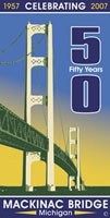 I have been scared because 2007 is the 50th Anniversary of the Mackinac Bridge. To me, other than the lake-etched outline of our state, there is no greater symbol of Michigan than the Mighty Mac.
5 miles long, 552 feet tall in nearly 300 feet of water, the Mackinac Bridge has seen over 120 million crossings required 3 years, over 11,000 people and 4 million tons of concrete and steel to build. (more facts)
And that’s only the barest glimmer of the story that needs to be told. From its conception in the 1800s, through the difficult construction, all the way up to the people who cross it for business or pleasure every day with hardly a pause, the Bridge is an essential part of what joins Michigan’s two peninsulas as one state.
If you have some links to share, please add them in the comments. We’ll be telling the story of the Mackinac Bridge piece by piece here and on Absolute Michigan, and we’ll post links to all the photos, stories and videos on The Mackinac Bridge page at Absolute Michigan. (look for the button!)
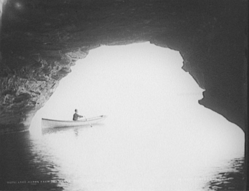
Lake Huron from the caves, Pointe aux Barques
The United States Library of Congress is a shining example of why we need government: to perform the vital work of preserving our heritage. One of the ways you can experience this preserved heritage is through American Memory from the Library of Congress. According to the mission, American Memory provides free and open access through the Internet to written and spoken words, sound recordings, still and moving images, prints, maps, and sheet music that document the American experience. It is a digital record of American history and creativity.
Today’s selection is from a gallery of photos from the collection of the Detroit Publishing Co. taken on and around Lake Huron near Pointe aux Barques and Port Austin in Huron County. It’s a gallery of 20 photos of natural wonders like Turnip Rock and structures such as the Port Austin Reef Light (if that link doesn’t work for you, try the Pointe Aux Barques link on this page).
You can get some great present-day photos of the shoreline at Port Austin Kayak Rental … either in their gallery or by renting a kayak and taking your own! If you have taken any photos of the area, please feel welcome to post links to them in the comments! Port Austin Kayaks also helpfully provided a map link that lets us give you this cool satellite view of the Port Austin shoreline! (I believe that point at the western edge is where Turnip Rock is)
Library of Congress LC-D4-12361
Updated Oct 2, 2008: Check out modern day photos in Kayaking Point Aux Barques!

Au Sable #040, photo by joelmaust.
One of several photos of one of Michigan’s premier trout rivers in winter.
Learn a little more on the Au Sable River from Wikipedia.
NOTE: Minor technical difficulties have delayed Bobby Alcott’s photographer profile – check back tomorrow!

.closed for the season., photo by tEdGuY49.
According to the tags, this photo was taken along US-23 in (or near) the town of Oscoda on the Lake Huron shore.
I kind of sat on this photo for a couple weeks as I had just blogged one from Ted. Looking back through the pictures from Ted that we’ve featured, I realize that he has a special gift for seeing the bright things.

Tawas Point Lighthouse by midmichphotos
This photo is one of a set of lighthouse photos. According to Terry Pepper’s Seeing the Light (which also has a stunning photo of the Tawas light in the 1800s) nothing came easy for those who sought to establish an aid to navigation of Ottawa Point at one end of Tawas Bay on Lake Huron. By the 1870s, scant years after construction of the first light on the point:
By virtue of the prevailing Northeast wind, Ottawa Point had forever been in a state of evolution. Driven by wave and wind, sand from the lake-bed and the shoreline was continually deposited onto the end of the Point, changing its configuration. Over the years since the construction of the Light, this natural reshaping had continued unabated, lengthening the Point by almost a mile, and leaving the old lighthouse “high and dry,” three quarters of a mile from the end of the point it was designed to mark. Additionally, the light had a reputation among mariners as being extremely dim and difficult to see from out in the Lake. The combination of the dimness of the light and its distance from the Point represented a disaster waiting to happen.
Read on for the rest of the story. You can get directions to the light and information about nearby attractions from Michigan.gov and information about Tawas State Park from the DNR. You might also want to check this map of the location of the Tawas Point Lighthouse (and see some other pics taken there).

Last Light, photo by IntangibleArts.
…from the south end of Lake Esau; Presque Isle, Michigan. Sept.06
I was looking for something and then looked at a whole bunch of great photos and then found this one. Hawkins (the photographer) has a blog called Intangible Arts with a post about his September visit to Alpena and the North Michigan woods.

Untitled, photo by jacalynsnana.
This photo is from a couple weeks ago – I’m not ready for fall to be over though!
Part of our Michigan Fall Wallpaper series.
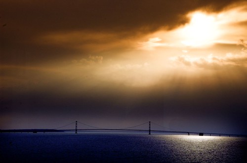
Mackinaw Bridge, photo by wyoming_1.
David Vernon writes:
An interesting picture. Taken from the somewhat world famous Cupola Bar at the Grand Hotel on Mackinac Island, looking west towards the wonderful Mackinaw Bridge. The sun was behind the clouds and setting fast but not entirely influencing life at the bridge colorwise.This shot was taken through a window but you have to look hard to see any reflection.
He can probably be excused for getting the last letter of the bridge wrong (though he is out of the spelling bee!) as he lives near the Mackinaw River in Illinois. Besides, it’s confusing to know whether it’s Mackinac or Mackinaw. Regarding “Mackinac or Mackinaw?”, the St. Ignace Chamber says:
The native people called the area Michinni-makinong. The name was shortened over the years by French and British settlers. In the 1600s, the French pronounced the ending as “aw”, which translated to their spelling as “ac”. Michilimackinac, Fort Mackinac, Mackinac Island the Straits of Mackinac and the Mackinac Bridge are spelled with an “ac”, but pronounced “aw”. Upon the arrival of the British, a village established as Mackinaw was pronounced as “aw” and also spelled that way.
Basically, the bridge and the island are “ac” and the city is “aw”.
