Mackinac’s Round Island Passage Light is for sale

Somewhere in Light

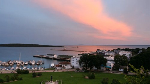
Somewhere in Light, photo by Kristina Austin Scarcelli

mLive reports that the Government Services Administration is taking bids from nonprofit or community groups to take stewardship of the Round Island Passage Light before auctioning it off. Click through for all the details.

Lighthouse Friends has a page on the Round Island Passage Lighthouse that includes the entry from the 1948 Coast Guard Bulletin on this light that replaced the Round Island Lighthouse (in the background on the left):

The substructure of the new lighthouse, 56 feet square up to the 1 foot line below mean low water, is a timber crib with cells at the perimeter filled with concrete and internal cells filled with 5-inch to 14-inch rock. The superstructure is concrete with a reinforced concrete deck. It has four vertical and four sloping sides, giving the lighthouse a new and unusually trim appearance. The tower is appropriately ornamented on each side with a 4- or 5-foot Indian Head plaque, symbolic of the area.

But the most interesting thing about Round Island Passage Light Station is its main light. Located in the top section of the 41 ½-foot tower, it is indeed a departure from the “single light source” arrangement that has been in use for centuries. This new light apparatus is a solid bank of sealed beam lamps of 3,000 candlepower which produce a characteristic of occulting green every 10 seconds. It is visible 16 miles. (These sealed beam lamps are similar to your present day automobile headlights.)

The fog signal consists of two air operated diaphragm horns, sounding simultaneously with 3 seconds blast and 27 seconds silence. The radiobeacon is class B. Distance finding is also provided.

The passage between Mackinac Island and Round Island has long been regarded as extremely hazardous. It is now adequately guarded by Round Island Passage Light Station. This will result in a saving of time on trips and will relieve the congestion of Poe Reef Channel. This, in turn, will increase Great Lakes’ tonnage.

View Kristina’s photo bigger and see more in her Michigan Lighthouses slideshow.

The Making of the Mackinac Bridge

Bridge_HDR2.jpg

Bridge HDR 2, photo by Allison Hopersberger

A calm night on the Straits of Mackinac, and Michigan’s signature bridge was looking fine!

I’ve posted a ton about the Mighty Mackinac Bridge here on Michigan in Pictures, but had never seen this excellent summary of how it came to be courtesy the Michigan Dept. of Transportation’s page on I-75 and the Straits of Mackinac:

The five-mile stretch of water separating Michigan’s two peninsulas, the result of glacial action some twelve thousand years ago, has long served as a major barrier to the movement of people and goods. The three railroads that reached the Straits of Mackinac in the early 1880s, the Michigan Central and the Grand Rapids & Indiana Railway from the south, and the Detroit, Mackinac and Marquette from the north, jointly established the Mackinac Transportation Company in 1881 to operate a railroad car ferry service across the straits. The railroads and their shipping lines developed Mackinac Island into a major vacation destination in the 1880s.

Improved highways along the eastern shores of Michigan’s lower peninsula brought increased automobile traffic to the straits region starting in the 1910s. The state of Michigan initiated an automobile ferry service between St. Ignace and Mackinaw City in 1923 and eventually operated eight ferry boats. In peak travel periods, particularly during deer season, five mile backups and delays of four hours or longer became common at the state docks at Mackinaw City and St. Ignace.

With increased public pressure to break this bottleneck, the Michigan legislature established a Mackinac Straits Bridge Authority in 1934, with the power to issue bonds for bridge construction. The bridge authority supported a proposal first developed in 1921 by Charles Evan Fowler, the bridge engineer who had previously promoted a Detroit-Windsor bridge. Fowler’s plans called for an island-hopping route from the city of Cheboygan to Bois Blanc, Round, and Mackinac islands, thence to St. Ignace, along a twenty-four-mile route. The Public Works Administration flatly rejected a request for loans and grants to implement this project.

A plan was then drawn up for a direct crossing from Mackinaw City to St. Ignace, but they were again denied funds. In 1940, a plan was submitted for a suspension bridge with a main span of 4600 feet. This design was a larger version of the ill-fated Tacoma Narrows Bridge in Washington State, a structure destroyed by high winds on November 7, 1940. Although the disaster delayed any further action, the activities of 1938-1940 nevertheless produced some important results. The bridge authority conducted a series of soundings and borings across the straits and built a causeway extending out 4200 feet from the St. Ignace shore. The Second World War ended any additional work, and the Legislature abolished the bridge authority in 1947.

William Stewart Woodfill, president of the Grand Hotel on Mackinac Island, almost singlehandedly resuscitated the dream of a bridge across the Straits of Mackinac. Woodfill formed the statewide Mackinac Bridge Citizens Committee in 1949 to lobby for a new bridge authority, which the legislature created in 1950. A panel of three prominent engineers conducted a feasibility study and made recommendations to the bridge authority on the location, structure, and design of the bridge.

The State Highway Department, which had just placed a $4.5 million ferryboat, Vacationland, into service at the straits in January 1952, remained hostile to the bridge plan. In April 1952, the Michigan legislature authorized the bridge authority to issue bonds for the project, choose an engineer, and proceed with construction. The authority selected David B. Steinman as the chief engineer in January 1953 and tried unsuccessfully to sell the bridge bonds in April 1953, but by the end of the year, the authority had sold the $99.8 million in revenue bonds needed to begin construction.

View Allison’s photo bigger and see LOTS more in her Mackinac Island slideshow!

Birthday Butterfly for the Grand Hotel

Grand Hotel Birthday Butterfly

Grand Hotel Butterfly, photo by Alicia Bock

Today is the 127th birthday of the Grand Hotel on Mackinac Island. You can check out the Hotel’s historic photo gallery or if you want to roll with the times, the Grand Hotel Instagram.

View Alicia’s photo bigger, see more in her Mackinac slideshow and view and purchase more in the Mackinac Magic photo gallery on her photography website.

More about the Grand Hotel on Michigan in Pictures.

Fort Michilimackinac and Pontiac’s Rebellion

Fort Michilimackinac

Fort Michilamackinac, photo by Mark Swanson

The State of Michigan’s page on Fort Michilimackinac says:

Fort Michilimackinac was built by the French on the south shore of the Straits of Mackinac in approximately 1715. Previously, French presence in the Straits area was focused in what is now St. Ignace where Father Marquette established a Jesuit mission in 1671 and Fort de Baude was established around 1683. In 1701, Cadillac moved the French garrison from St. Ignace to Detroit, which led to the closing of the mission and considerably reduced French occupation in the area. Several years later, as the French sought to expand the fur trade, they built Fort Michilimackinac to re-establish a French presence in the Straits area.

Fort Michilimackinac was a strategically located fortified trading post. The fort was not built primarily as a military facility but as a link in the French trade system, which extended from Montreal through the Great Lakes region and northwest to Lake Winnipeg and beyond. Overlooking the Straits of Mackinac connecting Lake Huron and Lake Michigan, the fort served as a supply post for French traders operating in the western Great Lakes region and as a primary stopping-off point between Montreal and the western country. Fort Michilimackinac was an island of French presence on the frontier from which the French carried out the fur trade, sought alliances with native peoples, and protected their interests against the colonial ambitions of other European nations.

In 1761 the French relinquished Fort Michilimackinac to the British who had assumed control of Canada as a result of their victory in the French and Indian War. Under the British, the fort continued to serve as a major fur trade facility. The Ottawa and Chippewa in the Straits area, however, found British policies harsh compared to those of the French and they resented the British takeover. In 1763 as part of Pontiac’s Rebellion, a group of Chippewa staged a ball game outside the stockade to create a diversion and gain entrance to the post and then attacked and killed most of the British occupants. The use of Fort Michilimackinac came to an end in 1781 when the British abandoned the post and moved to Fort Mackinac on Mackinac Island.

You can get more including visitor information at Colonial Michilimackinac and also check out this History Channel program on Pontiac’s Rebellion (the Michilimackinac story is about 20 minutes in).

View Mark’s photo background big and see more in his Mackinac, Michigan slideshow.

More from Mackinac on Michigan in Pictures!

Lilacs on Mackinac … and lilacs in your garden

Lilacs on Mackinac Island

Lilacs on Mackinac Island, photo by Steven Blair

While lilacs are starting to wind down around the state, they’re just getting going on Mackinac Island. The annual Mackinac Island Lilac Festival started last weekend and continues through Sunday, June 15th. Here’s a few tips courtesy the Lilac Festival and Jeff Young, Lilac Curator at the University of Vermont Horticultural Research Center, Master Gardener and presenter of the “Walk and Talk with Lilacs” program during the Lilac Festival.

  • Common Lilacs need to have 9-12 canes for each 6 feet
  • Leave at least 2 feet between mature Lilacs.
  • Plant new shrubs 16 feet apart (circular shape)
  • Allow for a few more canes if you are planting as a hedge with less depth.
  • If you have too many canes, consider the oldest canes for removal first, leaving good spacing between canes.
  • If not enough canes, pick one or two of the best suckers each year until there are enough.
  • Once the Lilac is established, consider adding one new cane and removing the oldest cane each year to create a vigorous, healthy full flowering plant.

More at the Lilac Festival website.

View Steven’s photo background bigilicious on Facebook and see more at the Artistic Mackinac Gallery & Studio.

More lilacs and more summer wallpaper on Michigan in Pictures!

Michigan Nut’s 2015 Calendar

Moonlit-on-the-Mighty-Mac

Moonlit on the Mighty Mac, photo by John McCormick/Michigan Nut Photography

If you’ve been following Michigan in Pictures for any length of time, you’re probably familiar with the work of John McCormick aka Michigan Nut.

John has just released his 2015 Michigan Wild & Scenic Wall Calendar, and you can get it for just $15. As an added bonus, if you head over to like his post about it on Facebook, you have a chance to win a free one!

The photo above of the Mackinac Bridge is not only the cover of the calendar, it’s also the photo for June. View (and purchase) John’s photo bigger at MichiganNutPhotography.com, see more in his Michigan Bridges Gallery and definitely follow Michigan Nut Photography on Facebook for a regular dose of photographic awesome from the Great Lakes State!

There’s lots more from John on Michigan in Pictures too!!


Blue Anticipation

Blue Anticipation

Blue Anticipation, photo by Elizabeth Glass

I dug way back through the over 13,000 winter photos in the Absolute Michigan pool on Flickr for today’s photo.

Liz Glass took it at the Straits of Mackinac in 2011. She says that the color is real and recommends you check it out bigger to see the details on Fluidr. It’s also a cool way to look at her Ice set (or view the slideshow on Flickr).

More ice on Michigan in Pictures.

Opening the Mackinac Bridge, November 1, 1957

Opening of Mackinac Bridge - November 1, 1957

Opening of Mackinac Bridge – November 1, 1957, photo by daveumich

An Absolute Michigan feature via Michigan History Magazine on the opening of the Mackinac Bridge on November 1, 1957 says (in part):

With the bridge ready for traffic, but fearing inclement autumn weather at the Straits, officials decided to have an official “opening” on November 1, 1957, but an official “dedication” in late June of the following year.

Amazingly, the weather on the first day of November (preceded by two days of rain and fog) was sunny and pleasant. However, the weather in late June was so cold and wet (with six-foot waves on the Straits) that some of the events were shortened or canceled altogether. According to one observer, it “was a bleak, gray day, more like March than June, and the only parader who looked happy was a snow queen from Cadillac, who rode on an ice throne float, throwing snowballs made of popcorn.”

…On November 1, after paying the $3.25 toll (taken symbolically by former U.S. Senator Prentiss Brown, who chaired the Mackinac Bridge Authority), Governor G. Mennen Williams crossed the bridge (driven in a car by Mrs. Williams because the governor had forgotten his driver’s license). Then, according to United Press International correspondent Thomas Farrell, cars lined up for one mile on both sides of the Straits “swarmed” on to a bridge whose size “staggers the imagination.”

In his opening day remarks, Governor Williams predicted that the bridge would add $100 million annually to the state’s tourist trade. He continued, “Michigan at last is to be one state, geographically, economically and culturally, as well as politically.”

I think we can probably agree that it’s had a tremendous impact on Michigan! About this photo with a unique view of the festivities, Dave writes:

A friend found this large format color slide earlier this year and I scanned it at high resolution. It shows Governor G. Mennen “Soapy” Williams at the tollbooths on the St. Ignace end of the Mackinac Bridge on the day it opened, November 1, 1957. I have seen many photos of this day, but never one quite like this.

Be sure to check this out big as the Mighty Mac to see the faces in the crowd and jump into Dave’s slideshow for more.

Michigan in Pictures has lots more on the Mackinac Bridge and you can get a comprehensive look at the bridge on the 50 Year feature on the Mackinac Bridge at Absolute Michigan.

Mackinac Harbor Sunset

Mackinac-Island-Sunset

Sunset over Mackinac Island Harbor, photo by Stephanie Stevens Photography

Today’s photo is actually one frame of one of the coolest time-lapses I’ve seen, a time-lapse of Mackinac Island Harbor at the end of the day taken from Fort Mackinac that shows the end of the day boat traffic, the clouds playing across the harbor and even a little glow in the dark frisbee at Marquette Park! Click that link to check it out in HD glory on Flickr!

View more from Stephanie on her Flickr and at Stephanie Stevens Photography.

More Mackinac on Michigan in Pictures!

Fort Mackinac

fort-mackinac-mackinac-island-mi-by-bill-johnson

Fort Mackinac, Mackinac Island, MI, photo by Wrong Main

Every once and a while I come across something about Michigan that I can’t believe I haven’t featured. Here’s the latest…

Wikipedia’s comprehensive entry on Fort Mackinac explains that the first fort on the Straits of Mackinac was Fort Du Buade. Built by the French around 1690 near the St. Ignace Mission, Du Bade was closed in 1697. In 1715 the French constructed Fort Michilimackinac on the south side of the Straits where Mackinaw City is today. Michilimackinac became the hub of the upper Great Lakes fur trade and a French outpost until 1761 when British soldiers took control after the French and Indian War.

The Mackinac State Historic Parks history of Fort Mackinac continues:

By 1776 the American Revolution was underway. With the successes of George Rogers Clark in capturing British posts in the south, and American forces moving northward, the British grew anxious that Fort Michilimackinac , a wooden fort built on the beach, was vulnerable. Consequently, British Commandant Patrick Sinclair chose to relocate the fort to Mackinac Island where the high limestone cliffs and good harbor provided a more defensible location. Between 1779 and 1781 many buildings were taken apart on the mainland and reassembled on the island. What was not moved was burned. The civilian community was built around the bay below the fort. One of the first new buildings to be built on the island was the Officers’ Stone Quarters, the oldest building in the State of Michigan today.

The fort and island became United States territory as a result of the American victory in the Revolution. However, it took thirteen years for American troops to arrive and finally take control of the fort from the British. The latter were reluctant to leave the island, as British merchants continued to dominate fur trading, even in American territory. After leaving Fort Mackinac in 1796, the British went to St. Joseph’s Island, at the mouth of the St. Mary’s River and established Fort St. Joseph .

War broke out between the United States and Great Britain in the summer of 1812. Under the cover of darkness, a 300-man force of British soldiers and Native American allies embarked from Fort St. Joseph and landed on the north shore of Mackinac Island . They dragged their cannon to the high ground behind the fort, took positions in the woods and prepared to attack. American soldiers, about 30, were completely surprised and outnumbered by the British invasion. They quickly surrendered without a fight following a single warning shot by the British. This was the first land engagement of the War of 1812 in the United States .

You can read on to learn how the Americans ultimately got the fort back and how became a center of the Great Lakes fishing industry, its time as a Civil War prison, and the hub of the second national park in the U.S., Mackinac National Park. If you want to visit – bear in mind they close for the season October 13th!

Bill took this shot October 1, 1982 on Plustek OpticFilm 7600. Check it out background big, see more in his slideshow and definitely click to view his photo of the Mackinac Bridge taken on the same day.

More Mackinac on Michigan in Pictures, and get a little bit more about Michigan’s role in the War of 1812 in The Battle of Lake Erie.