Underwater images from a Lake Michigan Stonehenge

If you’ve ever wondered what the most popular post on Michigan in Pictures was, you’ve arrived. Over 100,000 people followed a Reddit post here to learn about an underwater discovery.

September 29, 2011 Welcome everyone from Reddit. We don’t have any update to this story right now but I’ve emailed Mark and will post anything I learn. You might enjoy some of our Weird Michigan features from Absolute Michigan too!

Lake Michigan Stones

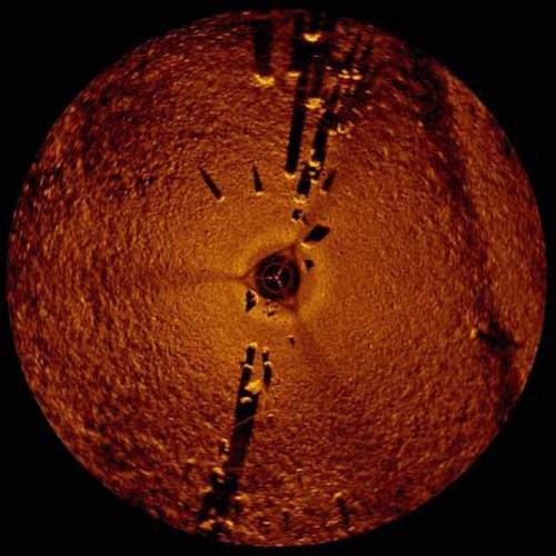
Lake Michigan Stones, photo via bldgblog.

In Stonehenge Beneath the Waters of Lake Michigan, Geoff Manaugh of BLDGBLOG writes:

In a surprisingly under-reported story from 2007, Mark Holley, a professor of underwater archaeology at Northwestern Michigan University, discovered a series of stones – some of them arranged in a circle and one of which seemed to show carvings of a mastodon – 40-feet beneath the surface waters of Lake Michigan. If verified, the carvings could be as much as 10,000 years old – coincident with the post-Ice Age presence of both humans and mastodons in the upper midwest.

Regarding the slightly repurposed “sector scan sonar” device that Northwestern Michigan University College professor and underwater archaeologist Dr. Mark Holley & Brian Abbott were using to survey some old wrecks when they made their discovery, Geoff writes:

The circular images this thing produces are unreal; like some strange new art-historical branch of landscape representation, they form cryptic dioramas of long-lost wreckage on the lakebed. Shipwrecks (like the Tramp, which went down in 1974); a “junk pile” of old boats and cars; a Civil War-era pier; and even an old buggy are just some of the topographic features the divers discovered.

You’ll definitely want to click through to read the rest and see more pictures!

You can read a detailed feature about this in U.S. archeologists find possible mastodon carving on Lake Michigan rock at NowPublic and listen to some radio reports from the time of the discovery in August of 2007 that include an interview with Dr. Holley and another with Grand Traverse Bay Ottawa Indian tribal member and historian John Bailey in Mammoth discovery beneath Grand Traverse Bay? on Absolute Michigan.

Sailing into 2009

Sailing

Sailing, photo by gh patriot.

I thought it was pretty neat that this photo showed up in the Absolute Michigan pool after yesterday’s post. Be sure to check it bigger. It’s part of Kevin’s pier/sunset set (slideshow)

As 2009 dawns, I feel some trepidation. While things have been bad for us here in Michigan, there seems to be little doubt that our national economy has even further to fall. What that might mean to us is anybody’s guess.

One thing I do know is that after years of being in a “single state recession,” we now have company. That will undoubtedly mean less assistance in some cases, but it will also open up more opportunities and solutions as other states and nations begin to grapple with the issues we have been wrestling with.

I expect that in the year to come we in Michigan will make decisions that will have profound effects on our state’s educational system, our infrastructure and our amazing natural resources.

My most profound hope is that our decisions take into account the truth that Gov. Milliken referred to below.

The truth is that the quality of life in Michigan depends on nature. The natural beauty of our state is much more than a source of pleasure and recreation. It shapes our values, molds our attitudes, and feeds our spirit … in Michigan, our soul is not to be found in steel and concrete, or sprawling new housing developments or strip malls. Rather it is found in the soft petals of a trillium, the gentle whisper of a headwater stream, the vista of a Great Lakes shoreline, and the wonder in children’s eyes upon seeing their first bald eagle. It is that soul that we must preserve.

-Michigan Governor William G. Milliken
from William G. Milliken: Michigan’s Passionate Moderate

Happy New Year folks!

frozen in motion: Michigan Winter Wallpaper Page

frozen in motion

frozen in motion, photo by Where’s Walden?.

This is part of Megan’s excellent Michigan Meanderings set (slideshow) and you can see some other sweet photos of ice she’s taken.

The blizzard howling out my window says to me that it’s time to shovel out the Michigan Winter Wallpaper page!

Michigan Winter Wallpaper Page

Old Mackinac Point Lighthouse – Mackinaw City

Mackinac Point Lighthouse at sunset

Mackinac Point Lighthouse at sunset, photo by the pentax hammer.

Gary asks that you please view this the way it should be viewed: Large On Black. See this photo (and many more) larger in his Junk on Explore slideshow.

On his Seeing the Light entry for Old Mackinac Point Lighthouse, Terry Pepper writes that as the connecting passage between Lake Michigan and Lake Huron, the Straits of Mackinac have always been critical to maritime commerce. As the Straits are frequently shrouded with fog, Mackinac Point was an ideal location for a fog signal building and lighthouse and an effort to build a facility began in 1888 and was completed with the installation of a red Fourth Order Fresnel lens in 1892:

As the use of automobiles became increasingly widespread in the early 1900’s, Midwesterners began to take increasing advantage of the newfound freedom that their automobiles provided, driving ever increasing distances to vacation. The unspoiled beauty of Michigan’s Upper Peninsula beckoned, and regular car ferry service began to ply the waters between Mackinaw and St. Ignace. With large amounts of vessel traffic now moving through and across the Straits, the Old Mackinac station became increasingly important as the light enabled the car ferries to operate throughout the night.

When the Mackinac Bridge opened in 1957, the car ferries were out of business, and with the brightly illuminated bridge serving as a navigation aid par excellence, the old light station was immediately rendered obsolete and was decommissioned.

The facility is now part of Mackinac Island State Historic Parks, and you can visit their Old Mackinac Point Lighthouse pages for history of the light and some great old photographs and educational resources for kids.

100 years of Lake Michigan at South Haven Pier Lighthouse

Late October on Lake Michigan

Late October on Lake Michigan, photo by micstolz.

Michael notes that even 100 years of Lake Michigan waves can’t put out the South Haven Light. He has several more in his South Haven Oct 26 2008 set (slideshow) – all uploaded “background big”. You might also want to check out the South Haven Light slideshow from the Absolute Michigan pool.

Terry Pepper’s Seeing the Light relates the history (with photos) of the South Haven Pier Lighthouse. He writes that a Fifth Order Fresnel lens from Parisian glass makers Barbier and Fenestre was installed in the lantern in 1902:

While the light was new, the old wooden beacon had withstood thirty years of Lake Michigan’s worst, and as a result of increasing deterioration, Eleventh District engineer James G. Warren laid-out plans to replace the venerable structure with a new cylindrical metal tower.

Contracts for the metalwork and required materials were awarded and delivered to the lighthouse depot in St. Joseph. On October 6, 1903, the tender Hyacinth delivered the prefabricated steel tower and a work crew on the pier, and erection of the new structure continued through the remainder of the month. The thirty-five foot structure was given a gleaming coat of white paint, and the district lampist carefully removed the Fifth-order lens from the old beacon and installed it in the new octagonal lantern. Captain Donahue proudly climbed the spiral stairs within the new tower to exhibit the South Haven light from atop the new tower for the first time on the evening of November 13.

Light and tower remain an active aid to navigation maintained by the Coast Guard and while you’re in South Haven, be sure to visit the Michigan Maritime Museum.

Michigan is Wine Country

Wine Country, photo by smiles7

Last night I had dinner with a writer from England who is exploring vineyards in Leelanau by bicycle for a story. He was asking me some questions about how Michigan ranks nationally in grape & wine production. I didn’t have all the answers, but fortunately there’s the great Michigan Wines web site from the Michigan Grape & Wine Council.

From their fast facts page, I learned that Michigan has about 1,800 acres of wine vineyards, making Michigan the eighth largest in wine grape producer in the nation (if our juice grapes are factored in, we’re 4th largest). We’ve increased our vineyard area over 60% in the last 10 years. Michigan is 13th in wine production with 56 commercial wineries that produce over 425,000 cases of wine annually. The state’s wineries are also popular tourist destinations, attracting more than 800,000 visitors annually.

Most of Michigan’s quality wine grapes grow within 25 miles of Lake Michigan. Here, the “lake effect” protects the vines with snow in winter, retards bud break in spring helping avoid frost damage, and extends the growing season by up to four weeks.

Michigan has four federally approved viticultural areas (AVAs). In the northwest part of the state, near Traverse City, lie the Leelanau Peninsula and the Old Mission Peninsula. This area has a growing season averaging 145 days and an average heat accumulation of 2,350 growing degree days; 51% of Michigan’s wine grapes grow here. In the southwest part of the state lie the Lake Michigan Shore and Fennville appellations, where 45% of Michigan’s wine grapes are grown. This area has a growing season averaging 160 days and an average heat accumulation of 2,750 growing degree days.

You’ll also want to check out their history page for the very interesting story of Michigan’s winemaking history. Here’s the vineyard slideshow from the Absolute Michigan pool and you can get lots more features and links for Michigan wines from Absolute Michigan.

Holding the sun

Holding the sun

Holding the sun, photo by krowla.

…for just a little bit longer.

Waterspouts on the Great Lakes

Waterspout from Oval Beach in Saugatuck, photo by Jim Thias

I’m not sure where exactly I should link to for Jim, so here’s his great pictures on railpictures.net.

The archived article on Waterspouts on Lake Michigan – where I found this photo – from NOAA’s National Weather Service Weather Forecast Office in Grand Rapids has a number of photos taken from Holland & Saugatuck on September 29, 2006. They explain that:

Waterspouts are somewhat common over the Great Lakes in the Fall season. Waterspouts in the fall occur when colder air above the surface moves over the still relatively warmer waters of Lake Michigan. Most waterspouts that occur in this type of scenario typically occur under plain showers and are much weaker than their summer counterparts. This fall type of waterspout is different from waterspouts associated with thunderstorms. They also form differently than waterspouts associated with thunderstorms.

The National Weather Service in Gaylord has a lot more about the science behind waterspout formation that includes a kicking photo of a group of spouts over Lake Huron in the fall of 1999. They say that boaters should take waterspouts seriously and seek immediate shelter when they are forecast. Waterspouts come in two types: tornadic and fair weather.

Tornadic waterspouts generally begin as true tornadoes over land in association with a thunderstorm, and then move out over the water. They can be large and are capable of considerable destruction. Fair weather waterspouts, on the other hand, form only over open water. They develop at the surface of the water and climb skyward in association with warm water temperatures and high humidity in the lowest several thousand feet of the atmosphere. They are usually small, relatively brief, and less dangerous. The fair weather variety of waterspout is much more common than the tornadic.

You can get a lot more great photos in a search for waterspout on the WOOD-TV blogs. I guess I can link over to this waterspout feature on Leelanau.com that includes my own photo of some waterspouts over the Manitou Islands.

Menominee North Pier Light

Menominee Michigan Lighthouse

Menominee Michigan Lighthouse, photo by Lara Salonen.

You can see more photos of this cool pier light (and see them bigger) in Lara’s Menominee slideshow.

Terry Pepper’s page on the Menominee North Pier Light (at the mouth of the Menominee River on Green Bay) says that after harbor improvements were completed in 1927:

… a prefabricated octagonal cast iron tower was delivered by vessel, and lowered onto the pier.

Click to view enlarged imageThe thirty-four foot tower was painted white, and integrated with an attached fog signal building. An elevated wooden catwalk stretched along the wooden pier to provide the keepers with safe access to the light during periods when waves crashed across the surface of the pier. The octagonal cast iron lantern room was outfitted with a Fourth Order Fresnel lens of unknown manufacture.

At some point thereafter, the wooden pier was replaced by a concrete structure with a forty-foot diameter circular crib at its offshore end. At this time, the fog signal was eliminated with the inclusion of an automated electrically operated signal in the tower. With automation of the light in 1972, the need for daily maintenance of the light was also eliminated, and the iron catwalk was removed from the pier.

Dave Wobster’s page on the Menominee Light has some great photos and says that the 10-sided lantern no longer contains the original Fourth-Order lens, which has been moved to the restored Sand Point Lighthouse in Escanaba.

Big Sable Point Lighthouse in Ludington State Park

Big Sable Point Lighthouse

Big Sable Point Lighthouse, photo by photoshoparama.

Dan has a number of photos from Big Sable Point Lighthouse and you can see them bigger by checking out the slideshow.

Terry Pepper’s Seeing the Light is down (I fervently hope temporarily) so I can’t get the crunchy details on from his Big Sable Lighthouse page. Wikipedia’s Big Sable Point Lighthouse entry says that the historical marker reads:

Called Grande Pointe au Sable by French explorers and traders, Big Sable Point was an important landmark for mariners traveling a treacherous stretch of Lake Michigan shoreline between Big Sable Point and present-day Ludington. In 1855, twelve ships wrecked in that area. Commerce linked to the burgeoning lumber industry required that Big Sable Point be suitably lighted. State senator Charles Mears pressed the legislature to ask the federal government for a light station at Big Sable. In 1866 the U.S. Congress appropriated $35,000 for a lighthouse, which was built the following year. As the lumbering era waned, steamers carrying coal, foodstuffs, and tourists continued to rely on the lighthouse for navigation.

The Big Sable Point Lighthouse is one of the few Michigan lights with a tower reaching 100 feet. Completed in 1867, Big Sable’s tower measures 112 feet high. In 1902 the deteriorating brick tower was encased in steel. The keeper’s dwelling, which once housed a single family, has been enlarged over the years, resulting in the present three-family residence. Indoor plumbing and heating and a diesel electric generator were added in 1949. In 1953, power lines were extended to the Point. In 1968 the tradition of light-keeping begun in 1867 by Alonzo A. Hyde and his wife, Laura, ended when the station was fully automated. Big Sable Point Light Station is listed in the National Register of Historic Places.

The light is located in Ludington State Park (Wikipedia) and is open for tours May – October (see bigsablelighthouse.org for details). The Sable Points Lighthouse Keepers Association maintains several lighthouses on the east coast of Lake Michigan: Big Sable, Ludington North Breakwater, and Little Sable.

For more views of the lighthouse and the area, check out Big Sable Point on Flickr, some Big Sable Point Lighthouse panoramas (go to full screen!) and these rocking aerial photos of Big Sable Lighthouse at marinas.com – be sure to use the zoom!

You can check out Big Sable Point Lighthouse on the Absolute Michigan map (satellite view).