Ice Machine: How Shoreline Ice Forms on the Great Lakes

Lake Michigan Ice by Tim Wenzel

Snowball Fight Anyone?, photo by Timothy Wenzel

One of my favorite photo blogs is the Earth Science Picture of the Day from NASA. In Wednesday’s blog, Timothy wrote:

This photo, taken on January 24, 2013, illustrates how ice on Lake Michigan’s eastern shore can achieve heights of many feet; by accretion of floating snowball-size ice balls thrown upward by wave action. The maximum wave height (crest to trough) on Lake Michigan on this day was approximately 6 ft (2 m). What results is a landscape that looks almost volcanicClick here to see video of this phenomenon. Note that the lake itself is a slurry of ice and water.

Definitely check Tim’s video out! See the photo background bigtacular and see more in Timothy’s work including more photos from the day in his Weather Underground gallery.

More EPOD awesomeness on Michigan in Pictures!

Ice Kingdom

DSC08043RP

DSC08043RP, photo by Scott Glenn

Incredible what wind, water and way too cold can do! More about the St. Joseph lighthouse on Michigan in Pictures.

Check this out on black and see more icy goodness in Scott’s lighthouse slideshow.

Ludington Lighthouse, with chocolate and whipped cream

lighthouse with chocolate and whipped cream

Lighthouse with chocolate and whipped cream, photo by Craig Sterken Photography

Craig shared this photo of the North Breakwater Pier and Lighthouse in Ludington on the Absolute Michigan Facebook the other day.

See it bigger on Facebook and see more on the Craig Sterken Photography Facebook page or at craigsterken.com!

More shots of  Ludington (and this lighthouse) on Michigan in Pictures.

Great Lakes water levels: Then & Now Edition

"... is the Lake Michigan water level low?" ...

“… is the Lake Michigan water level low?”, photo by Ken Scott

This photo is from a feature on today’s Leelanau.com blog about the historic water lows on the Great Lakes. It includes a great video so definitely check it out.

Leland is my home town and to see the difference from just 27 years is astonishing!

See it bigger, view more in Ken’s massive Leland/Fishtown slideshow and read an extensive discussion on Facebook.

More Lake Michigan on Michigan in Pictures.

Great Lakes Ice at near-record lows

Winter 2011 - Lake Ice

Winter 2011 – Lake Ice, photo by danbruell

The Great Lakes Echo reports that:

composite map of the Great Lakes produced by NOAA’s CoastWatch organization shows near-historic low ice coverage across the region.

The map, known as the Great Lakes Surface Environmental Analysis, is a composite of data taken from NOAA satellites orbiting the earth’s poles and radar scans of the lakes by the National Ice Center. The resulting image shows surface water temperature and ice coverage, important data for region scientists, fishermen and boaters. The map’s data is updated daily.

“Previously, the lowest ice coverage year was 2002,” CoastWatch manager George Leshkevich said. “2012 came very close to 2002, and this year is looking very similar to last year.”

Lack of ice cover leads to increased water evaporation, a serious concern in light of already-low lake levels.

You can read more about last year’s ice cover and impacts on Absolute Michigan.

Check Dan’s photo out background bigtacular and see more in his Lake Ice slideshow.

More winter wallpaper on Michigan in Pictures!

Low water exposes Grand Haven shipwreck graveyard

Grand Haven Shipwrecks

Grand Haven Shipwrecks, photo by Kevin Ryan

mLive has a feature on how our historically low water levels have revealed a number of shipwrecks in Grand Haven:

Maritime archaeologist and director of the Tri-Cities Historical Museum Kenneth Pott said the area around Harbor Island was an apparent dumping zone for abandoned vessels and 1930s aerials held by the museum and the city of Grand Haven show that additional wrecks exist there. If the water line were to recede even more, then more vessels may be exposed.

“We’re quite sure that there are more in the area,” Pott said. “This is something akin to a graveyard for vessels. This is very unusual.”

The wooden sections of the 290-foot steamer Aurora, once the largest wooden steamer on the Great Lakes, and parts of at least four other shipwreck hulks were exposed recently by the low water levels and area residents alerted maritime historians to the find. The Aurora was identified by members of Holland-based Michigan Shipwreck Research Associates and local historians earlier this week.

Read on for more info including the publicly-accessible location. You can also read more about the Aurora right here and see a photo gallery.

Check this out background big and see a couple more views including a nice one of the rough outline of the wreck in Kevin’s slideshow.

More Michigan shipwrecks on Michigan in Pictures.

Dream on

Dream On

Dream On, photo by Unified Photography

I can’t make sense of what happened yesterday at Sandy Hook Elementary School and have nothing to say other than that my thoughts and prayers are with these families and all of us.

Get this photo background big and view more in Kenneth’s Sleeping Bear Dunes slideshow.

Lake Michigan

Lake Michigan

Lake Michigan, photo by karstenphoto

Check this out background bigtacular and see more in Steve’s Film! slideshow.

More black & white photography and more Lake Michigan from Michigan in Pictures.

The Armistice Day Storm of 1940

Chipping ice from the City of Flint

Chipping Ice on the City of Flint, photo by Captain John Meissner

Wikipedia explains that the Armistice Day Blizzard struck November 11  (Armistice Day) and November 12, 1940. The intense early-season “Panhandle hook” winter storm cut a 1,000-mile-wide path through the middle of the country from Kansas to Michigan.  Carferries.com has a great article on The Armistice Day Storm of 1940 that begins:

The “storm” of November 11, 1940 was one of the worst storms in the recorded history of Lake Michigan. In all, the storm claimed 5 vessels, and 66 lives. The storm occurred on Armistice Day, which celebrated the end of World War I in 1918.

The storm hit late Monday afternoon, November 11th, with winds of hurricane proportions. The winds struck suddenly from the southwest at about 2:30 P.M. and were accompanied by drenching rain, which later changed to snow. The winds reached peak velocities of 75 miles per hour, the highest in local maritime history. Telephone and power lines were down by the hundreds around Mason County. Several local firms had “gaping” holes where roofs once were. Trees were uprooted, small buildings were overturned, and brick walls were toppled, causing at least 1 serious injury. Very few places escaped without damage. Ludington, on the morning of November 12th, appeared to be a deserted city.

The Pere Marquette carferry City of Flint 32, attempted to make the harbor but wound up on the beach about 300 yards from the shore. She was ordered by her relief captain, Jens Vevang, to be scuttled to avoid being pounded by the incoming seas. On November 12th, a breeches buoy was strung and 27 year old crewman Ernest Delotowski of 406 First Street, Ludington, was brought ashore. Delatowski made a good portion of the trip in the icy waters of Lake Michigan. As a precautionary measure, he was taken to Paulina Stearns Hospital and was released later that day. He said he carried a message with him, but it got lost in the water. Later the buoy was used to carry a message to the ship, and then crewman Luther Ryder of S. Washington Avenue (Ludington) was brought ashore.

You can read more including first-hand recollections of the storm and also see more photos taken by Captain John Meissner and also photos of the grounding and other wrecks as a result of the storm at carferries.com.

More shipwrecks on Michigan in Pictures.

The Strongest Storm Ever on the Great Lakes

"October Gale" Grand Haven lighthouse, Grand Haven Michigan

“October Gale” Grand Haven lighthouse, Grand Haven Michigan, photo by Michigan Nut

As the eastern seaboard braces for Hurricane Sandy, a storm of possibly unprecedented power, I thought I’d take a look back and see what the strongest October storm ever was. I didn’t have to look far, as it’s actually the Great Lakes storm of late October 2010:

On October 26, 2010, the USA recorded its lowest pressure ever in a continental, non-hurricane system, though its pressure was consistent with a category three hurricane. The powerful system was dubbed the “Chiclone” by the media as it hit the Chicago area particularly strongly, as well as Minnesota, Wisconsin and Michigan. It was also meteorologically referred to as a bombogenesis due to the rapid drop of barometric pressure experienced.

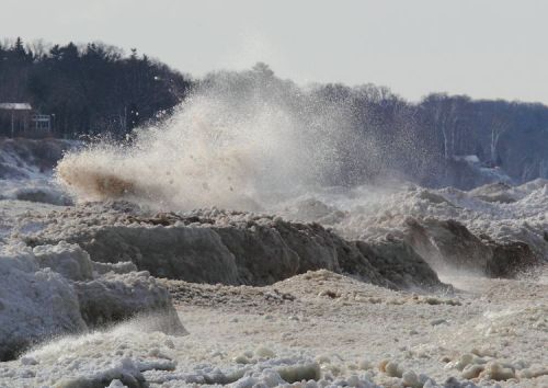
…The storm also produced some of the highest officially recorded waves by weather buoys stationed in Lakes Superior and Michigan. Specifically, on Wednesday, October 27, 2010, buoy no. 45136, operated by Environment Canada, in northern Lake Superior recorded a significant wave height of 26.6 feet (this is average height of 1/3 of the highest waves over an hour), and buoy no. 45002, operated by the National Data Buoy Center (NDBC), recorded a significant wave height of 21.7 feet in northern Lake Michigan. The NDBC and many models indicate that multiplying significant wave height by a factor of approximately 1.3 will equal the approximate average height of the highest 1/10 of waves recorded -here that would translate into such average wave heights of approximately 34.5 feet and 28.2 feet on Lakes Superior and Michigan respectively [please verify]. This would appear consistent with the NOAA forecast for northern Lake Michigan calling for 21-26 foot waves that day. The persistence and strength of the storm’s westerly winds also piled the waters of Lake Michigan along the Michigan shoreline leading to declines in lake levels on the Illinois and Wisconsin side of the lake. Based on NOAA lake level sensors, an updated analysis of Wednesday, October 27, 2010 water levels on Lake Michigan revealed a two-day decrease of 42 inches at Green Bay, WI and 19 inches at Calumet Harbor, IL—while NOAA sensors at Ludington, MI and Mackinaw City, MI measured lake level rises of 7 and 19 inches respectively.

A 78 mph gust was recorded the afternoon of October 27, 2010 at the Harrison-Dever Crib, three miles offshore of Chicago in Lake Michigan.

You can read a detailed account of the damage in the October North American Storm Complex on Wikipedia and also read Dr. Jeff Masters’ analysis of the storm at Weather Underground.

Check this out on black and see more in John’s Grand Haven Lighthouse slideshow.

More Michigan weather on Michigan in Pictures.