

Lake Michigan clouds, photo by karstenphoto
Gotta love film.
View Steven’s photo background big, in his Lake slideshow and see more of his work on Michigan in Pictures.
Lake Michigan clouds, photo by karstenphoto
Gotta love film.
View Steven’s photo background big, in his Lake slideshow and see more of his work on Michigan in Pictures.
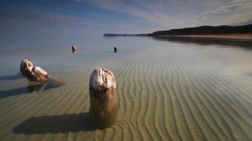
Spring on Good Harbor Bay, photo by Eric Raymond
Good Harbor is located on the northern edge of Sleeping Bear Dunes National Lakeshore at the Lake Michigan end of County Road 651. Today only evidence of the vanished village are the pilings of what was once a 500′ dock that could load 4 schooners at a time. The Good Harbor page from the Lakeshore explains that logging in the area began in 1863 to supply cordwood fuel for steamers, leading to the founding of a village in the 1870s.
Shortly after 1880 (Henry) Schomberg bought out Schwartz’s interest and built a big sawmill which had a capacity of 30,000 feet in a 10-hour day.
…The Schomberg Lumber Company ran a hotel, two stores which became a shopping center for the local farmers, and a saloon. The township line between Centerville and Cleveland townships ran down the middle of Main Street in Good Harbor. Centerville did not allow saloons, so Good Harbor’s saloon was built on the Cleveland township side of the street … At the height of the lumber business, the mill worked day and night during the winter and during the day in the summer. As many as 75 teams of horses were used hauling logs to the mill, lumber to the dock, and supplies to the camps. The lumber company owned some of the teams and the rest were owned by local farmers and rented to the lumber company. At its peak, the mill cut 8,000,000 board feet of lumber per year.
The schooners were loaded by farmers who were called to work at the dock when the ships arrived. Good Harbor had no protection from storms with a northwest wind, so ships had to leave the dock and sail to the Manitou Islands for protection when a storm would come up. Sometimes storms would come up too fast and the ships were driven aground.
You can read on for more and also see some of the wrecks in the area in the Manitou Passage Underwater Preserve.
Check this out bigger and see more great photos from the Sleeping Bear and Leelanau Peninsula (including another shot of the pilings by Terry Clark) on Eric’s Leelanau County Facebook page.

As the air heats up we will get these warm and wave-tossing winds in the Great Lakes. The Chicago Tribune explains why spring brings us stronger lake breezes, the coastal wind that blows from the lake to land:
It’s powered by differences in density between warm (less dense) air over land and cool (more dense) air over Lake Michigan. Because temperature greatly affects air density, a lake breeze is most likely to form (and it will blow most strongly) when large temperature differences exist between the “land air” and “lake air.” Those temperature differences are greatest in April and May when the lake air is chilly because Lake Michigan waters still retain much of winter’s cold and the land air is warming strongly in response to the strengthening spring sun.
Check this photo from last April near Muskegon out big as the Big Lake and see more in Jben’s Sunsets on Lake Michigan slideshow. It’s also the cover of the Michigan in Pictures Facebook!
More spring wallpaper on Michigan in Pictures and also lots more cool wind photos!

Locally Known as “the Bowl”, photo by karstenphoto
EDIT: Wow I really messed this one up, sleepily citing an article that gave the dune’s age in the millions of years. Thanks to Tom Burrows for the catch. Let’s see if this information on coastal dunes from the DNR makes more sense:
Michigan’s glacial history provides an explanation for the formation of dunes. The Great Lakes dune complex is relatively young, in terms of geological time. As recently as 16,000 years ago, Michigan was covered with glacial ice thousands of feet thick. This glacial ice contained a mix of boulders, cobbles, sand, and clay. During glacial melting, this deposit was left and is known as glacial drift.
This glacial drift is the source of sand in most of Michigan’s dunes. The sands were either eroded from glacial drift along the coast by wave activity or eroded from inland deposits and carried by rivers and streams. Only the hardest, smallest, and least soluble sand grains were moved. Waves and currents eventually moved these tiny rocks inland, creating beaches along the Great Lakes shoreline.
…Blowouts are saddle shaped or U shaped (parabolic) depressions in a stabilized sand dune, caused by the local destabilization of the dune sands. Blowouts, which originate on the summit or windward face of a dune, are often rapidly formed by the wind, creating narrow channels and exposing plant roots. Blowouts can create interruptions in the shape of parallel dunes that may result in deeply carved indentions called parabolic dunes. It is the combination of interwoven parallel dune ridges and U shaped depressions, including parabolic dunes, that characterizes the classic dunes from Indiana, northward to Ludington, in Michigan.
Awesome Michigan wrote a little about The Bowl at Holland saying:
The Bowl is an gigantic sand bowl, resembling a sort of concave desert.
Along with the other dunes and Lake Michigan itself, The Bowl was carved out of the earth by glaciers millions of years ago and was likely a small lake before drying up.Standing at the center of The Bowl and being surrounded on all sides by enormous walls of sand is quite breathtaking. The landscape is truly like no other. This awesome sight alone makes a trip to Laketown a summer necessity and a great, relaxing place to bring friends and family.
You can also check in there on Foursquare. Here’s another shot from the bowl from all the way back in 2007. Amazing to me how long Michigan in Pictures has endured – thank you all for staying with me!
Check Stephen’s photo out big as the Bowl and see this and many more in his FILM! slideshow.
More dunes on Michigan in Pictures.

“Lake Michigan Overlook” Pierce Stocking Scenic Drive, photo by Michigan Nut
The other day on Leelanau.com I posted Sequestration and the Sleeping Bear Dunes detailing cuts that will be made at the Sleeping Bear Dunes National Lakeshore to meet their 5% budget requirement. The Pictured Rocks National Lakeshore, Isle Royale and the Keweenaw National Historical Park will all be forced to trim budgets as well. Due to the fact that the NPS fiscal year ends in September, the cuts end up being closer to 10% than 5%.
All of the officials quoted stress that the parks remain open and (mostly) accessible, but when Michigan is spending millions of dollars promoting Pure Michigan nationwide with these parks at the center of our offerings, there’s no question that this is bad news for tourism!
John took this photo about a year ago – view it bigger and see more in his Sleeping Bear Dunes National Lakeshore slideshow. He is a frequent guest on Michigan in Pictures – view more of his posts right here.

Good Hart Iceberg, photo by Molly Baker/The Outfitter
“This year we have been fortunate enough to have cold weather, lots of wind, and combined it builds ice into ice caves, ice mountains.”
~Jim Sutherland, Good Hart General Store Owner
Winter 2013 sure has been dishing up some amazing ice including the ice boulders along the Sleeping Bear shore. UpNorthLive reports on the latest a Lake Michigan iceberg floating offshore at Good Hart north of Harbor Springs.
“It was just a bunch of blocks piled on top of each other and they were welded together with the wind and snow,” Outdoor enthusiast Josh Baker explained.
Over the weekend, Baker and his family stumbled across this giant island floating in Lake Michigan outside of the small town of Good Hart.
Sunday, he decided to climb the jagged, 15-foot ice mountain. Once he made it to the top, he noticed the structure was different on the other side.
“The side facing the lake was almost sheer, it was pretty neat. So the side I was on was all jumbled and the opposite side was just sheer down to the water,” Baker said.
Click through to watch the report!
Check this out bigger on Facebook or scroll through their whole gallery. If you want to visit Molly & Josh for a first-hand account, their store is The Outfitters in Harbor Springs.
More ice on Michigan in Pictures!

ice field, photo by northernlightphotograph
Check this out on black, see more from Tim on Michigan in Pictures and definitely check out his 2013 Winter Ice slideshow.

Lake Michigan Ice Boulders, photo by Leda Olmsted
Todays post is from the “Ain’t it Cool” Department. A couple of weeks ago Leelanau County resident Leda Olmsted was walking the Lake Michigan shore in the Sleeping Bear Dunes National Lakeshore when she came across this incredible scene. TV 7&4 reports in Ice boulders roll onto shores of Lake Michigan that Leda took some photos, uploaded to the news station’s Facebook and:
Leda says she was shocked by the response. Olmsted explains, “From there it got like 800 shares and thousands of likes and overnight I had Good Morning America and The Weather Channel calling me, so it has been a really crazy weekend!”
Deputy Superintendent from the Sleeping Bear Dunes National Lakeshore Tom Ulrich says, “It’s not that it never happens and this is a once in a decade thing, it happens more often than that, but these are very large and got bigger than they normally get.”
The ice balls or boulders along the shores of Lake Michigan are about the size of giant beach balls or basketballs and weigh up to 50 pounds.
Click to watch the video from UpNorthLive with Leda.
I looked a little further into the phenomenon and found and AIR PHOTO INTERPRETATION OF GREAT LAKES ICE FEATURES by Ernest W. Marshall in the Great Lakes Digital Library at the University of Michigan. With the help of Marshall’s information, here’s an explanation of how ball ice forms:
Ball ice consists of roughly spherical masses of slush and frazil ice that accrete in turbulent water. Frazil ice (via Wikipedia)is a collection of loose, randomly oriented needle-shaped ice crystals that form in open, turbulent, supercooled water. Lumps that form in the less turbulent zones are typically flattened discs, while those formed in the extremely turbulent zone near the shoreline ice where wave action is strongest form into spheres.
The author explains that ball ice is a feature common to all of the Great Lakes and can occur at any time during the winter where water turbulence breaks up a slush layer. You can read more about this in Great Lakes Ice Features.

Valentine Ice, photo by Happyhiker4
Happy Valentine’s Day to everyone and here’s hoping that love finds its way into your day and life!
Check Mark’s photo out on black and see more magical winter shots on Mark’s Facebook!
View past Valentines Days on Michigan in Pictures.

Low water levels, West Arm Grand Traverse Bay, photo by michiganseagrant
On Michigan in Pictures I usually blog beautiful things, but today I’m featuring an ugly thing that we in Michigan should all be concerned about. Traverse City based Circle of Blue has an in-depth feature on the record-low level of Lake Michigan-Huron:
The latest numbers released by the U.S. Army Corps of Engineers on February 5 show that both lakes Michigan and Huron — which are two connected lakes — are experiencing their lowest point since records began in 1918. Water levels were an average of 175.57 meters (576.02 feet) for the month of January, approximately 2.5 centimeters (1 inch) lower than the previous record set in 1964.
“Not only have water levels on Michigan-Huron broken records the past two months, but they have been very near record lows for the last several months before then,” said John Allis, chief of the Great Lakes Hydraulics and Hydrology Office at the Corps, in a press release. “Lake Michigan-Huron’s water levels have also been below average for the past 14 years, which is the longest period of sustained below-average levels since 1918 for that lake.”
The low water levels, which the Corps attributes to: below-average snowfall during the winter of 2011-2012, last summer’s drought, and above-average evaporation during the summer and fall of 2012, have the potential to hurt the Great Lakes’ shipping industry.
…For the water levels on Lake Michigan-Huron to reach even near-average water levels again, the Corps said it will take many seasons with above average precipitation and below-average evaporation.
Read on at Circle of Blue for much more including the struggles that wildlife are having with the changing climate. You can also view the release from the Army Corps of Engineers and see historic Great Lakes levels back to 1918. From the Army Corps, I learned that at 1 1/2 ft below normal, ships are losing 8-10% of their carrying capacity.
Beyond harm to the multi-billion dollar shipping industry which feeds countless industrial endeavors, the low lake levels are making many of our recreational harbors inaccessible. These feed our multi-billion dollar sport fishing industry and this has prompted Gov. Snyder to endorse a $21 million emergency dredging plan, $11 million of which would come from Michigan’s general fund. With over a half a million jobs in Michigan alone tied to the health of the Great Lakes, getting a handle on the threats that impact them are likely to be at the center of our policy and spending for a long time.
In a curious bit of synchronicity, you can see just how vital the Great Lakes are to Michigan in Michigan Sea Grant’s reports on Economic Vitality and the Great Lakes. View this photo bigger and see more in their Grand Traverse Bay Low Water slideshow.
Lots more Lake Huron and Lake Michigan on Michigan in Pictures.
