Pure Michigan Picnic: April Edition

Pure Michigan Picnic April 2016 Edition

Nice Day for a Picnic, photo by mileelanau

I don’t usually post my own photos on Michigan in Pictures, but I felt I had to share this one from Sunday. Pure Michigan! …yay??

mileelanau is the Instagram for my “flagship” Leelanau.com, and where I post pictures from hiking around northern lower Michigan. Follow mileelanau on Instagram for more.

PS: This turned out to be the picnic table of some old family friends. Loved discovering that on Facebook!! ;)

PPS: More beach and more Lake Michigan photos on Michigan in Pictures.

Whipped Up Waves for the Weekend!

Whipped Up

Whipped Up, photo by Terry Clark

mLive reports that big waves are expected for parts of Lake Huron and Lake Michigan this weekend:

High winds and an arctic air mass are set to hit Michigan this weekend, and gales are in the forecast for the Great Lakes as a result.

A gale warning for much of Lake Huron’s offshore waters, issued by the National Weather Service, is scheduled for 8 p.m. Saturday, April 2 to 5 a.m. Sunday, April 3.

Winds are expected to reach up to 41 mph from the northwest with gusts up to 53 mph. According to the warning, waves will build up to 13 feet tall with the potential for an occasional 19-footer. The largest waves in an area 5 nautical miles off shore and out are expected around 1 a.m. Sunday on Lake Huron.

If you want to tune in, check out NOAA’s Great Lakes Coast Watch and the Great Lakes Webcam page.

View Terry’s photo background big and see more in his Wintry Scenes slideshow.

More waves and more wild weather on Michigan in Pictures!


Spectacular Display on the Grand Haven Pier

Spectacular Display

Spectacular Display, photo by Bob Gudas

Bob took this shot of a photographer on Grand Haven’s North Pier with more guts or maybe less sense than most. I bet his photo was pretty sweet though!

View it bigger and see more in his slideshow.

Making the Leap

Leaping off Pyramid Point

Untitled, photo by Todd Richter

Happy Leap Day everyone and here’s hoping that this quadrennial occurrence adds a little fun to your life! Borgna Brunner lays down Leap Year 101:

Leap years are added to the calendar to keep it working properly. The 365 days of the annual calendar are meant to match up with the solar year. A solar year is the time it takes the Earth to complete its orbit around the Sun — about one year. But the actual time it takes for the Earth to travel around the Sun is in fact a little longer than that—about 365 ¼ days (365 days, 5 hours, 48 minutes, and 46 seconds, to be precise). So the calendar and the solar year don’t completely match—the calendar year is a touch shorter than the solar year.

It may not seem like much of a difference, but after a few years those extra quarter days in the solar year begin to add up. After four years, for example, the four extra quarter days would make the calendar fall behind the solar year by about a day. Over the course of a century, the difference between the solar year and the calendar year would become 25 days! Instead of summer beginning in June, for example, it wouldn’t start until nearly a month later, in July. As every kid looking forward to summer vacation knows—calendar or no calendar—that’s way too late! So every four years a leap day is added to the calendar to allow it to catch up to the solar year.

Read on for more and enjoy your day.

Todd took this shot back in August of 2009 at one of my favorite spots for hiking (and jumping) – the Pyramid Point overlook in the Sleeping Bear Dunes National Lakeshore. Lake Michigan is hundreds of feet down a steep bluff from the point where she’s jumping, and many is the person who wished they didn’t run down that bluff after toiling up it!

View Todd’s photo background bigtacular and see more in his digital slideshow.

More dunes on Michigan in Pictures!

Quiet Night at Frankfort Lighthouse

Frankfort Lighthouse at Night

Quiet Night at Frankfort Lighthouse, photo by Snap Happy Gal Photography

I was going to talk this morning about how I will continue to talk about what I want to talk about on Michigan in Pictures, but then I saw this awesome photo by Heather. I’m sure you get the idea.

On her Snap Happy Gal blog where you can view & purchase some great lighthouse photos, Heather writes:

I think of myself as a serendipitous shooter: I go out to scenes in all kinds of light – the good, the bad, even the ugly – and I take photos. Sometimes I walk away with artwork worth sharing, and sometimes I just walk away with happy memories. I don’t often stalk a scene for the best light, I don’t think of myself as having a favorite thing to photograph, and I don’t find that I’m predictable (even I don’t know when or where I’ll be heading out to shoot until I get the itch). But, lately, if you wanted to catch me out and about, you’d look at northern Michigan’s west coast lighthouses.

I’ve visited every one of them from Manistee up to Northport (though I didn’t take the camera out), and I’ve been there from sunrise to sunset, and well into the night.

Last Wednesday, I checked the weather and saw something I hadn’t seen in what felt like eons: the possibility for clear night skies. I packed my gear, my cold weather clothes, and food and water, and headed for the coast. I missed the best light in an incredible sunset, but caught the afterglow and the first light of the moon on the lakeshore just south of Empire. While the skies were still cloudy, I headed south into Frankfort to see how the ice was shaping up along the beach. By this time, the winds had died down almost entirely. The water inside the breakwall was very still, the forming ice chattered, and tiny waves sloshed against the icebergs beached on the sand.

Read on for the rest, view & comment on her picture on Facebook, and definitely follow Snap Happy Gal for great pics of lighthouses and much more.

More about the Frankfort North Breakwater Light on Michigan in Pictures.

Why is Ice Blue or Green?

The Blue Ice

The Blue Ice, photo by Charles Bonham

The Causes of Color answers the question: What causes the blue color that sometimes appears in snow and ice?

As with water, this color is caused by the absorption of both red and yellow light (leaving light at the blue end of the visible light spectrum). The absorption spectrum of ice is similar to that of water, except that hydrogen bonding causes all peaks to shift to lower energy – making the color greener. This effect is augmented by scattering within snow, which causes the light to travel an indirect path, providing more opportunity for absorption. From the surface, snow and ice present a uniformly white face. This is because almost all of the visible light striking the snow or ice surface is reflected back, without any preference for a single color within the visible spectrum.

The situation is different for light that is not reflected, but penetrates or is transmitted into the snow. As this light travels into the snow or ice, the ice grains scatter a large amount of light. If the light is to travel over any distance it must survive many such scattering events. In other words, it must keep scattering and not be absorbed. We usually see the light coming back from the near surface layers (less than 1 cm) after it has been scattered or bounced off other snow grains only a few times, and it still appears white.

In simplest of terms, think of the ice or snow layer as a filter. If it is only a centimeter thick, all the light makes it through; if it is a meter thick, mostly blue light makes it through. This is similar to the way coffee often appears light when poured, but much darker when it is in a cup.

Click through for lots more about light & color!

Charles took this photo last March off Gills Pier on the Leelanau Peninsula when there was a whole lot more ice than there is this winter. View it background bigilicious and see more in his Leelanau Peninsula slideshow.

More winter wallpaper and more amazing ice on Michigan in Pictures.

#TBT: Icebound Car Ferries in Ludington

Carferries Icebound in Ludington 1913

Icebound Carferries at Ludington, photo courtesy Karl Bahle

The caption reads “Carferries 15, 17, 18 and 19 – Fast in ice at Ludington, Mich March 22, 1913” and from that, I was able to dig up some tasty history! Carferries.com has great information on the Pere Marquette fleet of ferries that was based in Ludington. They say (in part):

At various times between 1897 and 1947, the Pere Marquette operated a total of 13 ferries on Lake Michigan, running between Ludington, Mich. and Milwaukee, Manitowoc and Kewaunee, Wis. These ships were then an efficient means of bypassing the congested rail yards in Chicago. They plied routes varying between 60 and 97 miles in length, and were often plagued by violent storms and heavy ice. Given the fact that most of the cross-lake runs were made at speeds of 12 to 14 miles per hour, a remarkable volume of freight was carried.

In those fifty years the Pere Marquette car ferries made well over 160,000 lake crossings and transported roughly 4.5 million railroad cars loaded with over 75 million tons of freight. Even these numbers are somewhat conservative, as early records no longer exist. They also carried approximately 1.6 million passengers and after the mid-1920’s, about 380,000 automobiles. Additionally, over the course of its history, the railroad operated a total of 4 river car ferries. These ran between Port Huron, Mich. and Sarnia, Ont., and between Detroit, Mich. and Windsor, Ont., connecting the PM’s Michigan and Canadian lines.

  • Pere Marquette 15 – launched in December of 1896 as the original Pere Marquette. She reportedly burned 30 tons of coal on an 1897 round trip from Ludington to Milwaukee. In 1924, the vessel was renamed Pere Marquette 15, and scrapped in Manitowoc in 1935.
  • Pere Marquette 17 – launched in 1901, hauled 2 “Jack Johnson” battleship guns in 1915, sold to the State of Michigan to be the car ferry “City of Petoskey” <-great info and photos there!
  • Pere Marquette 18 – here’s where the history gets a little murky, as the ship that was launched in 1902 sank in 1910 off Sheboygan, Wisconsin, so either the date is wrong on the photo above or that’s another ship! UPDATE: Karl informed me that the original 18 did sink in 1910, a new one was put into service in 1911 and sailed until 1954!
  • Pere Marquette 19 launched in 1903, ran aground numerous times before being sold for scrap in 1940. She was reduced to a barge profile and renamed the Hilda.

If you’re wondering “What happened to Pere Marquette 16?” that link has great info on the 16, only wooden car ferry in their fleet!

View Karl’s photo bigger and check out his Lake Boats album for many more photos!

Morning Light at the Manistee Pierhead Light

Manistee Lighthouse

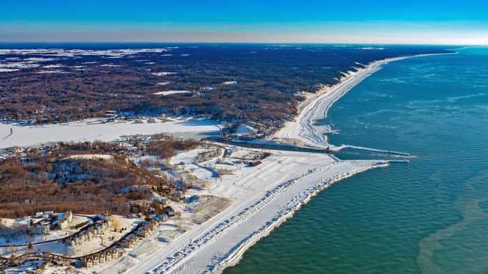
Manistee Morning Light, photo by Heather Higham

Terry Pepper’s Seeing the Light has an extensive entry on the history of the Manistee Pierhead Light with copious information and historical photos. Terry goes deep on Manistee’s history as a lumber port:

Although the first sawmill had been established on the banks of the Manistee in 1841, settlement in the area was not widespread until the Chippewa relinquished their reservation by treaty in 1849, and the federal government offered lands along the Manistee for public sale. It did not take lumber interests long to realize the incredible potential of the Manistee which snaked a hundred miles into the forests, and lumbermen soon began lobbying for federal funding to improve the harbor and to erect a lighthouse at the river mouth. With no appropriation forthcoming, the businessmen of Manistee took the matter into their own hands, erecting a pair of short stub piers at the river mouth in an attempt to stem the deposition of sand and silt.

In 1861, Congress instructed the Army Corps of Engineers to dispatch an Engineer Officer to Manistee to conduct a survey of the river entrance. Water depth in the opening between the piers was found to be from seven to eight feet, and a 250-foot long sand bar with a water depth of less than five feet above it was identified 600 feet off the end of the piers.

…To serve this burgeoning maritime commerce, the piers were extended an additional 150 feet in 1875, and the channel between them dredged to a minimum depth of ten feet. With the main light now standing a considerable distance to the rear of the pierheads, the decision was made to replace the shore light on the north bank with a pierhead beacon on the outer end of the longer south pier. Click to view enlarged image The new south pierhead light consisted of a timber-framed pyramidal beacon typical of the type being erected on pierheads throughout the Great Lakes. With its lower half open, the upper half immediately below the gallery was enclosed to provide a small service room for lamp maintenance. Equipped with windows, the service room also served as a sheltered area in which the keeper could stand watch during inclement weather. Standing 27 feet in height, the beacon was capped with a square gallery with iron handrails and an octagonal cast iron lantern installed at its center.

Read on for a whole lot more.

About the photo, Heather writes:

I still can’t believe I managed to drag myself out of bed this morning. There were 8 minutes of pink light – and a stunning sunrise to the east that I completely ignored – followed by about 90 minutes of interesting (if not sunrise) light.

View it bigger, see more in her Lighthouses slideshow and definitely add Snap Happy Gal Photography to your Facebook follows!

More Michigan Lighthouses and more sweet sunrises on Michigan in Pictures.

Below the Mighty Mac

Under the Mighty Mac

Mighty Mack, photo by vinnywalsh.com

Last week I shared how you can get driven across the Mackinac Bridge. Guessing you’re on your own if you want to cross the Straits of Mackinac at this level!

Vinny took this photo on Christmas Eve of 2005. If you want to check in with the current scene, the Mackinac Bridge Authority webcams have you covered with three different views.

Check his photo out bigger and see more at vinnywalsh.com.

Much more Mackinac Bridge on Michigan in Pictures.

Happy Birthday Holland: Looking back on the Holland Channel

Looking Back on the Holland Channel

Looking Back at the Holland Channel, photo by Sandy Hansen Photography

February 9th is the 169th anniversary of the founding of Holland, Michigan. The History of Holland has some background about one of the prime factors for the city’s success, the Holland Channel:

From its very beginnings, Holland provided a refuge for those seeking freedom of expression and a more vibrant economy. Persuaded by religious oppression and economic depression, a group of 60 men, women, and children, led by Albertus C. VanRaalte, prepared for their 47-day trip from Rotterdam to New York. VanRaalte intended to purchase land in Wisconsin, but travel delays and an early winter caused the group to layover in Detroit. After hearing about available lands in west Michigan, VanRaalte decided to scout the territory. They reached their destination on February 9, 1847 on the banks of Black Lake—today’s Lake Macatawa.

The hundreds of Dutch immigrants that followed expected to find their promised land, but instead found a swamp and insect-infested forest. Although food was scarce, and the log sheds they built were unable to hold everyone, the settlers persevered. VanRaalte realized the practical and economic potential of the dense forest: trees could be felled to build homes and businesses, while the excess lumber could be sold to purchase farming supplies.

In the early years of Holland history, the settlers set out to conquer several projects. They knew that if Lake Michigan was to provide growth and development, it had to be made accessible by an adequate channel. After trying in vain to receive government aid, the determined Hollanders took up picks and shovels and went about digging the channel themselves. The immigrants also cleared a one-block square of land in the center of the colony—today’s Centennial Park—to serve as a market square.

Read on for more and click for a live webcam of the Holland Channel.

View Sandy’s photo bigger, see more in her Aerial slideshow, and follow her on Facebook too!

More aerial photos and more from Holland on Michigan in Pictures.