The Eyes of the Earth

aerial-shot-sandy-hansen-photography

aerial shot, photo by Sandy Hansen Photography

“A lake is the landscape’s most beautiful and expressive feature. It is the earth’s eye; looking into which the beholder measures the depth of his own nature.”
—Henry David Thoreau, Walden

One of Thoreau’s most beautiful thoughts in my mind, and we are certainly blessed in Michigan to have the eyes of the earth upon us here as they are in few other places.

Sandy says that at the top of the photo are West & East Grand Traverse Bay and then Elk Lake and Lake Skegemog. You can get your bearings and have a little fun exploring the lakes from above in this 3d view from Google Earth.

View her photo bigger and see more including more from this February flight in her Traverse City Area slideshow.

More aerial photography on Michigan in Pictures.

High and Dry in the Leland Harbor

high-and-dry

High and Dry, photo by Mark Smith

Here’s a cool shot by Mark Smith of the Leland, Michigan harbor mouth that has become choked with sand through the actions of Lake Michigan. The spot where he’s standing is normally 10 feet deep, effectively blocking access to the harbor. Despite federal responsibility for the harbor, things were looking dire as no federal funds were forthcoming for a project that usually costs over $150,000.

The story has a happy ending as the harbor is buying their own dredge – click that link to read more on Leelanau.com.

View the photo background bigilicious and see more in Mark’s Leland slideshow.


The Jaws of Point Betsie

the-jaws-of-point-betsie

The Jaws of Point Betsie, photo by Kristina Lishawa Photography

Sweet shot of Michigan’s most photographed lighthouse, the Point Betsie Light just north of Frankfort. Kristina writes:

Ordinarily, someone trying to take a photo from this angle would be pounded mercilessly into the break wall by crashing waves. Lake Michigan granted me an unusually calm window in which to see Point Betsie from a new perspective.

View the photo bigger, follow Kristina Lishawa Photography on Facebook, and view and purchase prints on her website at kristinalishawa.com.

Softening a Heart of Stone

There’s a first time for everything – apologies to Aaron Springer for partially incorrectly attributing today’s photo!!

heart-of-stone

Heart of Stone, photo by Aaron Springer

“Light softens even the hardest of hearts.”
~Aaron Springer

A nice sentiment for Valentine’s Day, and I hope you get a chance to spend some time this week enjoying the beautiful light of Michigan.

View Aaron’s photo biggerand see more awesome shots from the Old Mission Peninsula and elsewhere in his slideshow.

There’s 10+ years of Valentine’s Day photos on Michigan in Pictures.

February Ice … and 10,000 Leelanau Photos

february-ice

Lake Michigan … February ice, photo by Ken Scott Photography

Some followers of Michigan in Pictures may know that I live in Leelanau County, the village of Leland to be precise. The first website I ever built was Leelanau.com, and as with Michigan in Pictures, I have a photo group on Flickr. One of my favorite pursuits is hiking the shoreline, and when I returned from a hike yesterday, I noticed that the Leelanau.com Group had 9,999 photos. The 9999th is the one above from a year ago, fittingly by top contributor, professional photographer, and dedicated Leelanau-booster Ken Scott.  I realized that I had a pic from almost exactly the same spot!

View Ken’s photo on Flickr, see more in his Lake Michigan Ice & Caves slideshow, and follow Ken Scott Photography on Facebook!

wavy-day-in-leland

You can see mine and more photos & videos from the day in my Wavy Day in Leland slideshow.

PS: The Absolute Michigan pool is the one I use for Michigan in Pictures, and it has well over 200,000 photos!

Feeling Free at Pierce Stocking

feeling-free

Feeling Free, photo by Matt Kazmierski

Few places in Michigan have the expansive view of the Lake Michigan overlook on Pierce Stocking Scenic Drive in the Sleeping Bear Dunes National Lakeshore. It’s 450′ feet down to the water, so remember that freedom comes at a price!

View Matt’s photo bigger and see more in his slideshow.

Threepeat: 2016 once again our warmest year

meltdown

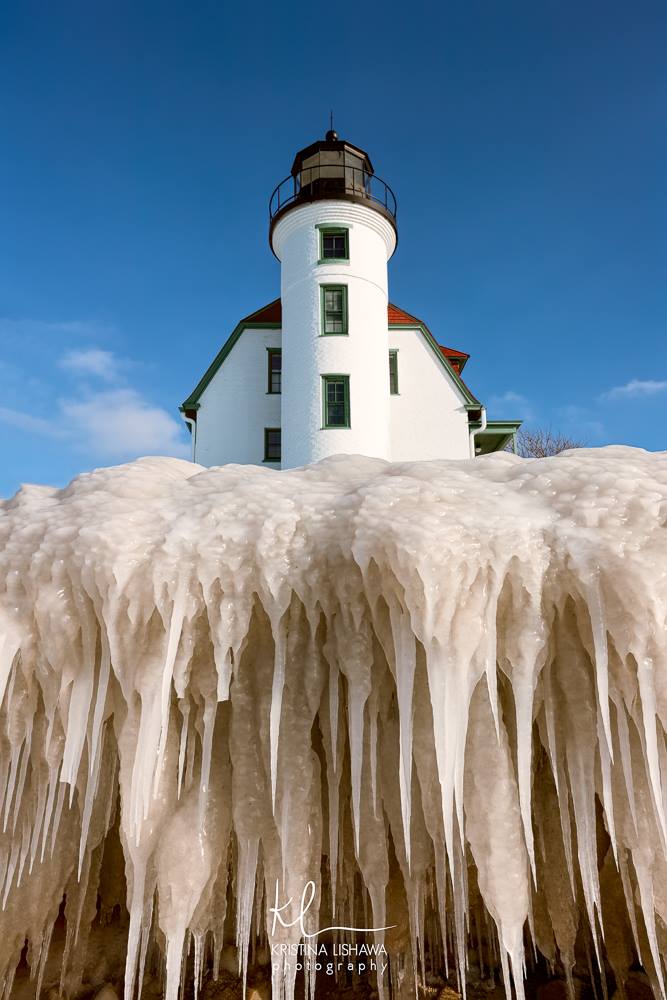
Methdown, photo by Andrew McFarlane

“2016 is remarkably the third record year in a row in this series We don’t expect record years every year, but the ongoing long-term warming trend is clear.”
– NASA Goddard Institute for Space Studies Director Gavin Schmidt

NASA reported last week that 2016 was the warmest year on record: You can read about it below, but I would like to offer two thoughts to the people who are getting angry about me ruining their daily photo with “politics”:

This is not politics. This is provable science backed up with excellent data.

While NASA (and I) believe in anthropocentric climate change (climate change driven by human activity) disbelief in that model DOESN’T MEAN IT’S NOT HAPPENING.

Earth’s 2016 surface temperatures were the warmest since modern recordkeeping began in 1880, according to independent analyses by NASA and the National Oceanic and Atmospheric Administration (NOAA). Globally-averaged temperatures in 2016 were 1.78 degrees Fahrenheit (0.99 degrees Celsius) warmer than the mid-20th century mean. This makes 2016 the third year in a row to set a new record for global average surface temperatures.

The 2016 temperatures continue a long-term warming trend, according to analyses by scientists at NASA’s Goddard Institute for Space Studies (GISS) in New York. NOAA scientists concur with the finding that 2016 was the warmest year on record based on separate, independent analyses of the data.

Read on for more at NASA.

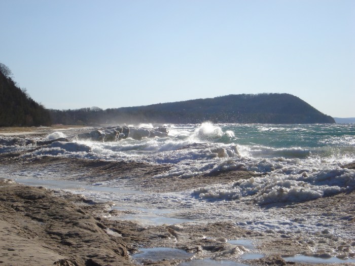
You can view my photo from a thaw in early February 2009 background big and see more in my Frozen Shore slideshow.

Cracking Ice

cracking-ice

Cracking Ice, photo by Jerry James Photography

Jerry writes: As I stood on the Ice waiting for the sun to set ( we was 1 1/2 hours early ) I could here all the ice around me cracking. talk about being paranoid, I wasn’t out to deep but it was still pretty cold and I wasn’t dressed to get wet. but everything ended good though, I stayed dry.

Always a good idea to be careful and know what’s below you when the temperatures rise.

View his photo from Muskegon bigger, see more in his slideshow, and follow Jerry James Photography on Facebook.

Ice is Nice: Tracking Ice Cover on the Great Lakes

shoreline-ice-on-lake-michigan

Shoreline Ice, photo by Mark Swanson

Ice on Michigan’s Great Lakes has become something of a phenomenon in the last few years, attracting photographers and thousands more to see the ephemeral beauty created by wind, water, and freezing temperatures. But ice has other important purposes, as NOAA’s Great Lakes Environmental Research Laboratory page on Great Lakes Ice Cover explains:

Ice formation on the Great Lakes is a clear signal of winter. Looking back in time, the lakes were formed over several thousands of years as mile-thick layers of glacial ice advanced and retreated, scouring and sculpting the basin. The shape and drainage patterns of the basin were in a constant state of flux resulting from the ebb and flow of glacial meltwater coupled with the rebound of the underlying land as the massive ice sheets retreated.

Heavy ice cover can reduce the amount of evaporation from the Great Lakes in the winter, thus contributing to higher water levels.

In bays and other nearshore areas, ice forms a stable platform for winter recreational activity such as ice fishing. This stable ice also protects wetlands and the shoreline from erosion.

  • 94.7% ice coverage in 1979 is the maximum on record (data began in 1973)
  • 9.5% ice coverage in 2002 is the lowest on record
  • 11.5% ice coverage in 1998, a strong El Niño year
  • The extreme ice cover in 2014 (92.5%) and 2015 (88.8%) were the first consecutive high ice cover years since the late 1970s.

NOAA pegs the current ice cover at 9.9% and you can also watch an animation of the last 60 days of ice formation. You can check out satellite images of the Great Lakes for current ice cover and also this cool animation of Great Lakes ice cover from 1973 – 2016.

Mark took this photo a little over a week ago at Lincoln Township Park near Stevensville. With the warmer weather, there’s probably less. View his photo bigger and see more in his Michigan Winter slideshow.

Turtle Club

turtle-club

Turtle Club, photo by Andrew McFarlane

“Am I not turtley enough for the turtle club?”
-Dana Carvey, Master of Disguise

Pretty sure it’s just sleeping.

I took this photo last weekend on a walk along Lake Michigan in the Leelanau Conservancy’s Whaleback Natural Area just south of Leland.

View it background big and see more in my Lake Michigan, Pearl of America slideshow.

More winter wallpaper on Michigan in Pictures.