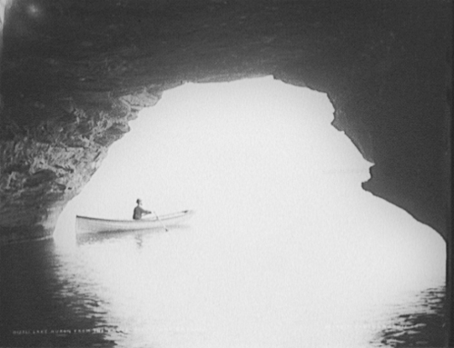
Lake Huron from the caves, Pointe aux Barques
The United States Library of Congress is a shining example of why we need government: to perform the vital work of preserving our heritage. One of the ways you can experience this preserved heritage is through American Memory from the Library of Congress. According to the mission, American Memory provides free and open access through the Internet to written and spoken words, sound recordings, still and moving images, prints, maps, and sheet music that document the American experience. It is a digital record of American history and creativity.
Today’s selection is from a gallery of photos from the collection of the Detroit Publishing Co. taken on and around Lake Huron near Pointe aux Barques and Port Austin in Huron County. It’s a gallery of 20 photos of natural wonders like Turnip Rock and structures such as the Port Austin Reef Light (if that link doesn’t work for you, try the Pointe Aux Barques link on this page).
You can get some great present-day photos of the shoreline at Port Austin Kayak Rental … either in their gallery or by renting a kayak and taking your own! If you have taken any photos of the area, please feel welcome to post links to them in the comments! Port Austin Kayaks also helpfully provided a map link that lets us give you this cool satellite view of the Port Austin shoreline! (I believe that point at the western edge is where Turnip Rock is)
Library of Congress LC-D4-12361
Updated Oct 2, 2008: Check out modern day photos in Kayaking Point Aux Barques!