
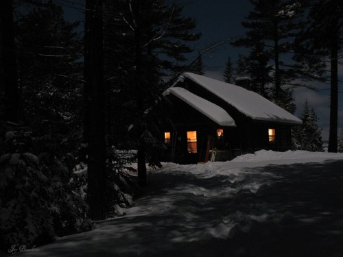
Fourteen Foot Shoals Cabin, photo by DIsnowshoe
DIsnowshoe has some beautiful photos of this cabin at Cheboygan State Park (slideshow).
The web site for Cheboygan State Park has more about the cabins and also their rustic teepees.
Fourteen Foot Shoals Cabin, photo by DIsnowshoe
DIsnowshoe has some beautiful photos of this cabin at Cheboygan State Park (slideshow).
The web site for Cheboygan State Park has more about the cabins and also their rustic teepees.

Mackinac Point Lighthouse at sunset, photo by the pentax hammer.
Gary asks that you please view this the way it should be viewed: Large On Black. See this photo (and many more) larger in his Junk on Explore slideshow.
On his Seeing the Light entry for Old Mackinac Point Lighthouse, Terry Pepper writes that as the connecting passage between Lake Michigan and Lake Huron, the Straits of Mackinac have always been critical to maritime commerce. As the Straits are frequently shrouded with fog, Mackinac Point was an ideal location for a fog signal building and lighthouse and an effort to build a facility began in 1888 and was completed with the installation of a red Fourth Order Fresnel lens in 1892:
As the use of automobiles became increasingly widespread in the early 1900’s, Midwesterners began to take increasing advantage of the newfound freedom that their automobiles provided, driving ever increasing distances to vacation. The unspoiled beauty of Michigan’s Upper Peninsula beckoned, and regular car ferry service began to ply the waters between Mackinaw and St. Ignace. With large amounts of vessel traffic now moving through and across the Straits, the Old Mackinac station became increasingly important as the light enabled the car ferries to operate throughout the night.
When the Mackinac Bridge opened in 1957, the car ferries were out of business, and with the brightly illuminated bridge serving as a navigation aid par excellence, the old light station was immediately rendered obsolete and was decommissioned.
The facility is now part of Mackinac Island State Historic Parks, and you can visit their Old Mackinac Point Lighthouse pages for history of the light and some great old photographs and educational resources for kids.

gull slide, photo by mfophotos
Frequent Michigan in Pictures contributor Mark O’Brien has just published A Polaroid Elegy – My Last Year With A Polaroid Camera. He writes:
This book is really about a journey into the slightly surreal world of Polaroid photography. Not everything you see looks the same after being shot with a Polaroid camera, and this book may give you a better appreciation for the wonderful invention of Edwin Land. The film used to create the photos in this book will no longer be available, hence the title.
Click through to preview and order the book. You can see many Polaroid photos Mark has taken in his Polaroids slideshow (photo set).
No Polaroids you say? Savepolaroid.com (where you can learn more about the history of Polaroid and Edwin Land’s work) notes that on February 8, 2008, Polaroid Corporation announced that it will discontinue production of all instant film. Apparently there is something called PolaPremium that will be revealed in a few days, so all may not be lost. Speculation is rampant.

Port Sanilac life preserver, photo by Deep blue ocean.
Be sure to check this baby out bigger (and this one too)!
Wikipedia says that Port Sanilac is a village in Sanilac Township of Sanilac County, pop 658:
This village was originally a lumberjack settlement on the shore of Lake Huron named “Bark Shanty Point.” In the late 1840s and 1850s, the settlement gained its first sawmill, schoolhouse, and general store. In 1854, Bark Shanty Point’s first post office opened. In 1857 the village was renamed to Port Sanilac, as it is in Sanilac Township in Sanilac County. Local legend attributes the name to a Wyandotte Indian Chief named Sanilac.
This photos is from the Port Sanilac Marina (marina web cam). More about the town at the village at Port Sanilac web site.

26 flowerpot, photo by northern_latitudes.
This photo is part of northern latitudes’ Point Aux Barques set of photos. You just gotta see the slideshow – some great shots of these cool rock formations and the Port Austin Reef lighthouse!
There’s some old photos of the Pointe Aux Barques area from the Library of Congress on Michigan in Pictures that you might enjoy too!

Waterspout from Oval Beach in Saugatuck, photo by Jim Thias
I’m not sure where exactly I should link to for Jim, so here’s his great pictures on railpictures.net.
The archived article on Waterspouts on Lake Michigan – where I found this photo – from NOAA’s National Weather Service Weather Forecast Office in Grand Rapids has a number of photos taken from Holland & Saugatuck on September 29, 2006. They explain that:
Waterspouts are somewhat common over the Great Lakes in the Fall season. Waterspouts in the fall occur when colder air above the surface moves over the still relatively warmer waters of Lake Michigan. Most waterspouts that occur in this type of scenario typically occur under plain showers and are much weaker than their summer counterparts. This fall type of waterspout is different from waterspouts associated with thunderstorms. They also form differently than waterspouts associated with thunderstorms.
The National Weather Service in Gaylord has a lot more about the science behind waterspout formation that includes a kicking photo of a group of spouts over Lake Huron in the fall of 1999. They say that boaters should take waterspouts seriously and seek immediate shelter when they are forecast. Waterspouts come in two types: tornadic and fair weather.
Tornadic waterspouts generally begin as true tornadoes over land in association with a thunderstorm, and then move out over the water. They can be large and are capable of considerable destruction. Fair weather waterspouts, on the other hand, form only over open water. They develop at the surface of the water and climb skyward in association with warm water temperatures and high humidity in the lowest several thousand feet of the atmosphere. They are usually small, relatively brief, and less dangerous. The fair weather variety of waterspout is much more common than the tornadic.
You can get a lot more great photos in a search for waterspout on the WOOD-TV blogs. I guess I can link over to this waterspout feature on Leelanau.com that includes my own photo of some waterspouts over the Manitou Islands.

at Mackinac :: a composite from -3 and -43 by Emery Co Photo
Last night I was looking for Creative Commons photos* with the appropriate license of the Mackinac Bridge so I could photoshop up a little something for Weird Wednesday: Michigan Sea Monsters (be sure to go back and read this!). I love it when the last Wednesday of the month rolls around as I get a chance to indulge my love of fooling with Photoshop. I was especially fired up as this month’s feature from Weird Michigan by Linda S. Godfrey because it was the feature that I had hoped to run last year as the debut of Weird Wednesdays on Absolute Michigan.
In my search, I saw this photo of the Bridge and thought “Now that looks cool & misty.” Then I came upon this photo of a rock and said “Sea serpent ahoy!” The coolest part was that both photos were taken by Emery Co Photo (emerycophoto.com). I contacted her and she graciously allowed me to use them.
Hope you all get some time on the water this weekend and that everyone remembers that on the list of things we should be worrying about, sea serpents in Michigan come in somewhere around #23,432,555. ;)
*That would be the Attribution-ShareAlike Creative Commons license. There are also a number of people in the Absolute Michigan pool who have told me that they are OK with me manipulating their photos for features on Absolute Michigan.
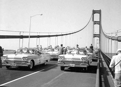
While this year’s annual Labor Day walk across the Mackinac Bridge isn’t getting nearly the fanfare of last year’s 50th anniversary walk across the Mighty Mac, it’s still the one day each year that you can walk across Michigan’s engineering wonder.
The photo above is from the Opening Ceremony gallery at the Mackinac Bridge Authority web site where you can also find a Bridge Walk gallery and more information about the bridge. For a ton more photos and stories about the Mackinac Bridge, click the button below!


Saginaw River Lighthouse, photo by SNiedzwiecki.
Stacy says that she took this photo on a boat tour of the Saginaw River and that access is very limited. It’s one of a number of photos in her Michigan Lighthouses set. She has also placed it on a map.
Terry Pepper’s page on the Saginaw River Rear Range Light brings the usual 110% of awesome with historical photos and a complete history of the lighthouse that explains (in part):
Eleventh District Engineer Major Godfrey Weitzel’s design for the combined rear range tower and dwelling was unique. Consisting of a large elevated concrete base supporting a combined brick dwelling and tower, the swampy ground in the chosen site first required the driving of timber piles deep into the ground to provide a solid foundation on which timber forms for the concrete base could be erected and filled. Atop this concrete foundation, a square two-story Cream City brick keeper’s dwelling 26′ 6″ in plan was constructed. Integrated into the northwest corner of the dwelling, a tapered 53′ tall square tower with double walls housed a set of prefabricated cast iron spiral stairs. Winding from the cellar to the lantern, these stairs also serving as the only means of access to the first and second floors by way of landings on each floor, each outfitted with tightly fitting arch-topped iron doors designed to stem the spread of fire between floors. A timber deck supported by timber columns encircled the dwelling at the first floor level, providing easy and dry access to all sides of the structure. The living quarters consisted of a kitchen, parlor and oil storage room on the first floor, and three bedrooms above. The tower was capped with a square iron gallery, supported by five cast iron corbels on each of its four sides. An octagonal cast iron lantern was installed at its center, with a fixed white Fourth Order Fresnel lens placed at a focal plane of 61 feet.
You can also check out some photos of the light and information from the Saginaw River Marine Historical Society and read a bit about the possible haunting of the Saginaw River Lighthouse.


Lunchtime is Laker Time!, photo by mdprovost and American Victory, photo by smiles7
Last Wednesday, mdprovost captured this photo of the American Victory under the Blue Water Bridges between Port Huron, Michigan and Pte. Edward, Ontario. On Friday, smiles7 photographed the vessel as she passed through Sault St. Marie on the annual Engineer’s Day. And then they both added them to the Absolute Michigan pool on Flickr – how cool is that??!!
No word as to whether or not Kevin Bacon was aboard.
