

Pancake Ice, photo by ChiliFrei64
I believe that Daniel took this photo in Lexington. Check it out background bigtacular and see more in his Water slideshow.
More ice on Michigan in Pictures.
Pancake Ice, photo by ChiliFrei64
I believe that Daniel took this photo in Lexington. Check it out background bigtacular and see more in his Water slideshow.
More ice on Michigan in Pictures.

Low water levels, West Arm Grand Traverse Bay, photo by michiganseagrant
On Michigan in Pictures I usually blog beautiful things, but today I’m featuring an ugly thing that we in Michigan should all be concerned about. Traverse City based Circle of Blue has an in-depth feature on the record-low level of Lake Michigan-Huron:
The latest numbers released by the U.S. Army Corps of Engineers on February 5 show that both lakes Michigan and Huron — which are two connected lakes — are experiencing their lowest point since records began in 1918. Water levels were an average of 175.57 meters (576.02 feet) for the month of January, approximately 2.5 centimeters (1 inch) lower than the previous record set in 1964.
“Not only have water levels on Michigan-Huron broken records the past two months, but they have been very near record lows for the last several months before then,” said John Allis, chief of the Great Lakes Hydraulics and Hydrology Office at the Corps, in a press release. “Lake Michigan-Huron’s water levels have also been below average for the past 14 years, which is the longest period of sustained below-average levels since 1918 for that lake.”
The low water levels, which the Corps attributes to: below-average snowfall during the winter of 2011-2012, last summer’s drought, and above-average evaporation during the summer and fall of 2012, have the potential to hurt the Great Lakes’ shipping industry.
…For the water levels on Lake Michigan-Huron to reach even near-average water levels again, the Corps said it will take many seasons with above average precipitation and below-average evaporation.
Read on at Circle of Blue for much more including the struggles that wildlife are having with the changing climate. You can also view the release from the Army Corps of Engineers and see historic Great Lakes levels back to 1918. From the Army Corps, I learned that at 1 1/2 ft below normal, ships are losing 8-10% of their carrying capacity.
Beyond harm to the multi-billion dollar shipping industry which feeds countless industrial endeavors, the low lake levels are making many of our recreational harbors inaccessible. These feed our multi-billion dollar sport fishing industry and this has prompted Gov. Snyder to endorse a $21 million emergency dredging plan, $11 million of which would come from Michigan’s general fund. With over a half a million jobs in Michigan alone tied to the health of the Great Lakes, getting a handle on the threats that impact them are likely to be at the center of our policy and spending for a long time.
In a curious bit of synchronicity, you can see just how vital the Great Lakes are to Michigan in Michigan Sea Grant’s reports on Economic Vitality and the Great Lakes. View this photo bigger and see more in their Grand Traverse Bay Low Water slideshow.
Lots more Lake Huron and Lake Michigan on Michigan in Pictures.
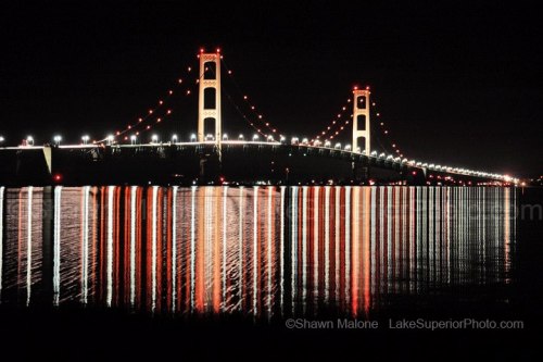
Mackinac Bridge at Night, photo by Shawn Malone
Shawn Malone (follow her at Lake Superior Photo on Facebook) explains that this shot of the Mackinac Bridge was a long exposure where the wind went from calm to a 15-20 mph gust during the exposure, producing that crazy texture on the water – almost like a double exposure.
See it bigger on Facebook, see more in her Mackinac Bridge slideshow and (if you like) purchase it online!
More of the Mackinac Bridge on Michigan in Pictures.

Winter 2011 – Lake Ice, photo by danbruell
The Great Lakes Echo reports that:
A composite map of the Great Lakes produced by NOAA’s CoastWatch organization shows near-historic low ice coverage across the region.
The map, known as the Great Lakes Surface Environmental Analysis, is a composite of data taken from NOAA satellites orbiting the earth’s poles and radar scans of the lakes by the National Ice Center. The resulting image shows surface water temperature and ice coverage, important data for region scientists, fishermen and boaters. The map’s data is updated daily.
“Previously, the lowest ice coverage year was 2002,” CoastWatch manager George Leshkevich said. “2012 came very close to 2002, and this year is looking very similar to last year.”
Lack of ice cover leads to increased water evaporation, a serious concern in light of already-low lake levels.
You can read more about last year’s ice cover and impacts on Absolute Michigan.
Check Dan’s photo out background bigtacular and see more in his Lake Ice slideshow.
More winter wallpaper on Michigan in Pictures!

Cheboygan Crib Light, photo by yooper1949
Terry Pepper’s Seeing the Light says that the plan for the Cheboygan Crib Light that was drawn-up by the District Engineer called for a round crib with an octagonal cast iron pierhead beacon centered upon it.
Work began with the construction of a wooden crib onshore in Cheboygan, which was then lowered into the water and towed out to the specified location at the entrance to the dredged river channel. Sunk in place with the addition of crushed rock, an upper level consisting of oak timber framework was then constructed atop the crib, with a basement oil storage room beneath the location in which the tower was to be installed. The deck of this superstructure was then leveled at a height of eleven feet above the water, planked with timber and fitted with a circular oak ring centered over the oil storage room to serve as an anchoring foundation for the cast iron tower itself.
…One can only imagine the drudgery involved for the keepers who manned this station. Every afternoon he would have to leave the safety of the dwelling in Cheboygan and row the 1/4 mile out to the light in whatever weather the lake was dishing-up that day. On arrival at the crib, he would carefully secure his boat at the foot of the crib, and then gingerly step from the heaving boat onto the eleven foot ladder, climbing up to the deck while simultaneously carrying any supplies needed for the night. The lamp would illuminated at dusk, and the keeper would then sit in the solitude of the tower, huddled close to the stove to keep warm on cold nights during the late season, making frequent climbs to the lantern to adjust the light by trimming the wick, winding the occulting mechanism and adding fuel to the lamp. As dawn finally raised its head across the Straits of Mackinac, the lamp would be extinguished, and the illuminating apparatus, lens and lantern would be cleaned in preparation for illumination later that day. The keeper would then row the ¼ mile back to shore to get some sleep, knowing that he would have to back out on the crib to repeat the cycle a few short hours later.
Sounds like a wonderful job. Read lots more about the light from Terry Pepper.
If I were looking for northern lights, I might follow Carl around. He shot this on November 30th. See it background bigtacular and see more in Carl’s Northern Lights slideshow.
Want more lighthouses or northern lights? We have both on Michigan in Pictures…

The U.S. Life Saving Station, early 1900s, photo courtesy Pointe Aux Barques Lighthouse Society
Glen Willis of the Pointe Aux Barques Lighthouse Society has an excellent article on The Great Storm of 1913 that explains that most historians agree that the most significant and most dreadful storm on Lake Huron took place over the weekend of November 8-10, 1913. Known by all mariners simply as “The Storm”, it was first detected on the western end of Lake Superior on Thursday, November 6th then progressed rapidly south and east, dropping temperatures and spawning marine warnings.
At Pointe aux Barques as the temperature dropped, it began to rain. As the wind picked up the rain turned to sleet. The sleet began to ice up everything it touched. The waves offshore quickly reached 10 to 12 feet, and then more. Then the snow came, thick and wind driven. Shipmasters out on the lake were finding sailing conditions that were unlike any they had seen before. The sleet that had coated their vessels turned the pilothouse windows opaque. It sealed and froze the doorways. To step outside a cabin meant that the skin would be painfully pelted by frozen bits of sleet & snow…
By midday Sunday at Pointe aux Barques, the snow was so thick and so heavily driven by the wind that vessels out on the lake could not see the rays of the light. At nearby Harbor Beach waves had already destroyed some lakefront buildings and had run the 552-foot D.O. Mills ashore. At mid-lake the wheelsman on the 500 foot Howard M. Hannah, Jr. found that the forward motion of the ship had ceased and that the bow had fallen off into the trough of the waves. Without enough power to drive it the ship was at the mercy of the elements. Waves were higher than the ship is tall and as they crashed down upon the ship the windows and the cabins were stove in. The ship was not under command and as it drifted into Saginaw Bay the master could see the flash of the Port Austin Reef Light. He then knew that his ship would not be saved.
Read on for much more and also check out several articles on the deadliest storm in Great Lakes history on Michigan in Pictures and Freshwater Fury on Absolute Michigan.
Pointe aux Barques is the oldest continuously operating Light on the Great Lakes, and the Pointe Aux Barques Lighthouse Society preserves the light and operates a museum. Visit them for more!
More shipwrecks on Michigan in Pictures.

be always an explorer, photo by .brianday
A good motto for the weekend … or a lifetime.
Check this out on black and see this and many more shots in Brian’s long exposure slideshow.
More black & white photography (including several by Brian) on Michigan in Pictures.

RockPort I, photo by Jeff Gaydash
In the course of writing about on how Alpena was named, I ran across this great photo from Rockport. It used to be called the Rockport Property, and in February it became the newest state park in Michigan. The DNR news release explains:
Rockport State Park offers many unique and special features. With 4,237 acres of land located on the shores of Lake Huron, north of Alpena, the property includes a deep-water protected harbor, an old limestone quarry of approximately 300 acres, a unique series of sinkholes, a dedicated Natural Area (Besser Natural Area), and a broad range of land types, vegetative cover, cultural resources and recreation opportunities. At the harbor, the Department has a boat launch facility, and there is a small park developed by Alpena Township on land leased from the State.
There’s no map on the DNR Park website yet, but you can get directions and some more photos from Quiet Solo Pursuits.
Check this out on black and in Jeff’s fantastic The Great Lakes slideshow.
Happy weekend everyone…

Old Off Shore Alabaster Loading facility, photo by hz536n/George Thomas
One of the neatest features for me about Michigan in Pictures are the many things I learn from the photos that are posted. Today’s photo of the Lake Huron loading platform for US Gypsum is a perfect example. The Iosco County Historical Society explains that:
The tramway of the U. S. Gypsum Company at Alabaster has long been a tourist attraction. Built in 1928 the tramway stretches 1.3 miles out into Saginaw Bay. Like a horizontal ski-lift, the cable system carries 72 “buckets” of gypsum to a waiting ship or to the storage bin. Each bucket holds more than two tons. The tramway includes 6,450 feet of one and three-quarter inch steel cable and 14,000 feet of three-quarter inch cable. At a length of 6,350 feet it is the longest over-water bucket tramway in the world.
…Until 1898 when the railroad spur was installed, all shipments were made by sailing vessels that tied up to a 600 foot dock. Marine shipments were resumed in 1929 after the building of the tramway enabled the larger ships to load in deeper water at the end of the tramway. Rail shipments were then made when the boat season was closed.
The tramway was dismantled (though concrete pads which may house wind turbines remain). You can also read an interesting account detailing the history of the town of Alabaster. While I knew that gypsum was used in drywall, I had no idea of its versatility (or Michigan’s status as a leading gypsum producer). You can learn about in great detail from MSU Geology’s page on gypsum:
If you were given a chance to win a jackpot by correctly naming a material that was used in the pyramids and in your toothpaste; that helps peanuts grow and makes movie snow; and that is used in mushroom beds and the walls of your house, chances are at least 100 to 1 that the quizmaster would holler “Sorry, your time is up,” before you could say “hydrous calcium sulphate.”
But, don’t feel badly.
Even though more than 12 1/2 million tons of gypsum were used in the USA last year, and even though the average person is surrounded by gypsum products from dawn to dusk, from the cradle to the grave, people do not know much about gypsum.
Gypsum can be ground up and “boiled” (calcined) at a comparatively low temperature until 75% of its moisture content has evaporated. When that happens, the rock becomes a fine powder, commonly known as Plaster of Paris. By returning the water to the powder, one can make a pliable mortar that can be formed into any shape and hardened. Gypsum is the only natural substance that can be restored to its original rock-like state by the addition of water alone.
Check this photo out background big and see more in George’s Fall 2009 slideshow.

Tug John Selvick in Bay Ship Canal, photo by boatnerd06
The Great Lakes Echo tipped me off to the new History Channel series Great Lakes Warriors. The show follows five captains battling winter storms on the Great Lakes as they break up ice, tow barges into port and try to stay alive. The second episode airs at 10:00 PM on Thursday, and the History Channel will rebroadcast the first episode, “The Lethal Season,” at 11:00 PM tonight. You can also watch it online at the History Channel.
That episode features the tug above – The John M. Selvick captained by John Selvick. Check it out background big and in Nathan’s massive Family Collections slideshow.
More boats on Michigan in Pictures.
