Great Lakes Waves offer beauty, power & danger

DSC01071P

Untitled, photo by Scott Glenn

“These are not lakes, these are the world’s eighth seas, and her bottom is littered with the wreckage of over six thousand ships.”
~The Three Sisters, Song of the Lakes

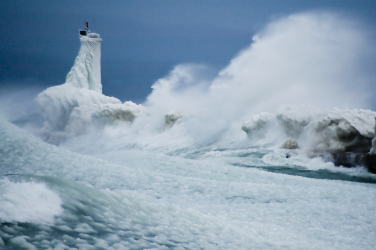
This gorgeous shot of the St. Joseph Pier Lighthouses demonstrates the incredible power of Great Lakes waves. I live in Traverse City, and this summer it feels like Lake Michigan has claimed the lives of more people than normal. Whether or not that’s true (it’s not), I thought this photo offered the perfect opportunity to share some tips and tools for staying safe on Lake Michigan, Lake Huron, Lake Superior and Lake Erie!

  • Thinking of any of the Great Lakes as anything like any lake you’re familiar with is a mistake. They are freshwater seas that can pack  incredible power. They are stronger than you and can end your life in an instant if you don’t respect them.
  • The Great Lakes Surf Rescue Project is a nonprofit dedicated to drowning prevention that keeps track of drowning statistics: 74 in 2010, 87 in 2011, 101 in 2012 and 39 so far in 2013. (you can also keep up with them on Facebook)
  • Life jackets can save your life.  U.S. Coast Guard statistics show that 90% of the people who drown in a boating or water accidents would survive with a life jacket.
  • Cold kills! Hypothermia is a danger all year round on the Great Lakes. Click that link for tips on how to stay alive if you do end up in the water.
  • Rip Currents (sometimes called “undertow” or “rip tide”) are a big danger on Michigan beaches accounting for the majority of drownings. Michigan is 4th in rip current related fatalities behind Florida, California, and North Carolina – we have “ocean force” rip currents. Learn how to beat them in this video.
  • The National Oceanic and Atmospheric Administration (NOAA) offers comprehensive Great Lakes marine forecasts.
  • The MyBeachCast smarthphone app can predict waves and warn you of hazardous conditions.
  • Do you have more tips? Share them in the comments!

Check it out bigger and see more in Scott’s Lighthouses slideshow and also check out a winter view of the pier that Scott shot.

Catch a Michigan wave on Michigan in Pictures!

Algae Blooms threaten Lake Erie

like an oil slick

like an oil slick, photo by 1ManWithACamera

I’d like to offer an apology of sorts for this photo. It goes like this: “I’m really, really sorry that I sometimes have to blog photos of the ugly things that threaten what’s beautiful in Michigan. I wish I didn’t have such a good reason to!”

Michigan has only the tiniest sliver of Lake Erie shoreline, so little that we sometimes forget that it is one of the lakes that define our Great Lakes State. Lake Erie served once at the canary in the coal mine for pollution of the Great Lakes, and it may once again be sounding a warning call. A recent front page of the New York Times featured scary news about algae blooms on Lake Erie:

For those who live and play on the shores of Lake Erie, the spring rains that will begin falling here soon are less a blessing than a portent. They could threaten the very future of the lake itself.

Lake Erie is sick. A thick and growing coat of toxic algae appears each summer, so vast that in 2011 it covered a sixth of its waters, contributing to an expanding dead zone on its bottom, reducing fish populations, fouling beaches and crippling a tourism industry that generates more than $10 billion in revenue annually.

…Dead algae sink to the lake bed, where bacteria that decompose the algae consume most of the oxygen. In central Lake Erie, a dead zone now covers up to a third of the entire lake bottom in bad years.

“The fact that it’s bigger and longer in duration is a bad thing,” said Peter Richards, a senior research scientist at the National Center for Water Quality Research at Heidelberg University in Ohio. “Fish that like to live in cold bottom waters have to move up in the thermocline, where it’s too warm for them. They get eaten, and that tends to decrease the growth rates of a lot of the fish.”

Read on for a whole lot more including how farming practices are intersecting with invasive zebra mussels and climate change to magnify the dangers.

Larry’s photo is from Lake Huron and shows a different kind of algal bloom. I got some similar ones on Lake Michigan, and the folks at Michigan Sea Grant have a whole album of them.

See it on black, view happier shots in his Caseville & Port Austin slideshow and see more of Larry’s work on Michigan in Pictures.

More Lake Erie on Michigan in Pictures.

Great Lakes Ice at near-record lows

Winter 2011 - Lake Ice

Winter 2011 – Lake Ice, photo by danbruell

The Great Lakes Echo reports that:

composite map of the Great Lakes produced by NOAA’s CoastWatch organization shows near-historic low ice coverage across the region.

The map, known as the Great Lakes Surface Environmental Analysis, is a composite of data taken from NOAA satellites orbiting the earth’s poles and radar scans of the lakes by the National Ice Center. The resulting image shows surface water temperature and ice coverage, important data for region scientists, fishermen and boaters. The map’s data is updated daily.

“Previously, the lowest ice coverage year was 2002,” CoastWatch manager George Leshkevich said. “2012 came very close to 2002, and this year is looking very similar to last year.”

Lack of ice cover leads to increased water evaporation, a serious concern in light of already-low lake levels.

You can read more about last year’s ice cover and impacts on Absolute Michigan.

Check Dan’s photo out background bigtacular and see more in his Lake Ice slideshow.

More winter wallpaper on Michigan in Pictures!

Great Lakes Warriors follows tug boat captains in winter

Tug John Selvick in Bay Ship Canal

Tug John Selvick in Bay Ship Canal, photo by boatnerd06

The Great Lakes Echo tipped me off to the new History Channel series Great Lakes Warriors. The show follows five captains battling winter storms on the Great Lakes as they break up ice, tow barges into port and try to stay alive. The second episode airs at 10:00 PM on Thursday, and the History Channel will rebroadcast the first episode, “The Lethal Season,” at 11:00 PM tonight. You can also watch it online at the History Channel.

That episode features the tug above – The John M. Selvick captained by John Selvick. Check it out background big and in Nathan’s massive Family Collections slideshow.

More boats on Michigan in Pictures.

Real-time Great Lakes Surface Currents

Get Up - Stand Up

Get Up – Stand Up, photo by Rudy Malmquist

The Great Lakes Echo highlighted a really cool realtime map of Great Lakes surface currents that can really help keep you safe whether you’re swimming, boating, surfing or stand-up paddleboarding. It might even help you find a fish or two!

Check this out background bigtacular and in Rudy’s water slideshow.

Battered but not Beaten: Great Lakes Week 2011

Battered

Battered, photo by James Marvin Phelps.

Invasive species, pollution, diversion – the threats facing the Great Lakes are legion.

This week (October 11-14) is Great Lakes Week, a partnership to improve the places around the Great Lakes basin basin where people live, work, learn and play. This week’s activities, meetings and conferences bring representatives of the U.S. and Canadian governments together in Detroit along with a broad coalition of public and private groups to highlight efforts to implement solutions for the lakes’ most pressing problems. It’s one of the most wide-ranging Great Lakes summits in history and you can watch it LIVE today starting at noon through Friday on Absolute Michigan or at greatlakesnow.org.

Check this photo of the Grand Haven Pier Light out background big and in James’ Michigan Lighthouses slideshow.

Earth Day, high above our piece of the Earth

Great Lakes, No Clouds

Great Lakes, No Clouds, photo by NASA Goddard Photo and Video.

Today is Earth Day (and also Good Friday). You can read all about Michigan’s role in Earth Day on Michigan in Pictures and check the list of Earth Day events in Michigan from earthday.org.

I thought this shot from the NASA Goddard Space Flight Center was a perfect image, and it’s a great lead-in to their Earth Day 2011 slideshow, which looks at almost 40 years of Landsat images. NASA says:

Launched in 1972, the Landsat program is the longest continuous global record of the Earth’s surface. It continues to deliver both visually stunning and scientifically valuable images of our changing planet, allowing us to plan for the future of Earth’s precious resources.

Check this out big as Michigan an in their Explored! slideshow.

Holga: Lake Erie

Holga: Lake Erie

Holga: Lake Erie, photo by Matt Callow.

Matt took this shot of an ice-locked Lake Erie 4 years ago. A check of Great Lakes Coastwatch shows that there’s still considerable ice on Lake Erie!

You can see it bigger in his Holga slideshow.

Many more Holga camera shots – including another one from this location by Matt – on Michigan in Pictures!

That’s a job creation engine out there…

Layers of Michigan Winter

Layers of Michigan Winter, photo by nasunto.

The Wall Street Journal reports:

An analysis by Michigan Sea Grant at the University of Michigan says more than 1.5 million U.S. jobs and $62 billion in annual wages are linked directly to the Great Lakes.

The study was released Thursday. It says Michigan has 525,886 jobs connected to the Great Lakes, more than any other state. Illinois ranks second with 380,786, followed by Ohio with 178,621.

Most of the jobs are in manufacturing. Others are in tourism and recreation, shipping, agriculture and other sectors of the economy.

Jim Diana, director of Michigan Sea Grant, says the study illustrates that protecting the lakes is crucial to attracting and retaining businesses and jobs.

That’s a lot of jobs … and at an estimated $62 billion in wages, it’s a very compelling argument for Michigan to take a leadership role in protecting the Great Lakes. Here’s the news release from Sea Grant and the PDF of the Great Lakes Jobs Report.

About the photo Nina writes On the shore of Lake Michigan: Cold sand and a layer of ice. In the distance, snow, ice, whitecaps on the beautiful and temperamental lake, and a cloud-filled sky. Check it out background big and in her Lake Michigan slideshow.

Fury: The White Hurricane of 1913

Furious Lake Michigan

Furious Lake Michigan Petoskey, photo by Odalaigh.

“No lake master can recall in all his experience a storm of such unprecedented violence with such rapid changes in the direction of the wind and its gusts of such fearful speed! Storms ordinarily of that velocity do not last over four or five hours, but this storm raged for sixteen hours continuously at an average velocity of sixty miles per hour, with frequent spurts of seventy and over.

Obviously, with a wind of such long duration, the seas that were made were such that the lakes are not ordinarily acquainted with. The testimony of masters is that the waves were at least 35 feet high and followed each other in quick succession, three waves ordinarily coming one right after the other.

~Report from the Lake Carriers Association in the wake of the Great Lakes “White Hurricane”

97 years ago the Great Lakes region reeled under the deadliest storm in its history. Known as the “Big Blow” and the “Freshwater Fury”, was a blizzard with hurricane-force winds that devastated the Great Lakes Basin in the Midwestern United States and the Canadian province of Ontario from November 7 through November 10, 1913. Read on for more!

Check this out bigger and in Charles’ Petoskey Storm Photos slideshow. He also has video of this storm.

Freshwater Fury: The Great Storm of 1913

Dear wife and Children. We were left up here in Lake Michigan by McKinnon, captain James H. Martin tug, at anchor. He went away and never said goodbye or anything to us. Lost one man yesterday. We have been out in storm forty hours. Goodbye dear ones, I might see you in Heaven. Pray for me. / Chris K. / P.S. I felt so bad I had another man write for me. Goodbye forever.

~A message found in a bottle 11 days after Plymouth disappeared, dictated by Chris Keenan, federal marshal in charge of the barge.

Wikipedia says that the Great Lakes Storm of 1913, also known as the “Freshwater Fury“or the “White Hurricane”, was a blizzard with hurricane-force winds that ravaged the Great Lakes November 7-10, 1913. With the sinking of 19 ships, the stranding of another 19 and a death toll of at least 250, it remains the deadliest and most destructive natural disaster in Great Lakes history.

Major shipwrecks occurred on all but Lake Ontario, with most happening on southern and western Lake Huron. Lake masters recounted that waves reached at least 35 feet (11 m) in height. Being shorter in length than waves ordinarily formed by gales, they occurred in rapid succession, with three waves frequently striking in succession. Masters also stated that the wind often blew in directions opposite to the waves below. This was the result of the storm’s cyclonic motion*, a phenomenon rarely seen on the Great Lakes.

In the late afternoon of November 10, an unknown vessel was spotted floating upside-down in about 60 feet (18 m) of water on the eastern coast of Michigan, within sight of Huronia Beach and the mouth of the St. Clair River. Determining the identity of this “mystery ship” became of regional interest, resulting in daily front-page newspaper articles. The ship eventually sank, and it was not until early Saturday morning, November 15, that it was finally identified as the Charles S. Price. The front page of that day’s Port Huron Times-Herald extra edition read, “BOAT IS PRICE” DIVER IS BAKER “SECRET KNOWN”. Milton Smith, the assistant engineer who decided at the last moment not to join his crew on premonition of disaster, aided in identifying any bodies that were found.

More shipwrecks on Michigan in Pictures!

Support Michigan in Pictures with Patreon