The Mackinac Bridge: Making Michigan, Michigan

Mackinac Bridge by rdmegr

Mackinac Bridge by rdmegr

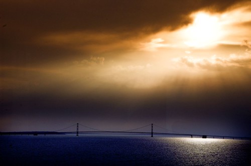
The photo by rdmegr was taken from high above the Straits of Mackinac, the name for the narrow passage between the Lower and Upper Peninsulas of Michigan. Lake Michigan is on the left and Lake Huron, the right with Mackinaw City (with a “w”) and the Lower Peninsula in the foreground and St. Ignace and the UP in the distance. It’s part of his Daytrip to Mackinac set of photos. Another photo from his flight to Mackinac of a freighter, the North Manitou Shoal Light and South Manitou Island was also blogged to Michigan in Pictures for general coolness and the fact that I heard his plane fly over my house.

I also have a confession to make: For months, I have been scared of the Mackinac Bridge.

This is distinct from the uneasiness that my mild phobia of falling off the Mackinac Bridge gives me when I drive over it.

Michigan’s Mackinac Bridge - 1957 - 2007
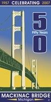
I have been scared because 2007 is the 50th Anniversary of the Mackinac Bridge. To me, other than the lake-etched outline of our state, there is no greater symbol of Michigan than the Mighty Mac.

5 miles long, 552 feet tall in nearly 300 feet of water, the Mackinac Bridge has seen over 120 million crossings required 3 years, over 11,000 people and 4 million tons of concrete and steel to build. (more facts)

And that’s only the barest glimmer of the story that needs to be told. From its conception in the 1800s, through the difficult construction, all the way up to the people who cross it for business or pleasure every day with hardly a pause, the Bridge is an essential part of what joins Michigan’s two peninsulas as one state.

If you have some links to share, please add them in the comments. We’ll be telling the story of the Mackinac Bridge piece by piece here and on Absolute Michigan, and we’ll post links to all the photos, stories and videos on The Mackinac Bridge page at Absolute Michigan. (look for the button!)

The Mackinac Bridge

Quite a view from the top of a Michigan – not California – Vineyard

Quite a view from the top of a Michigan--not California--Vineyard

Quite a view from the top of a Michigan–not California–Vineyard, photo by k2tibaldi.

April is Michigan Wine Month, a great time to Celebrate Michigan wine & wineries.

Wineries like this one on the Old Mission Peninsula* are every bit as lovely as those in other great wine regions and Michigan’s vineyards are producing award-winning wines that are the equal of any in the world.

*I am guessing Old Mission. Looks like Power Island in Grand Traverse Bay.

De Zwaan – Windmill Island

IMG_4887

De Zwaan, photo by norjam8.

This photo is one of a nice set of Holland, Michigan photos by Norm Hoekstra (makes a nice desktop background too!)

Wikipedia’s entry for Windmill Island says that the the 245-year-old windmill De Zwaan, Dutch for “the swan” or “graceful bird”, is the only authentic, working Dutch windmill in the United States:

In 1964, the City of Holland purchased the windmill De Zwaan from a retired miller in the town of Vinkel in the province of Noord Brabant, the Netherlands. The windmill was shipped from the Netherlands to the port of Muskegon, Michigan on the ship Prins Willem van Oranje. It was brought by truck from Muskegon to its present location on Windmill Island. Reconstruction of the mill began in 1964 and the park opened in April of 1965. The island, formerly farmed by Henry F. Koop, was chosen because of the favorable wind conditions there. Although originally a peninsula, a manmade canal turned the land into an assisted island. Before the arrival of De Zwaan, it was known as Hyma Island.

The Windmill has an article that goes more in-depth on this structure’s history. Flickr offers some pictures of windmills in Zandaam (where this one hails from). More info can be found in the City of Holland’s Windmill Island pages.

Mackinaw Bridge … Mackinac or Mackinaw?

Mackinaw Bridge

Mackinaw Bridge, photo by wyoming_1.

David Vernon writes:

An interesting picture. Taken from the somewhat world famous Cupola Bar at the Grand Hotel on Mackinac Island, looking west towards the wonderful Mackinaw Bridge. The sun was behind the clouds and setting fast but not entirely influencing life at the bridge colorwise.This shot was taken through a window but you have to look hard to see any reflection.

He can probably be excused for getting the last letter of the bridge wrong (though he is out of the spelling bee!) as he lives near the Mackinaw River in Illinois. Besides, it’s  confusing to know whether it’s Mackinac or Mackinaw. Regarding “Mackinac or Mackinaw?”, the St. Ignace Chamber says:

The native people called the area Michinni-makinong. The name was shortened over the years by French and British settlers. In the 1600s, the French pronounced the ending as “aw”, which translated to their spelling as “ac”. Michilimackinac, Fort Mackinac, Mackinac Island the Straits of Mackinac and the Mackinac Bridge are spelled with an “ac”, but pronounced “aw”. Upon the arrival of the British, a village established as Mackinaw was pronounced as “aw” and also spelled that way.

Basically, the bridge and the island are “ac” and the city is “aw”.

Jagged end on Belle Isle

Jagged end

Jagged end, photo by mainegal.

Is this photo of leaves like this photo of leaves? If it is, does that bother you?

This photo is from a new group on Flickr called Assignment: Detroit that assigns its members a location or theme to photograph and present their best pictures. The first assignment is Belle Isle. It sounds like a lot of fun and we’ll try and check back in at the end of the month!

Be sure and view this photo large because it’s amazing!

Mission Point Lighthouse, Lake Michigan

Mission Point Lighthouse,  Lake Michigan

Mission Point Lighthouse, Lake Michigan, photo by JSE_Imaging.

Speaking from experience, I have to say that the Old Mission light is one of the hardest to take a picture of. Probably all that fencing.

The lighthouse was established on March 3, 1859 and sits at the tip of Old Mission peninsula (the eastern peninsula that forms Grand Traverse Bay). Lighthouse guru Terry Pepper has a page on the Mission Point Lighthouse that includes an account of the taking of lands around the light from the Ottawa.

Wikipedia’s Mission Point Lighthouse entry is pretty limited, but it does have a link to an article that says the Old Mission light was a twin to the now destroyedMama Juda Lighthouse in the Detroit River (a/k/a Mamajuda).

South Manitou Island

South Manitou Island by rdmegr

South Manitou Island by rdmegr

When I logged on briefly last night to see what photos had been added during the day. Just about the first thing I saw was this amazing photo of South Manitou Island from the air. In addition to the freighter, the photo clearly shows the beautiful natural harbor that made South Manitou an early Great Lakes settlement and the North Manitou Shoal lighthouse (aka “the Crib”). As much as I love the maritime history of the Manitou Passage, the coolest thing for me is that I very clearly recall hearing the plane fly past just after 6 PM on Sunday evening.

The photo is part of Daytrip to Mackinac Island, a set of photos that also includes photos of the Island, Straits of Mackinac, the Mackinac Bridge and Sleeping Bear Dunes.