Happy 128th Birthday to the Grand Hotel

Grand Hotel at Night

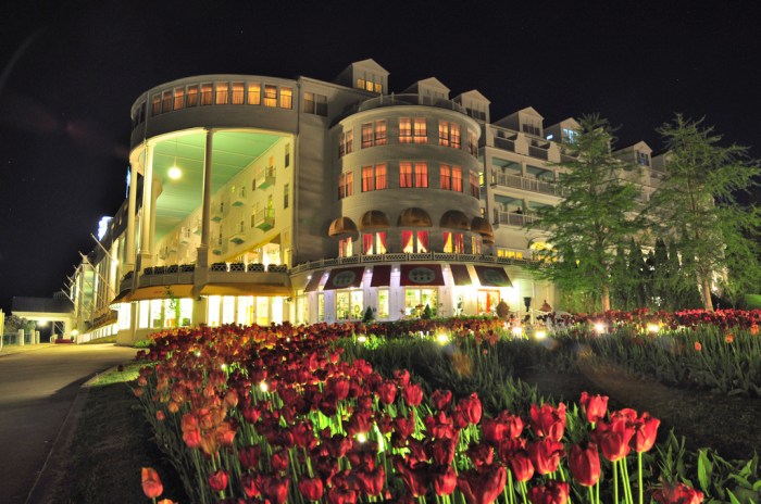
Grand Night, photo by Wade Bryant

Sending out an early Happy 128th Birthday to The Grand Hotel on Mackinac Island which opened on July 10, 1887. Here’s some historical highlights about Michigan’s most iconic hotel:

1887 Grand Hotel opens, billed as a summer retreat for vacationers who arrive by lake steamer from Chicago, Erie, Montreal, Detroit, and by rail from across the continent. Rates are $3 to $5 a night.

1890s Grand Hotel’s Front Porch – longest in the world—becomes the principal meeting place for all of Mackinac Island, as well as a promenade for the elderly and a “Flirtation Walk” for island romantics. Grand Hotel Manager James “The Comet” Hayes invites an agent of Edison Phonograph to conduct regular demonstrations of the new invention.

1895 Mark Twain lectures in the Grand Hotel Casino. Admission: $1.

1897 The West Wing is added to the hotel.

Turn of the century – The automobile finds its way onto the island. Grand Hotel supports an island-wide ban. A law is passed, but not strictly enforced until the 1930s.

1919 Hotel rates: $6 a day per person.

1935 A radio salon where patrons can listen to Jack Benny and other popular programs is added.

1947 This Time For Keeps starring Jimmy Durante and Esther Williams is filmed on the island and at Grand Hotel.

1960 Grand Hotel owner W. Stewart Woodfill appoints R.D. (Dan) Musser president of Grand Hotel.

1976 Musser and wife Amelia begin the redesign of the hotel’s interior and exterior with the help of architect Richard Bos and decorator Carleton Varney.

1979 The Mussers purchase Grand Hotel.

1980 Somewhere In Time, filmed at Grand Hotel and starring Christopher Reeve, Jane Seymour, and Christopher Plummer, is released.

1989 The U.S. Department of Interior designates Grand Hotel a National Historic Landmark.

View Wade’s photo from May of 2010 background bigtacular and see more in his My Favorites slideshow.

More Grand Hotel and more Mackinac Island on Michigan in Pictures!

Today in Spoiler Alerts: July 3, 1776

MEG_0653

Untitled, photo by Marvin Graves

I hope everyone has a great Independence Day weekend … though I suspect the Redcoats won’t.

View Marvin’s photo bigger and see more in his really great Fort Michilimackinac 2009 slideshow.

PS: If you ever get a chance to visit Colonial Michilimackinac in Mackinaw City, I heartily recommend it. Definitely one of Michigan’s coolest museums!

PPS: Love the Bridge peeking up just to the right of the flagpole.


Kitch-iti-Kipi: Michigan’s Largest Spring at Palms Book State Park

Big Spring (Kitch-iti-Kipi) Palms Book State Park

Big Spring (Kitch-iti-Kipi) Palms Book State Park, photo by Michigan Nut Photography

How about a big “way to go!” to the State of Michigan for a complete revamp their previously not very good Michigan Parks & Trails site? The new site is miles better!! The Palms Book State Park page says:

Palms Book is a rewarding side trip for the vacationer touring the Upper Peninsula, for here can be seen one of Michigan’s alluring natural attractions — Kitch-iti-kipi, The Big Spring. Two hundred feet across, the 40-foot deep Kitch-iti-kipi is Michigan’s largest freshwater spring. Over 10,000 gallons a minute gush from fissures in the underlying limestone. The flow continues throughout the year at a constant 45 degree Fahrenheit. By means of a self-operated observation raft, visitors are guided to vantage points overlooking fascinating underwater features and fantasies. Ancient tree trunks, lime-encrusted branches and fat trout appear suspended in nothingness as they slip through crystal waters far below. Clouds of sand kept in constant motion by gushing waters create ever-changing shapes and forms, a challenge to the imagination of young and old alike.

The legend of Kitch-iti-kipi is said to be about a young chieftain whose girlfriend got the best of him. He told her he loved her far above the other dark-haired maidens dancing near his birch bark wigwam. Prove it, she insisted. As a test of his devotion, she declared that he must set sail in his canoe on the pool deep in the conifer swamp. He was to catch her from his canoe as she leaped from an overhanging bough. His canoe overturned in the icy waters and he drowned. It turns out that the maiden was back at the village laughing at his foolish quest. According to legend, the Spring was named Kitch-itikipi in memory of the young chieftain who went to his death in the icy waters in an attempt to satisfy the vain caprice of his ladylove.

Other legends tell of Chippewa parents who came to the pool seeking names for their newborn. They supposedly found names like Satu (darling), Kakushika (big eye), Natukoro (lovely flower) and We-shi (little fish) scribed in the sounds of the rippling water. They attributed healing powers to the waters.

A drop of honey on a piece of birch bark dipped into Kitch-iti-kipi and presented to a loved one was to make them true forever. Another legend concerned the tamarack growing on the banks of Kitch-iti-kipi. A small piece of the bark ground in a mortar and pestle and placed in an individual’s empty pockets would be replaced by glittering gold at exactly midnight. Whatever the legends, visitors to the spring loved them. Kitch-iti-kipi is said to have many meanings in the Chippewa language-The Great Water; The Blue Sky I See; The Roaring, Bubbling Spring. Others called it the Sound of Thunder and Drum Water, even though the quiet is eerie. Whatever its name and legend, Palms Book State Park continues to draw curious visitors.

Although it was a black hole all but hidden in a tangle of fallen trees, John I. Bellaire fell in love with the Big Spring in the early 1920s…

Read on for the story of how it came to be a state park along with maps, photos and park events.

View John’s photo background big, purchase this photo and definitely follow him at Michigan Nut Photography on Facebook.

More Michigan parks on Michigan in Pictures!

#TBT: Atop Miners Castle

Atop Miners Castle

Atop Miners Castle, photo by Roger Dinda

On April 13, 2006 one of the most recognizable rock formations in the Pictured Rocks National Lakeshore, Miners Castle collapsed. The Lakeshore explains:

On Thursday morning, April 13, 2006, the northeast turret of Miners Castle collapsed. One turret remains on Miners Castle, the best-known feature of Pictured Rocks National Lakeshore. The collapse was reported via cell phone by fisherman in the area, according to chief ranger Larry Hach. Most of the rock fell north and into Lake Superior, and there were no injuries. The lower overlook platform near Miners Castle appears to be unaffected.

While the rockfall at Miners Castle on April 13 was startling, such events are not rare along the Pictured Rocks escarpment. At least five major falls have occurred over the past dozen years: 1) two different portions of Grand Portal Point, 2) the eastern side of Indian Head just east of Grand Portal Point, 3) Miners Falls just below the (now modified) viewing platform, and 4) beneath the lip of Munising Falls (along the former trail that went behind the cascade).

All the rockfalls involved the same rock unit, the Miners Castle Member of the Munising Formation. Rock units are named for places where they were first technically described. The Miners Castle Member consists of crumbly cross-bedded sandstone that is poorly cemented by secondary quartz, according to U.S. Geological Survey Research Ecologist Walter Loope.

Rockfalls along the cliffs typically occur in the spring and fall due to freezing and thawing action of Mother Nature.

Joel says that this photo was taken Roger Dinda in 1961 or ’62 “…before Pictured Rocks was a National Lakeshore, before Miners Castle lost its second turret, before they put up the boardwalks and railings. In this photo I’m just as tense as I look. I am deathly afraid of heights and this was (still is) about the scariest place I’ve ever been.”

View his photo background big more in his Lake Superior slideshow.

There’s more Throwback Thursdays, more Miners Castle & more from the Pictured Rocks National Lakeshore on Michigan in Pictures!

Waterfall (and Wayback) Wednesday: Potawatami Falls & Michigan’s Potawatami Tribe

24 Potawatomi Falls

24 Potawatomi Falls, photo by David Hedquist

GoWaterfalling’s page on Potawatomi Falls shares:

A very scenic waterfall along an especially scenic part of the Black River. An added plus is the close proximity of the equally impressive Gorge Falls. These are two of the most impressive falls on the Black River and are also the two easiest to access.

Potawatomi Falls is just upstream of Gorge Falls and is reached from the same parking area. Potawatomi is the name of one of the native tribes. This waterfall is wheelchair accessible. Gorge Falls is just a short walk away.

In low water, the waterfall is segmented, with most of the water going to the right. In high water the river covers the entire rock separating the two segments with a sheet of white water.

Head over to GoWaterfalling for directions and more. In case you were wondering (as I was), here’s a bit of Potawatomi history from Lee Sultzman that explains (in part):

In 1600 the Potawatomi lived in the northern third of lower Michigan. Threatened by the Ontario tribes trading with the French (Neutrals, Tionontati, Ottawa, and Huron) during the late 1630s, the Potawatomi began leaving their homeland in 1641 and moved to the west side of Lake Michigan in northern Wisconsin. This was completed during the 1650s after the Iroquois defeated the French allies and swept into lower Michigan. By 1665 all of the Potawatomi were living on Wisconsin’s Door Peninsula just east of Green Bay. They remained there until 1687 when the French and Great Lakes Algonquin began driving the Iroquois back to New York. As the Iroquois retreated, the Potawatomi moved south along the west shore of Lake Michigan reaching the south end by 1695. At about the same time, one band settled near Jesuit mission on the St. Joseph River in southwest Michigan. Shortly after the French built Fort Ponchartrain at Detroit in 1701, groups of Potawatomi settled nearby. By 1716 most Potawatomi villages were located in an area between Milwaukee to Detroit. During the 1760s they expanded into northern Indiana and central Illinois.

Land cessions to the Americans began in 1807 and during the next 25 years drastically reduced their territory. Removal west of the Mississippi occurred between 1834 and 1842. The Potawatomi were removed in two groups: the Prairie and Forest Bands from northern Illinois and southern Wisconsin went to Council Bluffs in southwest Iowa; and the Potawatomi of the Woods (Michigan and Indian bands) were relocated to eastern Kansas near Osawatomie.

View David’s photo background bigtacular and see many more photos and some videos in his Potawatomi Falls slideshow.

PS: David is the author of Waterfalling in Wisconsin: The Complete Guide to Waterfalls in the Badger State. I’m seeing a bunch of photos of Michigan waterfalls, so (maybe) stay tuned!

Soo Locks, Sault Ste. Marie Michigan

Sunset at the Soo Locks

Sunset | Soo Locks, photo by Camaeleo

While I’ve shared numerous photos from the Soo Locks, I’ve never provided the history of one of Michigan’s defining marvels. The Sault Ste. Marie Convention & Visitors Bureau has a brief Soo Locks history:

In 1797, the Northwest Fur Company constructed a navigation lock 38 feet long on the Canadian side of the river for small boats. This lock remained in use until destroyed in the War of 1812. Freight and boats were again portaged around the rapids.

Congress passed an act in 1852 granting 750,000 acres of public land to the State of Michigan as compensation to the company that would build a lock permitting waterborne commerce between Lake Superior and the other Great Lakes. The Fairbanks Scale Company, which had extensive mining interests in the Upper Penninsula, undertook this challenging construction project in 1853.

In spite of adverse conditions, Fairbanks’ aggressive accountant, Charles T. Harvey, completed a system of two locks, in tandem, each 350 feet long, within the 2 year deadline set by the State of Michigan. On May 31, 1855, the locks were turned over to the state and designated as the State Lock.

The federal government took control of the property and the lock system in the 1870’s. Their stewardship continues today, administered by the U.S. Army Corps of Engineers. The Soo Locks are the busiest locks in the world, and include the largest lock in the Western Hemisphere, completed in 1968.

You can click through for some more information and pictures, but definitely head over to the Detroit Army Corps of Engineers Soo Locks History page for a timeline of all the locks that have been built. You can also get an animated demo of how the locks work and look in on the locks via the Soo Locks Webcams.

View Camaeleo’s photo bigger and see more in their Sault Ste. Marie slideshow.

#TBT: Apple Island in Orchard Lake

Apple Island

Apple Island Aerial, photo via MSU Michigan History Student Publication

I was fascinated with the Farmer’s Almanac weather history tool this morning, so I went looking for notable Michigan happenings on June 18th…

Wikipedia’s Apple Island entry says that this 35-acre island was formed during the region’s last ice age (10,000 to 12,000 years ago) and lies in the middle of Orchard Lake. The West Bloomfield Historical Society has a nice article on Apple Island that says (in part):

Apple Island’s first admirers were Stone-Age Indians, who may have discovered it as early as 2,000 years ago. They were probably drawn to the site for its unique combination of land- and water-based resources, and the fact that their personal security was also enhanced on an island. It is not known exactly which Native Americans frequented Apple Island over the centuries before white settlement, but each group left clues to its way of life, including those which were raising crops at the time of Carpenter’s 1817 survey. In fact, the entire West Bloomfield lakes area has yielded many beautiful hammerstones, chert spearheads and birdstones – finely polished pieces of slate resembling stylized birds – left by their Native American owners long ago.

The treaty of November 17, 1807, negotiated with the Odawa, Ojibwe, Wyandot, and Potawatomi, ceded a tract of land comprising roughly the southeast quarter of the lower peninsula of Michigan and a small section of Ohio to the United States government. In time this land was surveyed, subdivided and offered for sale. Early settlers in what would become West Bloomfield Township noted that Native Americans visited the island often. In their language they reportedly referred to the area as “apple place” – a name which evidently stuck.

Read on for much more including the possibility that Chief Okemos was born on the island, its first purchase on June 18, 1827 by James Galloway and its current status as the Marjorie Ward Strong Woodland Sanctuary. Definitely check out Michigan History at MSU’s West Bloomfield – Apple Island feature for more photos & info and some really cool hand-drawn maps from the early 1900s.

The source of the “apple place” name is from Dr. Samuel M. Leggett’s epic poem The Legend of Me-nah-sa-gor-ning first circulated in 1909.

More Throwback Thursdays on Michigan in Pictures!

Shipwreck Saturday: The Wreck of the Minnehaha

Taking on Water

Taking on Water, photo by Aaron Springer

“She was built in 1880 [by Linn & Craig in Gibralter, Michigan] and has been unfortunate from the start. Two years ago [in 1891] she was wrecked near Detour [at the north end of Lake Huron], and remained on the rocks all winter, being abandoned to the underwriters, who finally rescued the wreck and sold it.”
~ Buffalo Evening News Monday, October 16, 1893

Historic Arcadia Michigan tells the tale of The Wreck of the Minnehaha:

In October of 1893, the steam barge Henry J. Johnson was towing the Minnehaha from Chicago bound for Point Edward at the south end of Lake Huron with 58,000 bushels of corn. At 7:30 PM on October 13, the two ships found themselves off Point Betsie facing 90 mile per hour gale force winds. They tried to find shelter behind the Manitou Islands, but at dawn the next day, they were still south of Sleeping Bear Point fighting high winds and waves to stay out of shallow water.

Captain Benniteau of the Johnson decided to turn the ships south and head to Frankfort, the nearest refuge. However, somewhere near Frankfort high waves crashed over the Minnehaha’s deck, smashed two hatch covers, and began filling the hold with water. William Parker, captain of the Minnehaha, realizing his ship was in serious trouble, sent up distress signals, released the tow lines, and headed for the beach. There was nothing the crew of the Johnson could do but avoid the same shallow water.

The Minnehaha ran aground about a quarter of a mile offshore between Burnham and Arcadia. To avoid the waves sweeping the decks, all but one member of the crew, who drowned trying to swim to shore, climbed into the ship’s rigging. As the ship was breaking up, the captain called to the crew to grab whatever would float and go over the side anyway. But only the captain made it to shore safely. One crew member made it to a pier, but was too tired to hold onto a pole used to try to pull him to safety.

Read on for much more including photos of the Minnehaha.

Check out Aaron’s photo bigger where he also has a pic of the wreck in calm water and see many more of his great photos of Lake Michigan.

More Michigan shipwrecks on Michigan in Pictures!

Yesterday & Today on Mackinac Island

Mainstreet Mackinac Island 1930s

NE Mackinac Mackinaw Island MI 1930s, photo by Don … The UpNorth Memories Guy … Harrison

I think that it’s pretty clear that Mackinac Island, a living museum boasting an intact Colonial era fort along with many exhibition buildings, The Grand Hotel and other historic businesses and NO CARS, is Michigan’s coolest state park. Today (June 11, 2015), Pure Michigan will be presenting Mackinac Island to the world (well, the internet at least) in a whole new way. They explain:

As the first state in the United States to ever conduct a real-time virtual guided tour, Pure Michigan is offering you the opportunity to experience Mackinac Island – virtually! We’re partnering with Georama, a real-time vicarious travel platform, so you can virtually tour the island just by simply logging into michigan.org/live on Thursday, June 11 at 12 noon to 4 pm Eastern. Tom Daldin, host of PBS show Under the Radar, will serve as your travel guide and adventure lead in this digital exploration.

…Begin your journey by taking a ferry ride to Mackinac Island before getting an up-close and personal view of the island.

We’ll take you to downtown Mackinac, home to some of the most lovely shops and art galleries in the state, offering you a chance to peek inside as well as interact with people on the streets to get their thoughts on the island known as America’s fudge capital. We’ll also tour Douds Market, America’s oldest family-owned grocery store for 131 years so you can see some of the store’s specialty items and get a history lesson on the market.

From there we’ll visit Fort Mackinac and round out our journey with a trip to the gloriously-designed Grand Hotel. We’ll give you a new perspective of this landmark and invite you to join us as we sip tea on the Grand’s famous front porch all while surrounded by 2,500 gorgeous geraniums.

Click through for more and tune in!

View the photo background big and see more of Don’s Mackinac Island postcards & photos on Flickr. Be sure to follow him on Facebook as well!

Michigan Ghost Towns: Aral at Otter Creek

Esch Beach

Esch Beach, Otter Creek, photo by Sara Hunt/oni_one_

The Sleeping Bear Dunes National Lakeshore tells the rich tale of the ghost town Aral:

Aral was located on Lake Michigan where Otter Creek empties into the Lake just south of Esch Road, a few miles south of Empire, MI. Today this is one of the most popular swimming beaches in the Lakeshore, but in the 1880s, Aral was a booming lumber town!

When the United States acquired land, it first had to be surveyed before it was made available to individuals. In the summer of 1849, Orange Risdon was one of the surveyors assigned to the area around Grand Traverse Bay. In 1853 soon after he finished the survey, Risdon and his wife, Sally, bought 122 acres where Otter Creek emptied into Lake Michigan.

The US Civil War began in 1861, and to induce able-bodied men to join the Union forces, the US government offered $100 bounty to men who enlisted. By 1863 the bounty was increased to $300, and finally a draft was instituted. An interesting provision of the draft act allowed drafted men to avoid service by hiring a substitute or by paying $300. One of the men receiving draft notice was Robert F. Bancroft, who was married and 30 years old. He chose to take advantage of this provision by hiring a German immigrant to take his place as a soldier, but interestingly he followed his replacement to the battlefield. Instead of carrying a gun, he brought his camera and became one of the first battlefield photographers.

Following the war, the veterans returned home, and Robert Bancroft settled with his wife Julia and daughter Anna in Traverse City. He began buying land in Platte and Lake townships as investments and in late 1864, he bought the 122 acres from Orange and Sally Risdon of Saline, MI.

Bancroft cleared 20 acres and built a log cabin for his family to live in. Then he planted some black locust trees and an apple orchard around the cabin. Lumber speculators soon arrived looking for stands of white pine. Most of the forest in this area was hardwood, but there were some stands of white pine inland from Otter Lake. By the late 1870s Daniel Thomas bought a 5-acre parcel on Lake Michigan south of Otter Creek, but he decided to build a house across the road from the Bancroft’s. Lumber speculators were on their way north as the forests near Grand Haven and Muskegon were harvested.

…By 1883, the lumber business was booming and the town was growing. A post office was required. The community was known as Otter Creek – the “Krik” by locals. When they applied for a post office, their name was rejected because there was already an “Otter Creek” in Michigan. “Bancroft” was the next suggestion, but again the name had already been used. One of the workers suggested the name “Aral” because of the beautiful Aral Sea in Europe. Locals continued to call it Otter Creek though. Dr. Frank Thurber was named the first postmaster. Keep his name in mind, for he too would play a central role in the murder.

Murder you say? Indeed – read on for lots more…

View Sarah’s photo background bigilicious on Facebook and follow her for lots more at oni_one_ on Instagram.