Milky Way and Stars over Ludington Lighthouse

Milky Way and Stars over Ludington Lighthouse

Milky Way and Stars over Ludington Lighthouse, photo by Craig

Craig writes:

The beacon shines brightly from both the North Breakwater Lighthouse and the South Breakwater Light in Ludington Michigan at night. The Milky Way and other stars shine brightly on this Lake Michigan scene.

View his photo bigger and see more in his slideshow.

Many (many) more Michigan lighthouses and more night shots on Michigan in Pictures!

As American as … Soccer

Manchester United vs. Real Madrid

Manchester United vs. Real Madrid, photo by Chad Miles

The Independent reports that a US record 109,318 fans turned out at Michigan Stadium to watch a “friendly” pre-season match between Manchester United and Real Madrid on Saturday. Read more in their report on the match and also see this SB Nation article for more pics of the massive crowd.

View Chad’s photo background bigtacular and see more in his slideshow.

There’s one in every crowd

There's one in every crowd

There’s one in every crowd, photo by Bill Dolak

Here’s hoping that whatever you stand for, you stand proud & strong! Enjoy your weekend folks!!

Check out Bill’s photo background bigtacular and see more in his massive Michigan: Kalamazoo County slideshow.

In addition to desktop backgrounds for summer in Michigan, one thing that Michigan in Pictures stands for is sunflowers – lots more at that link!

Blueberries by the Bushel!

Michigan Capitol Farmers' Market - July 31, 2014

Michigan Capitol Farmers’ Market, photo by David Marvin

It’s a good time to be hungry in Michigan!

View David’s photo background bigalicious and see more in his slideshow.

More summer wallpaper and more blueberry goodness on Michigan in Pictures!

Spray Masters Closing Pyramid

Spraymasters Closing Pyramid

Spraymasters Closing Pyramid, photo by mark zacks

Although this photo of the Spray Masters isn’t a TBT (Throwback Thursday) it sure feels like one!

View Mark’s photo background bigtacular and see more in Mark’s slideshow.

Even more pics on the Dixie Lake Facebook!

More summer wallpaper on Michigan in Pictures!

Sunset for the Ambassador: New Bridge Plan Coming Today

This is Ambassador Bridge - connects the USA and Canada.( a view from Detroit side). Picture taken during the "blue hour" Please enjoy the view the way I did.

This is Ambassador Bridge…, photo by MaRia Popi Photography

Sunset, or at least twilight has arrived for the privately owned Ambassador Bridge. The AP is reporting that there’s now a deal for the long-discussed bridge between Detroit & Windsor:

Canadian Transport Minister Lisa Raitt and Michigan Gov. Rick Snyder have called a news conference Wednesday about the planned new $2 billion bridge linking Detroit and Windsor, Ontario.

Snyder’s office said Tuesday that Raitt and the governor “will make an announcement regarding the New International Trade Crossing” at 10:30 a.m. Wednesday at the Canadian Club Heritage Center in Windsor.

The governor’s and transport minister’s offices declined immediate comment Tuesday on the nature of the announcement.

Michigan and Canadian leaders have agreed to build the bridge over the Detroit River between Windsor and Detroit’s southwest side.

Officials say Canada would finance construction of the bridge, which would open in 2020.

Definitely view Maria’s photo background bigtacular for the full impact and see more in her Detroit slideshow.

Point of Origin, part 2

Point of Origin

Point of Origin, photo by Jamie MacDonald

From the annual Jackson Hot Air Jubilee earlier this month.

View Jamie’s photo bigger and see more in his awesome Jackson Hot Air Jubilee slideshow.

(here’s Point of Origin, part 1 in case you missed it)

Point of Origin

The Heart of Detroit

The Heart of Detroit, photo by Maia C

The Point of Origin is located in Campus Martius Park in downtown Detroit. The park’s website explains:

In 1788, Campus Martius served as a drill ground for militia training. Campus Martius means “military ground” and was named after the Campus Martius at Marietta, Ohio, a 180-foot stockade.

After the fire of 1805, Judge Woodward was appointed to oversee the plan to lay out the streets, squares and lots with the assistance of the best surveyors from Canada. They placed their instruments and astronomical devices on the summit of a huge stone. He viewed the planets and meteors in order to determine “true North”. Today we still call this point the “Point of Origin” which is located in center of Campus Martius at the junction of Woodward and Monroe. It is from this point that the City of Detroit’s Coordinate system was created.

FYI, this photo appeared on Rolling Past 5000 on Michigan in Pictures, but only in a bit part as one of the zeros!

View Maia’s photo bigger and see more in her Downtown Detroit slideshow.

Michigan Milky Way Time Lapse

Milky Way Time Lapse - Silos - 2014 - D7100-142

Milky Way Time Lapse – Silos – 2014, photo by Matthew Eddy

Cloudy skies are in the forecast this weekend, but you can still check the stars out!

View the photo background big and see more in Matthew’s Milky Way Time Lapse video on YouTube!

The Making of the Mackinac Bridge

Bridge_HDR2.jpg

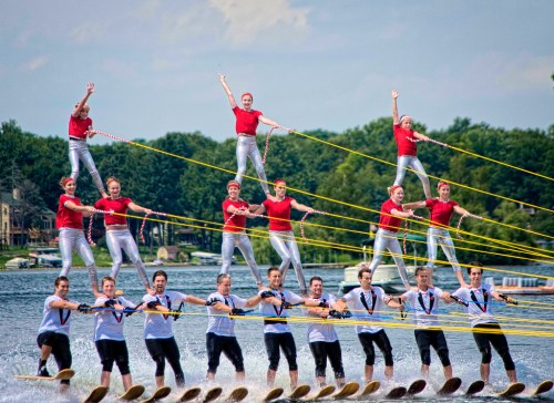
Bridge HDR 2, photo by Allison Hopersberger

A calm night on the Straits of Mackinac, and Michigan’s signature bridge was looking fine!

I’ve posted a ton about the Mighty Mackinac Bridge here on Michigan in Pictures, but had never seen this excellent summary of how it came to be courtesy the Michigan Dept. of Transportation’s page on I-75 and the Straits of Mackinac:

The five-mile stretch of water separating Michigan’s two peninsulas, the result of glacial action some twelve thousand years ago, has long served as a major barrier to the movement of people and goods. The three railroads that reached the Straits of Mackinac in the early 1880s, the Michigan Central and the Grand Rapids & Indiana Railway from the south, and the Detroit, Mackinac and Marquette from the north, jointly established the Mackinac Transportation Company in 1881 to operate a railroad car ferry service across the straits. The railroads and their shipping lines developed Mackinac Island into a major vacation destination in the 1880s.

Improved highways along the eastern shores of Michigan’s lower peninsula brought increased automobile traffic to the straits region starting in the 1910s. The state of Michigan initiated an automobile ferry service between St. Ignace and Mackinaw City in 1923 and eventually operated eight ferry boats. In peak travel periods, particularly during deer season, five mile backups and delays of four hours or longer became common at the state docks at Mackinaw City and St. Ignace.

With increased public pressure to break this bottleneck, the Michigan legislature established a Mackinac Straits Bridge Authority in 1934, with the power to issue bonds for bridge construction. The bridge authority supported a proposal first developed in 1921 by Charles Evan Fowler, the bridge engineer who had previously promoted a Detroit-Windsor bridge. Fowler’s plans called for an island-hopping route from the city of Cheboygan to Bois Blanc, Round, and Mackinac islands, thence to St. Ignace, along a twenty-four-mile route. The Public Works Administration flatly rejected a request for loans and grants to implement this project.

A plan was then drawn up for a direct crossing from Mackinaw City to St. Ignace, but they were again denied funds. In 1940, a plan was submitted for a suspension bridge with a main span of 4600 feet. This design was a larger version of the ill-fated Tacoma Narrows Bridge in Washington State, a structure destroyed by high winds on November 7, 1940. Although the disaster delayed any further action, the activities of 1938-1940 nevertheless produced some important results. The bridge authority conducted a series of soundings and borings across the straits and built a causeway extending out 4200 feet from the St. Ignace shore. The Second World War ended any additional work, and the Legislature abolished the bridge authority in 1947.

William Stewart Woodfill, president of the Grand Hotel on Mackinac Island, almost singlehandedly resuscitated the dream of a bridge across the Straits of Mackinac. Woodfill formed the statewide Mackinac Bridge Citizens Committee in 1949 to lobby for a new bridge authority, which the legislature created in 1950. A panel of three prominent engineers conducted a feasibility study and made recommendations to the bridge authority on the location, structure, and design of the bridge.

The State Highway Department, which had just placed a $4.5 million ferryboat, Vacationland, into service at the straits in January 1952, remained hostile to the bridge plan. In April 1952, the Michigan legislature authorized the bridge authority to issue bonds for the project, choose an engineer, and proceed with construction. The authority selected David B. Steinman as the chief engineer in January 1953 and tried unsuccessfully to sell the bridge bonds in April 1953, but by the end of the year, the authority had sold the $99.8 million in revenue bonds needed to begin construction.

View Allison’s photo bigger and see LOTS more in her Mackinac Island slideshow!