Storming the Harbors of Darkness: DH Day Barn Edition

Night and DH Day Barn

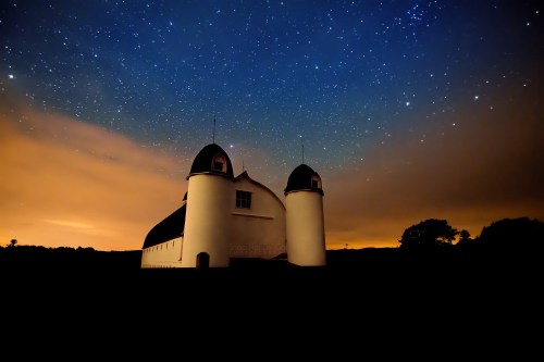
Night and DH Day Barn, photo by Heather Higham

This shot of the iconic D.H. Day barn in the Sleeping Bear Dunes National Lakeshore from a couple of days ago is beautiful, dramatic and … wrong. While the orange looks cool against the deep blue, it’s a very visible reminder that our night skies suffer from serious light pollution, even in our most preserved spaces. I encourage everyone to learn about night-sky friendly outdoor lighting options and to advocate in your community for better lighting decisions.

On a less preachy note, if you’re in the Traverse City/Sleeping Bear area tonight, the National Lakeshore is hosting the latest in their “Find Your Park After Dark” night sky events from 9-11 PM at the Pierce Stocking Scenic Drive #3 Overlook. They write:

All sky programs offered by the National Lakeshore are free. Participants need only purchase the Park Entrance Pass or have an Annual Pass displayed in their vehicle to join in the fun. Programs will be cancelled if the sky is not visible due to weather conditions. The decision to cancel is usually made three hours in advance. Please call 231-326-4700, ext. 5005, for a voicemail message with the decision. For all evening astronomy events, bring a flashlight for the walk back to your car and bug spray, if needed. Park rangers and Grand Traverse Astronomical Society (GTAS) staff will wear red glow bracelets at the events.

Each special event takes place at a different location throughout the National Lakeshore to take advantage of strategic viewing opportunities. You can come for star-gazing, eclipses, meteor showers, solar viewing, and storytelling. These events are the perfect opportunity to Find Your Park in the stars. Starry night skies and natural darkness are important components of the special places the National Park Service protects. National parks hold some of the last remaining harbors of darkness and provide an excellent opportunity to experience this endangered resource.

“Harbors of darkness” – what a cool turn of phrase! Head over to the National Lakeshore’s website for more about this and upcoming events.

Over at her blog, the Rapid City Recess, Heather writes about her experience shooting at night with two other photographers – I encourage you to read it.

View Heather’s photo bigger, see more in her Night Sky slideshow and definitely follow her at Snap Happy Gal on Facebook!

More night photography and more Michigan barns on Michigan in Pictures.

Soo Locks, Sault Ste. Marie Michigan

Sunset at the Soo Locks

Sunset | Soo Locks, photo by Camaeleo

While I’ve shared numerous photos from the Soo Locks, I’ve never provided the history of one of Michigan’s defining marvels. The Sault Ste. Marie Convention & Visitors Bureau has a brief Soo Locks history:

In 1797, the Northwest Fur Company constructed a navigation lock 38 feet long on the Canadian side of the river for small boats. This lock remained in use until destroyed in the War of 1812. Freight and boats were again portaged around the rapids.

Congress passed an act in 1852 granting 750,000 acres of public land to the State of Michigan as compensation to the company that would build a lock permitting waterborne commerce between Lake Superior and the other Great Lakes. The Fairbanks Scale Company, which had extensive mining interests in the Upper Penninsula, undertook this challenging construction project in 1853.

In spite of adverse conditions, Fairbanks’ aggressive accountant, Charles T. Harvey, completed a system of two locks, in tandem, each 350 feet long, within the 2 year deadline set by the State of Michigan. On May 31, 1855, the locks were turned over to the state and designated as the State Lock.

The federal government took control of the property and the lock system in the 1870’s. Their stewardship continues today, administered by the U.S. Army Corps of Engineers. The Soo Locks are the busiest locks in the world, and include the largest lock in the Western Hemisphere, completed in 1968.

You can click through for some more information and pictures, but definitely head over to the Detroit Army Corps of Engineers Soo Locks History page for a timeline of all the locks that have been built. You can also get an animated demo of how the locks work and look in on the locks via the Soo Locks Webcams.

View Camaeleo’s photo bigger and see more in their Sault Ste. Marie slideshow.

Know your Michigan Birds: Eastern Screech Owl

Eastern Screech Owl by Kevin Povenz

Eastern Screech Owl, photo by Kevin Povenz

The Owl Pages says (in part) that the Eastern Screech Owl (Megascops asio):

…is a small, nocturnal woodland Owl with short ear-tufts and yellow eyes. There is a greyish-brown, red and grey morph, with intermediates also occurring. The word “asio” is Latin for ‘Horned Owl’. Eastern Screech Owls have also been called the Common Screech Owl, Ghost Owl, Dusk Owl, Little-eared Owl, Spirit Owl, Little Dukelet, Texas Screech-Owl, Whickering Owl, Little Gray Owl, Mottled Owl, Red Owl, Mouse Owl, Cat Owl, Shivering Owl, and the Little Horned Owl.

…A nocturnal bird, with activity beginning after sunset. The Eastern Screech-Owl flies fairly rapidly with a steady wingbeat (about 5 strokes/second). They rarely glide or hover, but may fly with erratic movements, when manoeuvring through wooded areas. Their wings are broad and the head is held tucked in giving the bird a stubby appearance when flying.When threatened, an Eastern Screech Owl will stretch its body and tighten its feathers in order to look like a branch stub to avoid detection, but will take flight when it knows it has been detected. In open roosts, gray-phase birds tend to roost next to a tree trunk, whereas red-phase birds tend to roost in outer foliage, possibly because of thermal requirements.

…Eastern Screech Owls hunt from dusk to dawn, with most hunting being done during the first four hours of darkness. They hunt mainly from perches, occasionally hovering to catch prey. This Owl mainly hunts in open woodlands, along the edges of open fields or wetlands, or makes short forays into open fields. When prey is spotted, the Owl dives quickly and seizes it in its talons. They will also capture flying insects on the wing.

…Breeding season for Eastern Screech Owls is generally around mid April, but may range from mid March to mid May. They have an elaborate courtship ritual. Males approach females, calling from different branches until they are close. The male then bobs and swivels his head, bobs his entire body, and even slowly winks one eye at the female. If she ignores him, bobbing and swivelling motions intensify. If she accepts him, she moves close and they touch bills and preen each other.

… Eastern Screech Owls inhabit open mixed woodlands, deciduous forests, parklands, wooded suburban areas, riparian woods along streams and wetlands (especially in drier areas), mature orchards, and woodlands near marshes, meadows, and fields. They will avoid dense forests because Great Horned Owls use that habitat. They will also avoid high elevation forests. Eastern Screech Owls roost mainly in natural cavities in large trees, including cavities open to the sky during dry weather. In suburban and rural areas they may roost behind loose boards on buildings, boxcars, or water tanks. They will also roost in dense foliage of trees, usually on a branch next to the trunk, or in dense scrubby brush.

Read on for lots more about screech owls and definitely make owlpages.com your go-to for all things owlish (including screech owl gear).

View Kevin’s photo bigger on Flickr, see a lot more in his fantastic Birds of Prey slideshow and follow him at Kevin Povenz Photos on Facebook.

Requiem for a Spruce: Spruce Budworm in Michigan

April 11, photo by Michael Koole

April 11, photo by Michael Koole

Garret Ellison of the Grand Rapids Press & mLive writes that the Michigan Department of Natural Resources expects spruce budworm to inflict heavy damage on white spruce and balsam fir trees across the Upper and northern Lower Peninsulas this year:

The budworm is “one of the most destructive native insects” in the northern spruce and fir forests of the eastern U.S. and Canada. The worms drop as caterpillars from treetops on webs and feed on tree growth in the spring.

Repeated budworm defoliation can cause top-kill and death in older and stressed trees. Balsam fir older than 60 and spruce over 70 years are prime targets. Younger trees infested with budworms lose much new growth but generally survive.

Read on for more, including how to protect your trees. The U.S. Forest Service has more about the spruce budworm:

The spruce budworm Choristoneura fumiferana (Clemens) is one of the most destructive native insects in the northern spruce and fir forests of the Eastern United States and Canada. Periodic outbreaks of the spruce budworm are a part of the natural cycle of events associated with the maturing of balsam fir.

The first recorded outbreak of the spruce budworm in the United States occurred in Maine about 1807. Another outbreak followed in 1878. Since 1909 there have been waves of budworm out breaks throughout the Eastern United States and Canada. The States most often affected are Maine, New Hampshire, New York, Michigan, Minnesota, and Wisconsin. These outbreaks have resulted in the loss of millions of cords of spruce and fir.

Balsam fir is the species most severely damaged by the bud-worm in the Eastern United States. White, red, and black spruce are suitable host trees and some feeding may occur on tamarack, pine, and hemlock. Spruce mixed with balsam fir is more likely to suffer budworm damage than spruce in pure stands.

If you’re intrigued by the “natural cycle” as I was, head over to Wikipedia’s entry on Choristoneura fumiferana, the Eastern Spruce Budworm for an explanation and some pics of these (for a change) native pests.

View Michael’s photo bigger and see more (including lots of tasty macro) in his Around the Yard slideshow.

PS: Sorry about the Monday morning novel … sometimes I over share. ;)

Shipwreck Saturday: The Wreck of the Minnehaha

Taking on Water

Taking on Water, photo by Aaron Springer

“She was built in 1880 [by Linn & Craig in Gibralter, Michigan] and has been unfortunate from the start. Two years ago [in 1891] she was wrecked near Detour [at the north end of Lake Huron], and remained on the rocks all winter, being abandoned to the underwriters, who finally rescued the wreck and sold it.”
~ Buffalo Evening News Monday, October 16, 1893

Historic Arcadia Michigan tells the tale of The Wreck of the Minnehaha:

In October of 1893, the steam barge Henry J. Johnson was towing the Minnehaha from Chicago bound for Point Edward at the south end of Lake Huron with 58,000 bushels of corn. At 7:30 PM on October 13, the two ships found themselves off Point Betsie facing 90 mile per hour gale force winds. They tried to find shelter behind the Manitou Islands, but at dawn the next day, they were still south of Sleeping Bear Point fighting high winds and waves to stay out of shallow water.

Captain Benniteau of the Johnson decided to turn the ships south and head to Frankfort, the nearest refuge. However, somewhere near Frankfort high waves crashed over the Minnehaha’s deck, smashed two hatch covers, and began filling the hold with water. William Parker, captain of the Minnehaha, realizing his ship was in serious trouble, sent up distress signals, released the tow lines, and headed for the beach. There was nothing the crew of the Johnson could do but avoid the same shallow water.

The Minnehaha ran aground about a quarter of a mile offshore between Burnham and Arcadia. To avoid the waves sweeping the decks, all but one member of the crew, who drowned trying to swim to shore, climbed into the ship’s rigging. As the ship was breaking up, the captain called to the crew to grab whatever would float and go over the side anyway. But only the captain made it to shore safely. One crew member made it to a pier, but was too tired to hold onto a pole used to try to pull him to safety.

Read on for much more including photos of the Minnehaha.

Check out Aaron’s photo bigger where he also has a pic of the wreck in calm water and see many more of his great photos of Lake Michigan.

More Michigan shipwrecks on Michigan in Pictures!

Game on for Michigan’s Strawberry Season

First Michigan Berries of the year. Early Glow variety. Yum!

First Michigan Berries of the year…, photo by Trish P.

Westview Orchards in Washington Township north of Detroit let me know yesterday that they’ll have strawberries to pick this weekend. Real Time Farms agrees strawberries are starting to roll into southern Michigan farm markets from farmers including Prochaska Farms of Tecumseh, who had some at the Saline Farmers Market last Saturday. If picking your own is more your speed, U-Pick Michigan has up-to-date reports.

I should add that we got some organic ones yesterday at the Sara Hardy Downtown Farmers Market in Traverse City​. I believe they came from Ware Farm​ of Bear Lake – you can see them right here!

The Michigan Ag Council’s page on strawberries says that:

Michigan’s strawberry season starts in early June and can extend into mid July. Look for Michigan strawberries in-store or find them where they’re largely produced, in Berrien, Leelanau and Van Buren counties.

Michigan Strawberry facts:

  • Michigan grows strawberries for both fresh and processed uses
  • In 2009, Michigan produced 43,000 tons of fresh strawberries and 3,000 tons of processed strawberries, generating $6.6 million
  • Most of the fresh Michigan strawberries were picked by consumers at “u-pick” operations around the state
  • Strawberries contain 80 percent of the recommended daily allowance of vitamin C
  • They are an excellent source of potassium, which can help control blood pressure and fight strokes
  • They are an excellent source of fiber, which help reduce total cholesterol levels

In kind of a neat little coincidence, my friend Trish snapped this photo five years ago on June 12, 2010! She’s got a great blog entry on making strawberry preserves, something that’s definitely a Michigan tradition.

View her photo of Early Glow strawberries from the Bardenhagen Berry Farm on the Leelanau Peninsula bigger and see more in her delicious Michigan harvest slideshow.

Yesterday & Today on Mackinac Island

Mainstreet Mackinac Island 1930s

NE Mackinac Mackinaw Island MI 1930s, photo by Don … The UpNorth Memories Guy … Harrison

I think that it’s pretty clear that Mackinac Island, a living museum boasting an intact Colonial era fort along with many exhibition buildings, The Grand Hotel and other historic businesses and NO CARS, is Michigan’s coolest state park. Today (June 11, 2015), Pure Michigan will be presenting Mackinac Island to the world (well, the internet at least) in a whole new way. They explain:

As the first state in the United States to ever conduct a real-time virtual guided tour, Pure Michigan is offering you the opportunity to experience Mackinac Island – virtually! We’re partnering with Georama, a real-time vicarious travel platform, so you can virtually tour the island just by simply logging into michigan.org/live on Thursday, June 11 at 12 noon to 4 pm Eastern. Tom Daldin, host of PBS show Under the Radar, will serve as your travel guide and adventure lead in this digital exploration.

…Begin your journey by taking a ferry ride to Mackinac Island before getting an up-close and personal view of the island.

We’ll take you to downtown Mackinac, home to some of the most lovely shops and art galleries in the state, offering you a chance to peek inside as well as interact with people on the streets to get their thoughts on the island known as America’s fudge capital. We’ll also tour Douds Market, America’s oldest family-owned grocery store for 131 years so you can see some of the store’s specialty items and get a history lesson on the market.

From there we’ll visit Fort Mackinac and round out our journey with a trip to the gloriously-designed Grand Hotel. We’ll give you a new perspective of this landmark and invite you to join us as we sip tea on the Grand’s famous front porch all while surrounded by 2,500 gorgeous geraniums.

Click through for more and tune in!

View the photo background big and see more of Don’s Mackinac Island postcards & photos on Flickr. Be sure to follow him on Facebook as well!

Waterfall Wednesday: Manido Falls in the Porcupine Mountains

Turbulence (Manido Falls, Porcupine Mountain)

Turbulence (Manido Falls, Porcupine Mountain), photo by Jiqing Fan

The Waterfall Record’s entry for Manido Falls says:

Manido Falls did not impress me at first, at least not as much as the downstream Manabezho Falls. After seeing the pictures I had taken, though, I discovered what an amazingly beautiful waterfall Manido Falls is. Its beauty comes from its complexity. The waterfall itself is not very tall at all. It is wide, though. As the Presque Isle River tumbles down toward Lake Superior, it comes to this set of rocks that create a beautifully cascading waterfall. I think what makes me like Manido Falls so much is that the water has taken such an interesting course here, erosion taking its effect in an oddly unique way.

Add to it that the just as spectacular Manabezho Falls is only hundreds of yards away, and Lake Superior not much more distant, this makes for one of the most beautiful waterfall stretches in the Upper Peninsula.

Visit #2: When my father and I visited Mandido Falls in late September 2010, the falls looked completely different due to the significant amounts of rainfall in the weeks previous.

Read on for directions and some photos.

View Jiqing Fan’s photo bigger and see more in his Houghton & UP MI slideshow.

More black & white photography and (many) more Michigan waterfalls on Michigan in Pictures!

Michigan Ghost Towns: Aral at Otter Creek

Esch Beach

Esch Beach, Otter Creek, photo by Sara Hunt/oni_one_

The Sleeping Bear Dunes National Lakeshore tells the rich tale of the ghost town Aral:

Aral was located on Lake Michigan where Otter Creek empties into the Lake just south of Esch Road, a few miles south of Empire, MI. Today this is one of the most popular swimming beaches in the Lakeshore, but in the 1880s, Aral was a booming lumber town!

When the United States acquired land, it first had to be surveyed before it was made available to individuals. In the summer of 1849, Orange Risdon was one of the surveyors assigned to the area around Grand Traverse Bay. In 1853 soon after he finished the survey, Risdon and his wife, Sally, bought 122 acres where Otter Creek emptied into Lake Michigan.

The US Civil War began in 1861, and to induce able-bodied men to join the Union forces, the US government offered $100 bounty to men who enlisted. By 1863 the bounty was increased to $300, and finally a draft was instituted. An interesting provision of the draft act allowed drafted men to avoid service by hiring a substitute or by paying $300. One of the men receiving draft notice was Robert F. Bancroft, who was married and 30 years old. He chose to take advantage of this provision by hiring a German immigrant to take his place as a soldier, but interestingly he followed his replacement to the battlefield. Instead of carrying a gun, he brought his camera and became one of the first battlefield photographers.

Following the war, the veterans returned home, and Robert Bancroft settled with his wife Julia and daughter Anna in Traverse City. He began buying land in Platte and Lake townships as investments and in late 1864, he bought the 122 acres from Orange and Sally Risdon of Saline, MI.

Bancroft cleared 20 acres and built a log cabin for his family to live in. Then he planted some black locust trees and an apple orchard around the cabin. Lumber speculators soon arrived looking for stands of white pine. Most of the forest in this area was hardwood, but there were some stands of white pine inland from Otter Lake. By the late 1870s Daniel Thomas bought a 5-acre parcel on Lake Michigan south of Otter Creek, but he decided to build a house across the road from the Bancroft’s. Lumber speculators were on their way north as the forests near Grand Haven and Muskegon were harvested.

…By 1883, the lumber business was booming and the town was growing. A post office was required. The community was known as Otter Creek – the “Krik” by locals. When they applied for a post office, their name was rejected because there was already an “Otter Creek” in Michigan. “Bancroft” was the next suggestion, but again the name had already been used. One of the workers suggested the name “Aral” because of the beautiful Aral Sea in Europe. Locals continued to call it Otter Creek though. Dr. Frank Thurber was named the first postmaster. Keep his name in mind, for he too would play a central role in the murder.

Murder you say? Indeed – read on for lots more…

View Sarah’s photo background bigilicious on Facebook and follow her for lots more at oni_one_ on Instagram.

They came from beneath…

Fish from Beneath

Untitled, photo by otisourcat

These fish heads are located at Newaygo’s Riverside Park. No idea why, but if you want to check them out, Roadside America has the location.

View the photo bigger and see more in otisourcat’s massive Here & Now slideshow.

More fish and more amusing Michigan oddities on Michigan in Pictures.