Sunflowers

Sunflowers

Sunflowers, photo by Leadmine.

Douglas Tesner writes:

Sunflowers bask in the sun along U.S. Route 32 just north of Yuba, Mich. near the Grand Traverse County Maple Bay Park & Nature Area. Sunflowers are just one of the many cash crops that are rotated in the area. (AP Photo/Traverse City Record-Eagle, Douglas Tesner)

Michigan’s Family Album

Photo from Michigan's Family Album

Michigan’s Family Album opens Aug. 5, 2006 and runs through Jan. 14, 2007 at the Michigan Historical Museum. The exhibit features more than 1,200 historical photographs from the collection of David Tinder that explore all aspects of Michigan life from the 1860s through the 1930s. Formats include daguerreotypes, tintypes, stereo views, cabinet cards, large-format photos (including panoramas) and a special display of postcards honoring every county in the state.

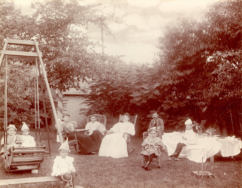
While most of the photographs in the collection were shot by professionals, the photo above was taken by an amateur, F. R. Oesterrich of Detroit. It shows a comfortably prosperous family (perhaps the photographer’s own) relaxing in the back yard, probably celebrating a child’s birthday. The ring toss game might be one of the gifts.

Learn more about Michigan’s Family Album from the Department of History, Arts & Libraries.

Corn Silo

Corn Silo

Corn Silo, photo by Mac Girl.

There isn’t much I can say about this photo other than Mac Girl says it’s near Hudsonville and that it really makes me want to get a Canon EOS Digital Rebel XT … the detail is amazing.

Placidity

Placidity

Placidity, photo by SpringChick.

SpringChick writes:

pla*cid”i*ty (n): 1: a feeling of calmness; a quiet and undisturbed feeling.A thin blue line marks the horizon in a tranquil sea of blue; Lake Superior at Superior Point near the Wisconsin/Michigan border.

Here’s hoping your weekend has all the placidity you need!

Fields of Gold

Fields of Gold

Fields of Gold, photo by Robin of Loxley.

On another photo, Robin of Loxley (aka Brian) writes:

For some reason wheat is the grain of choice this year around Allegan county? This is the first time in the twelve or so years of living here that I have seen ANY of the farmers grow wheat! Really makes for some beautiful golden fields. I have been kicking myself for not getting shots before the harvest…

Walled Lake

walled lake

walled lake, photo by radiospike.

Spike writes: Here’s a handful of pics I took from back in the film days! Remember film?

What do you say? Does anyone remember film?

Sunrise

Sunrise

Sunrise, photo by CaptPiper.

Piper writes I woke up early this morning and decided to go out and hunt for photograhic treasure. As the uploads proceed, you will see what I found.

Sometimes as a photographer, you strike gold.

Be sure to check these out – it’s an amazing series of photos! She also explains a little more about them in her blog.

Star Line Ferry

ZHN15.jpg

ZHN15.jpg, photo by jfsl3.

One of the shots we’re missing from our brand new Destination: Michigan feature on Mackinac Island is a shot of a ferry.

Check out Destination: Michigan for many more great photos of Mackinac Island plus tons of information about visiting the island and its rich history.

40 Mile Point Lighthouse

40 Mile Point Lighthouse

40 Mile Point Lighthouse, photo by midmichphotos

According to the 40 Mile Point Lighthouse Preservation Society, the lighthouse is located on the shores of Lake Huron in Presque Isle County’s Lighthouse Park (about 7 miles north of Rogers City).

In 1889, the Lighthouse Board recommended that $25,000 be appropriated for construction of a new light and fog signal near Hammond Bay on Lake Huron … Major Milton B. Adams, Eleventh District Engineer selected and surveyed a site approximately 40 miles southeast of Old Mackinaw Point and 40 miles northwest of Thunder Bay.

The main lighthouse structure models the Big Bay lighthouse which was being constructed simultaneously near Marquette in the Upper Peninsula. 40 Mile Point is a two-story duplex with a tower incorporated into the center of the side-wall facing Lake Huron. Its footprint measures 35 feet by 57 feet.

Lighthouse photographer Terry Pepper has some great historical information (and photos) about Forty Mile Point Lighthouse in his Seeing the Light.

As a side note, I had to search to find this photo again and the photos Flickr pulled up for a “40 mile point” search are really cool!

#11 at Arcadia Bluffs

Arcadia-No11 boat- 128

Arcadia-No11 boat- 128, photo by Simonds.

This photo is part of a great set of photos that you will probably want to view as a slideshow.

Michigan Golf Magazine says that Arcadia Bluffs offers one the most dazzling collection of golf holes in the United States. Visit the web site for Arcadia Bluffs Golf Course (located about 20 minutes north of Manistee on M-22).