

Untitled, photo by Michael Zz.
Check it out bigger or in Michael’s Night Shots set (slideshow).
Hope your weekend brings you all the fun you can handle and if you’re wondering what to do, check out Absolute Michigan’s Michigan Event Calendar.
Untitled, photo by Michael Zz.
Check it out bigger or in Michael’s Night Shots set (slideshow).
Hope your weekend brings you all the fun you can handle and if you’re wondering what to do, check out Absolute Michigan’s Michigan Event Calendar.

Holland, Michigan Lighthouse, photo by Tony Tanoury.
The Pure Michigan Photo Contest is open until June 29, 2009 and offers you a chance to win prizes including a stay at the Gran Hotel on Mackinac Island!
You can get all the details at the link above and check out submitted photos on their map.
Tony took this photo of the “Big Red” lighthouse in Holland last May. Be sure to check it out bigger and also in his Michigan set (slideshow).

Photo Kayaking on Pigeon River, photo by Fellowship of the Rich.
Here’s a photo taken while kayaking on the Pigeon River in Port Sheldon, about which the DNR says:
The Pigeon River is located in the north-central part of the southern peninsula of Michigan. Its headwaters are located a few miles northeast of Gaylord. The river then flows in a northerly direction to its mouth at Mullet Lake, a distance of 42 miles. The Pigeon River system drains a surface area of approximately 88,000 acres and include 80 linear miles of stream.
The DNR’s Natural Rivers page says that Michigan has more than 36,000 miles of rivers and streams, including over 12,000 miles of cold water trout streams. Get a list of those Michigan rivers from Wikipedia.
Be sure to check this photo out bigger and in Rich’s The River set (slideshow)
Rich also created a new Flickr group called The River, about which he says:
Life stems from flowing water and life grows around flowing water. Cities and towns build up around the river. This group is about documenting rivers from all over the world. Activities in and around the river. From swimming, boating, fishing to taking in scenery and wildlife. Iconic rivers to locally known fishing rivers, we’d love to have them all.

6739 Yellow-footed Chanterelle, photo by darylann
MichiganMorels.com says that the Yellow-Footed Chanterelle is a bright yellow mushroom, this is sometimes funnel shaped and:
Time Of Year: Late Spring through early Summer. Once you find an area that produces chanterelles, go back 2 or 3 times within that month. you just might find they fruit in the same area 2, 3 or 4 times!!
Edibility: Delicious and well respected as one of the best edible mushrooms by nice restaurants as well as harvesters. The chanterelle is one of my favourites and I look forward to it as much as morels. One must use caution so as not to confuse it with the poisonous Jack O Lantern. The Jack will have “normal” gills and fruit off of wood.
Habitat: I find them in mixed deciduous woods where sunlight is allowed to reach the ground. They seem to relate to Oak in my area, but I read that they also relate to Maple, Aspen and Pine.
You can read more at Wikipedia’s Chanterelle entry and even order chanterelle mushrooms from Michigan’s own Wild Harvest.
You can see this bigger in Daryl Ann’s slideshow.

The Portage Lift Bridge I, photo by We Are CS.
There are those who believe that the Portage Lift Bridge in Houghton, Michigan looks like two grasshoppers eating spaghetti. There are also those who believe this structure is worthy of celebration. That annual event happens this weekend (June 19-21) and it’s called Bridgefest. It looks like they pack a lot of fun into this weekend long celebration.
Wikipedia’s Portage Lake Lift Bridge entry says:
The Portage Lake Lift Bridge connects the cities of Hancock and Houghton, Michigan, USA, across Portage Lake, a portion of the waterway which cuts across the Keweenaw Peninsula with a canal linking the final several miles to Lake Superior to the northwest. US 41 and M-26 are both routed across the bridge.
The original bridge on this site was a wooden swing-bridge built in 1875. This was replaced by a steel swing-bridge built by the King Bridge Company in 1901. This bridge was damaged when a ship collided with it in 1905. The center swinging section of the bridge was replaced and a similar incident almost occurred again in 1920, but the ship was able to stop by dropping its anchor, which snagged on the bottom of the lake. In 1959, this bridge was replaced, at a cost of about 11-13 million US dollars (sources vary), by the current bridge which was built by the American Bridge Company.
As its name states, the bridge is a lift bridge with the middle section capable of being lifted from its low point of four feet clearance over the water to a clearance of 100 feet (30 m) to allow boats to pass underneath. The Bridge is the world’s heaviest and widest double-decked vertical lift bridge.Its center span “lifts” to provide 100 feet (30 m) of clearance for ships. The bridge is a crucial lifeline, since it is the only land based link between the north (so-called Copper Island) and south sections of the Keweenaw peninsula.
Be sure to check this out bigger and also have a look at Kyle’s Portage Lift Bridge set (slideshow). More photos of the Portage Lift Bridge on Flickr.

Picture Rock Light House, photo by wlmgram.
The Grand Island East Channel Light entry at Terry Pepper’s Seeing the Light begins:
Grand Island stands at the entrance to Munising Bay, with its south shore long serving as a natural harbor of refuge to vessels seeking shelter from the fury of Superior’s late season storms. So critical was the area considered by mariners that one of the big lakes’ first lighthouses was built on the north tip of Grand Island in 1856, to both warn coasting captains of the northern point of the island and to indicate the safe harbor located to the south. While the lighthouse served both purposes well, it did little to provide assistance to captains making their way through the harbor passages one the east and west sides of the island, through which entry was difficult under conditions of good visibility, and next to impossible under the cover of darkness.
To this end on February 27, 1860, Senator Chandler presented a petition signed by masters, pilots and owners of vessels sailing through the area “praying the erection of two light-houses upon the entrance to Grand Island bay and harbor.”
In addition to being one of the first lights on Lake Superior, it was also one of the first to be decommissioned. Click through to Terry’s site to read on and to see more pictures. He notes that you pass this light if you take the Pictured Rocks Boat Cruise. You can also see a Map to Grand Island light at Lighthouse Friends.
Be sure to check this out bigger and also see Wendy’s slideshow for a few more lighthouse photos.

Great lake, photo by jpwbee.
Earlier this week mLive reported (thanks Michitwitter) that University of Michigan researchers found evidence of ancient hunters at the bottom of Lake Huron:
Using detailed government data on lake floor topography, a research vessel and a remote mini-rover equipped with a camera, scientists found what they believe are hunting pits, camps and rock structures called caribou “drive lines” on the bottom of Lake Huron.
Drive lines, also called drive lanes, are walls built of rocks that hunters used to lure caribou into ambush. A peculiarity of the deer species is that it readily follows linear cues, even though the rock walls are short enough to step over.
The structures were found on an underwater ridge that – about 9,000 years ago – was a land bridge above water. The 10-mile-wide Alpena-Amberley ridge stretches more than 100 miles from near Point Clark, Ontario, to Presque Isle.
The 1,148-foot “drive line” structure found by U-M researchers closely resembles one previously discovered on Victoria Island in the Canadian subarctic.
Click the link above for an underwater photo and be sure to check it out bigger.

Warm Summer Evening, photo by limegreen_kayak
I know that a lot of schools have been out for a while and others are on a year-round schedule, but my school gets out today so I hereby designate today as the official start of summer vacation in Michigan.
As my first act as Summertime Stimulus Czar, I direct everyone to pull out a Michigan map, check out a few likely destinations on Michigan.org & Absolute Michigan and try and create some economic impact for Michigan and fun for yourself!
Check this out bigger in limegreen kayak’s favorites! Here’s Summer in the Absolute Michigan pool.

I was talking with a friend yesterday who had tested their old-school TV and converter kit to see if it would make the jump to the new DTV standard tomorrow (June 12, 2009).
Unfortunately theirs didn’t. If you don’t use cable or satellite, you’ll want to check out “Michigan DTV for Me“, a web site created by the Michigan Television Broadcasters to let you know all about the transition and the scheduled tests to let you know if your television is ready for the digital transition. The tests will be conducted simultaneously on every over-the-air television station in each market.
I doubt the televisions above will make that jump. I also doubt that thy’ll be able to tune in the Wings game! Check them out bigger in b.plus’s slideshow.
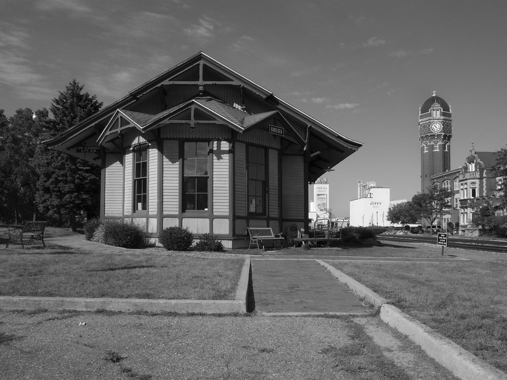
Chelsea Train Station by Jeff & Leyla
Chelsea, Michigan holds its 175th Anniversary Celebration June 25-28 with 4 days of events including a parade, youth activities, contests, music and folks in period costumes – family oriented fun.
This is the space where I would normally tell you something about the history of the town, but even the Wikipedia entry for Chelsea, Michigan has almost nothing. The city of Chelsea has little to say. They did have a link to the Washtenaw County guide entry for Chelsea where I learned:
Chelsea was first settled in 1820 by Cyrus Beckwith, along with Elisha and James Congdon.
Elisha Congdon named the community after his hometown of Chelsea, Massachusetts.
The town was literally “put on the map” when the Michigan Central Railroad built a station here in 1850. UPDATE: Searched for the railroad and found a great Chelsea history page.
Today Chelsea is best known as the home of the DaimlerChrysler Proving Ground and of Chelsea Milling Company’s “Jiffy Mix” brand.
Any other facts or links about Chelsea? Share them in the comments!
Jeff says that left to right you’re seeing the Chelsea Train depot (for rent), Jiffy, the Chelsea Clocktower and the Glazier Stove Co. It’s part of his Chelsea & Dexter set (slideshow). Speaking of slideshows, here’s the Chelsea slideshow from the Absolute Michigan pool.
You can check out some photos of the Glazier Stove Company from the Library of Congress.
