Opening Day 2013: Deer Trail Inn Edition

UP Marenisco Watersmeet MI RPPC 1930s The Deer Trail Inn Saloon & Restaurant DANCING COCKTAILS BEER LUNCHES RED CROWN STANDARD OIL GAS On US-2 Photographer UNK1

Deer Trail Inn Saloon & Restaurant on US-2, photo from UpNorth Memories – Donald (Don) Harrison

Today is Opening Day of the 2013 deer season, and if you’re a hunter I doubt you’re reading this. Almost all of Michigan is potentially open to hunting, so  take extreme care over the two weeks of the November 15-30 Deer Hunting Season.

Confession: I usually root for the deer.

The Toledo Blade reports:

The 2013 “Michigan Deer Hunting Prospects” summary — which is essentially the scouting report on the season – states that deer hunter success in Michigan is sometimes tied to just “being in the right place at the right time,” and that is often the result of being in the field at the peak of whitetail breeding activity. During that fall period, normally ultra cautious bucks will drop their defenses and be on the move much more often.

The state experts say that the 2012 deer season in Michigan was better than the previous year, with hunter success rates showing increases in the Upper Peninsula (UP) and Northern Lower Peninsula (NLP). “Slowly but steadily growing deer populations” in those areas in recent years are credited with improving the harvest.

More than 700,000 deer hunting licenses were purchased in Michigan in 2012, and close to 600,000 hunters took part in the regular firearm season. Overall, deer hunters spent 9.4 million days in the field in Michigan last year, and harvested 418,000 whitetails.

Read on for more and click for the 2013 Michigan Deer Hunting Prospects report.

Check the photo out background big and and check out Don’s massive collection of hunting photos and memorabilia!

The month of the Pleiades … and legendary aurora borealis

Orion Aurora

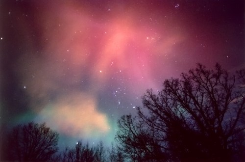
Orion Aurora, photo by Kevin’s Stuff

This EarthSky article on the Pleiades gives some great lore and viewing tips and says that:

In our Northern Hemispheres skies, the Pleiades cluster is associated with the winter season. It’s easy to imagine this misty patch of icy-blue suns as hoarfrost clinging to the dome of night. Frosty November is often called the month of the Pleiades, because it’s at this time that the Pleiades shine from dusk until dawn. But you can see the Pleiades cluster in the evening sky well into April.

You can read much more at EarthSky.org and also might want to check out this story of the Pleiades.

November is also the month of the Aurora, delivering some of the best northern lights action. Kevin took this photo during one of the best solar storms in the last several decades on November 10, 2004. He wrote the following (in part) after viewing these lights:

It was a Dark and (Solar) Stormy Night. Stormy with shafts and rays of light streaming from the heavens.

We all knew there was a chance of another auroral display tonight. We were waiting. And then around 10:30pm or so (from Grand Rapids), the wait was over. This time I went out with my brother, taking back roads and such until we finally found a great spot in northeastern Kent County. We ended up off Old Belding Rd on Lessiter Rd, which is on the way to the Grattan Raceway.

The road faced north, so we were shooting right down the middle of it. There were some clouds around to the north, but nothing too bothersome. Most of the action was to the northeast, with not much seen in the way of color except green, and an occasional red and blue. There were curtains, rays, shafts, and some really good pulsing going on.

I of course used my 35mm film camera, and my brother had his Canon Digital SLR. I was a tad pickier this time, and only shot 3 rolls by the time 1:30 rolled around, and it started to wane. Also, we were getting some clouds coming in, so we bailed.

On the way back to civilization, I noticed it was picking up again … I finally found a place a few miles down the road with a good northern horizon, and set up the camera again.

Oh… My… God. The curtains! The pulsing rays!! The pulsing shafts of light as they flickered up the magnetic lines of force to the corona. I was seeing pulsating shafts from the south!! All of them converging near Orion, forming another spectacular corona. I shot, moved the camera, and shot again. Always looking for the best display, and ever mindful to watch for composition (at least I was keeping my photographers’ hat on during this), I shot frame after frame. At one point I was going to leave, as it was dying again. But as I put my camera in the car, it flared up to the point I HAD to get set up again; another roll of film in the camera. I finally stopped around 3:00, as it was dying down, and also because I knew if I didn’t force myself, I’d shoot until I ran out of film. … In all my years of observing the aurora, I’ve never seen such intense pulsating effects. Also, the coronas (all 5 I counted) had more detail in them than I had ever seen.

Check his photo out bigger with Kevin’s helpful note showing the Pleiades cluster in the top right and see more including a few more from November 2004 in his Aurora slideshow.

More of the night sky on Michigan in Pictures.

Seul Choix Pointe Lighthouse is your only choice

Seul Choix Lighthouse, MI

Seul Choix Lighthouse, MI, photo by Wrong Main

We’ve covered the Haunting of Seul Choix Lighthouse on Michigan in Pictures. Dave Wobster has an article on Seul Choix Light at Boatnerd.com. He writes that Seul Choix (“only choice” as the only safe harbor in the area) was popular with Native Americans as early as the 1600s due to the abundant  whitefish and lake trout that were waiting to be caught in Lake Michigan. A fishing village was established in the  mid 1800s and a trading post around 1850.

The early navigation aids along the northern Lake Michigan coast were the lighthouses at St. Helena Island (1872) and Peninsula Point (1866). This left a 100-mile gap of dark shoreline with Seul Choix Bay located near the middle. Efforts were soon started to have a lighthouse constructed on Seul Choix Point. The efforts were successful in 1886 when Congress appropriated $15,000 to build a light tower and fog signal on the point. Another $8,000 was added before the project was completed. Various complications and the rebuilding of the original tower delayed completion of the station.The light was first shown in August, 1892, but the complex was not completed until 1895 with the finishing of the fog signal building. The complex consisted of the present conical 78-foot tower and attached 2-story keeper’s dwelling, a steam fog signal building, stable, boathouse, two oil storage buildings, a brick privy, and boat dock and tramway to the fog signal building.

The keeper’s dwelling was expanded in 1925 with a lean-to addition to the west side. The interior living space was divided with a wall to provide equal space for an additional family. The wall has since been removed, but the building still contains two kitchen areas. Particular attention should be paid to the unique rounded gables on the east end of the dwelling. While they are reminiscent of a sailing schooner stern, history does not provide a reason for this detail.

The 78-foot high white conical tower is the typical elaborate “Poe-Style” named after General Orlando M. Poe who provided the original design. The Poe-style light towers are easily recognized by the ornate brackets which support the gallery around the lantern room and the four windows below the gallery which have semi-circular stone arch head pieces.

Read on for more including some photos of Seul Choix details at Boatnerd.com. The Seul Choix Pointe Lighthouse is maintained by the Gulliver Historical Society and you can get a lot more info (and a snippet of a cool song that plays when you load) at their site.

Bill took this shot in 1997 with Plustek OpticFilm 7600. He writes that Seul Choix is located on the north shore of Lake Michigan a little east of Manistique. View his photo background big and see more in his great Lighthouses slideshow.

Many (many) more Michigan lighthouses at Michigan in Pictures!

Michigan Wine Photo Contest

vineyard path

vineyard path, photo by aimeeern

The Michigan Grape & Wine Industry Council says that Michigan has 2,650 acres devoted to wine grapes, making Michigan the fifth state in wine grape production in the nation. Our vineyard area has doubled in the past decade, and Michigan’s 101 commercial wineries produce over 1.3 million gallons of wine annually, good for 13th in wine production. Wine touring & wineries are attracting over 2 million visitors annually, and the chief way our state tells the story of our wines & wineries is through Michigan Wine Country Magazine.

The folks at the Wine Council are seeking your help in telling that story through the Michigan Wine Country Photo Contest. Entry runs through November 26th and you can enter 1-10 photos of Michigan vineyards, wine, wineries or tasting rooms for a shot at the 2014 cover of Michigan Wine Country and one of two grand prize wine touring packages! Click that link for all the details.

Check Amy’s photo out background bigtacular and see more in her great vineyard slideshow.

Much more Michigan wine on Michigan in Pictures!

View of Manitou Islands from Sleeping Bear Dunes

View of Manitou Islands from Sleeping Bear Dunes

View of Manitou Islands from Sleeping Bear Dunes, photo by jess_clifton

Last week’s Leelanau Enterprise is reporting that October 2013 had the lowest number of Sleeping Bear Dunes visitors in a decade – an impressive testimony to the impact of our recent government shutdown. You’ll be able to read the article in a month … when it’s no longer news I guess.

Jess took this from the Pierce Stocking Drive a week ago. Check it out background bigtacular and see more in her Sleeping Bear Dunes slideshow.

More dunes on Michigan in Pictures.

Farmers’ Almanac calls for cold & snowy winter 2013-2014

Snowfall: Scenic Drive

Snowfall: Scenic Drive, photo by marylea

In Farmers’ Almanac prediction: valid winter forecast or ‘darts at a dartboard’?, the Great Lakes Echo explores the accuracy of the venerable Farmers’ Almanac, writing:

…this year, like many before, bloggers, newspapers and local TV stations alike are abuzz with the Almanac’s prediction for winter 2014 – particularly a notably bitter, cold, precipitous winter for the Midwest and most of the Great Lakes region.

“This winter is shaping up to be a rough one,” the almanac reports.

So how much weight does this prediction hold?

“The value of the Farmers’ Almanac in terms of weather forecasting is no better than a comic book,” says Detroit-based meteorologist Paul Gross. “If we knew the forecast a year in advance, we’d be utilizing that knowledge by now.”

The Almanac, which famously keeps its weather predicting methods rather hush-hush, claims to be 80 percent accurate – although the lack of concrete evidence proving that claim draws some skepticism.

The Almanac also makes a questionable remark about the relationship between global warming and a winter with heavy snow.

“Brrrrr!” says the excerpt. “It looks like global warming will soon be taking a vacation to make room for Old Man Winter.”

Heavy snow in winter means quite the opposite in regards to global warming, says Gross. “What people don’t understand is that global warming means that more ocean water is evaporated into the atmosphere,” he said. “And that water vapor in the atmosphere is what becomes available to storms to create precipitation.”

Global warming isn’t “taking a vacation” to make way for the heavy precipitation, Gross said. Rather, a warming climate cause increased precipitation. “It’s shocking, but four of Detroit’s top 10 snowiest winters in history have occurred since 2002,” he said.

They add that the Almanac’s prediction does appear to be somewhat in line with predictions like the National Oceanic and Atmospheric Adminstration’s. Read on for more at the Echo.

Check Marylea’s photo out bigger and see more in her Winter 2011-2012 slideshow.

More weather on Michigan in Pictures.

A Lake, a Lady and a Legend

Sky and Fanny Hooe

Sky and Fanny Hooe photo by dcclark

Lake Fanny Hooe is located in Fort Wilkins State Park on the Keweenaw Peninsula near Copper Harbor. A great article from Marquette Monthly about the hard life of UP women back in the day tells about how the legend of the lake turns out to be a lot more dramatic than the reality:

Local tales related that the beautiful young woman had drowned in the lake, or got lost in the woods while picking blueberries and was never seen again. In truth, Lucy Frances Fitzhigh Hooe, Fannie, spent the summer of 1844 visiting her brother Thornton, who was stationed at Fort Wilkins. Her sister, Richardetta was the wife of Lt. Daniel Ruggles, also stationed there. At the end of the summer, she returned to the family home in Virginia. She then married Chester Bailey White in 1849, and had three children. While she led an interesting life, her visit to Fort Wilkins was not a major part of it. She died in 1882, probably in Fredericksburg, (Virginia).

Read on for lots more!

Dave took this photo from Brockway Mountain Drive, looking towards Copper Harbor and Fanny Hooe. See it bigger and see more in his Copper Country slideshow.

100 Years after the Great Storm of 1913

NovemberGaleGrandHaven-2

NovemberGaleGrandHaven-2, photo by Rich Wyllis

100 years ago today the most devastating storm in Great Lakes history began. It raged across the Great Lakes from November 7-10, 1913. As NOAA’s commemorative website explains:

In November of 1913 the Great Lakes were struck by a massive storm system combining whiteout blizzard conditions and hurricane force winds. The storm lasted for four days, during which the region endured 90 mile per hour winds and waves reaching 35 feet in height. With only basic technology available, shipping communication and weather prediction systems were not prepared for a storm of such devastating force. When the skies finally cleared, the Great Lakes had seen a dozen major shipwrecks, an estimated 250 lives lost, and more than $5 million in damages (the equivalent of more than $117 million today).

Nicknamed the “White Hurricane” and the ‘Freshwater Fury” the 1913 storm remains the most devastating natural disaster to ever strike the Great Lakes. One hundred years later, NOAA commemorates the Storm of 1913 not only for the pivotal role it plays in the history of the Great Lakes but also for its enduring influence. Modern systems of shipping communication, weather prediction, and storm preparedness have all been fundamentally shaped by the events of November 1913.

Head over to NOAA for more on the weather technology of 1913 and today and definitely check out more on the Freshwater Fury on Michigan in Pictures!

Check Rich’s photo out bigger and see more in his slideshow.

Bent Trees at Sleeping Bear

Bent tree forest ... II

Bent tree forest … II, photo by Ken Scott

One of my favorite photographers (Ken Scott) was featured Monday on one of my favorite blogs (NASA’s Earth Science Picture of the Day). Via the EPOD:

During a hike late this summer I noticed the oddly bent trees shown above in Sleeping Bear Dunes National Lakeshore, Michigan. It’s likely that snow loading or extreme icing from big storms during a previous winter caused this bowing. These trees were perhaps big enough to bend but not yet so inelastic as to break beneath heavy the snow/ice load. In subsequent years, with less damaging weather conditions, their crooked trunks may begin to straighten. Photo taken on September 21, 2013.

Check Ken’s photo out bigger and see more including another view in his Sleeping Bear Dunes National Lakeshore slideshow.

If you have photos of interesting natural phenomena, consider submitting them to the EPOD!

Stand up tall and vote

VOTE!

VOTE!, photo by ktpupp

This is a frightening statistic. More people vote in ‘American Idol’ than in any US election.
~Rush Limbaugh

You’ll become a statistic whatever you do today. Here’s hoping you become one of the statistics who took a little time to make decisions about your community.

Check K.T.’s photo out background big and see more in her slideshow.