The Ice Caves of Leelanau

IMPORTANT SAFETY UPDATE! The Leelanau County Sheriff’s Department has declared the ice caves on Lake Michigan unsafe!! The winds have moved the ice and there is now open water within feet of the caves, and the strong winds expected today and tomorrow will continue to push water and ice inland. There are also large cracks in the arches and they are expected to start collapsing soon.

Lake Michigan … ice cave sunset II by Ken Scott

Ken Scott took a trip out to the massive ice caves off the shore of the Leelanau Peninsula near Traverse City. You can see a fantastic video of his explorations and should definitely take a minute to watch his cautionary video showing the cracks that can form in these massive structures. There are few things less forgiving than the Great Lakes in winter, and with temps forecast in the upper 30s for tomorrow, things could get very dangerous.

View Ken’s photo bigger and see more in his Ice Cave slideshow.

Although ice caves and similar formations form every winter on Michigan’s shoreline, these ones are particularly incredible due to the greater than normal mass of ice generating more force. They have made it all the way to national news and have drawn thousands of visitors. A couple more features are at Huffington Post, another nice YouTube video showing the structures and the crowds and this mLive article with directions.

So cold the ice is blue

Blue Ice

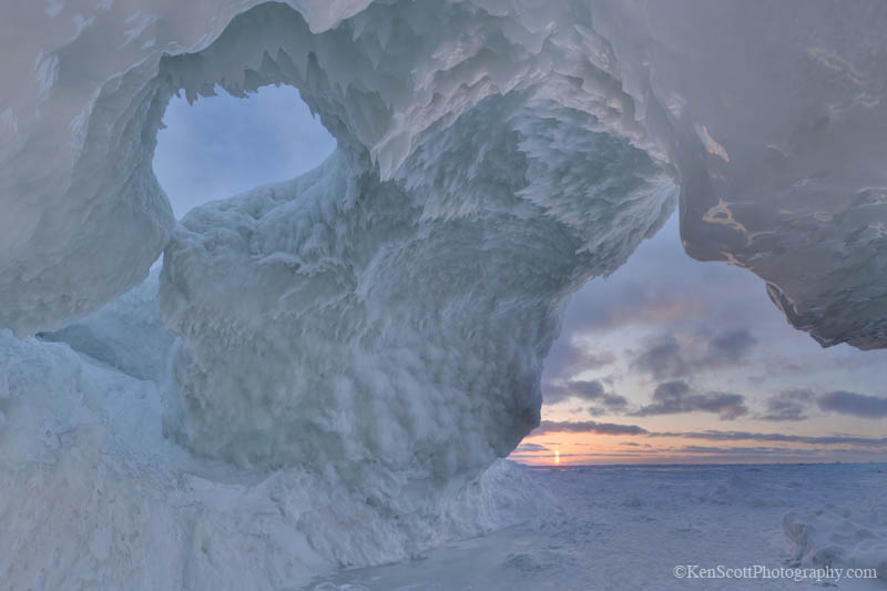
Blue Ice, photo by HLHigham

You may have seen one or more of these incredible ice photos making the email round as Lake Michigan or Lake Huron ice. The Snopes.com article above says that they and many more were taken Antarctic base of Dumont D’Urville by Tony Travouillon in 2002. A shout-out to TC weatherman Joe Charlevoix who posted a story earlier in the week debunking the hoax!

While we don’t have that level of brilliant blue, our ice does get bluish. Via Shawn Malone at the Earth Science Picture of the Day, I found an informative article by Larry Gedney about blue ice & snow that says:

It is a common misconception that the blue color exhibited by glaciers, old sea ice, or even holes poked into a snow bank is due to the same phenomenon that makes the sky blue–light scattering. But nature has more than one recipe for producing the color blue. In frozen water and in the sky the processes are almost the reverse of each other.

A blue sky results when light bounces off molecules and small dust particles in the atmosphere. Because blue light scatters more than red does, the sky looks blue except in the direction of the sun (particularly when the sun is near the horizon and the blue light is scattered out of the sunlight, leaving the red color of sunrises and sunsets).

When light passes through ice, however, the red light is absorbed while the blue is transmitted. Were the operating process scattering as in the atmosphere, then the transmitted light would be red, not blue. However, because of the large size of snow grains and ice crystals, all wavelengths of visible light are scattered equally. Scattering therefore does not play an appreciable role in determining the color of the transmitted light.

It takes an appreciable thickness of pure ice to absorb enough red light so that only the blue is transmitted. You can see the effect in snow at fairly shallow depths because the light is bounced around repeatedly between ice grains, losing a little red at each bounce. You can even see a gradation of color within a hole poked in clean, deep snow. Near the opening, the transmitted light will be yellowish. As the depth increases, the corer will pass through yellowish-green, greenish-blue and finally vivid blue. If the hole is deep enough, the color and light disappear completely when all the light is absorbed.

The color of ice can be used to estimate its strength and even how long it has been frozen. Arctic Ocean ice is white during its first year because it is full of bubbles. Light will travel only a short distance before it is scattered by the bubbles and reflected back out. As a result, little absorption occurs, and the light leaves with the same color it had when it went in.

There’s more (lots more) on water, snow & ice from the University of Alaska, Fairbanks.

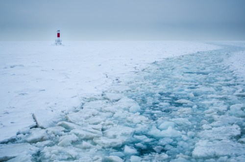
Heather took this photo at Point Betsie last weekend. View it bigger and see more in her Winter slideshow.

More science on Michigan in Pictures and speaking of ice, check out the ice caves off the Leelanau Peninsula in this mLive feature & video.

Detroit Tigers pitchers and catchers report!

IMG_0025

Untitled, photo by hueytaxi

You can keep your groundhogs. THIS is a real sign of Spring! Yesterday was the deadline for pitchers and catchers to report to spring training in Lakeland, and things start in earnest next week. The 2014 Detroit Tigers schedule says they have their first game on the 25th and open the season at Comerica Park on March 31st vs the Royals.

The Freep has an interesting article comparing new Tiger’s skipper Brad Ausmus to legendary Tiger manager Mickey Cochrane. A fun fact I learned is that Mickey Mantle was named after Cochrane.

Roger Dewitt aka hueytaxi is my go-to for Tiger spring training photos. View his photo from last year background big and see LOTS more in his Detroit Tigers spring training slideshow!

More Tigers on Michigan in Pictures.

Great Lakes approaching record ice cover

Leland & Lake Michigan by Elijah Allen

Drone over Leelanau (at Leland), photo by Elijah Allen

Mark Torregrossa writes at mLive that the Great Lakes are nearly 90% ice-covered:

The total ice cover on the Great Lakes continued to increase in the past seven days. At the rate the ice is growing, ice cover would reach record levels sometime next week.

We also had a mostly clear day Tuesday February 11, 2014. The high resolution satellite was able to generate some fascinating images.

The total ice cover on the entire Great Lakes system is reported at 87.3 percent today, according to the Great Lakes Environmental Research Laboratory(GLERL). The ice cover is up from 77 percent covered seven days ago.

The highest recorded total ice cover on the Great Lakes is 94.7 percent back on February 19, 1979. It should be emphasized that the most modern data set only goes back to 1973.

So the entire Great Lakes system has gone from 77 percent ice covered last week to 87 percent ice covered today. At that rate of increase, the Great Lakes would set a new modern day record for ice cover sometime next week.

Click through to mLive for a Lake by Lake report on ice cover and some sweet satellite shots.

My friend Elijah has been having entirely too much fun in and above the snow this winter. Lately he’s been flying a drone above the Leelanau Peninsula to see what he can see. View his photo bigger and (if you can) see more in his Drone over Leelanau Facebook gallery.

More aerial photography on Michigan in Pictures!

The definition of intensity

The definition of intensity . . .

The definition of intensity…, photo by Dr. Farnsworth

View Dale’s photo from last weekend’s Kalkaska winterfest background big and see more in his winter slideshow.

More winter wallpaper on Michigan in Pictures.

Sweetheart Splash

Rockford Sweetheart Splash 2014

Rockford Sweetheart Splash 2014, photo by DJ Wolfman

I solemnly swear that I will never get tired of looking at polar bear plunge photos. They are Michigan’s Mardi Gras which I think is awesome.

DJ Wolfman captured some great fun at Rockford’s Sweetheart Splash. Check this photo out bigger and see more in his Rockford Sweetheart Splash slideshow.

Icebreaking on the Great Lakes with USCG Bristol Bay

Shipping Lane

Shipping Lane, photo by rellet17

Winter 2014 has been a big challenge to keep up with for road crews and homeowners, and it’s a challenge that doesn’t end at the shoreline!

On Friday, Ross got a chance ride aboard the US Coast Guard Icebreaker Bristol Bay as it opened a path for shipping traffic on Lake Saint Clair. The captain told him the ice has only been this dense one other time in the past 30 years! The Coast Guard says:

The USCGC BRISTOL BAY is one of just two Bay-class cutters that work in conjunction with a special barge. BRISTOL BAY the second of the U.S. Coast Guard’s 140-foot icebreaking tugs. She is named after the body of water formed by the Alaskan peninsula which empties into the Bering Sea. BRISTOL BAY was built by the Tacoma Boatbuilding Co. in 1978. She was commissioned in Detroit in 1979.

Designed by U.S. Coast Guard engineers, the BRISTOL BAY’s primary responsibility is opening and maintaining icebound shipping lanes in the Great Lakes. Bay-class tugs are designed to continuously break at least 20 inches of hard, freshwater ice. The ships can break more than 3 feet of ice by backing and ramming. The Bay tugs have a special hull air lubrication system that helps extract the ship from thick ice and improves ice breaking ability at slower speeds.

View Ross’s photo background bigtacular and see more in his ice breaking slideshow.

PS: A few weeks ago I came across this video of more Great Lakes icebreaking action, showing the Icebreaker Mackinaw and others clearing a path from Sault Ste Marie down the St Marys River that you might enjoy. It was shot from the wheelhouse of the CSL Assiniboine.

There’s more ice and more winter wallpaper to be found on Michigan in Pictures!

ISS Flyover and Flythrough

Downtown Flyover

Downtown Flyover, photo by Kevin’s Stuff

The other night I came across an incredible video tour of the International Space Station by Commander Sunita Williams of NASA before she departed for Earth. It’s one of the most amazing things I’ve ever seen and does so much to make the experience of living, working and moving in space a lot more tangible.

Commander Williams is a big part of what makes this video so engaging. She guides you through the corridors of the space station with a skill for explanation that I have seldom (if ever) seen. If she were born a hundred or so miles to the east, she’d be a Michigander. She wasn’t though, so I guess it might not be true what my grandmother told me about Ohio. Read her blog of the mission at NASA. (great photos)

Kudos to Commander Williams, and to everyone who worked across national and other divisions to make the ISS a reality. This video really made my day and I hope it makes yours – click to watch on YouTube!

About the photo, Kevin writes:

The International Space Station flies through the constellation Orion in the skies over downtown Grand Rapids, Michigan on a chilly and windy October evening.

This was a low pass in the southern sky (maximum altitude 34 degrees) so I decided to drive downtown to see if I could get a shot as the spacecraft flew over the buildings. I had done something similar in March of 2010, and figured if I could do it once, a second time wouldn’t be a problem.

Using timings and coordinates from Heavens Above  via their Android app, I was able to determine where the flyover would begin and end. I set up my camera and did a few test shots before the actual time, and was ready by the time ISS was visible over the south-southwestern horizon.

I timed it so the light from the station would already be in the FOV of the lens, and opened the shutter until it disappeared a short time later. Then it was home to the computer to see if I could make anything out of the image. I guess I did.

Who says you can’t do astrophotography from the city? :)

View his photo bigger and see more in his ISS slideshow.

More nighttime photos on Michigan in Pictures.

Hot Stove League

Comerica Park Winter - Detroit, MI

Comerica Park Winter – Detroit, MI, photo by memories_by_mike

The Freep has an interesting article with Detroit Tiger GM Dave Dombrowski discussing the teams offseason strategy.

View Mike’s photo background bigtacular and see more in his Detroit slideshow.

More Tigers on Michigan in Pictures.

Pictured Blue: Miner’s Castle in the Pictured Rocks National Lakeshore

Pictured Blue

Pictured Blue, photo by Kiiraaan

View this jaw-dropping photo of Miner’s Castle bigger and see more in Kiran’s Landscape slideshow.

The Pictured Rocks National Lakeshore’s Geology Field Notes page has this barely comprehensible stuff to say about Miner’s Castle:

The Miners Castle Member is a soft, crumbly, quartz sandstone (with abundant garnet content) about 140 feet thick; its complete section is exposed in the Pictured Rocks Cliffs between Sand Point and Miners Castle. Sediments of this member are generally poorly sorted.

Capping the easily eroded Miners Castle Member of the Munising Formation in the western half of Pictured Rocks, is the resistant Early Ordovician (480-500 million years old) Au Train formation. The Au Train Formation is a light brown to white dolomitic sandstone that forms the resistant cap to the underlying softer sandstones. The numerous falls in Pictured Rocks National Lakeshore are the result of this caprock.

Read on for much more about the geology of Pictured Rocks. Erosion is indeed a factor with one of the most visible instances being April 13, 2006, when one of the pillars of Miner’s Castle collapsed.

You can see more of Pictured Rocks from Absolute Michigan and at the Pictured Rocks National Lakeshore web site.