Silver Lake Dunes in black & white

Untitled

Untitled, photo by Kiran Bhat..

The Sleeping Bear Dunes have gotten a lot of press lately but they’re not the only dunes in Michigan.

Silver Lake Dunes for example.

Check this out bigger and in Kiran’s Ludington & Silverlake slideshow.

More black & white on Michigan in Pictures.

Golden Dunes at Grand Mere State Park

_MG_8420 Golden Dunes Grand Mere State Park

_MG_8420 Golden Dunes Grand Mere State Park, photo by cemillerphotography.photoshelter.com.

Sleeping Bear Dunes have been soaking up all the love in the media lately courtesy Good Morning America naming them the most beautiful place in America.

When I saw these photos I thought they were from Sleeping Bear, then I realized they were from Grand Mere State Park near St. Joseph, which the state of Michigan says is characterized by magnificent sand dunes, deep blowouts and one mile of Lake Michigan shoreline. Another page adds:

The magnificent high-relief dunes in Grand Mere were formed approximately 10,000 years ago during the recession of glacial lakes. They are a natural phenomenon not found anywhere else in the world. Located between Lake Michigan and several inland lakes and unique wetlands, the dunes afford an excellent perspective of the surrounding region. The lakes and wetlands provide a unique ecological area that encompasses the full range of open water aquatic to closed forest terrestrial communities. The wetlands and lakes are significant waterfowl and songbirds migrating areas.

More about Lake Michigan coastal dune structures in this really great Sand Dune Inventory.

Check this out background bigtacular and in Charles’ Grand Mere State Park slideshow.

More dunes on Michigan in Pictures.

Watching the Water

Watching the Water

Watching the Water, photo by derekspacelewis.

I can have 2 photos of the most beautiful place in America in a week, right?

Check it out background big and in Derek’s Sleeping Bear Dunes slideshow.

Michigan’s Sleeping Bear Dunes is the most beautiful place in (Good Morning) America!

Please Just Come
Please Just Come, photo by Happyhiker4


On Leelanau.com yesterday, I reported that the Sleeping Bear Dunes have been named the most beautiful place in America by the viewers of Good Morning America.

Today I’ve been reading here and there of folks who are wondering if in fact the Sleeping Bear Dunes National Lakeshore deserves that distinction. They say a picture is worth a thousand words, so here’s 1600+ pictures of the Sleeping Bear Dunes from the Absolute Michigan pool on Flickr. Even better, here’s the Sleeping Bear Dunes National Lakeshore homepage – take a trip and decide for yourself!

One of my favorite photographers who shoots in the dunes is Mark Lindsay. See this photo bigger and also in his Dunes slideshow.


Superior Dawn at Grand Sable Dunes

"Superior Dawn" - Grand Sable Dunes , Pictured Rocks National Lakeshore

“Superior Dawn” – Grand Sable Dunes , Pictured Rocks National Lakeshore, photo by Michigan Nut.

By curious coincidence, I was just a short distance (at Twelve Mile Beach Campground from where John captured this stunning view of the Grand Sable Dunes. That link can tell you all about this amazing dune structure and I heartily encourage you to visit the Pictured Rocks National Lakeshore sometime soon!!

Check it out big as the BIG lake or in John’s Pictured Rocks National Lakeshore slideshow.

Many more photos from the Pictured Rocks National Lakeshore can be found on Michigan in Pictures!

Happy Accidents at Van Buren Dunes

van buren dunes beach- holga

van buren dunes beach- holga, photo by EllenJo.

Is it cruel or welcome to post photos like this in February? Please discuss below…

EllenJo writes that because her hands were wet it was hard to advance the film, so she ended up with some cool “happy accidents” like this. Check this out bigger in her blue slideshow and I hope your weekend is full of happy accidents!

More about Van Buren Dunes on Michigan in Pictures … more Holga too!

The Legend of Sleeping Bear and the Sleeping Bear

Sleeping Bear Dunes, 1940, photo by Fred Dickinson/Dickinson Photography

As we know, my laziness knows no bounds, so here’s the story behind “the Bear” on the Sleeping Bear Dunes that I wrote for Leelanau.com this morning!

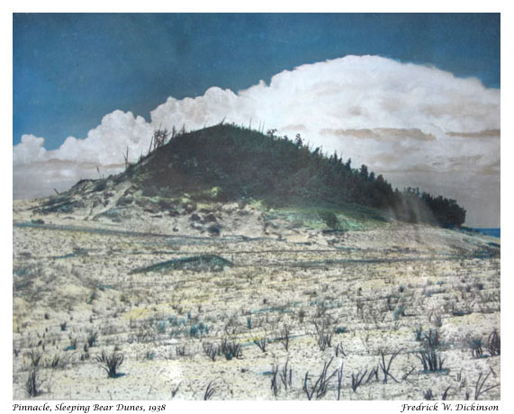
The other day we posted the Legend of the Sleeping Bear to Leelanau.com. After thinking about it, I wondered if folks knew that “the Bear” was also an actual formation atop a dune about a mile north of the Pierce Stocking Overlook. The Sleeping Bear Dunes National Lakeshore says that the formation pictured above known as “the Bear”…

…hardly looks like a bear now, for it has been changing rapidly in recent years. At the turn of the century, it was a round knob completely covered with trees and shrubs. You can still see some of the thick vegetation that gave it a dark shaggy appearance.

…For a long time, the sleeping Bear Dune stood at about 234 feet high with a dense plant cover. However, trough most of the twentieth century, erosion has prevailed. By 1961, the dune was only 132 feet high, and by 1980, it was down to 103 feet. The process is a continuing one. The major cause of the dune’s erosion was wave action wearing away the base of the plateau on which the dune rests. As the west side of the dune loses its support, it cascades down the hill. The wind, too, is a major agent of erosion, removing sand and destroying the dune’s plant cover.

The photo above was taken by Leelanau photographer Fred Dickinson. You can see a closer view right here and definitely check out the Dickinson Photo Gallery to view & purchase great photography of the dunes and other Leelanau spots by Fred and his daughter Grace. On Michigan in Pictures there’s a photo of Fishtown in 1940 that explains Dickinson’s hand coloration technique and another shot by Fred of some folks taking a break from a Sleeping Bear Dune ride.

You can see a couple more photos of the Bear from MSU and don’t forget to click over to Leelanau.com for the Legend of the Sleeping Bear!

Elberta Beach During the Hang Gliding Heydays

Elberta Beach During the Hang Gliding Heydays

Elberta Beach During the Hang Gliding Heydays, photo by jimflix!.

As a payback for yesterday’s icy cruelty, here’s a warm remembrance of summer in the 1970s.

Frankfort & Elberta on Lake Michigan was a hang gliding and soaring hotspot in the 1970s and earlier. Here’s a shot of sailplanes in the 1930s, a little Frankfort-Elberta Area Hang Gliding information and a video of present-day hang-gliding at Green Point Dunes. About this photo Jim writes:

Not a lot of beach that year (and the water was high), so there was not a lot of room to land! Then you had to hope folks would Get Out Of The Way! (And usually they did, as they were mostly hang gliding families or followers.)

Taken at the Elberta beach on Lake Michigan in the late 1970s

Check it out big as the sky and see more in his Hang gliding and hang gliders slideshow!

Wind, Water & Light: Turn your photos into energy

Wind on the Water

Wind on the Water, photo by jimflix!.

GE has an interesting project under their $10 billion dollar Ecoimagination initiative. The Ecoimagination Photo Project lets you upload photos to Flickr tagged with “Wind,” “Water,” or “Light”. For each photo, they donate a certain amount to three related charities to help build fresh water wells, donate solar powered lanterns, and build small-scale wind turbines for communities in need.

Click the photo project link above to see the photos and click for the ecomagination photo project group on Flickr.

Jim took this photo at the Sleeping Bear Dunes National Lakeshore in October. He writes:

Late evening light on the bluffs of the Sleeping Bear Sand Dunes. About 30 minutes after a storm, and there’s still lots of wind coming in. At over 400 feet above Lake Michigan, it takes 30 seconds to run down this bluff, but often takes 30 minutes or more to climb back up! Those are the Empire Bluffs down the coast on the left. And the distant point on the right is Point Betsie.

A complement to this photo, and here’s a photo in the middle.

Check it out background bigtacular and in his Sleeping Bear Dunes slideshow.

Big Sable Point – View From The Top

Big Sable Point - View From The Top
Big Sable Point – View From The Top, photo by pentax hammer (gary syrba)

This is the view from Big Sable Point Lighthouse near Ludington.

View it bigger in Gary’s awesome Summertime slideshow.