

Canadian Freeze Ray encases Mackinac Bridge!, photo by farlane.
Unfolding details of this shocking story at Canadian Freeze Ray wreaks havok on Michigan!!
(and yes, we mention Kwame so it qualifies as news)
Canadian Freeze Ray encases Mackinac Bridge!, photo by farlane.
Unfolding details of this shocking story at Canadian Freeze Ray wreaks havok on Michigan!!
(and yes, we mention Kwame so it qualifies as news)

May I have the envelope for for Best Michigan Snowmobile Photo?
This is part of her great set of Winter photos from the Charlevoix, Petoskey & Mackinac area (slideshow).
Head over to Absolute Michigan for a ton more Mackinac Bridge info.

first impressions, photo by powerbooktrance.
This photo that Terry took of Grand Rapids last night was one of the first I saw this morning.
There’s a lot of people who are featured on Michigan in Pictures who really could have their own photo blog. Because this blog is all about views from everywhere in Michigan, I try to make sure that I don’t feature photos from my favorite photographers too often. That said, I do want to make sure that readers see their work, so I was stunned to find that I’d apparently never posted one of Terry’s photos here.
You can see more of his great long exposures of Grand Rapids and elsewhere (slideshow) including one of my favorites: Moon Patrol.
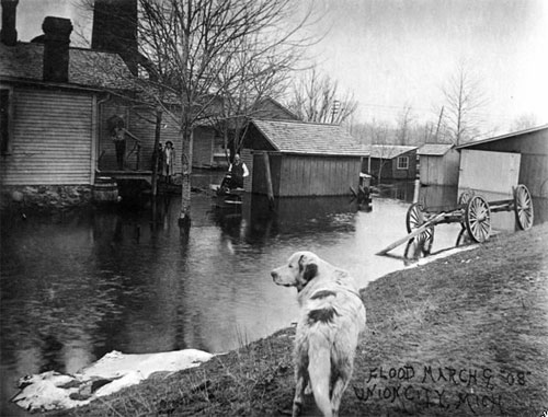
Union City 1908 Flood, photo from UC1960
This photo is one of hundreds of historical postcards from Union City, Michigan posted to a site called Footnote to which I was recently referred. The site has an interesting interface and is one of a growing number of sites that try to leverage the power of social networks (and of course clicky-draggy stuff) to provide a richer experience. In Footnote’s case, they’re focusing on history and the result is pretty cool.
Union City is located south of Battle Creek, where the Coldwater River joins the St. Joseph River (I swear I didn’t plan that tie-in!). In an effort to prove that they have everything about everything, Wikipedia has an entry titled Floods in the United States: 1901-2000 which has this to say about the Michigan Flood of March 1908:
In February, snowstorms had deposited a significant snowpack across the region. Then, in early March, heavy rains and warmer conditions set in, setting the stage for a flood. The Kalamazoo River flooded Albion when the Homer Dam broke around 3 p.m. on March 7. By midnight, the bridges surrounding town were underwater. Six buildings in Albion collapsed, which caused over US$125,000 in damage (1908 dollars).
Union City lost its bridge in the flooding – here’s a photo. You have to see this great photo from the same flood in Battle Creek.

The Bridge Again, photo by mi_kirk.
Kirk says that the trees have grown some since the first time he shot this. You can check out other photos from the Exposure .Detroit Safari to Cranbrook on 08/26/07 (slideshow).
Kirk is one of 5 photographers (tEdGuY49, mi_kirk, radiospike, paulhitz & Bobby Alcott) who will be displaying their work at The Bean & Leaf Cafe in Royal Oak next Friday (Sept 21) from 7-10 PM. Theatre of the Absurd and Liz Larin will provide musical entertainment.
If you’re a person in the metro area who enjoys photography, definitely check out Exposure.Detroit.
The 2010 Mackinac Bridge Walk takes place on Monday, September 6, 2010!
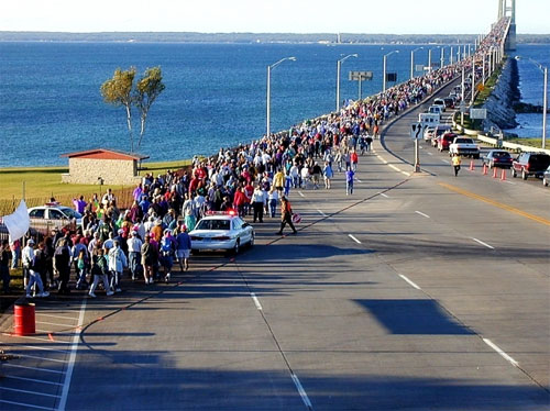
2000 Mackinac Bridge Walk, photos courtesy Michigan Department of Transportation & Mackinac Bridge Authority
The annual Mackinac Bridge Walk has been held every year on Labor Day since the Bridge opened in 1957, so, like the Mackinac Bridge itself, The Bridge Walk is celebrating its 50th anniversary.
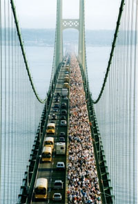 Strangely enough, Wikipedia seems to have the most historical information on the walk (which is not much). They say that the first walk took place in the early morning hours of Labor Day, 1958. and that just 68 people took that first 5 mile walk across the Mighty Mac. In the early years, it seems that the walk was sparsely attended and viewed as an annoyance until the governor was brought in to lead the walk. The walk averages 50,000 to 65,000 attendees and the record is estimated to be 85,000 when George H. W. Bush led the walk in 1992. Will we break the record this year? Seems like we should, but I wonder.
The Governor’s party leads the way at 7 AM (I think) with registered and pre-qualified joggers (details from the Governor’s Council on Physical Fitness). Important things to note (according to the official site) are that traffic still moves across the bridge during the event, that it starts on the St. Ignace side, that they really recommend you figure your return transport out, that it’s FREE (my capitalization) and that there are NO RESTROOMS ON THE BRIDGE (their capitalization).
The Michigan Department of Transportation has a photo gallery from past Mackinac Bridge Walks. A photographer named Chuck contributed one of his photos from the bridge walk to Wikimedia, and he has a nice gallery of Mackinac Bridge Walk photos. A search of Flickr finds some bridge walk pics as well (hopefully more after this year’s walk!). Do you have more links? Post ’em in the comments and please share your story/photos if you walk this year!

I should add that on September 16 from 7:00 – 7:30 AM, there will be a “Bike Across the Mighty Mac” event sponsored by Mackinaw City Chamber of Commerce. If you’re up in the area, there’s also a Truck Parade of Lights from 8-9 PM on September 15th.

Mighty Mac at 50, photo by smiles7.
Here’s a photo from last weekend’s 50th Anniversary Celebration for the Mackinac Bridge. She has another shot of the fireworks on both the Mackinac City and St. Ignace ends of the bridge.
Michphotog has a nice set of photos of the fireworks as well!
Did anyone else make it there? We’d love a report and some more photos.

Mackinac Bridge Tower, photo by A. Runyon.
Amanda assures us that she wasn’t driving.
Head over to Absolute Michigan for a cool look inside the Mackinac Bridge towers and click the button below for lots more Mackinac Bridge info.

The photo by rdmegr was taken from high above the Straits of Mackinac, the name for the narrow passage between the Lower and Upper Peninsulas of Michigan. Lake Michigan is on the left and Lake Huron, the right with Mackinaw City (with a “w”) and the Lower Peninsula in the foreground and St. Ignace and the UP in the distance. It’s part of his Daytrip to Mackinac set of photos. Another photo from his flight to Mackinac of a freighter, the North Manitou Shoal Light and South Manitou Island was also blogged to Michigan in Pictures for general coolness and the fact that I heard his plane fly over my house.
I also have a confession to make: For months, I have been scared of the Mackinac Bridge.
This is distinct from the uneasiness that my mild phobia of falling off the Mackinac Bridge gives me when I drive over it.
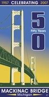 I have been scared because 2007 is the 50th Anniversary of the Mackinac Bridge. To me, other than the lake-etched outline of our state, there is no greater symbol of Michigan than the Mighty Mac.
5 miles long, 552 feet tall in nearly 300 feet of water, the Mackinac Bridge has seen over 120 million crossings required 3 years, over 11,000 people and 4 million tons of concrete and steel to build. (more facts)
And that’s only the barest glimmer of the story that needs to be told. From its conception in the 1800s, through the difficult construction, all the way up to the people who cross it for business or pleasure every day with hardly a pause, the Bridge is an essential part of what joins Michigan’s two peninsulas as one state.
If you have some links to share, please add them in the comments. We’ll be telling the story of the Mackinac Bridge piece by piece here and on Absolute Michigan, and we’ll post links to all the photos, stories and videos on The Mackinac Bridge page at Absolute Michigan. (look for the button!)

Grand Rapids skyline, photo by sparky05.
Web technology like tagging and social networks are increasing our ability to relate our photos to real world data and to relate to each other through our photos.
A great example of this can be found in the ways in which photos of Grand Rapids are woven together. Using Flickr, you can assign locations to your photos. Here’s a photo map of downtown Grand Rapids featurign pictures taken by Sparky and others.
Maps aren’t the only way to connect with photographers (and photographs) of Grand Rapids. Check out the Grand Rapids, Michigan Group on Flickr. Two other good spots are the Grand Rapids Photo Blog and the Grand Rapids forum on UrbanPlanet.org.
Building buffs will also want to head over to the Skyscraper Page for buildings of Grand Rapids. It gives details of all the buildings (including those under construction), drawings of the individual buildings and a lineup of Grand Rapids buildings by height.
All of this may seem like overkill, but consider how incredibly useful this might be to a company that was scouting Grand Rapids (or your city) as a potential location.
