

Lost Horizon, photo by 1ManWithACamera.
Lake Huron from Caseville, Michigan.

Shiawassee River, photo by naokomc.
Poked around the map of Michigan this morning, looking for a place I hadn’t been. That turned out to be the Shiawassee River. (Shiawassee River slideshow)
The very good (if staggeringly bright yellow) page on the Shiawassee River basin from Shiawassee History says:
The Shiawassee River Basin plays a major role in the mid-Michigan area. Its drainage area is approximately 1,200 square miles and portions of the river touch at least 7 counties.
The river is about 110 miles long and generally flows in a northerly direction, which is one of only two or three in the world. The Flint River, Cass River and Titabawassee River join the Shiawassee just southwest of the City of Saginaw and together form the Saginaw River which drains into the Saginaw Bay.
Shiawassee History also explains that Shiawassee may come from the Chippewa term for straight running river; Shiawassee (straight, or straight ahead) wassee. Then again, you can find other sources saying that the name means “river that twists about”.
The Nature Conservancy has a nice page on the Shiawassee River Watershed and the threats it faces from development pressures.
I’ll link to Wikipedia’s brief entry on the Shiawassee River because it had a link to Headwater Trails proposed Shiawassee River Water Heritage Trail (and in hopes that someone can go there and make the entry better).
Update (6/12/07): I just found the Saginaw Basin Land Conservancy who relate that the Saginaw Bay Watershed is the largest contiguous freshwater coastal wetlands system in the United States, featuring more than 175 inland lakes and about 7,000 miles of rivers and streams that are home to large populations of waterfowl, birds, snakes, turtles, amphibians, and more than 138 endangered or threatened species. They’re having a photo contest too – see the comments for details!

Indians.org tells the story of the creation of Mackinac Island’s Arch Rock and says that even now the bravest of the Ottawa people will not walk over it. My favorite Michigan history book, Lore of the Great Turtle by Dirk Gringhuis, says that Arch Rock was the bridge over which departed souls could find their final resting place and also tells another story of its formation due to an angry father, the Sky Person Evening Star and the tears of She-who-walks-like-mist. (seriously, if you have an 8-12 year olf on your gift list, buy them this book)
Wikipedia’s Arch Rock entry takes a more scientific bent, saying that this 149′ limestone arch formed during the Nipissing post-glacial period, characterized by high Lake Huron levels following the end of the Wisconsin glaciation. Arch Rock is one of several limestone formations in Mackinac Island State Park.
I believe that the boat so perfectly posed in the arch is a “mackinaw boat” (photo).
The photo is from the Detroit Publishing Company collection (c. 1899) at the Library of Congress (LC-USZC2-6399 DLC). You can get a larger view at Flickr and a massive 47 MB TIFF at the Library of Congress.
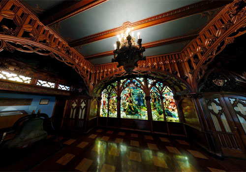
Gothic Room from the SS City of Detroit III, photo by Mark Houston
In celebration of Michigan Week (May 19 – 25, 2007), Mark Houston over at 360Michigan has posted new panoramas from four locations: the National Trout Memorial (downtown Kalkaska in front of the Kalkaska Historical Museum), the Michigan Fireman’s Memorial (near Roscommon), the Manistee River and the Dossin Great Lakes Museum (Belle Isle, Detroit).
All of these are available as full screen, 360˚ QuickTime VR panoramas and are well worth a look, but the ones of the Dossin Museum really showcase the power of the technology.
The 16,000 square foot Dossin Great Lakes Museum is located on Belle Isle in the Detroit River and is dedicated to showcasing the story of the Great Lakes and Detroit’s role in regional and national maritime history. Permanent exhibits at the museum include the Miss Pepsi hydroplane racing boat, the bow anchor of the Edmund Fitzgerald, the S.S. William Clay Ford Pilot House, the restored smoking lounge of the S.S. City of Detroit III and one of the largest known collection of scale model ships in the world.
Mark has also created a Google map showing the location of all his panoramas.

The photo by rdmegr was taken from high above the Straits of Mackinac, the name for the narrow passage between the Lower and Upper Peninsulas of Michigan. Lake Michigan is on the left and Lake Huron, the right with Mackinaw City (with a “w”) and the Lower Peninsula in the foreground and St. Ignace and the UP in the distance. It’s part of his Daytrip to Mackinac set of photos. Another photo from his flight to Mackinac of a freighter, the North Manitou Shoal Light and South Manitou Island was also blogged to Michigan in Pictures for general coolness and the fact that I heard his plane fly over my house.
I also have a confession to make: For months, I have been scared of the Mackinac Bridge.
This is distinct from the uneasiness that my mild phobia of falling off the Mackinac Bridge gives me when I drive over it.
 I have been scared because 2007 is the 50th Anniversary of the Mackinac Bridge. To me, other than the lake-etched outline of our state, there is no greater symbol of Michigan than the Mighty Mac.
5 miles long, 552 feet tall in nearly 300 feet of water, the Mackinac Bridge has seen over 120 million crossings required 3 years, over 11,000 people and 4 million tons of concrete and steel to build. (more facts)
And that’s only the barest glimmer of the story that needs to be told. From its conception in the 1800s, through the difficult construction, all the way up to the people who cross it for business or pleasure every day with hardly a pause, the Bridge is an essential part of what joins Michigan’s two peninsulas as one state.
If you have some links to share, please add them in the comments. We’ll be telling the story of the Mackinac Bridge piece by piece here and on Absolute Michigan, and we’ll post links to all the photos, stories and videos on The Mackinac Bridge page at Absolute Michigan. (look for the button!)


Day 10b, photo by inverness_torch_lake
I can’t help but think that a lot of the photos that have appeared on Michigan in Pictures – and many more by the photographers – should be entered in the Detroit News and WWJ Radio’s Celebrate Michigan photo contest. They say Give us your best shot of the towering pine forests of Northern Michigan or kids frolicking in the dunes along Lake Michigan. We’ll pick the photos that best capture the unique character of our home state.
Entries are due by Friday, May 25, 2007 and the grand prize is (I think) one of three vacation packages at BOYNE resorts (near Harbor Springs), Crystal Mountain Resort (Thompsonville) or Cobblestone Manor Bed & Breakfast (Auburn Hills) and they are also giving away a pair of Tiger tickets a week!
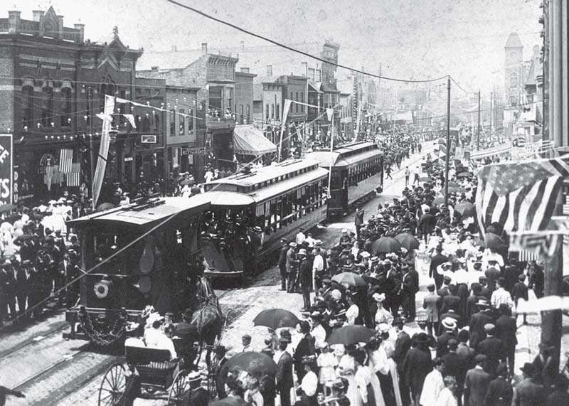
On July 4, 1898, the first Interurban electric railroad car to carry passengers arrived in Holland. The first rails in Holland had been laid by the Holland and Lake Michigan Railway at River (Avenue) and Eighth Street. These cars are on the track a half-block east of there. More than 100 men and 17 teams of horses constructed the line. The payroll for construction workers was $1,000 weekly. The trains ran from Grand Rapids through Grandville, Jenison, Shack Huddle, Jamestown, Forest Grove, Vriesland, Zeeland, Holland, Jenison Park, Macatawa Park, and Saugatuck. The Interurban freight office was on Eighth Street near Pine Avenue. The passenger train continued south on River and turned west on 13th Street. The line continued near South Shore Drive, stopping near Sunnybrook Station at Virginia Park. Extending south near 160th Street, the train headed to Castle Park and Saugatuck. The train met its demise November 15, 1926.
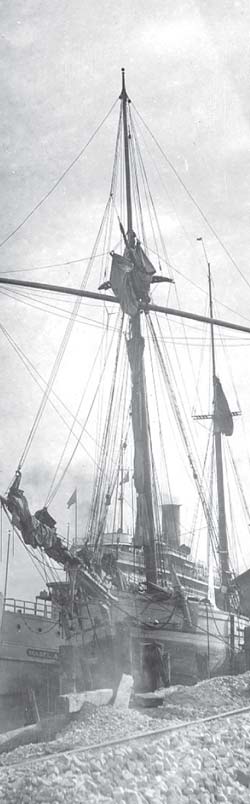
The first time a passenger ship connected Holland directly with Chicago, via Lake Michigan, was July 4, 1889, when the Mabel Bradshaw docked at the foot of Fifth Street at the old Harrington Dock. That first year the ship made four trips a week, leaving Holland on Sunday, Monday, Wednesday, and Friday evenings, after the arrival of trains at 6:35 p.m. The fare was $2 one way or $3.50 round trip. Owner Hugh Bradshaw named the ship after his daughter Mabel. She was to christen the ship with a bottle of champagne. As she reached for the bow, the bottle slipped from her hand and fell into the water, leaving the ship unchristened. The ship was used for a ferrying service a few years later and spent its last years on Lake Superior.
Be sure to click the photos for a larger view!!
Photos reprinted with permission from Holland: The Tulip Town by Randall P. Vande Water. Available from the publisher online at www.arcadiapublishing.com or by calling 888-313-2665.
View other excerpts from Arcadia Publishing’s Michigan books at Michigan in Pictures!

Hulbert Lake, photo by Joslynan.
Josie took this photo in August of 2006 and you can also check out this satellite view of Hulbert Lake and the UP.
Exploring the North’s page on Hulbert Lake says that the lake was also named Lake Glimmerglass by William Hulbert. The page tells an interesting story of William’s grandfather, Francis, who was a “timber cruiser” and raced a fellow cruiser to file for title to the lake in Marquette. He won the race.
When Pine Was King (excerpted from Larry B. Massie’s “Voyages into Michigan’s Past) tells a little more of timber cruising:
The logging cycle began with the timber cruiser. Armed with a map and compass he would tramp the wilderness for weeks seeking prime stands of white pine located near a stream, then race to the nearest U.S. land office to register the find.

Kayaking through the Channel, photo by smiles7.
The lighthouse is the Charlevoix South Pier Light, and it marks the mouth of the Pine River channel that extends from Lake Charlevoix to Lake Michigan. Terry Pepper’s Seeing the Light explains:
The Pine River Channel is believed to be unique in the entire world inasmuch as it has a two-way current. After severe westerly windstorms, waters pushed high into Lake Charlevoix will swiftly flow back out to meet other inbound currents. Small whirlpools and eddies at the harbor mouth are not uncommon, and whitecaps can frequently be observed within the channel on the calmest days.
You can get a lot more information about the history of Charlevoix’s Pier Lights from Terry Pepper and see historical photos including a cool postcard of the Charlevoix North Pier Light in 1909. If you want to visit Charlevoix, the Charlevoix Area Convention and Visitors Bureau is a good place to start.
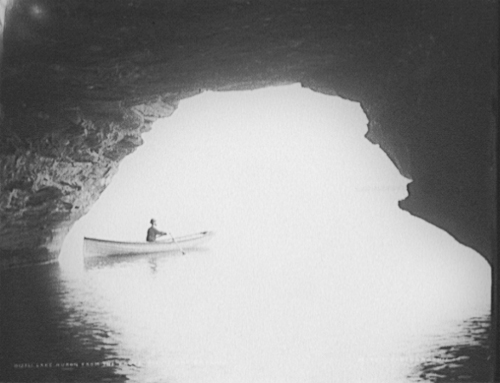
Lake Huron from the caves, Pointe aux Barques
The United States Library of Congress is a shining example of why we need government: to perform the vital work of preserving our heritage. One of the ways you can experience this preserved heritage is through American Memory from the Library of Congress. According to the mission, American Memory provides free and open access through the Internet to written and spoken words, sound recordings, still and moving images, prints, maps, and sheet music that document the American experience. It is a digital record of American history and creativity.
Today’s selection is from a gallery of photos from the collection of the Detroit Publishing Co. taken on and around Lake Huron near Pointe aux Barques and Port Austin in Huron County. It’s a gallery of 20 photos of natural wonders like Turnip Rock and structures such as the Port Austin Reef Light (if that link doesn’t work for you, try the Pointe Aux Barques link on this page).
You can get some great present-day photos of the shoreline at Port Austin Kayak Rental … either in their gallery or by renting a kayak and taking your own! If you have taken any photos of the area, please feel welcome to post links to them in the comments! Port Austin Kayaks also helpfully provided a map link that lets us give you this cool satellite view of the Port Austin shoreline! (I believe that point at the western edge is where Turnip Rock is)
Library of Congress LC-D4-12361
Updated Oct 2, 2008: Check out modern day photos in Kayaking Point Aux Barques!
