Quincy Dredge No. 2 is actually C&H Dredge No. 1

signature

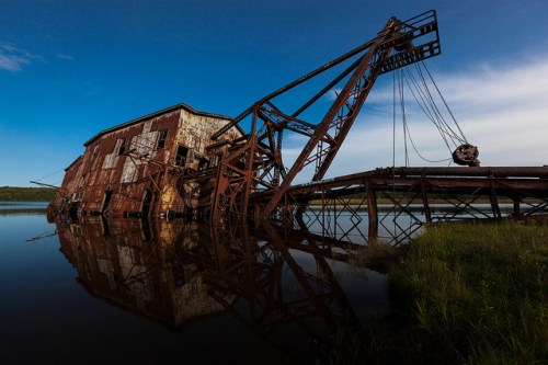
signature, photo by Marty Hogan

The Copper Country Explorer has an excellent feature on The Mining of Torch Lake begins:

Early stamp methodology was a very simple and archaic one – nothing more than a simple process of smashing rock down into small pieces and sorting out the copper. Everything that remained would then be dumped into tailing ponds as waste. In the Copper Country the largest of these tailing ponds was Torch Lake, where no less than five mines dumped millions of tons of waste rock into its depths. Unfortunately, these waste tailings often contained a great deal of copper which the jigs and wash tables of the mills failed to remove. Copper that ended up in Torch Lake.

As copper prices dropped and milling technology improved, mine companies began to take a second look at these copper bearing deposits in Torch Lake. It was now possible – and economically advantageous – for mines to retrieve those tailings and remove the copper that they still contained. The process was known as reclamation, and was first undertaken in earnest by C&H around 1920. Towards that end C&H built itself a dredge that could suck up those sands from the lake bottom and send them out to the reclamation plant on shore. This first dredge – known as C&H Dredge No. 1 – would be responsible for retrieving over 48 million tons of C&H sands in its lifetime, yielding over 423 million pounds of copper for the company.

The Quincy Mine got into the reclamation game several decades later – in 1943 – after failing to make a profit on its underground operation. In 1953 the C&H Dredge No. 1 was bought by Quincy to supplement its own dredge. It turned out to be exceptional foresight, as Quincy’s first dredge ended up sinking in Torch Lake in 1956. Its roof top can still be seen sticking up from the center of the lake. As for Quincy Dredge No. 2, it continued to mine Torch Lake for several more decades until it too sank in 1967.

Read on for a detailed account of the workings of the dredge, lots of views of the dredge and some great historical photos.

Check Marty’s photo out background big and see more in his 2012 August Road Trip slideshow.

More Michigan industry on Michigan in Pictures.

SUP Yo?! Stand-up Paddleboarding at the TC Waterman

SUP Yo?!

SUP Yo?!, photo by Rudy Malmquist

I’ve been doing a lot of stand-up paddleboarding this summer on Grand Traverse Bay courtesy my friend Michael who owns The River of Traverse City. I have been pleasantly surprised at how much fun it is and also what a great workout it is.

In a couple of weeks Traverse City will host the TC Waterman. It takes place on Saturday, August 17th and is the largest paddle board event in the Midwest and also the site of the 2013 Great Lakes Regional Championship. In addition to a variety of races and skills challenges for all ages and skill levels, the event features 50 booths by local and national SUP organizations and companies, free clinics, seminars, and demonstrations. The weekend also features two events from Porterhouse Productions: Paella in the Park on Friday (wine, music & paella) and the Great Wakes Festival Saturday (water-themed activities, organizations, music & fun).

Check this photo out background bigtacular and see more in Rudy’s slideshow.

More Traverse City on Michigan in Pictures.

Grace Dickinson & Leelanau County’s Female Photographers

WomenPhotographers-GraceDickinson-SteamerMissouri

Steamer “Missouri” docked in Leland in 1919, photo by unknown, hand colored by Dickinson Photography

This week’s Glen Arbor Sun has a terrific feature by my friend Kathleen Stocking on Six Leelanau County Women Photographers. She profiles Barbara Nowinski, Kathleen (Dodge) Buhler, Meggen Watt Peterson, Ashmir McCarthy, Marty Schilling and Grace Dickinson. Here’s Grace:

Grace Dickinson has a photo studio across the road from the place her grandparents first came to on the south shore of Little Glen Lake in the summer of 1912. Her grandparents traveled to the Leelanau Peninsula by steamer, from the Navy Pier in Chicago up Lake Michigan to Glen Haven. In 1942 her parents met and fell in love while her mother was a writer/editor at the Leelanau Enterprise and soon after became year-round residents. Grace’s father, Fred, a broker who worked from home, spent his free time photographing the dunes and the islands. One unusual photo shows a cloud the exact size of one of the Manitou Islands, above the island, a rare phenomenon caused by condensation when the temperature of the island is colder than that of the surrounding waters of Lake Michigan.

From an early age, Grace followed in her father’s footsteps, quite literally, accompanying him and sometimes photographing the same scenes. Grace left her studies at Northwestern Michigan College to go on a year-long sailing adventure in the Bahamas, and followed this with a two-decade-sojourn out in Montana where she married a rancher and finished college. Grace returned to the Leelanau Peninsula in the late 1980s and became a mapmaker for the Leelanau County Planning Commission. She began taking photos of the Leelanau Peninsula and opened her own studio out of which she sold her own and her father’s photos and maps. In the mid-1990s she revived the 1930s art of photographic hand-coloring, laboriously hand-tinting her father’s black and white photos of earlier years, photos which evoke the shadows and starkness of some of the photos of Diane Arbus, but as applied to nature, not people. In the medium of hand-coloring Grace discovered a way to keep her father’s legacy alive and express her own love of Leelanau. Her photo studio is on Glenmere (M-22) west of the bridge over the Glen Lake Narrows.

Head over to the Glen Arbor Sun for more! The photo above is labeled as having been taken in Glen Arbor in 1909, but former Leelanau Historical Museum Director Laura Quackenbush identified it as Leland’s dock. The photo was hand-colored by Grace from an old negative on glass found in the Leelanau Enterprise office during the time her parents (briefly) owned it.

If you’re interested in more work bu Grace and her father, head over to Dickinson Photography. I’ve also featured several photos from Fred Dickinson on Michigan in Pictures, and you can click that link to read a little about the coloring process.

On Vacation!

cruising into the sunset

cruising into the sunset, photo by suesue2

Michigan in Pictures will be taking a break this week – see you again on July 1st!

Sue caught the last ferry of the night as it headed to Mackinac Island. Check it out bigger and see more in her Up North slideshow.

Message in a Bottle from Tashmoo Park

tashmoo park

Tashmoo at the Dock, 1900, photo courtesy shorpy.com

The Daily Mail reports on an almost 100-year-old find:

Selina Pramstaller was 17-years-old and Tillie Esper was 23-years-old when they visited an amusement park on Harsens Island in Michigan alongside the St Clair River in 1915 and decided to commemorate the day with a message in a bottle.

That message- ‘having a good time at Tashmoo’- was found almost 97 years later by diver Dave Leander.

Click through for more on the find and some pictures. You can see more pictures and read something about this once popular amusement park on Harsens Island that closed for good in 1951 at waterwinterwonderland.com.

Check this out background bigtacular (or buy a print) and see many more old photos from Detroit and elsewhere at shorpy.com. About the boat, they explain:

The Detroit River excursion steamer SS Tashmoo, a sidewheeler, stopped at Tashmoo Park on the St. Clair Flats on trips between Detroit and Port Huron. A high point in the boat’s eventful 36-year life was the night in 1927 that she broke free of her moorings in a winter storm and headed downriver on her own. Her end came in 1936, when she hit a submerged rock and sank.

Turnip Rock in Lake Huron

Turnip Rock

Turnip Rock, photo by SimsShots Photography

A page about the Point Aux Barques – Turnip Rock geocache had the best information I found about this Lake Huron Landmark. The author explains:

This cache is accessible by a kayak, canoe, jet ski or boat on Lake Huron. Port Austin is the closest harbor which is approximately three miles west. The land around this feature is a gated community. I must stress that this cache is only accessible by a water craft via Lake Huron. If you are not comfortable navigating the waters of Lake Huron, do not attempt to do this cache. Lake Huron can be dangerous at times for small water craft such as kayaks or canoes.

…Everyone that received their grade school education in Michigan learned that glaciers pushed their way over Michigan several times. The result is glacial drift averaging 200 to 300 feet deep covering on top of the bedrock. The thickness of drift has measured over 1,000 feet in a few Michigan locations. Rarely can we see exposed bedrock that has been sculptured by non glacier forces. This is one of the locations in southern Michigan where the sandstone bedrock is exposed at the surface. The amount of shoreline that has exposed sandstone is about one mile, but a lot of beauty has been sculptured in the stone.

The locals call the main structure here “Turnip Rock”, because of it’s shape. Geologists call it a “Sea Stack”. A definition of a sea stack is an isolated pillar-like rocky island or mass near a cliff shore, detached from a headland by wave erosion assisted by weathering. Waves force air and small pieces of rock into small cracks, future opening them. The cracks then gradually get larger and turn into a small cave. When the cave wears through the headland, an arch forms. Further erosion causes the arch to collapse. This causes a pillar of hard rock standing away from the coast. Generally occurring in sedimentary rocks, sea stacks can occur in any rock type.

Read on for more and also see the Atlas Obscura entry for Turnip Rock has a map and photos. Michigan in Pictures favorite Lars Jensen has some great photos of Turnip Rock as well, and you should definitely check out Jason Glazer’s panoramic photos of Turnip Rock.

Check this out background big and see more in Rob’s Landmarks slideshow.

More Michigan landmarks on Michigan in Pictures.

Enjoy your New Year’s Eve!

086

086>, photo by mark5032001

Here’s hoping everyone has a safe & fun New Year’s Eve as we all bid farewell to 2012 and enjoy the first moments of 2013!

View this photo from Bay City’s 4th of July celebration on black and see more in Mark’s photos from Bay City.

Low water exposes Grand Haven shipwreck graveyard

Grand Haven Shipwrecks

Grand Haven Shipwrecks, photo by Kevin Ryan

mLive has a feature on how our historically low water levels have revealed a number of shipwrecks in Grand Haven:

Maritime archaeologist and director of the Tri-Cities Historical Museum Kenneth Pott said the area around Harbor Island was an apparent dumping zone for abandoned vessels and 1930s aerials held by the museum and the city of Grand Haven show that additional wrecks exist there. If the water line were to recede even more, then more vessels may be exposed.

“We’re quite sure that there are more in the area,” Pott said. “This is something akin to a graveyard for vessels. This is very unusual.”

The wooden sections of the 290-foot steamer Aurora, once the largest wooden steamer on the Great Lakes, and parts of at least four other shipwreck hulks were exposed recently by the low water levels and area residents alerted maritime historians to the find. The Aurora was identified by members of Holland-based Michigan Shipwreck Research Associates and local historians earlier this week.

Read on for more info including the publicly-accessible location. You can also read more about the Aurora right here and see a photo gallery.

Check this out background big and see a couple more views including a nice one of the rough outline of the wreck in Kevin’s slideshow.

More Michigan shipwrecks on Michigan in Pictures.

The Armistice Day Storm of 1940

Chipping ice from the City of Flint

Chipping Ice on the City of Flint, photo by Captain John Meissner

Wikipedia explains that the Armistice Day Blizzard struck November 11  (Armistice Day) and November 12, 1940. The intense early-season “Panhandle hook” winter storm cut a 1,000-mile-wide path through the middle of the country from Kansas to Michigan.  Carferries.com has a great article on The Armistice Day Storm of 1940 that begins:

The “storm” of November 11, 1940 was one of the worst storms in the recorded history of Lake Michigan. In all, the storm claimed 5 vessels, and 66 lives. The storm occurred on Armistice Day, which celebrated the end of World War I in 1918.

The storm hit late Monday afternoon, November 11th, with winds of hurricane proportions. The winds struck suddenly from the southwest at about 2:30 P.M. and were accompanied by drenching rain, which later changed to snow. The winds reached peak velocities of 75 miles per hour, the highest in local maritime history. Telephone and power lines were down by the hundreds around Mason County. Several local firms had “gaping” holes where roofs once were. Trees were uprooted, small buildings were overturned, and brick walls were toppled, causing at least 1 serious injury. Very few places escaped without damage. Ludington, on the morning of November 12th, appeared to be a deserted city.

The Pere Marquette carferry City of Flint 32, attempted to make the harbor but wound up on the beach about 300 yards from the shore. She was ordered by her relief captain, Jens Vevang, to be scuttled to avoid being pounded by the incoming seas. On November 12th, a breeches buoy was strung and 27 year old crewman Ernest Delotowski of 406 First Street, Ludington, was brought ashore. Delatowski made a good portion of the trip in the icy waters of Lake Michigan. As a precautionary measure, he was taken to Paulina Stearns Hospital and was released later that day. He said he carried a message with him, but it got lost in the water. Later the buoy was used to carry a message to the ship, and then crewman Luther Ryder of S. Washington Avenue (Ludington) was brought ashore.

You can read more including first-hand recollections of the storm and also see more photos taken by Captain John Meissner and also photos of the grounding and other wrecks as a result of the storm at carferries.com.

More shipwrecks on Michigan in Pictures.

The Great Storm of 1913 at Pointe Aux Barques

The U.S. Life Saving Station, early 1900s, photo courtesy Pointe Aux Barques Lighthouse Society

Glen Willis of the Pointe Aux Barques Lighthouse Society has an excellent article on The Great Storm of 1913 that explains that most historians agree that the most significant and most dreadful storm on Lake Huron took place over the weekend of November 8-10, 1913. Known by all mariners simply as “The Storm”, it was first detected on the western end of Lake Superior on Thursday, November 6th then progressed rapidly south and east, dropping temperatures and spawning marine warnings.

At Pointe aux Barques as the temperature dropped, it began to rain. As the wind picked up the rain turned to sleet. The sleet began to ice up everything it touched. The waves offshore quickly reached 10 to 12 feet, and then more. Then the snow came, thick and wind driven. Shipmasters out on the lake were finding sailing conditions that were unlike any they had seen before. The sleet that had coated their vessels turned the pilothouse windows opaque. It sealed and froze the doorways. To step outside a cabin meant that the skin would be painfully pelted by frozen bits of sleet & snow…

By midday Sunday at Pointe aux Barques, the snow was so thick and so heavily driven by the wind that vessels out on the lake could not see the rays of the light. At nearby Harbor Beach waves had already destroyed some lakefront buildings and had run the 552-foot D.O. Mills ashore. At mid-lake the wheelsman on the 500 foot Howard M. Hannah, Jr. found that the forward motion of the ship had ceased and that the bow had fallen off into the trough of the waves. Without enough power to drive it the ship was at the mercy of the elements. Waves were higher than the ship is tall and as they crashed down upon the ship the windows and the cabins were stove in. The ship was not under command and as it drifted into Saginaw Bay the master could see the flash of the Port Austin Reef Light. He then knew that his ship would not be saved.

Read on for much more and also check out several articles on the deadliest storm in Great Lakes history on Michigan in Pictures and Freshwater Fury on Absolute Michigan.

Pointe aux Barques is the oldest continuously operating Light on the Great Lakes, and the Pointe Aux Barques Lighthouse Society preserves the light and operates a museum. Visit them for more!

More shipwrecks on Michigan in Pictures.