

Gotta view it bigger … and here’s hoping that you get out and make your own footprints on Michigan’s shoreline sometime soon.

Oh yes, more ice., photo by {D}.
{D} says when life give you lemons…
I think the rest is “…you take ridiculously cool pictures of ice that make amazing wallpaper and really should be viewed large”!
This is part of her great Snow/Ice photo set (slideshow).

Strolling in the sand., photo by photoshoparama.
We interrupt this wild winter weather for a special message from Michigan’s beaches who remind you that – despite all appearances to the contrary – winter is not forever and they will soon return with an all-new season of sun, sand and summer fun!
Thanks to Daniel (and Quentin) for the reminder from Grand Haven State Park in April of 2007. Be sure to click to the super-size for the full, glorious effect!
We now return to Winter, already in progress…

Lone tree on a winter beach, photo by norjam8.
This photo was taken and is part of Norm’s set of Winter photos, a very cool set that includes photos like this amazing shot of “Big Red” aka the Holland Harbor light.
Like pretty much all of Norm’s photos, this one is available in super-biggie wallpaper size. I think that’s a beautiful thing.

This photo is from the Explore Michigan group on Flickr that seeks to promote Michigan photographers and the people that travel Michigan in search of its beauty. They are planning events that will take members all over Michigan, so maybe drop by and check them out.
This photo is from Dane’s Random Detroit set (slideshow). It made me wonder what it is about Lake St. Clair that encourages this sort of ice pileup. Current? Prevailing east winds? The Lake St. Clair Monster? Then I realized that a a photo of a similar jam on Lake St. Clair from Michigan in Pictures last year had the answer.
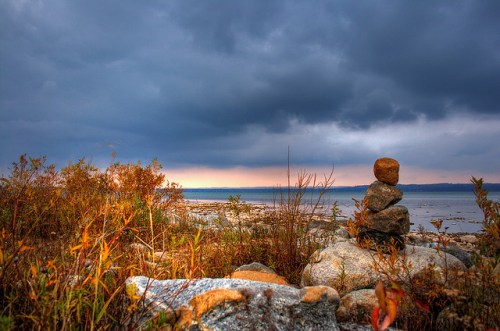
stacked, photo by The Real Ferg.
Ferg took this @ Deepwater Point Natural Area. The Grand Traverse Regional Land Conservancy says Deepwater Point is a 15 acres property is owned by Acme Township on East Bay, north of Traverse City. The plaque reads:
In memory of Clyde H. Reed
Who along with his neighbors fought to protect Acme Township’s Deepwater Point Area – a place precious and dear to him. May we follow his example by being good stewards of this beautiful land for the benefit of future generations.
When I saw this photo, I realized that I had never shared on Michigan in Pictures something that I saw this summer. We called it the Amazing Frankfort Rock Gallery. I spend a ton of time on Michigan’s beaches, but this summer I seemed to see these rock structures everywhere. I wasn’t the only one either.
Anyone in the audience have any idea what’s behind this rock-stacking mania in Michigan?

In the Michigan Immense Public Park, photo by Andy McFarlane
Welcome to a “Soapbox Saturday” on Michigan in Pictures, where your host takes you a little ways past “ain’t it cool” towards “ain’t it a shame.” Don’t worry though – it’s still cool. If it doesn’t seem cool – please click the photo above. I figured that since I was going to be sharing some personal feelings, I probably should use one of my own photos. This photo of my daughter exploring something on the Lake Michigan beach was taken a few years ago at the base of Pyramid Point in the Sleeping Bear Dunes National Lakeshore. I had posted it in gratitude to the Michigan Supreme Court for upholding our right to walk the Great Lakes shore.
Flash forward to the present day when Michigan’s regulators appear poised to permit the first metallic sulfide mine in Michigan. Several years ago, my friend Dick Huey and a few others started a group called Save the Wild UP when Kennecott Minerals, a subsidiary of mining giant Rio Tinto (one of the world’s largest polluters), began the process of securing a permit for a sulfide mine north of Marquette. The proposed mine is located directly under the Salmon-Trout River on the wild and beautiful Yellow Dog Plains. This is state land, our land, and the Salmon-Trout flows just a few miles through it and then empties into Lake Superior. Over that time I’ve been working for them to maintain their web site and have learned a thing or two about “acid mining”.
Iron and copper mining are things that helped forge the character of the Upper Peninsula. You can think of traditional mining as picking the chocolate chips out of a cookie. Sulfide mining is like getting the sugar out of a cookie – a chemical rather than mechanical process that yields a dust as a by-product. If this dust mixes with water and air, it forms sulfuric acid aka battery acid. There has never been a sulfide mine with the potential to pollute ground or surface water that failed to do so. Sulfide mining has polluted 40% of the watersheds in the West, and you can read more of the facts about metallic sulfide mining at Save the Wild UP (has a nice video if you prefer).
 A process with 100% failure rate of protecting water located directly under a pristine river that flows into the largest body of freshwater in the world seems like a bad idea. When you realize that they also plan to blow the sulfide dust into the air and that there are hundreds of other prospected sites waiting in the wings, it becomes terrifying. Michigan and the UP have a lot of challenges right now, but something we do have going for us is our water and wild places and the tourism dollars and jobs they generate. The picture to the right is a result of sulfide mining from Sudbury, Ontario. Multiply that across Michigan’s Upper Peninsula and consider how many thousands of tourism jobs and millions of tourism and tax dollars might be lost.
One of the people who has considered this is a wonderful musician named Daisy May. She has donated a song called A Letter from Downstream to Save the Wild UP and I hope you take the time to listen to it and see the photos that folks have shared about what Michigan’s water means to them.
If you’re a Flickr member, consider adding a photo to the Downstream group.

Leelanau fall, photo by Jeff Lamb
Our next stop (as designed by Travel Michigan) is the region of Northwest Lower Michigan containing Traverse City – Northport – Frankfort. I know this is the second day in a row with a photo from the Leelanau Peninsula … I guess sometimes I feel like hanging around my home. Jeff Lamb likes hanging around here too, especially in the fall, and I think he’s one of the best at capturing the roll of the hill and sweep of the sky that characterizes fall in this part of Michigan. See more in his Leelanau set (slideshow).
 The tour starts at the end of the Old Mission Peninsula at the Mission Point Lighthouse. I’m not sure how you start there – airlift probably. I am sure that you’ll see great color along the winding roads of Old Mission like in this photo Old Mission, MI by Jerry Ting. In addition to being prime fruit growing regions packed with roadside stands and markets, both peninsulas feature great wine trails with about 20 wineries – learn more from the Wineries of Old Mission Peninsula and the Leelanau Peninsula Vintners Association web sites.
Downtown Traverse City has a ton of restaurants and shops to choose from and if you like historic homes, consider wandering the tree-lined neighborhoods of the city and also the Village at the Grand Traverse Commons as there are some gorgeous trees and cool shops to be found there as well! If you want more options, check out the Traverse City CV’s color tours of the region (they also provide regular color reports). One tour they suggested is a northwest Michigan apple tour.
Assuming you’re still with us, lets head north to Leelanau County. M-22 winds along the outside of the county along Lake Michigan through the villages of Suttons Bay, Omena, Northport, Glen Arbor & Empire. From Northport, consider a short jaunt to the beautifully restored Grand Traverse Lighthouse Museum at the tip of Leelanau. On the way back stop in at Kilcherman’s Antique Apple Farm (also see this article) for a huge selection of rare & tasty apples and cider. At the southern end of Leelanau County is the Sleeping Bear Dunes National Lakeshore. With historic farms and hiking trails & overlooks offering soaring views of fall’s glory, this could be a whole weekend in and of itself. Before we leave, I better put in a plug for my Leelanau.com web site as a travel & information resource and also point you at my favorite trail: the Empire Bluff Trail. One look at a collection of photos from Empire Bluff should be all the push you need to take this short but amazing trail!
 Heading south on 22 we enter Benzie County. The photo to the right (Another Autumn at the Tweedle Barn by John Clement Howe) is from the Tweddle-Treat farmstead that’s just off 22 on Norconk Rd). If it’s not to cold, head down to Otter Creek Beach (aka Esch Rd). Further down 22 we pass Crystal Lake and also the 2nd most photographed lighthouse in the world, Point Betsie. A little further south are the towns of Frankfort & Elberta that boast beautiful Lake Michigan beaches and Frankfort pier and make a perfect place to catch the sunset (or some fish). A couple other highlights along the way back to Traverse City are Gwen Frostic Prints in Benzonia and the Homestead Sugar House in Beulah.
Just so it’s clear, these fall color tour entries are produced by Absolute Michigan & Michigan in Pictures using the great information compiled in Travel Michigan’s Fall Color Tours as a starting point. We’re trying to add to what they’ve put together – not rip them off! As always, if you have links to information or photos that we missed, comments or reports, post them in the comments below!
Don’t miss our Michigan Fall Wallpaper series and see more of Travel Michigan’s Fall Color Tours.

grindstone03.JPG, photo by smartee_martee.
Marty Hogan writes:
One of the few remaining grindstones on the beach. This one is about 3.5 feet in diameter. The beach used to be covered in the old Grindstones; from 1.5 feet to six feet in diameter. Bad, bad thieves plundered them all away.
This photo is part of Marty’s great Huron County, Michigan photo set (slideshow)
I went looking for a photo and details on Grindstone City so I could feature a site I found the other day, but there was little to be found from Michigan.org’s page on Grindstone City or the Port Austin Chamber.
UPDATE: March 2012: The best resource I found at the time of this post was willett.org, which featured piles and piles of photos and information about Michigan and its history. Among their were some postcards and old photos from Grindstone City, from which I learned that Grindstone City had a quarry and stone mill and made and shipped a whole lot of grindstones. Nothing at willett.org seemed to have been updated, and it felt like going up to an attic in an abandoned farm and poking through partially labeled boxes. Sadly the digital room has since fallen in, leaving nothing.
Fortunately, there are other resources, so check out today’s post Truing up a 3 ton stone in Grindstone City.
If you have anything to share about Grindstone City, post it in the comments!

Skimboard Boogie, photo by eaanderson.
Hope everyone enjoys that last weekend of the summer … and that summery weather continues for a few more weeks!
This photo is part of a nice set of photos from late summer on the Muskegon shore.
