Walking on the beach

"Footprints" ,   Twelvemile Beach, pictured Rocks National Lakeshore - "Michigan Nut Photography"

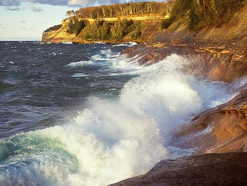
“Footprints”, Twelvemile Beach, Pictured Rocks National Lakeshore, photo by Michigan Nut

“I’d rather do 20 miles on soft sand than 10 miles on the side of the road. There is something about being where water meets land. I feel very clicked-in there. I feel like I can go forever.”
~Loreen Niewenhuis

USA Today has a feature on Loreen Niewenhuis, a Battle Creek resident who has hiked a good deal of the shorelines of all the Great Lakes. As to why, she explains:

“Our older son had gone off to college. The nest was emptying. I’d gotten my” master’s of fine arts degree … “but I felt I could stack up novels and not have an agent and be in my office writing novels forever,” says Niewenhuis, 49. “So I thought, let me do something completely different and get out of my office.”

So she put on her hiking boots. She got out the office.

Boy, did she ever.

Click through to read more about her journey and what she learned along the way. You can keep up with Lorraine’s latest including a planned walk on 1000 of Michigan islands on her Facebook page and at laketrek.com.

This photo is of Twelve Mile Beach in the Pictured Rocks National Lakeshore on Lake Superior, certainly one of the state’s best beaches. Check John’s photo out on black and see more in his My Favorites slideshow.

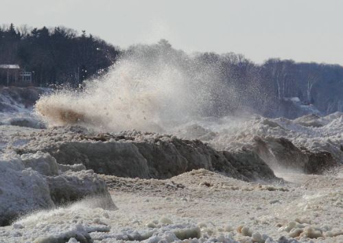
Lakes Michigan, Huron, Superior & Erie? Michigan in Pictures has them and all kinds of beach photos!

Algae Blooms threaten Lake Erie

like an oil slick

like an oil slick, photo by 1ManWithACamera

I’d like to offer an apology of sorts for this photo. It goes like this: “I’m really, really sorry that I sometimes have to blog photos of the ugly things that threaten what’s beautiful in Michigan. I wish I didn’t have such a good reason to!”

Michigan has only the tiniest sliver of Lake Erie shoreline, so little that we sometimes forget that it is one of the lakes that define our Great Lakes State. Lake Erie served once at the canary in the coal mine for pollution of the Great Lakes, and it may once again be sounding a warning call. A recent front page of the New York Times featured scary news about algae blooms on Lake Erie:

For those who live and play on the shores of Lake Erie, the spring rains that will begin falling here soon are less a blessing than a portent. They could threaten the very future of the lake itself.

Lake Erie is sick. A thick and growing coat of toxic algae appears each summer, so vast that in 2011 it covered a sixth of its waters, contributing to an expanding dead zone on its bottom, reducing fish populations, fouling beaches and crippling a tourism industry that generates more than $10 billion in revenue annually.

…Dead algae sink to the lake bed, where bacteria that decompose the algae consume most of the oxygen. In central Lake Erie, a dead zone now covers up to a third of the entire lake bottom in bad years.

“The fact that it’s bigger and longer in duration is a bad thing,” said Peter Richards, a senior research scientist at the National Center for Water Quality Research at Heidelberg University in Ohio. “Fish that like to live in cold bottom waters have to move up in the thermocline, where it’s too warm for them. They get eaten, and that tends to decrease the growth rates of a lot of the fish.”

Read on for a whole lot more including how farming practices are intersecting with invasive zebra mussels and climate change to magnify the dangers.

Larry’s photo is from Lake Huron and shows a different kind of algal bloom. I got some similar ones on Lake Michigan, and the folks at Michigan Sea Grant have a whole album of them.

See it on black, view happier shots in his Caseville & Port Austin slideshow and see more of Larry’s work on Michigan in Pictures.

More Lake Erie on Michigan in Pictures.

Ice Field

ice field

ice field, photo by northernlightphotograph

Check this out on black, see more from Tim on Michigan in Pictures and definitely check out his 2013 Winter Ice slideshow.

Low Point for the Great Lakes

Low water levels, West Arm Grand Traverse Bay

Low water levels, West Arm Grand Traverse Bay, photo by michiganseagrant

On Michigan in Pictures I usually blog beautiful things, but today I’m featuring an ugly thing that we in Michigan should all be concerned about. Traverse City based Circle of Blue has an in-depth feature on the record-low level of Lake Michigan-Huron:

The latest numbers released by the U.S. Army Corps of Engineers on February 5 show that both lakes Michigan and Huron — which are two connected lakes — are experiencing their lowest point since records began in 1918. Water levels were an average of 175.57 meters (576.02 feet) for the month of January, approximately 2.5 centimeters (1 inch) lower than the previous record set in 1964.

“Not only have water levels on Michigan-Huron broken records the past two months, but they have been very near record lows for the last several months before then,” said John Allis, chief of the Great Lakes Hydraulics and Hydrology Office at the Corps, in a press release. “Lake Michigan-Huron’s water levels have also been below average for the past 14 years, which is the longest period of sustained below-average levels since 1918 for that lake.”

The low water levels, which the Corps attributes to: below-average snowfall during the winter of 2011-2012, last summer’s drought, and above-average evaporation during the summer and fall of 2012, have the potential to hurt the Great Lakes’ shipping industry.

…For the water levels on Lake Michigan-Huron to reach even near-average water levels again, the Corps said it will take many seasons with above average precipitation and below-average evaporation.

Read on at Circle of Blue for much more including the struggles that wildlife are having with the changing climate. You can also view the release from the Army Corps of Engineers and see historic Great Lakes levels back to 1918. From the Army Corps, I learned that at 1 1/2 ft below normal, ships are losing 8-10% of their carrying capacity.

Beyond harm to the multi-billion dollar shipping industry which feeds countless industrial endeavors, the low lake levels are making many of our recreational harbors inaccessible. These feed our multi-billion dollar sport fishing industry and  this has prompted Gov. Snyder to endorse a $21 million emergency dredging plan, $11 million of which would come from Michigan’s general fund. With over a half a million jobs in Michigan alone tied to the health of the Great Lakes, getting a handle on the threats that impact them are likely to be at the center of our policy and spending for a long time.

In a curious bit of synchronicity, you can see just how vital the Great Lakes are to Michigan in Michigan Sea Grant’s reports on Economic Vitality and the Great Lakes. View this photo bigger and see more in their Grand Traverse Bay Low Water slideshow.

Lots more Lake Huron and Lake Michigan on Michigan in Pictures.

Ice Machine: How Shoreline Ice Forms on the Great Lakes

Lake Michigan Ice by Tim Wenzel

Snowball Fight Anyone?, photo by Timothy Wenzel

One of my favorite photo blogs is the Earth Science Picture of the Day from NASA. In Wednesday’s blog, Timothy wrote:

This photo, taken on January 24, 2013, illustrates how ice on Lake Michigan’s eastern shore can achieve heights of many feet; by accretion of floating snowball-size ice balls thrown upward by wave action. The maximum wave height (crest to trough) on Lake Michigan on this day was approximately 6 ft (2 m). What results is a landscape that looks almost volcanicClick here to see video of this phenomenon. Note that the lake itself is a slurry of ice and water.

Definitely check Tim’s video out! See the photo background bigtacular and see more in Timothy’s work including more photos from the day in his Weather Underground gallery.

More EPOD awesomeness on Michigan in Pictures!

Happy Holidays!

Happy Holidays!

Happy Holidays!, photo by Silver Cat Photography

Happy holidays to everyone. I hope that the days and year to come bring you all manner of happiness and health.

View this photo bigger and in Silver Cat Photography’s beach slideshow.

Lake Michigan

Lake Michigan

Lake Michigan, photo by karstenphoto

Check this out background bigtacular and see more in Steve’s Film! slideshow.

More black & white photography and more Lake Michigan from Michigan in Pictures.

Dogs vs Seagulls (and bacteria)

Untitled

Untitled, photo by jenny murray

The Great Lakes Echo has a feature on an Environmental Science & Technology journal report on how scientists have used dogs to rid a Lake Michigan beach of seagulls. Why do that you ask? While gulls are certainly part of the Great Lakes beach experience, seagull waste contains bacteria that harms water quality & sometimes closes beaches. The test took place in Racine, Wisconsin and they explain:

For eleven days researchers calculated the concentration of different bacteria on the Lake Michigan beach. They measured E.coli and Enterococcus concentrations to calculate fecal contamination. In addition, the study collected information on potentially pathogenic bacteria, which can cause infectious diseases.

Researchers then used two trained border collies with handlers to harass gulls while continuing to survey the water quality.

The dogs prompted the gull population to drop 98 percent, from nearly 670 birds to just fewer than 20.

Fewer gulls meant better water. E.coli bacteria decreased nearly 30 percent with the removal of half the gulls. Before the dogs started working, water samples tested positive for potentially infectious bacteria on seven out of eleven days. After the dogs chased the seagulls, researchers failed to find any contagious bacteria.

Read on for more about this innovative solution.

Check this photo of Dot out on black and see more in Jenny’s dot slideshow.

More beaches on Michigan in Pictures.

Channel Currents & Longshore Currents at Picnic Rocks

Storm Clouds over Picnic Rocks in Marquette, MI Labor Day 2012

Storm Clouds over Picnic Rocks in Marquette, MI Labor Day 2012, photo by Superior Seasons

Picnic Rocks is a popular beach area in Marquette. I thought that I’d come up with a good story for the name, but instead, I learned about the formation and dangers of what are known as channel & longshore currents. The Marquette National Weather Service explains:

A channel current is caused when water is squeezed between the shore and an offshore structure or feature (such as an island). When water is squeezed it speeds up, thus causing the current. This is like putting a smaller nozzle on a garden hose. When the smaller nozzle is on, the water comes out faster.

This current can be enhanced by what is known as a longshore current, a current that is generated by waves breaking onshore. As waves move onshore, they break in the direction they are moving in order to dissipate their energy. This causes the longshore current. Overtime, the current spans the entire width of the surf zone (the place where you swim). In the case of a channel current, the longshore current can speed up the channeling effect between the shore and the rocks, causing dangerous conditions to develop for those who are walking along the sandbar. The longshore current is maximized during times of higher waves that come in at a 45 degree angle to the shore.

…One could escape a channel current by swimming back to towards the shore. Many people make the mistake of swimming against the current as they are trying to get back to the sandbar. Think of the current as an underwater treadmill. In order to get off the treadmill, one needs to step off to the side of it. The channel current will be moving parallel to shore, so in order to escape, swim perpendicular to the shore.

Read on for more including a diagram demonstrating the best way to escape if you’re caught in these currents. A swimmer recently drowned here and this summer has been a deadly one – please use your knowledge to help others stay safe!

So we don’t end on a down note, let me say that in good weather, Picnic Rocks is a fantastic, natural playground for folks of all ages!!

Check this out background big and in Superior Season’s Marquette slideshow.

More from Marquette on Michigan in Pictures.

Hot Times for a Cold Lake

Lake Superior waves

Lake Superior waves, photo by ER Post

Hot times for a cold lake; Lake Superior headed for record temp from the Great Lakes Echo says that Lake Superior is already the warmest it’s been at this time of year in at least a century. The group Climate Central recently reported that Lake Superior began warming earlier than normal because of low lake ice cover, the March heat wave and warm temps have kept the heat on.

“It’s pretty safe to say that what we’re seeing here is the warmest that we’ve seen in Lake Superior in a century,” said Jay Austin, a professor at the University of Minnesota at Duluth, who has researched the lake’s water temperatures back to the beginning of the 20th century.

The lake’s record temperatures are yet another consequence of the record heat so far in 2012. The contiguous U.S. had its warmest January-to-June period since records began in the late 19th century. Manmade global warming will likely result in more years with very warm water temperatures, which could have significant adverse consequences for marine life. In a rare benefit from the ongoing drought, this summer has been so dry that the warm water temperatures are not resulting in major harmful algal blooms, such as one that occurred on Lake Erie last year.

Instrument data from three buoys in Lake Superior provide a reliable record of water temperatures since about 1980, and the information also shows that, with water temperatures running in the mid-to-upper 60s (and even warmer closer to shore), “we are at record temperatures for this time of year,” according to Austin.

When the 2nd biggest lake on the planet is sounding alarm bells, it might be a good idea to listen.

See this photo bigger and in Ed’s Michigan Scenery slideshow.