Philip’s Water Tower Project

philips-water-tower-project-caseville

Philip in Caseville, MI, photo by Philip’s Water Tower Project

Let’s just jump right in to Philip’s Water Tower Project:

Philip is a 5 year old Autistic boy from Michigan. He has recently developed a love of water towers. Upon a simple google search, he realized he couldn’t find many pictures of water towers in our area. So he made it his mission to “cheese” (take pictures) with as many water towers as he could. We are up to 21 cities so far in the thumb of Michigan.

After speaking with one of my friends who came up with the idea to have others send in pictures from all over the country of them with water towers, I spoke with Philip about the idea and he loved it. So this page was born. If you’d like to participate please message or post a picture of yourself (or your kiddos) with a water tower near you. Be sure to point at the water tower in the picture, it’s his signature move!

View more photos right here and definitely share a pic with Philip’s page if you’re near a water tower in Michigan or elsewhere!

Good Luck Aurora!

good-luck-aurora-borealis

Good Luck Aurora, photo by Lake Superior Photo

Shawn of Lake Superior Photo shared this and writes:

So.. it looks like aurora could be active through the weekend… good luck photo: one of the more memorable geomagnetic experiences from the south shore of Superior… a very animated proton arc from a little over a month ago

NOAA/NWS Space Weather Prediction Center confirms that a G1 warning is in effect tonight & tomorrow that brings the chance of northern lights sightings to Michigan and an even more potentially potent G2 warning is in effect for the 24th. Click for more about the scales and definitely consider subscribing for aurora alerts!!

Follow Lake Superior Photo on Facebook and view & purchase photos of northern lights (aurora panoramas too!) and more at LakeSuperiorPhoto.com!

More about northern lights including what a “proton arc” is on Michigan in Pictures!

Lake Charlevoix Fall Colors

lake-charlevoix-fall-colors-by-frank-wulfers

Lake Charlevoix Fall Colors, photo by frank wulfers

Frank took this shot on Wednesday from the Avalanche Mountain Scenic Overlook in Boyne City. As you can see, this will be the weekend for fall color across much of Michigan, so check out some great fall scenes on Michigan in Pictures and make your plans for a getaway!

View Frank’s photo bigger and see more in his Michigan – Northwest slideshow.

High Noon: 1909: Marquette Main Street via Shorpy

Marquette Front Street

Marquette Front Street c 1909, photo by Lycurgus S. Glover (Detroit Publishing Co)

The Shorpy Photo Archive is a magical website that has been around for years, dishing up incredible and well presented public domain photos from around the country. Many, like this one of Main Street in Marquette from 1909, are from Michigan. In addition to a link to purchase a print of the photo, all include a giant view of the image and a discussion board that uncovers many of the details that become apparent when you look at the picture closely such as this odd detail in the lower right:

“Why is there a wooden platform behind him leading to a blank wall?”

The wooden platform is actually a bridge over a set of railroad tracks that lead out to cranes for unloading coal in the Marquette Harbor. The wall is for safety as it was a 16′ drop down to the tracks. See attached links for different view of Front Street and the City of Marquette around that time. You can see the same wood bridge in one and the cranes in the other. Also you can see the ore docks that gravity load iron ore into ore boats to take the iron ore to Pittsburgh. Iron mining was and still is a big business in Marquette County. The photo in question was taken standing on the a steel bridge leading to the old ore dock that can be seen in the attached photos.

Click through to check the photo out background bigtacular. As one commenter notes, “It’s noon by the building clock, and the locals are mobbing the ice cream parlor.”

Moonglow at Tahquamenon Falls

moonglow-y-rudy-malmquist

Moonglow, photo by Rudy Malmquist

Gorgeous photo from after dark at Tahquamenon Falls State Park.

View Rudy’s photo background bigtacular and see more in his slideshow.

Lots more about Tahquamenon Falls on Michigan in Pictures.

Misty Bond Falls

misty-bond-falls-by-yanbing-shi

Misty Bond Falls, photo by Yanbing Shi

Gorgeous photo from Bond Falls in the western Upper Peninsula taken back in October of 2014. GoWaterfalling’s page on Bond Falls says (in part):

This is the best single waterfall in the Western U.P, and the second best waterfall in Michigan. If you are in the Western U.P., possibly on your way to or from the Porcupines or Copper Harbor, this is a definitely worth a stop.

…The main drop is 40 feet high and 100+ feet wide. Above the main falls are a series of cascades and rapids that must drop a total of 20 feet. The water level is controlled by a dam, and a steady flow over the falls is maintained for scenic reasons. Of course during the spring melt the flow is much higher.

View Yanbing Shi’s photo bigger and see more from Michigan and elsewhere in his Landscape slideshow.

More Michigan waterfalls and more fog & mist on Michigan in Pictures.

Tonight’s Hunter’s Moon … and November’s Extra Super Moon

hunters-moon-october

Catching the Hunter’s Moon, photo by Brad Worrell

EarthSky notes that 2016 Hunter’s Moon is also a supermoon, explaining:

In some months, the full moon is closer to us in orbit than others. The 2016 Hunter’s Moon does happen to be particularly close. It’s near perigee, the moon’s closest point to Earth in its monthly orbit. Perigee comes on October 16 at 23:36 UTC (translate to your time zone), about 19 hours after the crest of the moon’s full phase at 4:23 UTC on the same date. Nowadays, people call these close full moons supermoons.

Some don’t like the word supermoon … but we like it. Full moons at their closest to Earth do look brighter. They have a larger-than-usual effect on earthly tides. Although most of us can’t detect that a supermoon appears larger to the eye, very careful and experienced observers say it’s possible.

So you won’t likely see a bigger-than-usual moon (unless you see it near the horizon, an effect known as the moon illusion). But you can notice how brightly the moon is shining, especially on the nights of October 15 and 16!

Next month – in November 2016, the full moon and perigee (closest point) come even closer together to stage the largest full moon of the year on November 14. … That November 2016 full moon will feature the closest supermoon since 1948!

Tons more about the Hunter’s Moon on EarthSky!

View Brad’s photo bigger and seem more in his Not More Pictures of the Moon! slideshow (note: more pictures of the moon are there).

Friday Fall Color Update from the High Rollways


high-roll-away-buckley-michigan

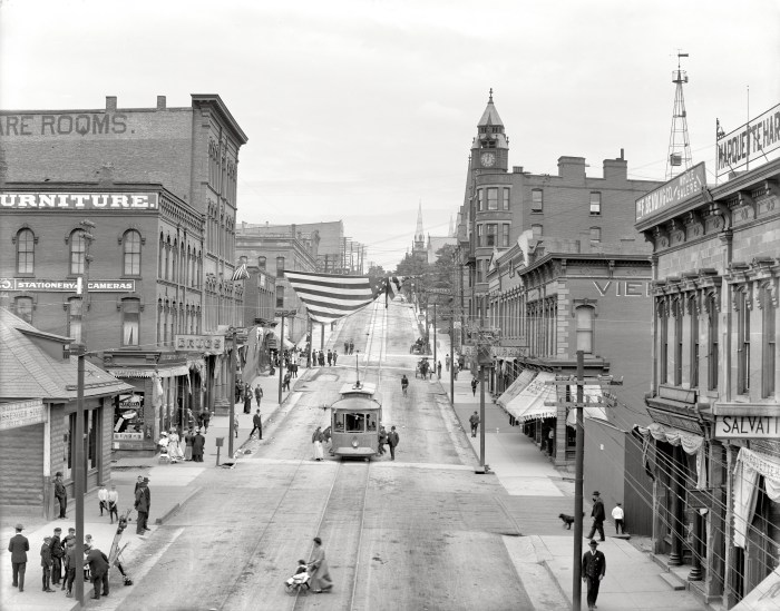
High Roll Away, photo by Charles Bonham

“Of all the places I’ve worked here in Michigan, this is my favorite place to collect my senses, do a little meditating and get rid of my problems. It’s like a soothing balm.”
-Ray Westbrook, retired DNR on the High Roll-Away

Charles took this yesterday at the Buckley High Roll-Away overlooking the Manistee River, and it shows how autumn color continues to lag a bit behind in northern lower Michigan. mLive posted some satellite pics of fall color from NASA’s Aqua satellite earlier this week that give you a look at how things are shaping up. If you’re thinking about a jaunt, Pure Michigan’s fall color tours provide some pre-planned ideas all over the state. To get current fall color, I usually find it best to pick your location and call their chamber or visitor’s bureau. The bigger ones in Traverse City, Petoskey, Marquette, Grand Rapids, and elsewhere will often have a good idea about a large range.

MyNorth’s Jeff Smith has a great story on Buckley’s Big View that says in part:

Like any notable landmark without an official name, this one goes by several aliases—Horseshoe Bend Overlook, Lookout Point or the Highbanks Overlook—not to mention spelling variations. Depends who you ask.

Stand atop the Roll-Away and the scenery is for certain. From the lookout it’s 200 feet down, and before you the valley curls up like a vast bowl, taking in a viewscape of almost 130 square miles of dense pine and hardwood forest. The bowl’s rim, a ridge, runs roughly from Manton in the east, around to Meauwataka and Harrietta in the south (you’ll see the distant radio towers), and on the west to Mesick.

Here, more than a century ago, the expanse of treetops inspired awe among those who saw wealth in the more than 1.2 billion board feet of lumber in the upper Manistee River basin. Surveying the area in 1869 for the Manistee River Improvement Company, A.S. Wordsworth wrote, “This river is the great highway that penetrates the vast pine region of Manistee. … It is without doubt the best logging stream in the world, and all along its circuitous path, reaching far away, it seems to bear mute testimony to the wonderful wisdom of the Creator.”

Read on for lots more and here’s the map on Waymarking!

You can get Charles’ photo background bigtacular and see more in his slideshow.

Lots more fall color and fall wallpaper on Michigan in Pictures!


Today’s the Day for the Michigan Apple Crunch!

grand-traverse-bay-apples

apples, photo by Diane Greene Lent

A Healthier Michigan is a pretty cool blog with some state-specific tips for better health. Their post on the annual  Michigan’s Apple Crunch Day (Thursday, October 13)  says that every October, schools, organizations, and businesses bite into Michigan apples on the same day, setting records for apples eaten.

It’s a partnership between the Michigan Department of Education, Michigan Farm to School, Cherry Capital Foods and Cultivate Michigan as a reminder of the importance of agriculture and knowing where your food comes from. Last year 400,000 people in Michigan ate a Michigan-grown apple on Apple Crunch Day!

The Michigan Apple Committee notes that with 11.3 million apple trees covering 35,500 acres on 825 family-run farms, Michigan is the nation’s third largest producer of apples!

View Diane’s photo of apples overlooking Grand Traverse Bay background big and see more in her Best 2012 slideshow.

Here’s a video with photos from last year’s Apple Crunch by Cherry Capital Foods!

Stoll Trail Incident and How Isle Royale Became a Park

Version 4

Silhouette of a Moose, photo by Nina

Nina writes that she came upon this moose looking like a fake silhouette against a beautiful backdrop while hiking Albert Stoll Memorial Trail just before sunset at Isle Royale. Read Houghton, Flight to Isle Royale, and the Stoll Trail Incident for lots more including photos on Nina’s blog Black Coffee at Sunrise.

This excellent history of Isle Royale National Park from ParkVision explains how this remote Lake Superior Island became a park and Mr. Stoll’s role:

As early as the 1860’s some visited the island for touring or pleasure. But by the turn of the century a real tourism industry was beginning to exist on the island, fueled in part by the growth of midwestern cities. The first hotel on the island, the Johns Hotel, was built in 1892, and other early resorts were built at Tobin Harbor, Rock Harbor, and Washington Island. By the 1920’s there were a number of sizeable resorts located on Isle Royale and some of the smaller islands surrounding it. The moist, cool air on the island provided a popular escape from the midwestern summer heat and for hay fever sufferers.

The 1920’s also brought an effort to gain preservation of and national park status for the island. This effort was spearheaded by Albert Stoll Jr. of the Detroit News, and it was endorsed by Stephen Mather who visited the island in 1924. The threat of extensive logging of the island’s forests in 1922 enhanced concern about the importance of preservation of the island’s magnificent natural resources. Isle Royale gained a measure of fame as a result of a daring winter visit by plane by Ben East and his companions.

In 1930 the Michigan legislature created the Isle Royale National Park Commission. Establishment of the island and surrounding areas as a national park was authorized when Herbert Hoover signed legislation on March 31, 1931. However, initially no money was authorized for its establishment. The Depression and World War II intervened, and it was not until August of 1946 after all park lands had been acquired that the park was finally dedicated in a ceremony on Mott Island.

Read on for lots more!

View Nina’s photo background big and see more at Black Coffee at Sunrise where she will have further posts from her latest journey!