Detroit is shining brightly

Detroit Shining Brightly by Chris Ahern Photography

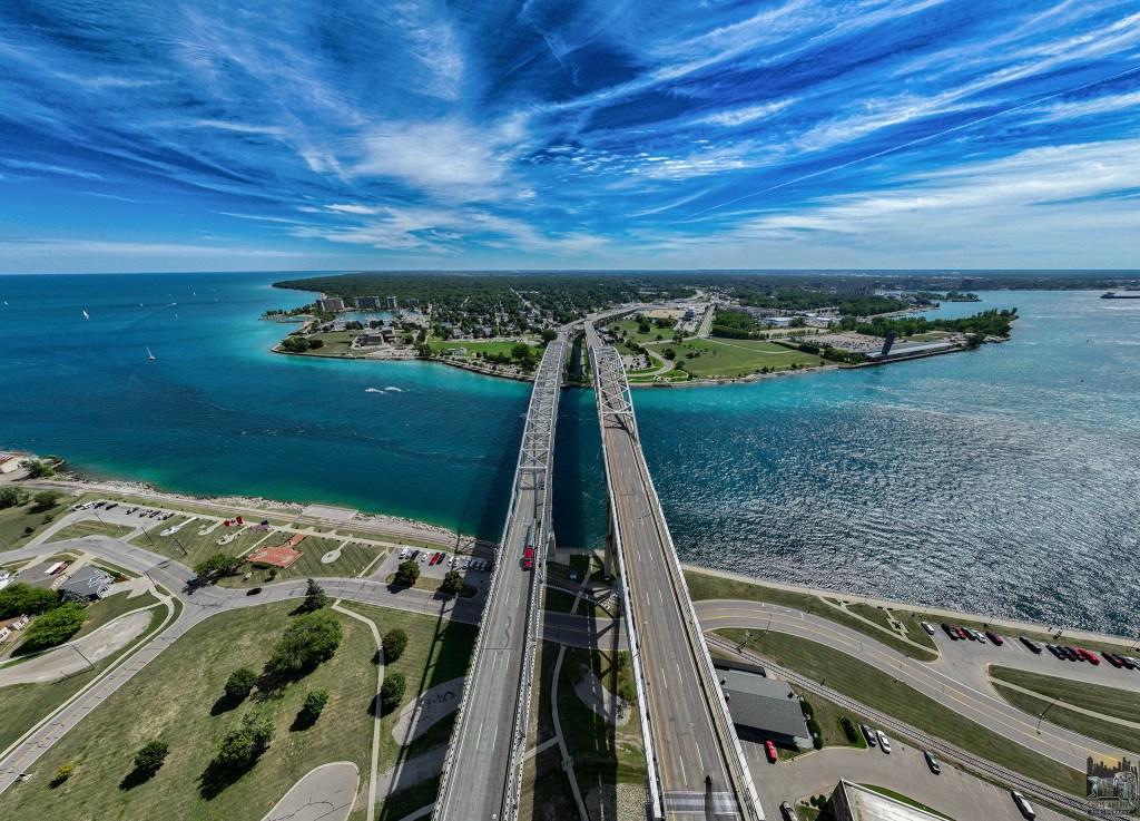
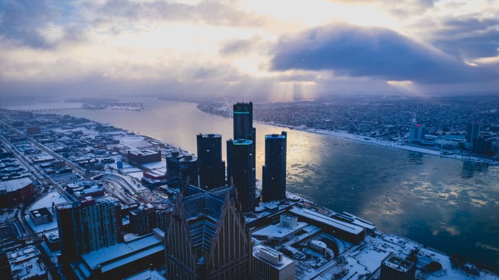
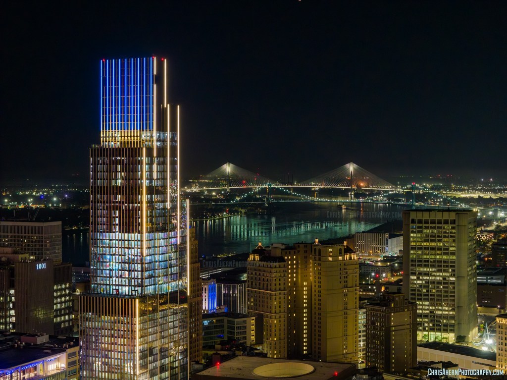
Hudson and Gordie Howe Bridge with new lighting by Chris Ahern Photography

Chris shared a perfect photo for a roundup of recent Detroit news saying: “Both projects broke ground in 2020. The Hudson’s site is now Detroit’s second tallest building, while the Gordie Howe Bridge is the longest cable-stayed bridge in North America. Also lit up is the Ambassador Bridge which recently reached its 100 year anniversary.” (the Ambassador is in the foreground with the string of lights).

For starters, the Gordie Howe International Bridge connecting Detroit to Windsor announced that the planned Fall 2025 opening has been delayed to 2026. WDIV Detroit writes:

While 98% of the $5.7 billion project is complete, bridge officials say the remaining work is forcing the delay from the previously announced fall 2025 openingThe final phase focuses heavily on testing the bridge’s technological systems.

A report from S&P Global Ratings indicated that contractors had missed previous deadlines for transferring border facilities to authorities, though bridge officials would not specifically comment on this.

Detroit has definitely been on the come up in recent years, but it is still notable that 13 years after a poll showed two-thirds of Detroiters felt the city was moving in the wrong direction, a new survey found a dramatic, 180-degree turnaround with 76% feeling the city is headed in the right direction with 11% disagreeing & 13% having no opinion. Among that 11% is Livonia resident & leader of the Detroit News editorial page Nolan Finley, who ruffled more than a few feathers when he suggested that Detroiters are deluded to express contentment.

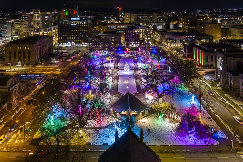
If you tuned in to Monday Night Football to see the Lions whomp on the Buccaneers, you saw the spectacular drone footage of Detroit taken by Chris. I can’t find it all, but you can see some drone video of the Hudson on his Instagram & also of the Detroit Riverfront on the opening of the Monday Night Football highlights. For sure follow Chris Ahern Photography on Facebook and view and purchase his work & drone photography services on his website!

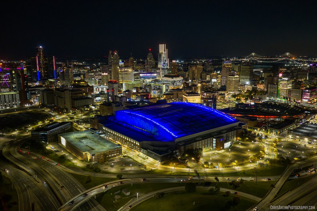
Ford Field from Above by Chris Ahern Photography

Support Michigan in Pictures with Patreon

Bright Lights, Small City

Above Kalamazoo's Bronson Park by William Dolak

Above Kalamazoo’s Bronson Park by William Dolak

I’ve been seeing photos from all across Michigan of communities lighting up for the holidays, and for my money Kalamazoo’s Bronson Park nailed it this year!

The man who nailed this drone shot, Bill Dolak, is one of the Michigan in Pictures Facebook group’s most active photographers, delivering great pics from in and around Kalamazoo, Michigan in good times like this and bad ones like this year’s devastating Kalamazoo/Portage Tornado.

You can click on either picture for a bunch more shots, and you should for sure check out all his posts in the Michigan in Pictures group!

Bronson Park Holiday Decorations by William Dolak

PS: The other day Bill shared a photo from above of snow covered, downed trees near Celery Flats Park in Portage.

Support Michigan in Pictures with Patreon

Bedrock & GM announce Renaissance Center Redesign

GlooM Headquarters by Camera Jesus

Yesterday Bedrock and General Motors announced a conceptual plan to redevelop the Renaissance Center (RenCen) and 27 acres along the Detroit riverfront. They say that the plan “preserves the essence of Detroit’s skyline, ‘right sizes’ the RenCen’s footprint, and connects the site to the heart of downtown. The surrounding entertainment district would become a vibrant waterfront destination, drawing international visitors and featuring restaurants, hospitality, residential and market space—complementing Detroit’s award-winning Riverwalk, which draws more than 3.5 million annual visitors to the city.”

Check out the renderings & Detroit News excerpt below for an idea of what’s in store & please share your thoughts. Personally, I’m glad that they’re preserving some of this truly iconic structure but honestly worried that it could end up being a terrifying albatross in the event of an economic downturn. Much more about the Renaissance Center on Michigan in Pictures.

It’s been a minute since I’ve featured a photo by the amazing Joe Gall aka Camera Jesus. He shared this back in January of 2023. Follow him on Facebook & Instagram for the latest and for sure head over to CameraJesus.com to view & purchase his photos including this beauty of a supermoon rising over the Ren Cen!!

Renaissance Center Conceptual Renderings by Bedrock

The Detroit News shares (in part):

The Renaissance Center would shrink to three towers with residential, office and hotel tenancy to create space for a six-acre riverfront park in a more than $1.6 billion redevelopment plan dependent on $250 million in state support that would make billionaire mortgage mogul Dan Gilbert’s real estate firm shared owner of the complex with current owner General Motors … Gilbert is contributing $1 billion in equity and debt, and GM is providing $250 million after having invested $1.5 billion into the building during its ownership. A new entity owning the site will reflect each party’s contribution toward the redevelopment, said Dave Massaron, GM’s vice president of infrastructure and corporate citizenship.

Support Michigan in Pictures with Patreon

Waugashaunce Point Trail in Wilderness State Park

Waugoshance Point by Jim Sorbie

Waugoshance Point by Jim Sorbie

I’m going to try to share more posts about great Michigan trails & hikes that are a little off the beaten path. If you have a favorite, share it in the comments! DWHIKES has the 411 on Waugashaunce Point Trail in Wilderness State Park north of Petoskey on Lake Michigan is a great trail that is DEFINITELY off the beaten path:

Waugoshance Point is easy to spot on a map, just look for the large peninsula jutting out from the northwestern corner of the lower peninsula: that’s it. If only for that reason it was an attractive place to want to take a hike. An added bonus was the fact that it marks the western end of the Mackinac Straits amidst three remote lighthouses and is completely devoid of trails. I simply couldn’t come up with a reason NOT to go.

Waugoshance Point is truly spectacular in the summer when the rock beaches are home to a myriad of waterfowl and a dizzying array of lake shore wildflowers. I just couldn’t wait though. The snow was gone and I needed to get out. The trail head, if there was a trail, is located at the end of Waugoshance Point Road which gives access to the back-country cabins of Wilderness State Park. From there I’d trust my topo-map to guide me along the shore out to the point. Though there are no hills or cliffs to speak of the area turned out to be quite diverse and beautiful, as you’ll see…

Here’s a great aerial photo by Jim – see more in his From the Air gallery on Flickr which also includes another view of the Point from August of 2022.

Shades of Blue .. Waugoshance Pt by Jim Sorbie

Shades of Blue .. Waugoshance Pt by Jim Sorbie

Support Michigan in Pictures with Patreon

Blue Water Bridge(s)

Blue Water Bridge(s) by Chris Ahern Photography

The Gordie Howe Bridge is (rightfully) getting a lot of attention these days, but another beautiful span connwcting Michigan with Canada is the Blue Water Bridge across the St. Clair River at the southern end of Lake Huron from Port Huron to Sarnia, Ontario. The Blue Water Bridge Authority shares:

The first bridge was opened to traffic on October 10, 1938. The lead engineer was Ralph Modjeski. This bridge originally had two lanes for vehicles as well as sidewalks; the latter were removed in the 1980s to make room for a third lane for automobiles. The third lane for each direction started from the apex of the bridge in order to accommodate long lineups entering each sides’ respective border crossings.

…In the early 1990s, bridge authorities decided to add a second arch in order to accommodate the high traffic. During the debate over the form of the second span, five possible designs were purposed from 1994-95. Over half of public opinion had mostly favored a duplicate of the first bridge, while the cable-stayed bridge came in second with around 21%. The Blue Water Bridge Authority had rejected both designs, due to the duplicate creating a false sense of history, while the cable-stayed option was feared to overshadow the existing bridge. Another cost-effective but unpopular design was the parallel truss. The continuous-tied arch design, which was a distant third place in polls, was chosen for two reasons. One was that it blends in with the original span yet stands out on its own, and the other is lower maintenance costs because fewer spans are involved.

Chris Ahern is a professional photographer & licensed commercial drone pilot who works in and around Detroit. Follow him on Facebook or Instagram & for sure check out his website.

Support Michigan in Pictures with Patreon

Golden Rays over Canada

Golden Rays over Canada by Craig Hensley

Golden Rays over Canada by Craig Hensley

Craig got this supersweet drone shot of downtown Detroit last week. In his photo you can see Belle Isle, the sun shining on Canada across the Detroit River at the left, the Renaissance Center towers in the center, and the art deco Guardian Building in the foreground. 

See more great shots in Craig’s Detroit gallery & view and purchase his work on his website.

Support Michigan in Pictures with Patreon

The Mouth of the Grand River

Mouth of the Grand River by Dan Gaken

Mouth of the Grand River by Dan Gaken

Cool shot of the Grand Haven Lighthouse at the mouth of the 252-mile long Grand River. See more shots from above in Dan’s Drone Photography gallery on Flickr.

Support Michigan in Pictures with Patreon

South Fox Island Light Station

South Fox Island Light Station by Dusty Klifman / Blueyes Below

South Fox Island Light Station by Dusty Klifman / Blueyes Below

My company recently completed a new website for the Fox Island Lighthouse Association. Their website explains:

The South Fox Light Station is located 22 miles offshore in NW Lake Michigan, south of Beaver Island and north of the Manitous. The 115 acres of MI state-owned land has much to offer, with seven original structures still standing and acres of pristine dune and wildlife; it is one of the most unique stations on Lake Michigan. The original tower was lit in 1867; the fog signal and oil house were built in 1895. The Workshop and Boat House were built in 1897. In 1934, the 68’ steel skeletal tower was brought from Sapelo Island, GA and reassembled on the island (automated in 1958). The two-story Assistant Keepers Quarters was added in 1910. The station was decommissioned in 1969.

In 1971, the State of Michigan bought the station from the Department of the Interior with a promise to provide recreational opportunity and access to the public.

You can head over to their website for information & photos about the station, its structures, and how you can help them with their work.

Diver/photographer Dusty Klifman of Blueyes Below, provided some photos for the website & the cool drone footage. Check him out for lots more photos & videos of shipwrecks & other maritime subjects.

Support Michigan in Pictures with Patreon

High above the St. Joseph River

St Joseph River by Bill Dolak

St Joseph River by Bill Dolak

Encyclopedia Britannica says that the 210-mile-long Saint Joseph River rises near Hillsdale in south-central Michigan, flowing generally west with a swing south into northern Indiana through Elkhart and South Bend before reentering Michigan to empty into Lake Michigan at Saint Joseph and Benton Harbor. Check out places to access the St. Joseph on Michigan Water Trails.

Bill took this photo of the St Joseph River near the Langley Covered Bridge with his drone a couple of weeks ago. See more of the river & the bridge in his Michigan: St. Joseph County gallery on Flickr!

Support Michigan in Pictures with Patreon

Looking Over Charlevoix

Charlevoix Michigan by Laurent Fady

Charlevoix, Michigan by Laurent Fady

Visit Charlevoix says that the Charlevoix area was part of what was called Michilimackinac formed in the Treaty of Washington in 1836:

French explorer Pierre François Xavier de Charlevoix is said to have stayed on nearby Fisherman Island and the area was named after him in 1836.

…Exclusive hotels, the Inn and the Beach, were the summer destination for people from around the Midwest. Two depots served summer guests, one at Belvedere and the Pere Marquette Railway depot. Guests also arrived in the late 1800s on steamships including the Manitou, Alabama, North American, South American, Milwaukee Clipper, and Illinois.

During the Prohibition, Chicago area gang members moved their operations to Charlevoix. The Colonial Club became a gambling joint for some of the Midwest’s most powerful. A barge-turned-speakeasy traveled from Charlevoix to Boyne City carrying passengers in style during the summer months.

Lots more at Visit Charlevoix. Laurent took this sweet aerial photo of Charlevoix back in June. See many more views from above in his Aerial Photos of Northern MI gallery!

More Michigan aerial photos & more from Charlevoix on Michigan in Pictures.

Support Michigan in Pictures with Patreon