Birds Eye View of the Huron Mountains

Birds Eye View of the Huron Mountains

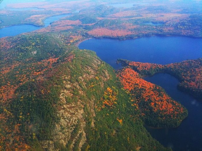
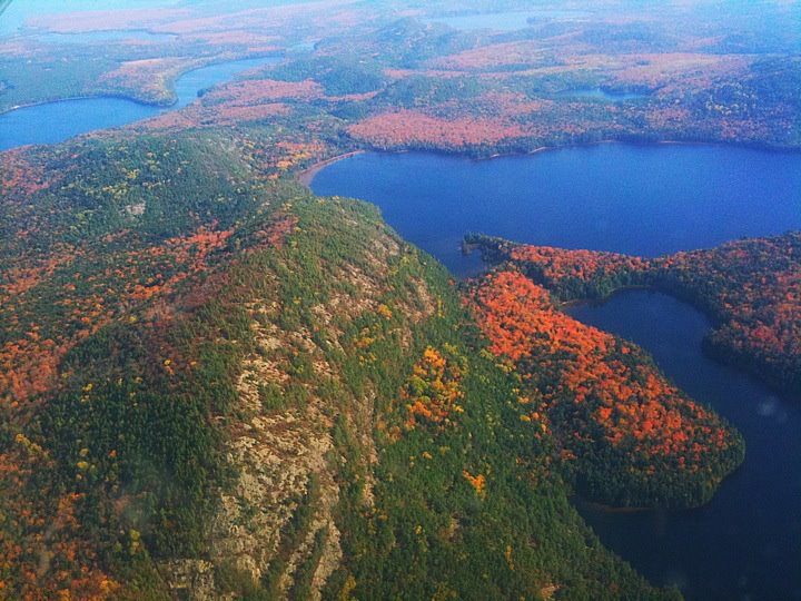
Birds Eye View of the Huron Mountains, photo by Kristian Saile

Summit Post’s page on the Huron Mountains says:

The Huron Mountains encompass THE most wild and rugged territory in Michigan. It is a region of low, yet surprisingly rugged mountains, swamps, lakes, and high plateaus. It is because this is such a large and diverse region that I decided to devote a page to the entire range in addition to the two prominent peaks already on this site (Arvon & Hogback). The majority of peaks in this area are unnamed and for the most part inaccessible. I have spent many years living near them, spent countless hours and days exploring them and feel like I’ve barely scratched the surface. The region has become increasingly popular with climbers in the past few years for its numerous granite cliffs. You’ll need a local to find them though:)

The Huron Mountains are the largest range of mountains in Michigan yet they are not listed on any map. The boundaries of the range are vague but generally include the area north of US-41 between Marquette and L’anse. This is approx. a 1000 sq. mi. chunk of real estate without a single paved road.

The Hurons can be divided up into three ranges. The Arvon Range includes the highest peaks, Mount Arvon (1980′) and Curwood (1979′), in the state of Michigan. The Arvon Range runs generally north-south in eastern Baraga County. The most rugged section, The Huron Range, runs northwest-southeast to the west of Big Bay in northern Marquette County. The highest peak in this region is Ives Hill at approx. 1400 feet. This part of the mountains has the most rugged relief, the highest waterfalls, and the prettiest lakes. Unfortunately a good chunk of it privately owned by the uber-exclusive Huron Mountain Club and is off-limits to the general public. The third region is the most accessible, the Marquette Iron Range. This region runs from Lake Superior at Marquette west to the Lake Michigamme area. Hogback Mountain (1200′), listed separately, is part of this range but numerous unnamed peaks to the west rise to over 1700 feet.

Read on for more and also check out the post author’s Michigan hikes – a lot of cool ones!

My friend Kristian took this in early October of 2011 while flying with his buddy Jon over the Huron Mountains. Click to view it bigger (if you can’t see it on facebook, try this link).

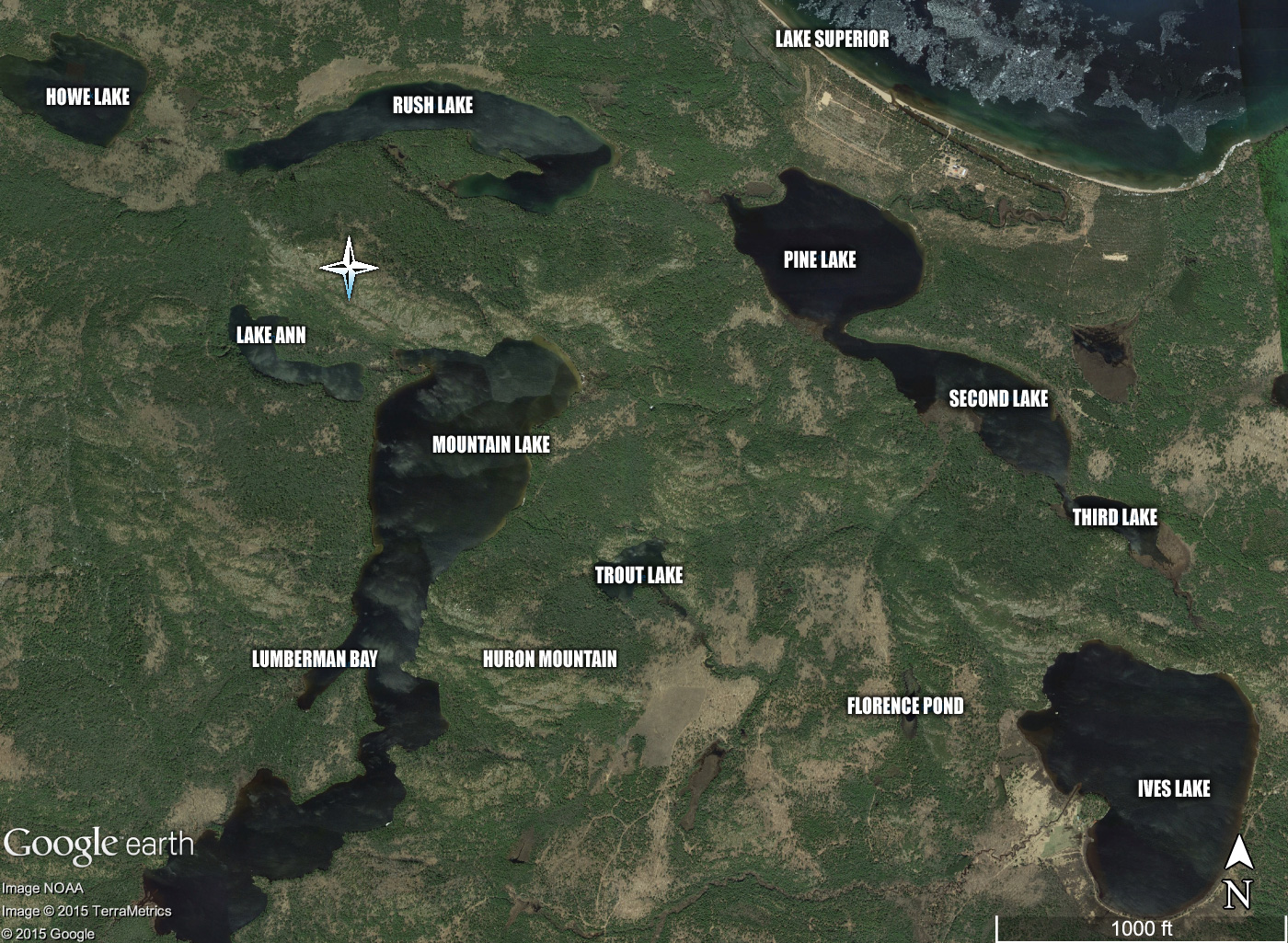
Another friend, Dick Huey of upwaterfront.com, researched the location for me – click the pic below to see it bigger.

The-Huron-Mts.-in-the-Huron-Mt.-Club

More aerial photos on Michigan in Pictures.

Fall reflections at Black River Harbor

Fall Reflections at Black River

Fall reflections at Black River Harbor, photo by Michigan Nut Photography

The Ottawa National Forest page on Black River Harbor Recreation Area explains:

Known for its spectacular waterfalls, idyllic beaches, scenic hiking trails and tranquil campground, the Black River Harbor Recreation Area is a popular destination throughout the year. Originating in Wisconsin, the Black River flows through forested areas of large pine, hemlock and hardwood trees. The River has a series of scenic waterfalls as it drops in elevation to meet Lake Superior. Tannin (tannic acids) from hemlock trees is what gives it its unique color.

The Harbor offers one of the area’s few access points to Lake Superior, with boating being a major summer time activity. The boat ramp can accommodate almost any craft trailered in. There is no launching fee. Boat fuel and snacks are available through the concessionaire. Parking for trucks and boat trailers is ample.

Read on more more information including a map.

John took this photo a few days ago. Check it out bigger and definitely follow Michigan Nut Photography on Facebook for more great fall color and lots more of Michigan at its best!

Mission Hill, Spectacle Lake & Fall Color 2015

Mission Hill View Upper Peninsula Michigan

Mission Hill 3, photo by Susan H

Here’s a look-in on the current state of fall color in the northeastern Upper Peninsula. DWHIKE has this to say about the Mission Hill trail, which also affords views of Spectacle Lake & Monocle Lake:

Monocle Lake sits just inland from Lake Superior about a half hours’ drive west of Sault Ste. Marie. Along its south shore is a nice National Forest campground which serves as the trailhead for the days adventure. The Monocle Lake Trail heads east from the swimming area at the south end of the lake for little more than a quarter mile where it splits north and south in to the North Country Trail and the Mission Hill Trail respectively…

Directions to Trailhead: -Take Highway 221 north from M-28 west of Sault Ste. Marie. -Follow Hwy 221 for 2.5 miles, through Brimley, to Lakeshore Drive. -Turn left on Lakeshore Drive, follow it 5 miles to Tower Road on the left. -Follow Tower Road (which changes to dirt as you climb the hill) 1.5 miles to overlook and trailhead on the right.

Click above for a map where you can need both lakes and get more about the Monocle Lake Trail from the DNR.

Susan took this photo on Sunday. View it big as the sky and see more in her UP slideshow.

Lots more Fall wallpaper on Michigan in Pictures!

Otter Creek Aurora

Otter Creek Aurora

Otter Creek Aurora, photo by Snap Happy Gal Photography

This is one shot from an incredible video that Heather made of the northern lights as seen from Esch Road Beach in the Sleeping Bear Dunes National Lakeshore. That’s Otter Creek in the foreground.

Click to view bigger, follow Snap Happy Gal on Facebook, and definitely watch that video – meteors!!

Lots more northern lights on Michigan in Pictures.

Golden Mushroom

Mushroom by Kevin Povenz

Mushroom, photo by Kevin Povenz

Kevin says that Google suggests this mushroom is amanita flavoconia, putting it squarely in the “look but probably better not eat” category.

View it bigger and see more in Kevin’s Flowers/Plants slideshow.

More mushrooms on Michigan in Pictures.

#TBT: Comet Biela and the Great Michigan Fire of 1871

House fire

House fire, photo by Ogedn

“The proponents of the cometary explanation cite many fascinating details confirmed by eye witness reports: the descent of fire from the heavens, a great ‘tornado’ of fire rushing across the landscape and tearing buildings from their foundations, descending balls of fire, a rain of red dust, great explosions of wind accompanied by blasts of thunder, buildings exploding into flame where no fire was burning, and a good deal more.”
~thunderbolts.info

We all probably know of Mrs. O’Leary’s cow and the Chicago Fire that burned over three miles of the city to the ground, but perhaps you’d care to take “Fires beginning October 8, 1871” for $500? Four fires began 144 years ago on this day in 1871: the Great Chicago Fire, the Great Michigan Fire, the Peshtigo (Wisconsin) Fire and the Port Huron Fire.

I’m going to let the crew of thunderbolts take it away with an excerpt from their fascinating feature The Comet and the Chicago Fire:

Contrary to popular folklore, the Chicago fire is not the worst in U.S. history. It was not even the worst to occur on October 8 that year. The same evening—in fact, at the same time, about 9:30—a fierce wildfire struck in Peshtigo, Wisconsin, over 200 miles to the north of Chicago, destroying the town and a dozen other villages. Estimates of those killed range upward from 1200 to 2500 in a single night. It was not the Chicago fire but the simultaneous “Peshtigo Fire” that was the deadliest in U.S. history.

And there is more. On the same evening, across Lake Michigan, another fire also wreaked havoc. Though smaller fires had been burning for some time—not unusual under the reported conditions—the most intense outburst appears to have erupted simultaneously with the Chicago and Peshtigo fires. The blaze is said to have then burned for over a month, consuming over 2,000,000 acres and killing at least 200.

Concerning the Michigan outburst, it is reported that numerous fires endangered towns across the state. The city of Holland was destroyed by fire and in Lansing flames threatened the agricultural college. In Thumb, farmers fled an inferno that some newspapers dubbed, “The Fiery Fiend.” Reports say that fires threatened Muskegon, South Haven, Grand Rapids, Wayland, reaching the outskirts of Big Rapids. A steamship passing the Manitou Islands reported they were on fire.

There can be no doubt that weather conditions at the time favored wildfires. But never before, and never since, has the U.S. seen such wildly destructive simultaneous conflagrations. This “coincidence”, combined with many unusual phenomena reported by eyewitnesses, has led some to conclude that an extraordinary force, one not of the earth, was a more likely “arson” than either a misbehaving cow or a regional drought.

In 1883, Ignatius Donnelly, author of Ragnarok: the Rain of Fire and Gravel, suggested that in early historic times our Earth suffered great catastrophes from cometary intruders. To this claim he added: “There is reason to believe that the present generation has passed through the gaseous prolongation of a comet’s tail, and that hundreds of human beings lost their lives”. He was referring to the conflagration of 1871.

Definitely read on for much more about the possibility of a comet’s tail, perhaps Comet Biela, fueling the fires.

Ogedn took this photo of a controlled burn by the local fire department, who practiced on this house before letting it burn. View the photo background big and see this and lots more in their slideshow.

Tons more Michigan history on Michigan in Pictures.

PS: I definitely did more research on this than I should have on this, and while the cometary theory and Comet Biela was observed to be broken apart on its pass in 1846, it may be that Biela’s Comet returned in September of 1872. In any case check the article out and also their Picture of the Day for a lot more than you’ve probably thought about.

Waterfall Wednesday: Catching Fire at O Kun de Kun Falls

O Kun de Kun Falls falls on the Baltimore River

O Kun de Kun Falls, photo by Tom Mortenson

GoWaterfalling’s page on the O Kun de Kun Falls says in part:

O Kun de Kun Falls is one of the largest of the waterfalls in Ontanagon county. It is not as large as Bond Falls or Agate Falls, but it is just as scenic and far wilder. It is a mile plus hike to O Kun de Kun Falls and there are no fences or signs. The waterfall is also unusual in that it is an actual plunge falls. Only a handful of the many waterfalls around Lake Superior are plunge falls. You can go behind the falls if you want, but you need to be careful and sure footed.

Read on for more including directions. You can also check out the Ottawa National Forest page on O Kun de Kun Falls for a satellite map of the area.

If you’re wondering about the name of the falls, it was after a famous chief, Kun de Kun meaning “To Keep Up the Net” from the Leach Lake band of Ottawa. Here’s a picture of him!

Last Tuesday Tom took us to Bond Falls, and he returns this morning with a shot from O Kun de Kun showing that fall color is finally kicking off! View it background big and view lots more of his waterfall photos on Flickr.

More fall wallpaper and more waterfalls on Michigan in Pictures.

Best in the Nation: M-22 Fall Color Touring

M22 Color Tour

Color Tour … south M-22, photo by Ken Scott Photography

While the leaves have yet to turn for serious in northwest lower Michigan, Michigan picked up yet another national accolade. The readers of USA TODAY​ voted for the best fall scenic drive and their #1 pick was Michigan’s M-22:

The M-22 route along Lake Michigan is one of America’s most beautiful tours, and it gets even better in the fall. This 116-mile road brings visitors through the peaceful countryside and along the shore, past small businesses, wineries, galleries and, of course, countless colorful trees. Visitors can stop and visit points of interest along the way and meet some locals, making this fall leaves trip a little bit wildlife and a little bit small town, all in one.

As a person who’s lived on or near M-22 for much of my life, I heartily agree! Read on to see the other selections, learn more about the 116-mile Michigan Highway 22, and visit this website for more about M-22 Fall Color Touring.

View Ken’s photo bigger, check out lots more of his pics of M-22 in every season and definitely follow him on Facebook!

Lots more fall color on Michigan in Pictures!

Michigan in Petoskey stones in the Final 20 for ArtPrize 7

michigan petoskey stone

michigan petoskey stone, photo by Jacob Vanderheyden

The ArtPrize Seven Final 20 has been announced with 3 of the top entries from 2013 once again in the running. Click the link to see them all, incuding this one: michigan petoskey stone by Randall Libby from Manistee. It’s on display at the DeVos Center – here’s the scoop:

WORLDS LARGEST PETOSKEY STONE DISPLAY Using petoskey stone and fossil, a framed two-dimensional display with a square shape that measures approximately nine feet (9ft.) tall by nine feet (9ft.) wide / a depth of approximately 4 inches and a weight near 700lbs. Subject matter- State of Michigan map with all 83 counties. One of a kind Hundreds of hours of labor with hundreds of individual slices of semi-precious stone- this item is sure to compete for top placement in art prize. To see examples of earlier work go to petoskeystoneart.com

View Jacob’s photo background bigtacular and see lots more in his ArtPrize 2015 slideshow.

More of ArtPrize through the years on Michigan in Pictures.

Under An Autumn Sunbeam: Fall Color Explained

Fall Color 2015 in Michigan

Under An Autumn Sunbeam, photo by Owen Weber

As we wait for the fall color season in Michigan to kick off, here’s a look back to last October and my annual rework of one of the most popular posts on Michigan in Pictures, the Science of Fall Color. If you already know the words you can sing along – have a great weekend folks!

The Science of Color in Autumn Leaves from the United States National Arboretum says (in part):

Many think that cool weather or frost cause the leaves to change color. While temperature may dictate the color and its intensity, it is only one of many environmental factors that play a part in painting deciduous woodlands in glorious fall colors.

…The process that starts the cascade of events that result in fall color is actually a growth process. In late summer or early autumn, the days begin to get shorter, and nights are longer. Like most plants, deciduous trees and shrubs are rather sensitive to length of the dark period each day. When nights reach a threshold value and are long enough, the cells near the juncture of the leaf and the stem divide rapidly, but they do not expand. This abscission layer is a corky layer of cells that slowly begins to block transport of materials such as carbohydrates from the leaf to the branch. It also blocks the flow of minerals from the roots into the leaves. Because the starting time of the whole process is dependent on night length, fall colors appear at about the same time each year in a given location, whether temperatures are cooler or warmer than normal.

During the growing season, chlorophyll is replaced constantly in the leaves. Chlorophyll breaks down with exposure to light in the same way that colored paper fades in sunlight. The leaves must manufacture new chlorophyll to replace chlorophyll that is lost in this way. In autumn, when the connection between the leaf and the rest of the plant begins to be blocked off, the production of chlorophyll slows and then stops. In a relatively short time period, the chlorophyll disappears completely.

This is when autumn colors are revealed. Chlorophyll normally masks the yellow pigments known as xanthophylls and the orange pigments called carotenoids — both then become visible when the green chlorophyll is gone. These colors are present in the leaf throughout the growing season. Red and purple pigments come from anthocyanins. In the fall anthocyanins are manufactured from the sugars that are trapped in the leaf. In most plants anthocyanins are typically not present during the growing season.

As autumn progresses, the cells in the abscission layer become more dry and corky. The connections between cells become weakened, and the leaves break off with time. Many trees and shrubs lose their leaves when they are still very colorful. Some plants retain a great deal of their foliage through much of the winter, but the leaves do not retain their color for long. Like chlorophyll, the other pigments eventually break down in light or when they are frozen. The only pigments that remain are tannins, which are brown.

Temperature, sunlight, and soil moisture greatly influence the quality of the fall foliage display. Abundant sunlight and low temperatures after the time the abscission layer forms cause the chlorophyll to be destroyed more rapidly. Cool temperatures, particularly at night, combined with abundant sunlight, promote the formation of more anthocyanins. Freezing conditions destroy the machinery responsible for manufacturing anthocyanins, so early frost means an early end to colorful foliage. Drought stress during the growing season can sometimes trigger the early formation of the abscission layer, and leaves may drop before they have a chance to develop fall coloration. A growing season with ample moisture that is followed by a rather dry, cool, sunny autumn that is marked by warm days and cool but frostless nights provides the best weather conditions for development of the brightest fall colors. Lack of wind and rain in the autumn prolongs the display; wind or heavy rain may cause the leaves to be lost before they develop their full color potential.

OK, sorry to share a novel with you. Might have to change the name of the blog to “Michigan in a Whole Bunch of Words with a Picture.”

Owen took this last October in Glen Arbor. View it bigger and see more in his Michigan slideshow.

PS: I have to think that it doesn’t look the same there this year due to the crazy storm they are still recovering from.

Tons more fall photos on Michigan in Pictures.