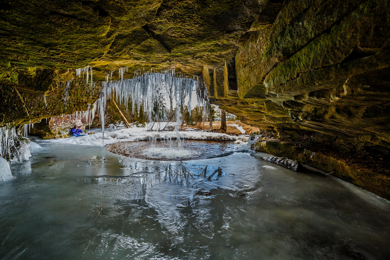
Every time I think I know every waterfall in Michigan, one more comes a long. Great Lakes Waterfall Adventures shares that Little Union Gorge Falls is:
Located inside an outpost campground off of South Boundary Rd. in the beautiful Porcupine Mountains State Park, the Union Gorge Falls slide shallow water over a 100 plus foot drop in a forested setting. It is a short hike to reach the start of the falls, and the trail follows the river bank for a quarter mile, intersecting several times with the Union Mine Interpretive Trail. Several sections of 10-25 feet highlight the area, thin water most of the year, most likely the best time to visit is in the spring.
…The first long drop has a small, three foot deep pool below it, adding to the calm of the area.
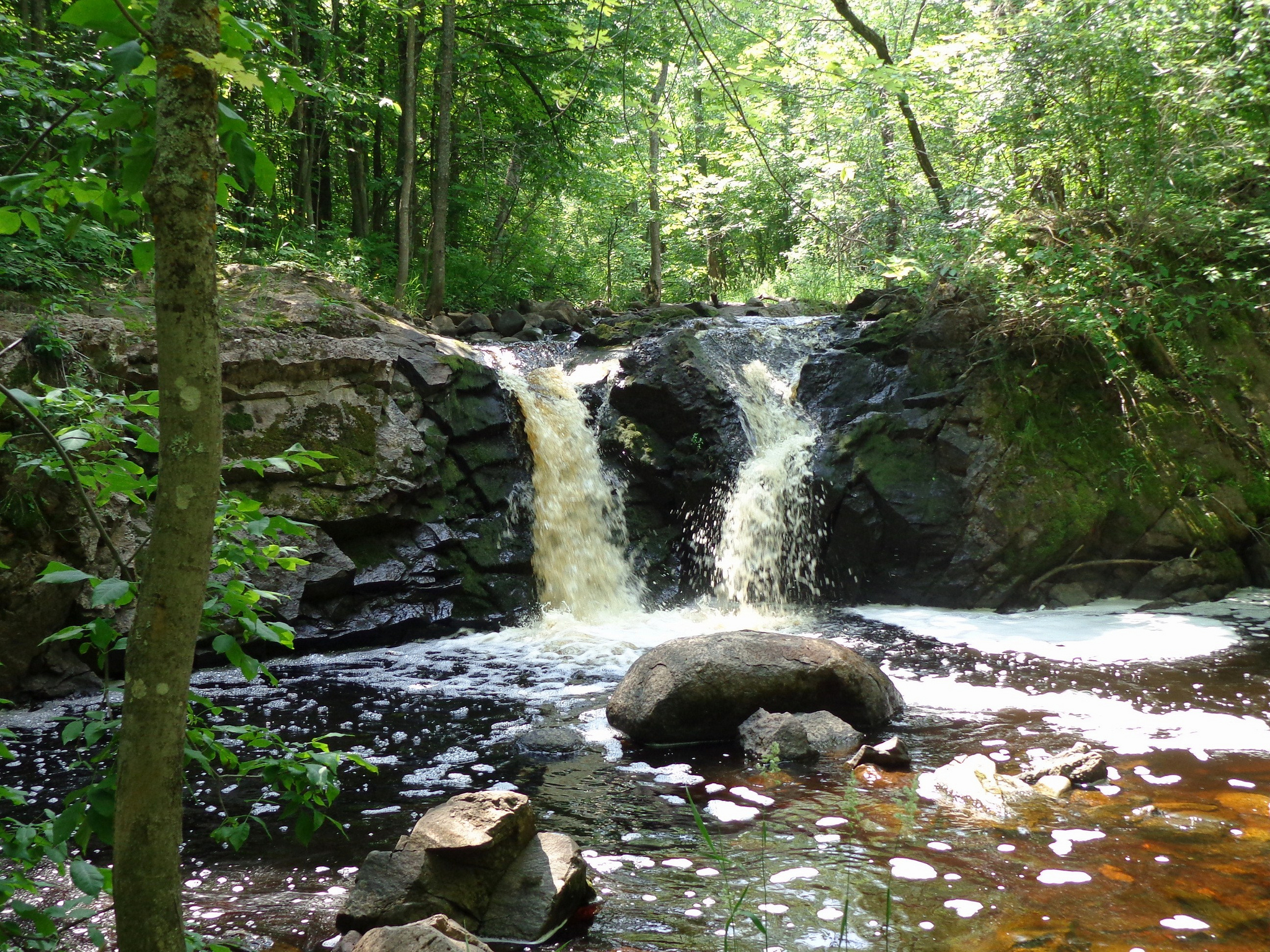
Big Eric’s Falls is located on the Huron River east of Skanee. The falls consists of a series of drops, each of which are only a few feet high, but around 100 feet wide. It is named for Big Eric Erickson, a logger from the 20’s. In addition to the falls, he also has a road, a bridge and a campground named for him (although sometimes the name is spelled ‘Erick’, so maybe they were named for his father?). Big Eric’s Bridge Campground is right next to the falls. The falls are just below the bridge.
To reach the falls head east on Skanee Road until it ends. This is also the end of the pavement. Head right on Erick road for a mile until you reach the bridge. Beyond the bridge are rough, unpaved road, and some wild waterfalls such as Forty Foot Falls. Big Falls, a much larger drop on the Huron River, is several miles upstream.
Dover Creek tumbles overs a series of falls on its way down to Torch Lake. Two of the falls are around 20 feet high, and the last is a 50 foot drop, which is spectacular when the water is flowing. Unfortunately these falls are often nearly dry in the summer.
There are three falls 15 feet or higher on a half mile stretch of Dover Creek, plus a couple of smaller drops. In the spring time, or after some good rains, these waterfalls are very impressive. Unfortunately the creek has a very small watershed, and the falls are often reduced to trickles.
The three main drops are usually referred to as the upper, middle and lower falls. The upper falls is around 20 feet high. The water spills over an irreguarly shaped cliff into a small gorge.
Downstream of the upper falls is a dam and artificial lake. Below the dam are a couple of smaller drops, and the middle falls. The middle falls is also about 20 feet high, and is perhaps the most scenic in lower water. The cliff face here is smoother, and the water is not segmented the way it is at the upper falls. The middle falls is also the easiest to reach and there are plenty of good viewing spots.
Scott Falls is one of the easiest waterfalls to access in the Upper Peninsula. It is just east of the Au Train river and right on highway M28. Just across the highway is a roadside park complete with vaulted toilets, water, charcoal grills, picnic tables, and beach access. Scott Falls couldn’t’ be in a more convenient location.
I believe that many of us in the Upper Peninsula have found childhood memories of Scott Falls. Personally, I remember those warm summer days when my mother would take us for a swim at the roadside park. Of course we would be covered in sand from walking up the beach afterward, so mom would take us across the road and make us rinse off in Scott Falls. We would play in the water and have an adventure in the cave behind the falls. As a kid, sitting in that cave when the train comes through is amazing! I’m sure that many of us have shared similar experiences.
Click through for more! Regarding the photo, Mike writes:
This is how I prefer to see my world. A magical place, begging to be explored and enjoyed. I’m so lucky to have a partner that not only lets me, but comes along and enjoys it as I do.
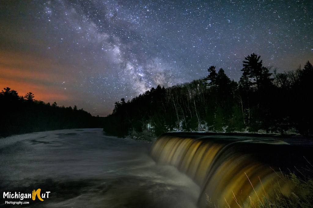
Julie got this cool shot of the Tahquamenon Falls throwing off winter’s grip at the beginning of the month. Now it looks like winter is going to strike back. Via the Detroit news and Sara Schultz, meteorologist with the National Weather Service in White Lake, a winter storm is arriving today:
“We’re looking at the heaviest snowfall north of Saginaw, in the Thumb area and then to the north and west of that, and then of course the lower northern Michigan areas, where they could see six-plus inches of snow.”
A winter storm watch will be in effect Wednesday morning through early Thursday evening for areas north of Interstate 69, Schultz said.
“We’re looking at areas south of I-69 as mostly rain,” she said. “Between Flint and Saginaw, we’re looking at accumulation of snow and ice; just some light accumulation.”
Schultz cautioned that the forecast remains flexible as the storm enters the state. “That rain/snow line along I-69, if it shifts just a little it could throw off everything,” she said.
When I come across a waterfall photo that I can’t place, I have three places I turn:
GoWaterfalling.com – hands down the best resource for waterfalls of Michigan and the Great Lakes region (with a few others scattered in for good effect). The author delivers concise descriptions, photos of the falls and accurate directions with maps and tips for hundreds of waterfalls.
Waterfalls of the Keweenaw – this site was created by Jacob Emerick and has information, directions and beautiful photos for 200 Michigan waterfalls, in the Keweenaw and beyond. Sorry for getting Jacob’s name wrong!!
I have my ideas as to which waterfall this is – any guesses? Post them in the comments!
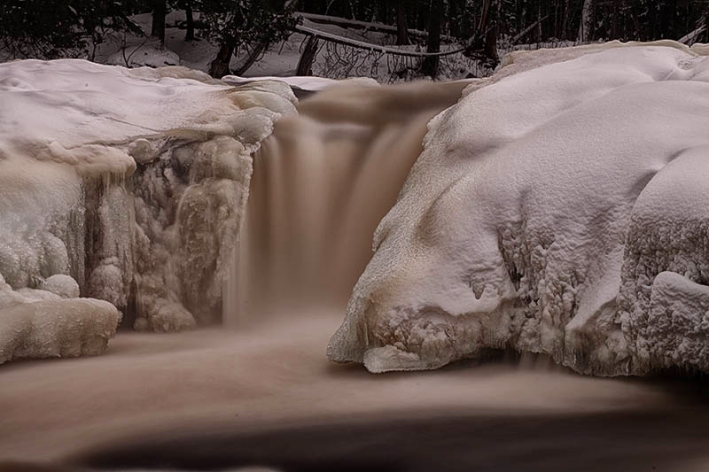
Paula took this last April on the Keweenaw when spring snowmelt in the U.P. pumps the waterfalls up to incredible levels. View her photo background big and see more including some crazy ice-climbing shots in her slideshow.
One of the coolest things for me about making Michigan in Pictures is when I come across something in Michigan that there’s little to no information about online.
Such is the case with Root Beer Falls (map), a roughly 8′ waterfall that is located a couple of miles north of Wakefield in Gogebic County. “Rootbeer Falls” is also a name for the Tahquamenon Falls, and one would assume that the same tannins that give Tahquamenon their rich, brown color are at work here.
Douglas Feltman posted this sweet time-lapse video from Root Beer Falls last fall, saying that this small drop on Planter Creek is fed by overflow from Sunday Lake in Wakefield, just a quick walk through the woods from Wertanen Road. He has 49 more Michigan waterfall videos as well!
The photographer, David Hedquist, is the author of Waterfalling in Wisconsin and has told me he’s working on a Michigan book, so stay tuned! Sorry- I misremembered. David is NOT working on a new book. He did share that Phil Stagg of Waterfalls of Michiganis writing books though!
Tahquamenon Falls State Park encompasses close to 50,000 acres stretching over 13 miles. Most of this is undeveloped woodland without roads, buildings or power lines. The centerpiece of the park, and the very reason for its existence, is the Tahquamenon River with its waterfalls. The Upper Falls is one the largest waterfalls east of the Mississippi. It has a drop of nearly 50 feet and is more than 200 feet across. A maximum flow of more than 50,000 gallons of water per second has been recorded cascading over these falls.
…This is the land of Longfellow’s Hiawatha – “by the rushing Tahquamenaw” Hiawatha built his canoe. Long before the white man set eyes on the river, the abundance of fish in its waters and animals along its shores attracted the Ojibwa Indians, who camped, farmed, fished and trapped along its banks. In the late 1800’s came the lumber barons and the river carried their logs by the millions to the mills. Lumberjacks, who harvested the tall timber, were among the first permanent white settlers in the area.
Rising from springs north of McMillan, the Tahquamenon River drains the watershed of an area of more than 790 square miles. From its source, it meanders 94 miles before emptying into Whitefish Bay. The amber color of the water is caused by tannins leached from the Cedar, Spruce and Hemlock in the swamps drained by the river. The extremely soft water churned by the action of the falls causes the large amounts of foam, which has been the trademark of the Tahquamenon since the days of the voyager.
The Waterfall Record’s page on Manido Falls has directions and some more photos and says:
Manido Falls did not impress me at first, at least not as much as the downstream Manabezho Falls. After seeing the pictures I had taken, though, I discovered what an amazingly beautiful waterfall Manido Falls is. It’s beauty comes from its complexity. The waterfall itself is not very tall at all. It is wide, though. As the Presque Isle River tumbles down toward Lake Superior, it comes to this set of rocks that create a beautifully cascading waterfall. I think what makes me like Manido Falls so much is that the water has taken such an interesting course here, erosion taking its effect in an oddly unique way.
Add to it that the just as spectacular Manabezho Falls is only hundreds of yards away, and Lake Superior not much more distant, this makes for one of the most beautiful waterfall stretches in the Upper Peninsula.
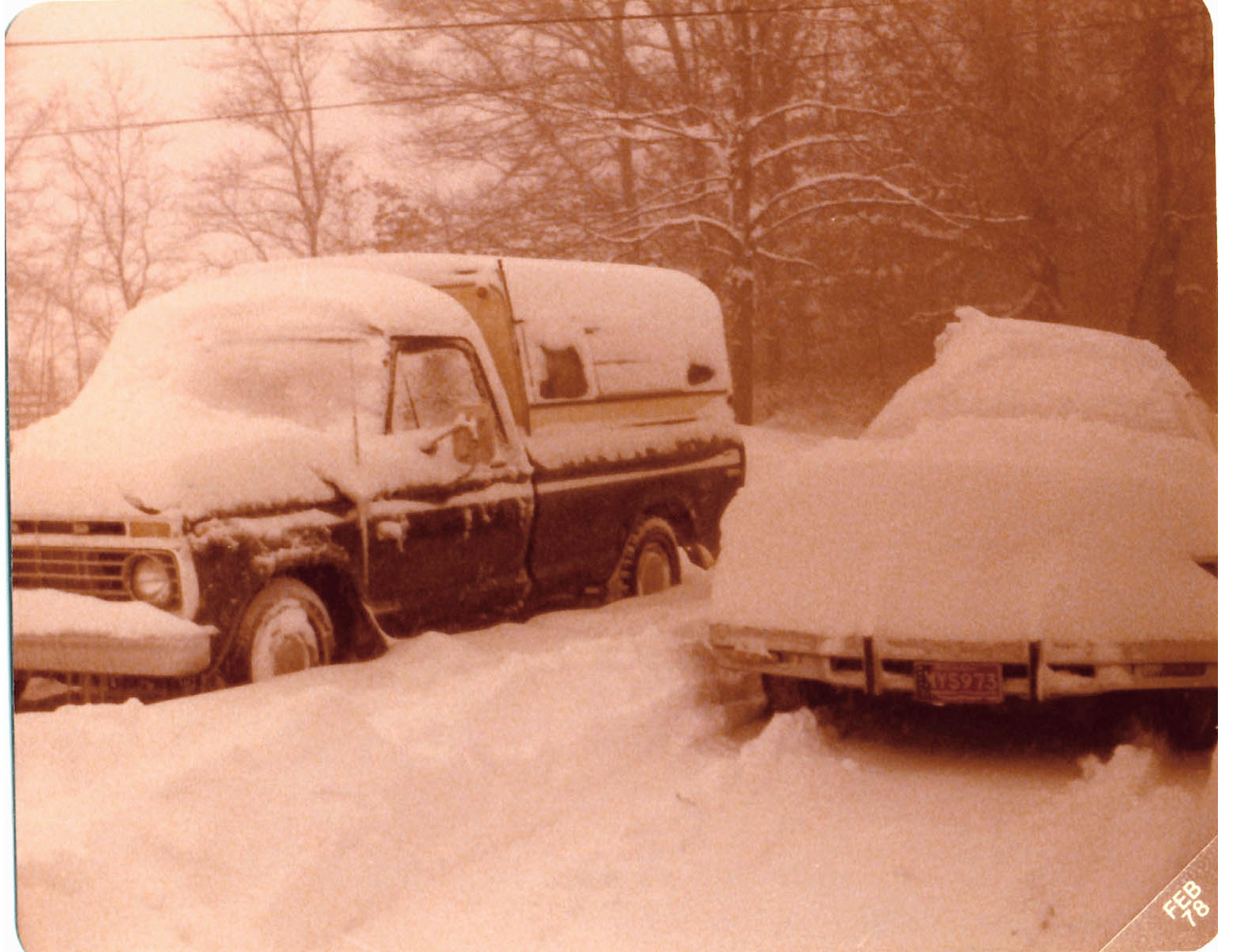
The most extensive and very nearly the most severe blizzard in Michigan history raged January 26, 1978 and into part of Friday January 27. About 20 people died as a direct or indirect result of the storm, most due to heart attacks or traffic accidents. At least one person died of exposure in a stranded automobile. Many were hospitalized for exposure, mostly from homes that lost power and heat. About 100,000 cars were abandoned on Michigan highways, most of them in the southeast part of the state. ~C. R. Snider, National Weather Service Meteorologist in Ann Arbor, Michigan
Today is Michigan’s 179th birthday, but it’s also the anniversary of one of the most significant storms to ever hit the state, the Great Blizzard of 1978. William Deedler’s article A Great Storm is Upon Michigan says in part:
While there are several contenders for the worst blizzard ever to hit the Great Lakes in relatively modern times (since 1870 when records began in Detroit), the immense and intense Blizzard of January 26-27th 1978 must rank at or near the top along with the Great White Hurricane of 1913(my link) with its similar track and powerfulness.
…As the Arctic air circulated throughout the storm while it made its way over Lake Huron, the lowest pressure was reached around 950 millibars or a hurricane-like 28.05 inches! “A Great Storm is Upon Michigan” read the headline of the 800 AM EST Special Weather Statement issued by the National Weather Service Forecast Office in Ann Arbor that Thursday /26th/ morning. Heavy snow and blizzard conditions were extensive as wind gusts in excess of 35 mph whipped the snow into huge drifts across much of Southeast Lower Michigan. Other areas of Eastern Michigan, Indiana and Ohio reported near hurricane-force winds, heavy snow and temperatures hovering between zero and 10 above, resulting in extreme blizzard conditions. These conditions later expanded further east into Pennsylvania and West Virginia and prevailed into the night (26-27th) across much of the Eastern Great Lakes, Southern Ontario and the Upper Ohio Valley. With the storm generating copious amounts of snow and very strong winds, whiteout conditions were widespread. All land and air traffic came to a stand still in the affected regions. Several major roads were closed for at least two to three days, if not longer, while clean up got underway. Numerous NWS employees were stranded at work, home, or on the road somewhere between the two. Several employees worked double shifts into at least Friday (some longer) because of the impassable roads with others simply unable to get to work.
The Blizzard Warnings were allowed to die across Michigan during the forenoon hours of Friday, the 27th. Record 24 hour snowfall totals from the storm included, 16.1 inches at Grand Rapids, 15.4 inches at Houghton Lake and 12.2 at Dayton, OH. Snowfalls for the entire storm (25-27th) included a whopping 30.0 inches at Muskegon (some of which was Lake Michigan enhanced), 19.3 inches at Lansing and 19.2 at Grand Rapids. Snowfalls were less over Southeast Lower Michigan (mainly because of the rain that fell for a period) and included 9.9 inches at Flint and 8.2 inches at Detroit.