Tahquamenon Falls

Tahquamenon Falls

Tahquamenon Falls, photo by A. Runyon.

Well, about a month ago I blogged this photo of the Mackinac Bridge.

Apparently, Amanda found this on the other side. She has another equally amazing photo right here, and you can read more about the Tahquamenon Falls on Michigan in Pictures.

I have to add that it’s a beautiful thing when someone makes a photo like this available in “background size”. ;)

Surfing, Michigan Style

Surfing01.jpg

Surfing01.jpg, photo by Evography.

Evography writes: Dropping in from the pier, the tricky part is not getting worked right back into the pier.

Check out his Great Lakes Surfing set (slideshow!!) for a bunch more photos, most of which are large enough for your computer background needs!

When you’re finished with that, head over to Absolute Michigan for a Michigan surfing extravaganza featuring tons of Great Lakes surfing videos (including some 1970s footage of folks surfing off this same pier!)

Which I should add is the Grand Haven Pier!

Waterfall Hunting in the Upper Peninsula

Ripley Falls

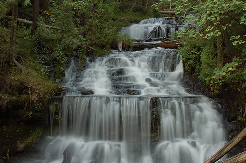
Ripley Falls, photo by We Are CS.

It’s probably fitting that I came to today’s post in a roundabout fashion. I was checking out UPLiving.com, a new addition to Absolute Michigan. On their photo page I saw this gorgeous photo of Ripley Falls. A quick check of The Google found a page on the Hiawatha National Forest site that itself seemed lost from their waterfalls page titled
115 Waterfalls of Michigan’s U.P.:

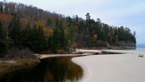
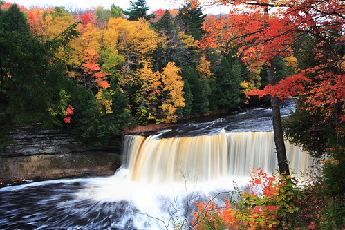
It’s been said there are two things man never tires of watching – fire and falling water. Hence the fascination of fireplaces and waterfalls. Fireplaces, fortunately, are found everywhere in the land. But waterfalls are found only in very special parts of the land. One of these is Michigan’s Upper Peninsula. There are more than 150 waterfalls across the length and breadth of this rugged peninsula – enough to satisfy any collector of cascades. Some are tall and stately like the Laughing Whitefish. Some are broad and massive like the mighty Tahquamenon. All are spectacles of white splendor … A few of the Upper Peninsula’s falls are located conveniently along well-traveled highways. More often the falls are the dramatic climax to a rewarding hike through the woods and in every case they are well worth the effort involved in getting there. Some waterfalls are located on private property permission should be secured from the owner to cross the property. When large land holders such as paper, utility, mining, and forest companies are involved, the public is usually welcome to use the forest lands, unless posted against entry.

Ripley Falls was listed as #42 with just the terse note Ripley Falls, on Ripley Creek behind school of Ripley. Springtime flow only.. The Keweenaw Local Resource Guide has better directions, but still not much to say.

Then I stumbled onto Wayne Premo’s Waterfalls from Hunt’s Guide to Michigan’s Upper Peninsula. Wayne tells the tale of how he lost the Michigamme Falls and then says:

As an adult I started to explore the Upper Peninsula further. The state’s Department of Natural Resources county maps became my guide. All the squiggles marking falls became increasingly intriguing. Would any of these be as impressive as Michigamme Falls, the one I had lost? I charted my plan of attack.

My goal was to search out every squiggle and photograph it, so that then I would have seen every waterfall of consequence in the Upper Peninsula. At the time, I was in no hurry and the task did not appear formidable.

Michigan WaterfallsSo go to Hunt’s Guide and read Wayne’s tale and check out some of the waterfalls he has photographed. Then think about bagging a few waterfalls this year. You can click the photo to the right to go on a Flickr tour of Michigan waterfalls.

And after all this, what does Wayne say about Ripley Falls? Only that it’s one of the few falls not on the DNR maps.

Fitting.

104

104

104, photo by Cara Jo Miller.

Cara Jo explains that this is a double exposure of the same negative – done in the dark room.

She is a photography & web design at Northern Michigan University. You can see a lot more of her work on Flickr and at her web site, cara-jo.net.

The Eben Ice Caves

Columns of Ice, Eben Ice Cave

Columns of Ice, Eben Ice Cave, photo by John Clement Howe.

This photo is one of a nice set titled At the Ice Cave of Eben taken in March of 2007 (or view slideshow of the Eben Ice Caves). A document from a field trip led by Dr. John Anderton of the Northern Michigan University Department of Geography explains:

The Eben Ices Caves are located just a few miles north of the little town of Eben, within the Rock River Canyon Wilderness Area (RRCW). The RRCW, which became a Wilderness in 1987 as a part of the Michigan Wilderness Act, is located approximately 15 miles west of the town of Munising, MI, within the Munising Ranger District of the Hiawatha National Forest. It comprises 4,460 acres and contains outstanding natural features including Rock River, Silver Creek and Ginpole Lake. Within its interior there are two short user-developed trails (totaling about 1.75 miles) leading to Rock River Falls and the Eben Ice Caves. An estimated 1,700 people visit the area annually (USFS records) …

The Ice Caves are not true caves at all. They consist of walls or vertical sheets of ice that form across the face of overhanging rock outcrops. In the summer, small unimpressive waterfalls and groundwater seeps may found along the overhangs. In the winter, however, the water hits the cold air, drips downward under the influence of gravity and freezes, creating spectacular ice caves. Each winter they look a little different, but typically there are openings in the ice that allow you to walk behind the ice walls.

The rock overhangs, where the ice caves form, consist of outcrops of Munising Formation (Cambrian) with a capstone of AuTrain Formation (Ordovician). The outcrops are found along the south side of the valley of Silver Creek, which is part of a network of secondary glacial drainage channels that formed during the Marquette Advance (about 10,000 years ago). Theses secondary drainage channels flowed easterly into the AuTrain-Whitefish Channel, a primary glacial meltwater channel that flowed south to the Lake Michigan basin. Groundwater naturally seeps from these rocks, providing the water necessary to form the ice caves in the winter.

For directions and more info, check out Rock River Falls & Rock River Canyon Wilderness Area (Hunts’ UP Guide) and Visit The Eben Ice Caves (Marquette Country CVB).

The Salmon Trout River on the Yellow Dog Plains

The Salmon Trout River on the Yellow Dog Plains

The Salmon Trout River on the Yellow Dog Plains, photo by savethewildup.

Somewhere there are lines, and I’m pretty sure that today I will cross a few. Over the life of this blog, I have stayed away from things that have sides, because sides too often divide us and this blog is really all about loving Michigan.

In my day job, I build web sites. A short while ago, I and some really talented people put together a new site for some people that have spent the last few years at a hard and lonely task: speaking up and standing up for Michigan’s rivers and lakes against the terrible risks posed by metallic sulfide mining and acid mine drainage.

They have been focused on the Salmon Trout River on the Yellow Dog Plains, but that is just the first of many that will follow. To be very clear: There has never been a metallic sulfide mine that has failed to pollute its watershed. You can read more from Save the Wild UP … and scroll down for a special treat featuring tons more photos and music from Greg Brown’s upcoming CD, Yellow Dog.

More photos of the beauty of the Yellow Dog Plains and Salmon Trout River can be seen at Save the Wild UP’s web site.

If you are a photographer who loves Michigan’s water and wild, please consider making them available to be used in fighting metallic sulfide mining and other threats to Michigan’s legacy of unspoiled water and add them to the Save the Wild UP photo pool.

Greg Brown, Yellow Dog slide show (or new window)

Peninsular Paper Co.

Peninsular Paper Co.

Peninsular Paper Co., photo by argusmaniac.

On the Huron River in Ypsilanti.

runs through it

runs through it

runs through it, photo by amy_kilroy.

This photo of the Miners River at Miners Beach where it empties into Lake Superior is one of a gorgeous set of photos of Pictured Rocks National Lakeshore by Amy Kilroy.

Yeah, it makes pretty good wallpaper too and is part of the Michigan in Pictures Michigan Fall Wallpaper series!

Upper Tahquamenon Falls in the Fall

Upper Tahquamenon Falls

Upper Tahquamenon Falls, photo by lluusz.

This photo was taken on October 16, 2005. I don’t speak Chinese, but I’m guessing this “上塔库梅珑瀑布” says something about what a glorious sight this is.

Wagner Falls

Wagner Falls 2

Wagner Falls 2, photo by gkretovic.

Wagner Falls is located south of Munising. The Michigan DNR page on Wagner Falls has directions and says that the falls are in a stand of virgin pine and hemlock. Click the pic below for Greg Kretovic’s Nature Set with more photos of Wagner Falls and other UP beauty.