Greensky Hill … and Greensky Bluegrass

Greensky Hill Indian Mission Church

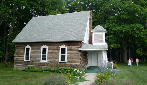
Greensky Hill Indian Mission Church, photo by jhhymas

Today’s post is in the “Stories I Found When Exploring Other Stories” category. Over on Absolute Michigan today we’re giving away two pairs of tickets to the October Festival at the Commons this Friday night in Traverse City. Greensky Bluegrass is a great band that tours nationally but hails from Michigan, and if you’re interested in seeing them and enjoying this festival in my backyard, click here to check it out & enter to win.

The Michigan Historical Marker text for Greensky Hill Mission via michmarkers.com reads:

Here in the 1840’s the Chippewa Indian missionary, Peter Greensky, established a Protestant mission in an area where legend says Indian chiefs once held their councils. New trees have been planted in an arrangement similar to that of the trees that made up the original council circle. Mission services first were held in a rude building of boughs and bark. In the 1850’s the Indians built the present church. It is a fine example of the old log style construction with hand-hewn timbers and notched corners. Windows, doors, and much of the lumber were brought by canoe from Traverse City to Pine Lake (now Lake Charlevoix) and then carried two miles to this site. Methodist services for the Indian congregation have been held here regularly to the present.

The Greensky Hill Indian Mission United Methodist Church adds that Peter Greensky started his preaching in the Leelanau area in the 1830s, serving as a guide and interpreter for his missionary Peter Doherty before acquiring a following of his own as a strong preacher with great influence among his people. His congregation traveled with him to the Charlevoix area. In 1860 he was put in charge of the all-Indian Pine River Mission, now known as Greensky Hill where he served there until his death in 1866.

June adds that her son-in-law’s mother was Ovenia Greensky Shomin, a direct descendant of the founder of this church. Check this out background big and see lots more photos of the mission and grounds (including details of the logs) in her Greensky Hill slideshow.

More Michigan churches on Michigan in Pictures.

Waterfall Wednesday: A Fall Morning at Bond Falls

Morning fog

Morning fog, photo by adonyvan

Bond Falls is is one of Michigan’s most beautiful waterfalls and a frequent guest on this blog. Click for more Bond Falls photos from Michigan in Pictures including a great one from a month ago of Bond Falls under the stars by the same photographer!

Check this out on black and see much more in Jiqing Fan’s Houghton & UP MI slideshow.

There’s more Michigan waterfalls and more Michigan sunrises on Michigan in Pictures.

Fall is a great time to be nuts for Michigan

“The Rushing Tahquamenaw”   Tahquamenon Falls, Upper Michigan (explore # 258 Oct. 9, 2010)

The Rushing Tahquamenaw” Tahquamenon Falls, Upper Michigan, photo by Michigan Nut

Last week the Lansing State Journal asked Michigan in Pictures regular John McCormick aka Michigan Nut Photography about his favorite Michigan color touring destinations. His list is features five fantastic fall locations: Porcupine Mountains, Pictured Rocks National Lakeshore, the Cadillac area, Sleeping Bear Dunes National Lakeshore and the Tahquamenon Falls.

It’s a great list and John is a tremendous landscape photographer. About this photo John writes:

The Brown color of the water in the Tahquamenon River comes from tannins leached from the dense Cedar-Hemlock-Spruce swamps in the river’s headwaters. The river’s total watershed encompasses more than 790 square miles. The Tahquamenon River flows into Lake Superior, after winding nearly 100 miles through Michigan’s Upper Peninsula to empty into Whitefish Bay.

This is the land of Longfellow’s Hiawatha (“by the rushing Tahquamenaw” Hiawatha built his canoe). The Objibwa Indians lived in this rich land of fish, fur, and big game. In the late 1800’s, much of the region was logged off, with the Tahq River being one of the main tranportation routes to drive logs to the sawmills. Today, the falls are protected by this wonderful Michigan State Park for all to enjoy.

See his work at Michigan Nut Photography or dive in to his spectacular Autumn in Michigan slideshow.

Lots more about Tahquamenon Falls on Michigan in Pictures.

Gabbro Falls and the Black River Scenic Byway

From Above - Gabbro Falls (Black River - Upper Michigan)

From Above – Gabbro Falls (Black River – Upper Michigan), photo by Aaron C. Jors

Gabbro Falls is one of several very nice waterfalls on the Black River. Others are Great Conglomerate Falls, Gorge Falls, Potawatomi Falls, Sandstone Falls and Rainbow Falls – click that link for more info from GoWaterfalling.com.

The Black River Scenic Byway:

…is in the western corner of Michigan’s Upper Peninsula, near the Wisconsin state line. The byway begins in Bessemer and travels north to the road’s end on the shores of Lake Superior. Black River is 15 miles long and follows North Moore Street, Saint Johns Road, and Black River Road (CR 513). All are two-lane paved roads suitable for all types of vehicles. The byway is open year-round.

The Black River scenic byway crosses the Ottawa National Forest alongside the meandering Black River through areas of old growth hemlock and hardwoods of the Black River Valley. The byway offers scenic views of the distant Porcupine Mountains. In autumn, the byway is bathed in colors of red, orange, and gold.

Aaron’s photo from early October of 2010 certainly bears that out. See it on black and view more in his awesome Waterfalls slideshow.

More waterfalls on Michigan in Pictures.

What’s in a Name? Tahquamenon Falls edition

Tahquamenon Falls

Tahquamenon Falls, photo by AndrewH324

We’ll close out Waterfall Week on Michigan in Pictures with this photo that has been the cover photo on the Absolute Michigan Facebook all week. Here’s hoping that you get a chance to enjoy one of Michigan’s nearly 200 waterfalls soon!

With a drop of nearly 50 feet, a width of over 200 feet and a maximum flow of more than 50,000 gallons of water, the Upper Tahquamenon Falls are one of the largest waterfalls east of the Mississippi. Pronounced about how it looks – like “phenomenon,” the falls gained fame way back in 1856 in Henry Wadsworth Longfellow’s Song of Hiawatha:

Lay aside your cloak, O Birch-tree! lay aside your white-skin wrapper,
For the Summer-time is coming, and the sun is warm in heaven,
And you need no white-skin wrapper!” thus aloud cried Hiawatha
In the solitary forest, by the rushing Taquamenaw

A feature back in 2006 from the Chicago Tribune offers one popular theory for the name:

The river and its two falls (the smaller Lower Falls are further downstream) are located in the northeast part of Michigan’s Upper Peninsula, just miles from Lake Superior, in the 46,000-acre Tahquamenon Falls State Park. The Upper Falls is one of the largest waterfalls this side of the Mississippi in the United States. (Niagara–shared with Canada–is the largest.)The park is dense with both hardwoods and pine and filled with wildlife. Sightings of moose, gray wolves, black bears, American martens and river otters are typical, and have always been an attraction for nature lovers–including Henry Wadsworth Longfellow, whose poem about this area recounts how Hiawatha built his canoe “by the rushing Tahquamenaw.” The spelling was a variation of Tahquamenon, which comes from an Ojibwa word meaning “dark berry.”

Origins of the Name from the Michigan DNR suggests an alternative root of the name:

The word Tahquamenon has not been as easy to trace. There have been many theories to the origins of this name, such as the color of the water of the Tahquamenon River or meaning the place of the blueberry swamps.

In his book, “Lake Superior Place Names: From Bawating to the Montreal,” Dr. Bernard C. Peters sheds additional light on the subject. Peters suggests the word Tahquamenon comes from the word Outakouaminan, which appears on a 1671 Jesuit map. The key is its location on the map. Because it is shown near an island in what now is Whitefish Bay, Peters believes the name actually refers to a shortcut across the bay.

Wherever the name came from, there’s no doubt that this is a “can’t miss” waterfall. You can get the 411 on Tahquamenon Falls at Go Waterfalling.com and see a video of the case for the falls as one of the Seven Wonders of Michigan. Also check out this great video of the falls from 1950 and see a cool old photo of the falls right here.

Check this photo out background bigtacular and in Andrew’s Upper Peninsula slideshow.

Lots more Tahquamenon Falls on Michigan in Pictures.

Quartzite Falls

Quartzite Falls

Quartzite Falls, photo by Marty Hogan

GoWaterfalling says that Quartzite Falls is one of the waterfalls on the Slate River in Baraga County, a remote wild river in the UP that has numerous drops as it makes it way to Lake Superior. Waterfalls of the Keweenaw Area, a cool waterfall site I discovered the other day, says that Quartzite Falls is:

A small waterfall with a sharp, uniform drop shaped like a bowed-in circle. Water falls straight down onto a flat piece of slate and slides down into a large, deep pool surrounded by cedars.

Click through for directions and a couple of photo galleries.

See this on black and see more in Marty’s Baraga County slideshow.

More waterfalls on Michigan in Pictures and also check out a nice video from Quartzite Falls.

Laughing Whitefish Falls

From Below

From Below, photo by gkretovic

Waterfall Week continues with this shot from the base of Laughing Whitefish Falls, about which GoWaterfalling says:

Laughing Whitefish Falls is in the Laughing Whitefish Scenic Site. This is one of the most impressive of Michigan’s waterfalls. I believe it is the highest waterfall in Michigan that is readily visitable.

The falls can be found off of M-94, about 30 miles from Munising or Marquette, and just outside of Chatham. You will see lots of Finnish place names as you head towards the falls…

The waterfall is a long slide. It looks bigger in person than in the pictures. That may be a result of having to walk down all those stairs to get to the bottom. I was first there on a rainy day in May when there was a lot of water flowing. I have seen pictures of the falls with even more water flowing. In drier weather the water may spread so thinly across the rocks to be hardly visible. On my second visit it was sunny. The brightness of the falls makes it hard to photograph.

The waterfall is named for the river. The river is so named because the mouth of the river resembled a laughing fish when viewed by the Ojibwe from Lake Superior.

Head over to GoWaterfalling for detailed directions and other nearby waterfalls.

Check this out bigger and see more in Greg’s Upper Peninsula of Michigan slideshow.

Also check out this cool slideshow from Laughing Whitefish Falls in the Absolute Michigan pool on Flickr!

Ocqueoc Falls, a big fish in a small pond

Ocqueoc Falls

Ocqueoc Falls, photo by joeldinda

Way back in 2006 Michigan in Pictures featured another photo of Ocqueoc Falls. If towering falls are what you’re looking for, you’ll probably need to keep looking. GoWaterfalling.com has this to say about Ocequeoc Falls near Onaway:

Ocqueoc Falls is the only “major” waterfall in Michigan’s lower peninsula. In rockier, hillier parts of the world this would be a nameless rapids of no note but here in the farmlands and forests of Michigan it merits its own little park. The falls is at most 5 feet high. There is a small gorge below the falls, with rocky walls about 20 feet high. The Ocqueoc Falls State Forest Campground is just across the road, and the Bicentennial Pathway passes by the falls.

Check this out background bigtacular and see more in Joel’s Waterfalls slideshow.

More Michigan waterfalls on Michigan in Pictures!

Eagle River Falls, actually

DSC_3761_edited-1.jpg

DSC_3761_edited-1.jpg, photo by Bearcats Photography

Only the second day of Waterfall Week on Michigan in Pictures and already I have egg on my face … maybe all those waterfalls can wash it off. An alert commenter noted that this waterfall is not Jacobs Falls but actually nearby Eagle River Falls. GoWaterfalling fortunately has the 411 on these falls that are about 4 miles from Jacobs Falls.

Eagle River Falls is in Eagle River, on MI-26. This is a roadside falls. There is a small park and a pedestrian bridge from where you can get a nice view of the falls. There is an old dam at the top of the falls. The falls used to power the Lake Superior Safety Fuse Factory. In the spring the falls is much wider and sometimes flows over the dam…

The pedestrian bridge used to be the main bridge, and is of historical interest. It is an early steel bridge. Personally, I thought the modern bridge it was replaced with was much more interesting.

Click through for more and also information about other nearby waterfalls. If you’re curious about the Lake Superior Safety Fuse Factory, click that link from some photos & recollections about this Eagle River business at pasty.com.

Speaking of nearby waterfalls, I found another cool site this morning. Waterfalls of the Keweenaw Area by Jacob Emerick features a nice map of waterfalls in the area as well as a list of waterfalls. He has several albums of photos on the Eagle River Falls page – check it out!

Check this out big as a waterfall and see more in Mike’s Upper Peninsula, mi slideshow.

More waterfalls on Michigan in Pictures.

Mosquito Falls and Waterfall Week on Michigan in Pictures

Mosquito river - Pictured Rocks National Lakeshore

Mosquito river – Pictured Rocks National Lakeshore, photo by Michigan Nut

I’ve decided to declare it Waterfall Week on Michigan in Pictures, due in part to today’s photo from John McCormick.

We’ll lean heavily on the fantastic GoWaterfalling.com, far and away the best guide to waterfalls in the Great Lakes region. They say that Michigan has nearly 200 named waterfalls, with all but one located in the Upper Peninsula (more about that tomorrow). They note that many (such as today’s) are pretty small and might better be described as rapids.

Their page on Mosquito Falls says:

This is the smallest and least impressive of the named waterfalls in Pictured Rocks. If time is limited, skip this one in order to see Chapel Falls. However this waterfall is a nice feature of the Chapel Loop Hike which will take you past both Chapel and Mosquito Falls.

Mosquito Falls is a small waterfall consisting of two main drops about 100 meters apart with a stretch of rapids in between them. The lower drop is about 10 feet high, and the upper one is about 5 feet high. This is the smallest of the named Pictured Rocks waterfalls but it is a very lovely hike, especially in spring when the flowers are out.

They’re definitely right about what is for my money the best hiking trail in Michigan – trail map right here. Read on for directions and more and also see the Waterfalls page from the Pictured Rocks National Lakeshore.

See John’s photo bigger and see more in his Michigan Waterfalls slideshow.