Interstate Falls on the Wisconsin – Michigan border

Interstate Falls on the Wisconsin - Michigan border by Tom Clark

Interstate Falls on the Wisconsin – Michigan border by Tom Clark

Tom shares, “Interstate Falls is an 18-foot waterfall on the Montreal River, along the Wisconsin / Michigan border, at the edge of the City of Ironwood, Michigan and Hurley, Wisconsin. A 0.3 mile trail through hardwood-hemlock forest leads to the falls, and is a popular attraction to residents and visitors of the Gogebic Range.”

See more in his North Shore Waterfall Trip 2020 & see lots more on his website

Support Michigan in Pictures with Patreon

Waterfall Wednesday: Victoria Dam Falls

Victoria Dam & Falls by Nathan Miller

Victoria Dam & Falls December 2021-11 by Nathan Miller

The Waterfalls of the Keweenaw entry for Victoria Dam Falls has directions & says in part:

This section of West Branch Ontonagon River was once the home of the famous Ontonagon Boulder (a copper boulder now housed in the Smithsonian weighing almost two tons) and a tall, impressive waterfall. A dam and basin now covers both landmarks and only an overflow channel, one that is rarely flowing, remains. Viewing the drop is easy as it flows down from the opposite bank facing an access point.

Nathan took this back in December of 2021. For sure head over to Flickr to see this & other shots extra big in his Victoria Dam & Falls gallery

Support Michigan in Pictures with Patreon

The Ontonagon Boulder

Ontonagon Copper Boulder at the Smithsonian

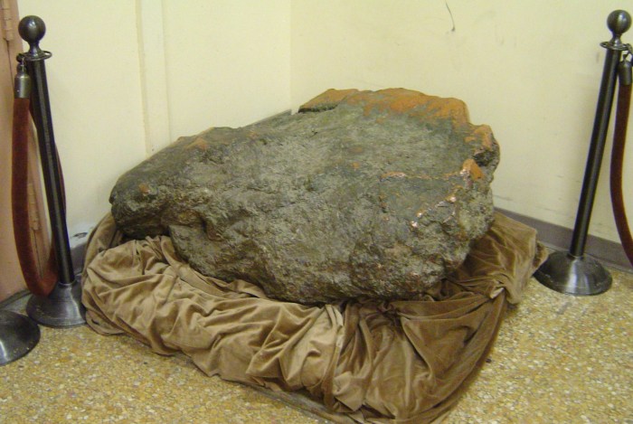
Ontonagon Copper Boulder at the Smithsonian by Ian Shackleford

Today’s post is what we call a foreshadowing in the photo blog game. It concerns the extremely messy saga of the Ontonagon Boulder which is now at the Smithsonian Museum of Natural History. You can (and should) read it all, but here’s some highlights:

In 1669 the French government sent Louis Joliet to search for copper deposits in the area. Joliet decided to discover the Mississippi River instead.

English adventurer and fur trader Alexander Henry trips up the Ontonagon River in 1765 and 1771. An underwhelmed (and astoundingly wrong) Henry was unimpressed writing, “The copper ores of Lake Superior can never be profitably sought for but for local consumption….” The 5 million plus tons of copper 5,400,000 disagree.

In 1819 Gen. Lewis Cass directed an expedition to the boulder & sought to move it by burning thirty cords of wood around the boulder & throwing water on the hot copper which didn’t succeed in fracturing the boulder.

In 1841, Detroit hardware merchant Julius Eldred and an interpreter set out to buy the boulder from the Chippewa on whose land it stood for $150. He failed that time & the next, but in 1843 with a portable railway & car managed to move it (after having to buy the rock AGAIN from some Wisconsin miners for $1,365).

From the U.S. National Museum report of 1895: For four miles and a half, over hills 600 feet high, through valleys and deep ravines; through thick forests where the path had to be cut; through tangled underbrush, the home of pestiferous mosquitoes, this railway was laid and the copper bowlder (sic) was transported; and when at last the rock was lowered to the main stream, nature smiled on the labors of the workmen by sending a freshet to carry their heavily laden boat over the lower rapids and down to the lake.

At this long-awaited, triumphant point, Eldred was confronted by an order from the Secretary of War to General Cunningham, directing that the copper boulder be seized for transportation to Washington.

“The persons [Eldred and his sons] claiming the rock have no right to it,” the Secretary decreed, “but justice and equity would require that they be amply compensated for the trouble and expense of its removal from its position on the Ontonagon to the lake; and for this purpose General C. will examine their accounts and allow them the costs, compensating them fully and fairly therefore, the sum, however, not to exceed $700….”

In the end & with the help of Congress, Eldred received $5,664.98 which is roughly $200,000 in today’s dollars.

Read lots more from the Smithsonian & also check out a more detailed look at the drama around Eldred from The Mining Journal.

The photo was taken by Ian Shackleford & appears in the Wikipedia entry for the Boulder

Support Michigan in Pictures with Patreon

Frozen Falls in FiveK

Frozen Munising Falls, Michigan by Tom Clark

Frozen Munising Falls, Michigan by Tom Clark

Tom took this shot last weekend at the 50-foot Munising Falls in the Pictured Rocks National Lakeshore. See more shots in Tom’s UP Trip for Ice 2-4-2022 album on Flickr & for sure zoom in for the crazy detail in this 5k photo!

Support Michigan in Pictures with Patreon

Sunrise #1,117 at Marquette’s Orehenge

Sunrise 1117 by Bugsy Sailor

Sunrise 1117 by Bugsy Sailor

On his Twitter, Michigan’s Sunrise King Bugsy Sailor shared a phenomenon that I’d never heard of – Orehenge! He writes: 

Twice a year, for a few days stretch, the sun rises down the center of the historic Marquette ore dock.

And oh boy, does the community loves it! Just as they should. But my introverted self, loving my mornings of solitude and meditation, has to overcome a lot of anxious energy to walk into a crowd during my most cherished time of the day.

Orehenge, as it’s affectionately called, falls in November and January, where the sun is really seen at sunrise. From my January data over three years, there is less than a 20% chance of seeing the sun at sunrise.

There’s more observations & photos of this very cool seasonal happening and the crowd that showed up @BugsySailor on Twitter. For sure check out his Twitter for more & if you’re low on Upper Peninsula swag, his UP Supply Co is a great source!

Support Michigan in Pictures with Patreon

#TBT: Walking with the Icefoot on Agate Beach

Winter morning on Agate Beach by Gary McCormick

Winter morning on Agate Beach by Gary McCormick

Here’s a special Science Term Throwback Thursday from January 14th 8 years ago!

Ernest W. Marshall talks about a common winter feature along considerable stretches of Great Lakes shorelines, the Icefoot, a narrow fringe of ice attached to the coast:

Air and water temperatures must be sufficiently low before an icefoot begins to form. The conditions favorable for icefoot formation are broad open shorelines gradually sloping below water level, and facing so that wind-blown spray is carried inland toward the shore to freeze. The character of growth of an icefoot differs during different periods of the winter. During the course of the winter the icefoot may suffer periods of denudation alternating with periods of accretion. The development of an icefoot can be held at one stage by the early freezing of fast ice offshore. An icefoot can be composed of any combination of frozen spray or lake water, snow accumulations, brash, stranded icefloes, and sand which is either thrown up on the icefoot by wave action or is blown out from the exposed beaches.

Observations of the icefoot along the shorelines of Lakes Superior and Erie indicated that the moderately steep portions of the shore were characterized by narrow terraces composed of frozen slush and brash thrown up by storm winds. The outer edge of this icefoot was often cusp-like in form, resulting from the mechanical and melting action of the waves. The inner portions of the cusps acted to concentrate the wave action, forming blowholes which threw spray back on the icefoot.

You can click to read more.

Gary took this photo at one of my favorite places, Agate Beach on Lake Superior in Grand Marais. In the distance is Grand Sable Dunes & the Pictured Rocks National Lakeshore. See more in Gary’s Grand Marais Michigan gallery including a shot of a staggeringly huge ice mound & view and purchase his work at Footsore Fotography.

Support Michigan in Pictures with Patreon

Before the Plows Come By

Before the Plows Come By by Ann Fisher

Before the Plows Come By by Ann Fisher

Ann captured a nice winter mood in this photo from a late December evening in Marquette. See more in her 2021 UP gallery on Flickr & thanks to all the hardworking plow drivers around the state!

Support Michigan in Pictures with Patreon

A New Blue at Adventure Mine

Blue Mineral at Adventure Mine

Blue Mineral at Adventure Mine

WWJ-Detroit shares that a bright blue mineral has been discovered at a mine on the Keweenaw Peninsula that so far has people perplexed:

The mysterious mineral was found on rock walls in the historic U.P. Adventure copper mine in Greenland Township, south of Lake Superior.

On Sunday, officials from the mine have posted pictures on Facebook of the mystery substance found on rock walls, but the bright blue material has not been positively identified.

Officials said they believe it to be a secondary mineral caused by a reaction with air and water. The mine operated from 1850 until 1920 and 11 million lbs. of native copper has been extracted.

Definitely visit the Adventure Mine website for information on their tours & the history of the mine.  In the Facebook post referenced, Adventure Mine said “This bright blue mineral has not been positively identified as of this post but it is a secondary mineral that is caused by a reaction with air and water. It was found on the 3rd level in a small stope.” A stope is an excavation in a mine working or quarry in the form of a step or notch & the comment thread has some very interesting ideas as to what the mineral could be.

My own personal pet theory based solely on how cool it would be is that this reaction is due to the same mineral that creates the unique iron ore slag known as Leland Blue

PS: After some discussion with Adventure Mine operators, I realize that I took my kids on a tour there 20 years ago. Super cool & a highlight of our visit to the awesome Keweenaw Peninsula – definitely put a trip to the copper-iest of Copper Country on your Michigan bucket list!

Support Michigan in Pictures with Patreon

Waterfall Wednesday: Reany Creek Falls

Reany Creek Falls by Aaron Strouse

Reany Creek Falls by Aaron Strouse

Waterfalls of the Keweenaw entry for Reany Falls says in part:

With a location close to a well-known Marquette destination (Dead River Falls) Reany Falls is a surprisingly photographed and popular waterfall. Composed a few small drops along a narrow creek, the main focus is a three-way split plunge nestled in the bedrock that is viewable from the road’s bridge above. Smaller drops are located above these falls, although the narrow little canyon makes viewing them difficult.

Aaron took this photo back in August of 2017. See more in his massive Michigan waterfalls gallery on Flickr.

More Michigan waterfalls on Michigan in Pictures!

Support Michigan in Pictures with Patreon

The name is Falls, Bond Falls

Misty Bond Falls by Yanbing Shi

Misty Bond Falls by Yanbing Shi

The GoWaterfalling entry for Bond Falls near Paulding in the Upper Peninsula, says (in part):

Bond Falls is in the western U.P. on Bond Falls Rd, east of Pauding MI. This is the most impressive waterfall in Michigan with the possible exception of Tahquamenon Falls. The main drop is 40 feet high and 100+ feet wide. Above the main falls are a series of cascades and rapids that must drop a total of 20 feet.

The water level is controlled by a dam, and a steady flow over the falls is maintained for scenic reasons. Of course during the spring melt the flow is much higher.

Bond Fall is a Michigan State Scenic Site. The site was renovated around 2003. The old parking area was upstream of the falls, and a steep concrete stairway led to the base of the falls. The new parking area is near the base of the falls, and a level boardwalk leads you to prime views of the falls. The area is not quite as wild looking as it once was, but it is accessible to everyone. The trail on the east side of the falls is still wild with some steep rocky climbs. There are other trails that go off into the woods, and there are campsites nearby.

In addition to being very picturesque, this is a very popular waterfall, and unless you visit early in the morning or in winter, you are going to have a lot of company.

Bringing back this November 2014 photo I featured of Bond Falls for another look! See more in Yanbing Shi’s Landscape gallery on Flickr.

Support Michigan in Pictures with Patreon