Fall Color on the Rouge River

Newburgh Bridge by River Wanderer

Newburgh Bridge by River Wanderer

River Wanderer shared this shot of the Newburgh Bridge along the Middle Rouge River, heading into Newburgh Lake on a beautiful day in October of 2016. See lots more on their Flickr page.

You can learn more about the Rouge River from Friends of the Rouge.

Support Michigan in Pictures with Patreon

Waterfall Wednesday: Potawatomi Falls on the Black River

Potawatomi Falls on the Black river in Gogebic County Michigan by Tom Clark

Potawatomi Falls on the Black River by Tom Clark

Waterfalls of the Keweenaw entry for Potawatomi Falls says in part:

A short distance below Great Conglomerate Falls is an awkward duplicate: Potawatomi Falls. Like its twin, Potawatomi is a split drop over a dome of conglomerate rock that creates two tall, curving waterfalls. However, this one is not split evenly. Much of the water is pushed to the eastern bank by an uneven riverbed to create a wide and multi-tiered drop. A few small streams converge for the other side and make for a smaller, but more direct, plunge.

As a bonus, it’s walkable to another beautiful waterfall, Gorge Falls.

Tom took this last month and you can see lots more in his excellent Waterfalls, Rivers & Streams gallery on Flickr & definitely follow Tom Clark Photography on Facebook for more great pics from his travels!

Support Michigan in Pictures with Patreon

Schooner on the Detroit Riverfront

Sunset Schooner by Jamie Feldman

Schooner on the Riverfront by Jamie Feldman

Jamie took this back in 2012 on the Detroit riverfront. See more at Feldman Images on Facebook!

More from the Motor City on Michigan in Pictures!

Support Michigan in Pictures with Patreon

Waterfall Wednesday: Manebezho Falls

Manabezho Falls by malderink

Manabezho Falls by malderink

GoWaterfalling’s page on Manebezho Falls says:

The Manabezho Falls are part of the Presque Isle River’s spectacular final dash to Lake Superior. The entire 1 mile stretch is very beautiful, with lots of bare rock and rapids. It is easily accessible from the Presque Isle entrance off of CR-519 on the western end of the park…

Manido Falls are just short distance upstream. Nawadaha Falls is a bit farther upstream. Downstream of Manabezho the river plunges into a narrow gorge. The “falls” there have no name, but they are quite interesting.

The falls are located in the Porcupine Mountains State Park. More Michigan waterfalls on Michigan in Pictures!

This photo is from a couple of weeks ago. Head over to malderink’s Flickr for more!

Support Michigan in Pictures with Patreon

Reflections on Fall Color

Reflected colors by Ann Fisher

Reflected colors by Ann Fisher

“How beautifully leaves grow old. How full of light and color are their last days.”
– John Burroughs

Ann took this photo back in October of 2015 on the Dead River, just west of Marquette in the Upper Peninsula. See more in her 2015 U.P. Gallery.

Support Michigan in Pictures with Patreon

Waterfall Wednesday: Gabbro Falls on the Black River

Gabbro Falls on the Black River in Gogebic County Michigan by Tom Clark

Gabbro Falls on the Black River in Gogebic County Michigan by Tom Clark

Tom took this photo last week & writes:

Gabbro Falls is on the Black River and is as impressive, if not more impressive, than its more celebrated neighbors downstream along the Black River Scenic Byway. This is a largely wild waterfall with no fences or barriers of any kind. It consists of three separate drops. When the water is high there is a fourth drop that is the height of the other three combined that can only be seen from the east side of the river. The main drop falls into a narrow crevice between two large rock formations.

See more in Tom’s North Shore Waterfalls Trip album on Flickr.

You can read more about Gabbro Falls & more about the Black River Scenic Byway on Michigan in Pictures!

Support Michigan in Pictures with Patreon

Waterfall Wednesday: Bond Falls

Bond Falls - Paulding MI by SueFi Photography

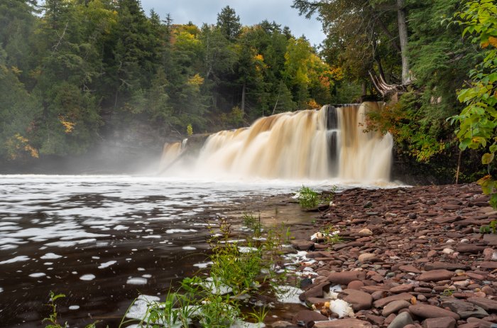
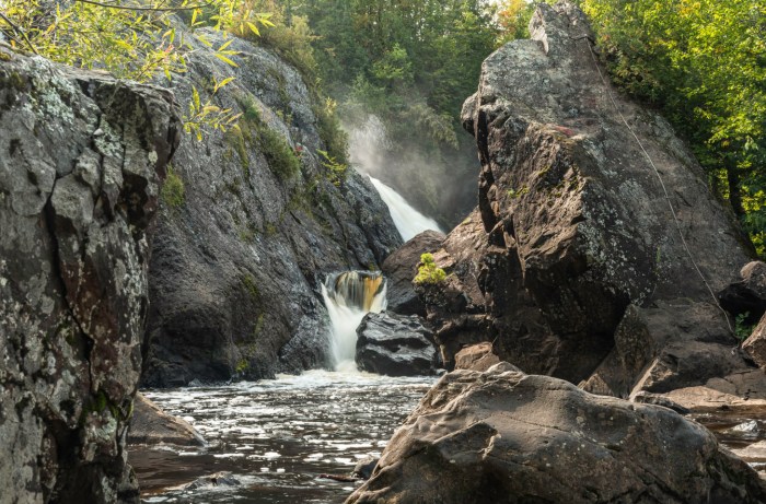
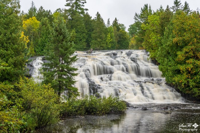
Bond Falls – Paulding MI by SueFi Photography

GoWaterfalling should be your go-to site for exploring Michigan waterfalls. Their entry for one of Michigan’s most beautiful waterfalls, Bond Falls near Paulding in the Upper Peninsula, says (in part):

Bond Falls is in the western U.P. on Bond Falls Rd, east of Pauding MI. This is the most impressive waterfall in Michigan with the possible exception of Tahquamenon Falls. The main drop is 40 feet high and 100+ feet wide. Above the main falls are a series of cascades and rapids that must drop a total of 20 feet.

The water level is controlled by a dam, and a steady flow over the falls is maintained for scenic reasons. Of course during the spring melt the flow is much higher.

Bond Fall is a Michigan State Scenic Site. The site was renovated around 2003. The old parking area was upstream of the falls, and a steep concrete stairway led to the base of the falls. The new parking area is near the base of the falls, and a level boardwalk leads you to prime views of the falls. The area is not quite as wild looking as it once was, but it is accessible to everyone. The trail on the east side of the falls is still wild with some steep rocky climbs. There are other trails that go off into the woods, and there are campsites nearby.

In addition to being very picturesque, this is a very popular waterfall, and unless you visit early in the morning or in winter, you are going to have a lot of company.

Sue took this last weekend. See more on her Flickr & definitely follow SueFi Photography on Facebook for more!

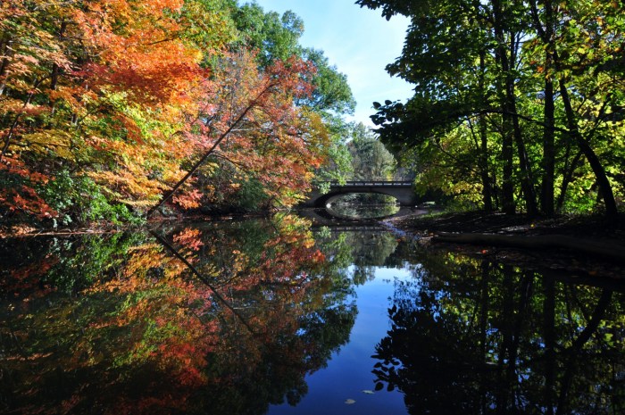
Tons more Michigan waterfalls on Michigan in Pictures!

Support Michigan in Pictures with Patreon

Tahquamenon: The River of a Hundred Bends

Tahquamenon River by Jim Sorbie

According to Wikipedia’s entry for the 89-mile long Tahquamenon River in the eastern Upper Peninsula:

The river is best known for the Tahquamenon Falls, a succession of two waterfalls in Tahquamenon Falls State Park totalling approximately 73 feet (22 m) in height. Because the headwaters of the river are located in a boreal wetland that is rich in cedar, spruce and hemlock trees, the river’s waters carry a significant amount of tannin in solution (i.e., it is a blackwater river), and are often brown or golden-brown in color. The Tahquamenon Falls are thus acclaimed as being the largest naturally dyed or colored waterfall in the United States.

The meaning of “Tahquamenon” is not known. Some called it the “River of the Head Winds” because they bucked the wind on the lower river no matter what direction they were paddling. Others called it the “River of a Hundred Bends”. Twentieth century descendants of local Chippewa translated the name to mean “river up against a hill” or “lost river island” or “river with an island part way”. In 1930 Jesuit scholar, Father William Gagnieut, concluded that the meaning of the name had been lost.

Jim took this in early July. Check out more in his awesome From the Air gallery on Flickr!

Support Michigan in Pictures with Patreon

High water forcing some closures

Buoyant Joy by Mark Smith

Buoyant Joy by Mark Smith

mLive’s Emily Bingham reports that historically high water levels are closing campsites, harbor slips at popular state parks across Michigan:

During a summer recreation season already hampered by pandemic-related delays and restrictions, many of Michigan’s state parks are now wrestling with another force of nature: historically high water along the Great Lakes.

From the east side to the west side and up north, the record-setting water levels are reshaping shorelines, eroding beaches, submerging docks and piers, and rendering roads and trails inaccessible. The unprecedented situation has manifested in high water-related closures statewide at harbors, parks and boating access sites managed by the Michigan Department of Natural Resources.

…A number of boating access sites and fishing piers across the state are temporarily closed on account of high water as well; a full list of closures and updates is available at Michigan.gov/DNRclosures.

Leland’s popular Fishtown is one place with critically high water levels. You can see Mark’s photo of the Joybigger on his Facebook & for sure follow him on Flickr @downstreamer!

Support Michigan in Pictures with Patreon

The other side of O Kun de Kun Falls

O-Kun-de-Kun Falls by Michigan Nut Photography

O-Kun-de-Kun Falls by Michigan Nut Photography

GoWaterfalling is simply the best website for Upper Peninsula waterfalls. In addition to detailed directions, they share that O Kun de Kun Falls:

…is one of the largest of the waterfalls in Ontanagon county. It is not as large as Bond Falls or Agate Falls, but it is just as scenic and far wilder. It is a mile plus hike to O Kun de Kun Falls and there are no fences or signs. The waterfall is also unusual in that it is an actual plunge falls. Only a handful of the many waterfalls around Lake Superior are plunge falls. You can go behind the falls if you want, but you need to be careful and sure footed.

…The width of the falls varies wildly depending on water levels. The Baltimore River can get pretty thin in summer months.

The waterfall is named after an Ojibway chief.

John took this from behind the falls last week and notes that the Baltimore River is a warm, slow moving river. Click to view it on Facebook and definitely follow him on Facebook & Instagram and order prints & more at michigannutphotography.com!

See many more Michigan waterfalls on Michigan in Pictures!

Support Michigan in Pictures with Patreon