place of the sauk, photo by gsgeorge.
BLAND, BOARDED AND CRACKED, WITH AN UNCERTAIN BOTTOM LINE WITH NO FOCUS – NOT UNLIKE THE TOWN I’VE LIVED IN ALMOST ALL OF MY LIFE. THIS IS WHAT IT HAS BECOME. -SAGINAW, MICHIGAN
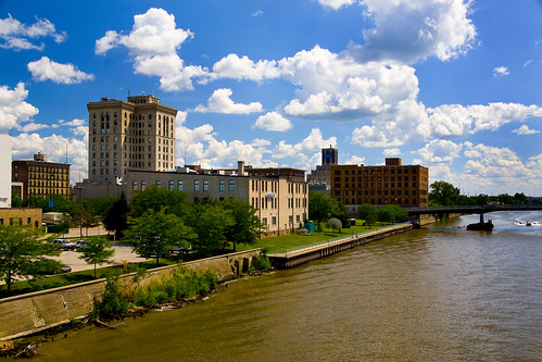
Now, I happen to like that photo quite a lot, but it’s certainly not a photo that shouts “move yourself or your business to Saginaw or just drop by for a visit” as a photo like this one by Geoffrey George does. (view larger). Since the other picture is the first thing that pops up on a search for “saginaw michigan photo”, we probably better address that.
The Saginaw Library details the history of Saginaw and says that there is archaeological evidence Paleo-Indian nomads in the Saginaw Valley from 12,000 years ago (some of the most valuable archaeological sites in Michigan are in the area). Woodland cultures including the mound-building Hopewell Indians settled along the Saginaw River. According to the library, name Saginaw is derived from an Ojibway term “O-Sag-e-non” or “Sag-in-a-we” that means “to flow out” and probably refers to the outflow of the Saginaw River into the Saginaw Bay. However, there are also those who believe that Saginaw is derived from Sagina’we’, signifying ‘the country or place of the Sauk’.
The library’s history goes on to explain how the American Fur Company established a trading post on the west side of the Saginaw River after the War of 1812, and how Saginaw City was founded by Norman Little in 1836. Both the article and Wikipedia’s entry on Saginaw, Michigan detail how Saginaw’s easy access to waterways served to fuel growth as Michigan’s massive white pine forests were felled and shipped around the nation in the 1800s. Soon after the close of the lumbering era, a new industry: the auto industry.
In Saginaw, the Jackson, Wilcox and Church Company produced carriages to be drawn by horses, and later produced components used in motor vehicles. This was eventually acquired by General Motors and formed the basis for its Steering Gear division. Additionally, General Motors established foundries and other manufacturing facilities in Saginaw. The early development of automotive production within Saginaw would set the course for the future economic circumstances of the City. (click for photo from the early automotive industry in Saginaw)
Modern day Saginaw has faced major challenges due to manufacturing job loss, but community leaders are actively seeking new industries through initiatives such as those listed on The Saginaw Valley. You will also want to explore the area through the Saginaw Chamber of Commerce, the Saginaw Valley Convention & Visitors Bureau and the City of Saginaw, Michigan.
You can see where this picture was taken (along with many more) on the Flickr photo map of Saginaw, MI and also see more photos from the past and modern day in the Saginaw, Michigan group on Flickr. Please also feel free to add your own thoughts on Saginaw or links to more information in the comments!
Share Michigan in Pictures:


