Real-time Great Lakes Surface Currents

Get Up - Stand Up

Get Up – Stand Up, photo by Rudy Malmquist

The Great Lakes Echo highlighted a really cool realtime map of Great Lakes surface currents that can really help keep you safe whether you’re swimming, boating, surfing or stand-up paddleboarding. It might even help you find a fish or two!

Check this out background bigtacular and in Rudy’s water slideshow.

Thunder Bay National Marine Sanctuary could grow tenfold

F.T. Barney exploration, photo courtesy Thunder Bay National Marine Sanctuary

The Thunder Bay National Marine Sanctuary is the only federally protected national marine sanctuary in the Great Lakes. It encompasses 448 square miles of Lake Huron’s bottomlands off Alpena. It was established in 2000 to protect a nationally significant collection of nearly 200 shipwrecks, spanning over a century of Great Lakes shipping history. It draws over 70,000 visitors every year and is a haven for protection, education and research for shipwrecks and our maritime heritage.

Now Thunder Bay is poised to grow almost tenfold to over 4,000 square miles including waters off Alcona and Presque Isle counties. The Great Lakes Echo notes that today is the last day for public comment for or against the expansion. You can email your comments to jeff.gray@noaa.gov. Carolyn Sundquist of the Echo explains that vessels can pass through it without restriction and that:

The proposed expansion includes an estimated 200 shipwrecks and would connect the underwater sanctuary from Michigan to the shores of Canada. No public funds are allotted as part of the approval.

“Very positive support has been received from the public comment sessions and many of the local governments have passed resolutions supporting the expansion,” said Jeff Gray, the sanctuary’s superintendent.

Michigan Gov. Rick Snyder, various state senators and officials of adjacent cities have written letters of support. So has the Alpena Area Chamber of Commerce.

The Sanctuary explains that the 126′ two masted schooner F.T. Barney was built in 1856 and wrecked on October 23, 1868 en route from Cleveland to Milwaukee. The F.T. Barney was run into by the schooner T.J. Bronson and sank in less than two minutes in very deep water with a cargo of coal. No lives were lost, and the wreck is one of the most complete of its kind with masts and deck equipment still in place.

See many more shots of divers and shipwrecks in their Fieldwork 2007 gallery – be sure to toggle the “View” link to slideshow in the top left for larger pics.

Many more Michigan shipwrecks on Michigan in Pictures!

Middle Island Lighthouse in Lake Huron

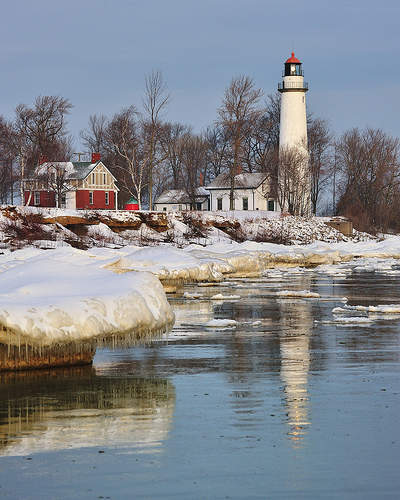
Middle Island Light Station as viewed from the watch room gallery, photo by Terry Pepper

The Middle Island Light Keepers Association (MILKA) and the Great Lakes Lighthouse Festival “Museum” invite you to be a part of history on Monday, May 28, 2012. On that day, the General Service Administration will deliver a quitclaim deed and the U.S. Coast Guard will deliver the key and ownership and responsibility for upkeep, maintenance and preservation to MILKA. To commemorate this historic event, ferry service will be available to Middle Island (weather permitting), where the tower will have its first official opening to the general public. There will be hot dogs, refreshments, a “Joy Ride” Island Tour, tours of Middle Island Light Station and much more!

The Middle Island Lighthouse page at Terry Pepper’s Seeing the Light begins:

Situated approximately 6.5 miles north of Potter Point, Middle Island received its name as a result of its location midway between the North Point of Thunder Bay and Presque Isle. The island had long represented a “triple-edged sword” to mariners. Marking a turning point in the course for vessels making up and down the coast, the island’s lee side also represented an excellent harbor of refuge in which to escape Huron’s fury. However surrounded with shoals with depths of less than six feet on all but its northeast side, the refuge could be hard to find in dark of night or in the thickest weather. In fact, the area was considered dangerous enough that the Life Saving Service built a station on the island in 1881 to help service ships in distress in the area.

As one of the final links in a growing chain of coast lights being constructed along Huron’s western shore, the Lighthouse Board finally recommended that an appropriation of $25,000 be made for a light and fog signal on the Middle Island’s eastern shore in its annual report of 1896. With no appropriation forthcoming, the Board reiterated its request in each of its annual reports for the following six years, until Congress finally responded favorably with the requested appropriation on March 3, 1902.

Read on for more including photos of the station and also see a map with the location of Middle Island Lighthouse. Following the closure of the station, the tower and outbuildings were seriously vandalized. In 1992, a group of concerned citizens in the Alpena area formed the Middle Island Lighthouse Keepers Association in 1992. They converted the fog signal building into the Middle Island Keepers’ Lodge, which opened for business in 2003. Visit that site for photos of the lodge and reconstruction efforts.

Terry Pepper is the Executive Director of the Great Lakes Lighthouse Association and maintains the fantastic Seeing the Light website, a guide to the lighthouses of the western Great Lakes. While he’s appeared as a resource for many of the lighthouse features on Michigan in Pictures, this is the first using his photos!

Wintertime at Aux Barques Lighthouse, Port Hope, Michigan

Wintertime at Aux Barques Lighthouse, Port Hope, Michigan

Wintertime at Aux Barques Lighthouse, Port Hope, Michigan, photo by Michigan Nut.

The page on the Pointe Aux Barques Lighthouse at Terry Pepper’s Seeing the Light says that about 75 miles north of Fort Gratiot light and two miles from shore in Lake Huron, there’s a shallow reef with only two feet of water above it. It was right where northbound vessels made their swing into Saginaw Bay, and Michigan State Representative Isaac Crary entered a motion in Congress in 1838 to establish a lighthouse on the shore to warn mariners and mark the turning point:

Congress responded with an appropriation of $5,000 for the Light’s construction on July 7, 1838.

While conducting his annual inspection of lighthouses on the lakes and selecting sites for proposed new stations a month later, Lieutenant James T Homans arrived in the area to select the site for the new station. In his report to the Fifth Auditor of the Treasury for the year, Homans reported that he selected “the most westerly of the two points, known as Point-aux-Barques, near the entrance to Saganaw Bay (sic), for the light there, because it is sooner seen by vessels approaching from the northward and westward, by which it will be most used; also, as being near a shoal, dangerous to the navigation of its vicinity.” Homans went on to report that “There is stone in considerable quantity near this location, which can be used in constructing the buildings. The land, I presume, belongs to the Government, or can be had for a moderate price, there being no settlements within several miles, and the soil very barren.”

Government apparently moved no faster then than now, and it wasn’t until 1847 that the structure was completed. There’s much more about the lighthouse and the Port Hope Lifesaving Station including photos if you read on at Seeing the Light.

The Pointe Aux Barques Lighthouse Society has the text of the contract to construct the light along with a few photos and more information including the keeper logs from 1923.

John took this photo at the end of January. You can see it bigger and see more from the area on his map. Don’t miss the Michigan Nut Photography Facebook page either!

Lake Michigan was first

Lake Michigan

Lake Michigan, photo by GLASman1.

This coming Thursday (January 26) is Michigan’s 175th Birthday (#mich175 on twitter). We’re making a big fuss of it with a 175th Birthday Bash on Absolute Michigan, and this morning I inadvertently stumbled on a piece of Michigan’s heritage that I guess I never really thought about.

Wikipedia’s Lake Michigan entry begins:

Lake Michigan is one of the five Great Lakes of North America and the only one located entirely within the United States. The other four Great Lakes are shared by the US and Canada. It is the second largest of the Great Lakes by volume and the third largest by surface area, after Lake Superior and Lake Huron (and is slightly smaller than the U.S. state of West Virginia).

Hydrologically, the lake is a large bay of Lake Michigan-Huron, having the same surface elevation as Lake Huron (among other shared properties). It is bounded, from west to east, by the U.S. states of Wisconsin, Illinois, Indiana, and Michigan. The word “Michigan” originally referred to the lake itself, and is believed to come from the Ojibwa word mishigami meaning “great water”.

It makes complete sense to me that the Lake was first. However, since I’m pretty much never able to leave ambiguities un-investigated, I dug up a discussion thread about the origin of “Michigan” from the Ojibwe Language Society Miinawaa. One member listed a few variants:

mishigami = large lake
mishigamaa = large lake
mishi’igan = large lake
mishigaam = large shoreline

and then another member wrote

my understanding of the word ‘Michigan’–which may be different from others’–is that it comes from ‘michi-zaaga’igan’, which means ‘only/just/nothing else but a lake’ [michi ‘only, just, that’s all there is’ + zaaga’igan ‘lake’].

If you think about Lake Michigan and Lake Huron and how you might perceive them before aerial capability or maps, wouldn’t they seem like one big lake to someone questing to walk or paddle the shoreline of Michigan’s Lower Peninsula? The “only lake”? Love to hear your thoughts in the comments.

Check this out bigger and in Mark’s Point Betsie Lighthouse slideshow.

More Lake Michigan on Michigan in Pictures.

Ice Islands, Ice Beasts

Ice Islands

Ice Islands, photo by Silver Cat Photography.

Here’s a crazy shot from last year on Lake Huron near Oscoda in the Ice Beast group that I created. Winter has finally arrived in force and our Great Lakes have once again become home to the fearsome and beautiful Ice Beasts. If you have captured these rare creatures, please share your photos in the group!

Click here to see it bigger and see more in Sliver Cat Photography’s winter slideshow.


“Winter’s palette” at Tawas Point State Park

"Winter's palette" Tawas Point State Park - East Tawas, Michigan

“Winter’s palette” Tawas Point State Park – East Tawas, Michigan, photo by Michigan Nut.

On another photo from Tawas Point John writes:

Anywhere you live in Michigan, you can’t be more than 85 miles from a Great Lakes Shoreline, and you cant be more than 6 miles from a natural water source; Michigan has 64,980 inland lakes.

I can’t imagine living anywhere else. But I know, others feel the same about their own paradise.

I can’t imagine living anywhere else either. Here’s the state’s Tawas Point State Park page.

Check John’s photo out on black and see some more stunning photos by John from Tawas Point (including the lighthouse) in his slideshow and definitely tune into Michigan Nut Photography on Facebook!

Where does Michigan begin?

Perkins + WIll 35
Perkins + WIll 35, photo by orijinal

The headline of Gary Wilson’s editorial at the Great Lakes Echo caught my eye this morning: Great Lakes: A ship with no name in search of a captain. Gary begins:

In the past two weeks Chicago has been the center of a rare commodity in the Great Lakes region: Forward-looking thought. And I mean the future, not just until the next election or fiscal year.

P-17= Steel Mills at mouth of Calumet river Chicago. Fire and boat at left. C.W. Cushman Nedill
Steel Mills at mouth of Calumet river Chicago by IMLS DCC

First, architect and MacArthur Foundation “Genius Award” winner Jeanne Gang presented her vision for transforming the Chicago River from that of an “open sewer” and invasive species highway to becoming a model of a 21st century urban waterway.

Gang’s proposal is conceptual, not an engineering plan. It’s meant to generate interest by the public and discussion that has been lacking. And judging by the large crowd that came to hear her speak, that interest exists.

At the same time Chicago Public Radio was also looking to the future.

Its Front & Center series that focuses on the Great Lakes hosted a one hour program about whether the region can truly collaborate for the greater good of the eight Great Lake states. Or will it continue to play in a zero sum economic game by competing with each other while the region’s combined strengths go untapped?

The consensus of the expert commentators is that the region’s governors see no political gain by collaborating. They’re focused on winning the jobs takeaway game that makes for nice press releases and ribbon cutting ceremonies when they win, but does nothing to strengthen the region.

Excellent questions. Read on for his thoughts about where the leadership to protect the amazingly interconnected wonder that are Lakes Michigan, Huron, Superior, Erie and Ontario may (or may not) come from .

There’s no doubt that it will take all the states on the lakes and the governments of the United States and Canada and their citizenry to do it. I’m pretty confident that the character & vision of our leaders and all of us on the Great Lakes will be important to generations yet unborn.

Turning Basin
Turning Basin by mindfrieze, photo by mindfrieze

Editor’s note: this isn’t the first time that Michigan in Pictures has featured multiple photos – more in the Sunday Study section. These also aren’t the first photos from outside of Michigan’s borders to appear on Michigan in Pictures – at least one is the Christmas Ship at the dock in Chicago.

Remembering the Carl D. Bradley

Carl D Bradley on the Great Lakes

Bradley – Color – 300 dpi, photo by Presque Isle County Historical Museum.

23 women became widows in that instant and 53 children lost their fathers.
~Rogers City resident on the sinking of the Bradley

The Edmund Fitzgerald gets the majority of the attention when Michigan shipwrecks are discussed, but it can be argued (very convincingly) that the wreck of the Carl D Bradley on November 18, 1958 was the greatest of Great Lakes tragedies. 33 of 35 crewmen – most from her home port of Rogers City – perished, leaving the small city in northeastern lower Michigan stunned by grief.

Over on Absolute Michigan today we have an excellent feature from the Archives of Michigan on the Wreck of the Carl D. Bradley that includes a riveting video from the documentary November Requiem. An article by Warren J. Toussaint about the sinking begins:

Tuesday, Nov. 18, 1958, at 5:31 p.m., the limestone carrier, Carl D. Bradley, was up bound on Lake Michigan, having delivered her last limestone cargo of the year to Indiana on November 17,1958. She stayed close to the Illinois and Wisconsin shores because of reports of severe weather conditions rapidly developing from the west. As it reached the area of Sturgeon Bay, Wis., it had to turn to the northeast in order to cross the upper area of Lake Michigan on its way to the homeport of Rogers City, Mich., on Lake Huron. Suddenly, the Bradley’s steering wheel went slack, as if the gears had suddenly disconnected. On the course it was on, the winds and waves were striking the ship on the aft quarter of the port side causing the ship to rock severely. First Mate, Elmer Fleming, knew the ship was in trouble. He jerked the radio telephone from its cradle and shouted a desperate call “Mayday, Mayday, – Mayday. This is the Carl D. Bradley. Mayday Mayday Mayday.”

Read on and see much more at carldbradley.org!

The photo is one of the last known photos of the Steamer Carl D. Bradley, taken after she passed under the Mackinac Bridge and was making the turn to the southeast to set a course for Rogers City. Check it out background big and in their great Bradley Transportation Fleet slideshow. Definitely have a look at the Presque Isle County Historical Museum website for more on the Bradley and the history of the region and to order the Bradley DVD!

Battered but not Beaten: Great Lakes Week 2011

Battered

Battered, photo by James Marvin Phelps.

Invasive species, pollution, diversion – the threats facing the Great Lakes are legion.

This week (October 11-14) is Great Lakes Week, a partnership to improve the places around the Great Lakes basin basin where people live, work, learn and play. This week’s activities, meetings and conferences bring representatives of the U.S. and Canadian governments together in Detroit along with a broad coalition of public and private groups to highlight efforts to implement solutions for the lakes’ most pressing problems. It’s one of the most wide-ranging Great Lakes summits in history and you can watch it LIVE today starting at noon through Friday on Absolute Michigan or at greatlakesnow.org.

Check this photo of the Grand Haven Pier Light out background big and in James’ Michigan Lighthouses slideshow.