Northern Lights likely this week!

Northern Lights

Northern Lights, photo by BeaverTripp

The Space Weather Prediction Center of the National Oceanic and Atmospheric Administration says that minor to moderate auroral activity is likely through January 20th. Translation? Northern Lights are likely this week!

You can click to register for space weather alerts and also view the current space weather.

Stephen captured this photo in July of 2012 on Moss Lake in the U.P. Check his photo out as big as the sky and in his Northern Lights slideshow.

Much (much) more Aurora Borealis information & photos on Michigan in Pictures!

Superior Light Show

Superior Light Show_1283

Superior Light Show_1283, photo by Mike Hainstock

Light shows in the UP are typically of the Northern Lights variety, but Mike has captured a stunning view that I think is the lights of Baraga as seen from L’Anse though  it could be the other way around. Update – Mike comments below that it is L’Anse from Baraga. 

In any case, it’s awesome. Be sure to check this out on black and see more in Mike’s slideshow.

PS: Nice matching shot for Thursday’s photo too!

Know Your Michigan Waterfalls: Morgan Falls Edition

Calming Currents - Morgan Falls (Marquette, MI)

Calming Currents – Morgan Falls (Marquette, MI), photo by Aaron C. Jors

GoWaterfalling’s page on Morgan Falls explains that:

Morgan Creek tumbles 20 feet into the Carp River, creating this small wild waterfall. This is one of the more accessible of the Marquette waterfalls. The more impressive, but much hard to visit Carp River Falls are half a mile away.

Morgan Falls is located about two miles south of the city of Marquette. Of the many waterfalls in Marquette county this is one of the easier to visit, especially if you have four wheel drive. The waterfall is located at the confluence of Morgan Creek and the Carp River. The creek cascades down 20 feet to join up with the Carp.

…There is some disagreement about the name of this falls. According to some Morgan Falls is actually a cascade further upstream, and this is just an unnamed waterfall. This is the more distinctive and photogenic of the two features.

Read on for more information including directions.

You can view this photo on black. Aaron has several more great waterfall shots on Michigan in Pictures and even more in his Michigan waterfalls slideshow.

There are even more Michigan waterfalls on Michigan in Pictures too!

Detroit Panorama: City Lights Mix

Detroit, MI

Detroit, MI, photo by w4nd3rl0st (InspiredinDesMoines)

Jason put this photo together from about a dozen HDR images taken from a large park in Windsor. He notes that if you make the trek across the Detroit River, the Tunnel BBQ in Windsor is tasty and affordable.

For a real treat, view his photo background bigtacular and see more in his Detroit & Michigan slideshow.

Lots more from Detroit on Michigan in Pictures.

Eben Ice Caves in the Rock River Wilderness

A Healthy Green Glow

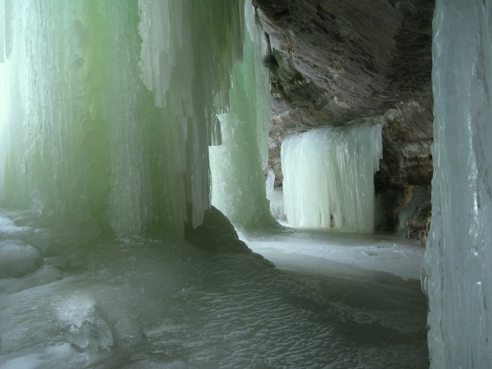
A Healthy Green Glow, photo by nasunto

I know it’s wintertime when I start seeing a lot of people asking about the Eben Ice Caves. Like many of the subjects on Michigan in Pictures, I don’t know much more than what I write on the blog. Recently, however, a good-hearted soul created the Eben Ice Caves Facebook page to serve as a hub for information about this wintertime wonder of Michigan.

Nina Asunto writes one of my favorite blogs, Black Coffee at Sunrise, a delightful wander through some of Michigan’s most fascinating places. Nina’s feature on the Eben Ice Caves explains that they are located in the Rock River Wilderness in the western section of Hiawatha National Forest.

Rock River Canyon is 150 feet deep and lined with sandstone outcrops, which have been eroded to form concave overhangs. During winter, ground water seeps over the edge and down through the sandstone where it freezes, creating huge curtains of ice and closing off the front of the outcrops to form caves.

In winter it is possible to access the ice caves from the south side of the wilderness area. A few miles north of Eben Junction, visitors can park their cars by the side of the road and cross an open field to the forest. The field is private property, but the owner allows for its use in winter to access the ice caves…

We had both seen a few photos of the ice caves, but none of them really captured the size of this phenomenon…

What we weren’t able to capture, however, was the amazing sound inside the cave. The drips of water falling from above created wonderful echoes and added to the cave atmosphere. There is much variation of color and texture to the ice in different parts of the cave. Some formations were smooth and clear, others were bumpy and hollow-sounding, and there were some columns that looked like dripping candle wax.

Read on for many more photos. You can also view this photo background bigtacular and see more in her fantastic Eben Ice Caves slideshow on Flickr!

More Eben Ice Caves on Michigan in Pictures.

Bald Eagle in Michigan

Eagle turning

Eagle turning, photo by Deirdre Honner

I think this is one of the best bald eagle photos I’ve ever seen. The Michigan DNR’s bald eagle page explains that before European settlement, bald eagles probably nested in all regions of Michigan.

In the early 1900s they were described as being “generally distributed,” but “nowhere abundant.” A decline through the early and mid-1900s was probably related to slow but consistent loss of suitable habitat and available food, and predator control by humans. These eagles are so disturbed by the presence of humans near their nest that they may be induced to abandon the nest, or even chicks that have already hatched. By 1959, the species was considered, “largely restricted to the northern half of the state.”

…Nests are usually constructed near seacoasts, lakes or large rivers to be near their most common food supply: fish. Although they are quite capable of catching their own, sometimes even wading in shallow water to stalk fish like herons, they have often been seen stealing fish from other birds such as osprey. When fish are not available, such as in winter, eagles will also feed on waterfowl, small mammals (up to rabbit-size) and carrion (even road-kill).

During Michigan winters, bald eagles are seen throughout the state (almost all counties), while they nest mainly in the Upper Peninsula (especially the western portion) and the northern portion of the Lower Peninsula. These eagles don’t really migrate, they just move south enough to stay ahead of the ice and congregate near open water. Immature birds may move further south.

Lots more about bald eagles at All About Birds and you can also view recent Michigan bald eagle sightings.

Check this out background big and see more including a shot of the eagle in flight  in Deirdre’s slideshow.

More Michigan birds on Michigan in Pictures.

Winter Driving? There’s a school for that…

Winter Driving

Winter Driving, photo by p912s (Scot)

On Absolute Michigan we just updated a feature on the Winter Driving School offered at Michigan Tech. It has some great tips and a very nice video that can help to make you a better winter driver today – click here to check it out!

Check this out background big and see more in Scot’s Winter slideshow.

The Ruins of the Cheboygan Point Lighthouse

Cheyboygan Lighthouse

The Cheboygan Point Lighthouse Ruin, photo by joeldinda

Terry Pepper’s Seeing the Light has information about the ruins of the Cheboygan Main Light Station, explaining:

Located directly across the three mile width of the Straits from the southernmost point of Bois Blanc Island, the eastern prominence of Duncan Bay marked a natural turning point for vessels entering the Straits, and the growing bounty of Lake Michigan beyond.

On December 21, 1850, Congress appropriated the sum of $4,000 for the purchase of a 41.13 acre reservation on what would become known as “Lighthouse Point” at the western end of Duncan Bay for the construction of the first Cheboygan light station … The tower was evidently poorly located, as high water was found to be undermining the stone foundation soon after construction. Fearing collapse was imminent, in 1859 the newly-formed Lighthouse Board decided to build a new station and demolish the original tower, only eight years after its construction.

The replacement station, was similar in design to that built at Port Washington the following year, consisting of a combined keeper’s dwelling and tower, with the tower located at the north apex of the hipped roof. The tower stood thirty-one feet above the foundation, and was capped with an octagonal iron lantern into which the Fresnel from the old tower was carefully relocated. The lights’ thirty-seven foot focal plane provided a twelve mile range of visibility, thereby providing coverage throughout the Straits.

Read on the story of how the second lighthouse ultimately met its end and some great old photos of the lighthouse. It’s located in Cheboygan State Park.

Joel writes that they walked the park’s Yellow Trail to the long (2 miles in the park) beach and walked along Lake Huron’s Mackinac Strait. View his photo background bigtacular, see it on his map and check out more great shots in his Cheboygan slideshow.

Many more Michigan lighthouses on Michigan in Pictures.

I Love Ice

I Love Ice_0746

I Love Ice_0746, photo by Mike Hainstock

As long as it’s not under my tires, I love ice too.

Check this photo out on black and see more in Mike’s spectacular ice slideshow which includes some photos from the soon-to-form Eben Ice Caves.

More ice on Michigan in Pictures.

211 West Fort Street, Detroit

211 Fort Detroit

211 Fort Detroit, photo by Mark Hall Aka Mark The kid

Wikipedia says that 211 West Fort Street is a 27 story skyscraper that was completed in 1963. Current tenants include the Detroit Economic Club, the Bankruptcy Court of the Eastern District of Michigan and the United States Attorney.  If you’re a measuring sort of person, it’s the 18th tallest building in Detroit, right after the David Broderick Tower.

Check this out big as a building and see more in Mark’s slideshow.

More architecture on Michigan in Pictures.