British General Brock of the Michigan Command ordered Captain Roberts, on St. Joseph Island, to attack the American Fort on Mackinac Island. That morning Captain Roberts embarked for Michilimackinac on the Northwestern Fur Company’s ship, Caledonia, with two six-pound guns, ten batteaux (flat-bottom boats), and seventy canoes. Captain Roberts’ force was composed of 42 regulars and 4 officers, 260 Canadians, 572 Chippewas and Ottawas, 56 Sioux, 48 Winnebagoes, and 39 Menomonies. The British arrived at Mackinac Island at 3:00 a.m. on July 17.
Fort Mackinaw’s American commander, Lieutenant Hanks, immediately prepared for action. However, around 9:00 in the morning he discovered that the British were in possession of the higher ground above the fort and that British artillery was already directed at the Americans’ most defenseless position. At 11:30 in the morning, the British sent in a flag of truce and the fifty-seven United States officers and enlisted men at the Fort surrendered.
After this victory, the British constructed Fort George (now known as Fort Holmes) about a half-mile behind the main Fort in order to protect it during future invasions. Great Britain retained control of Fort Mackinaw until the United States won it back in the Treaty of Ghent in 1815.
Space.com says that those who have gotten up before sunrise to gaze into the twilight skies to see Comet Neowise have been greeted by the best comet performance for Northern Hemisphere observers since the 1997 appearance of Comet Hale-Bopp, emphatically ending nearly a quarter-century of lack of spectacular comets, and it’s only going to get better:
The first good opportunity for evening viewing begins on July 12, when the head of the comet will stand 5 degrees above the north-northwest horizon, 80 minutes after sunset (the end of nautical twilight). By July 14 its altitude will have already doubled to 10 degrees, and by July 19 it will have doubled yet again to 20 degrees up by the end of nautical twilight. By then it will have moved to above the northwest horizon.
So, we at Space.com feel that the best time to view the comet during the evening will come during the July 14-19 time frame.
We also strongly recommend that observers should seek the most favorable conditions possible. Even a bright comet, like this one, can be obliterated by thin horizon clouds, haze, humid air, smoke, twilight glow and especially city lights. We especially emphasize that last factor: the farther away you get from a metropolitan area, the darker your sky and the better your view of NEOWISE. Binoculars will enhance your view.
And more good news: No moonlight will brighten the sky, as the moon will be a waning crescent and visible only in the morning sky through July 20. On successive July evenings the comet will grow fainter, but it will be farther from the sun, setting later and visible in a darker sky. As we move into August, the comet will be very well placed for observers with small telescopes.
Read on for more tips & happy comet hunting to you all!
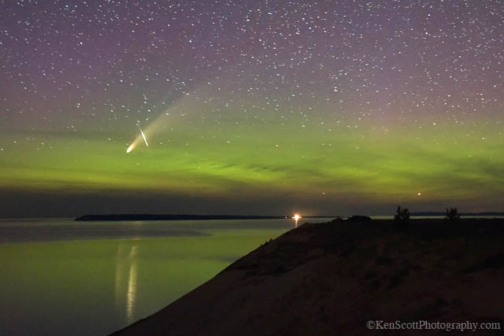
Ken was in the Sleeping Bear Dunes National Lakeshore looking towards the Manitou Islands & writes that he captured Comet Neowise, the Northern Lights and an Iridium Flare plus the bonus reflection on Lake Michigan!! The bright light to right of center horizon is the South Manitou Island Lighthouse. See it bigger on Facebook.
Here’s a beautiful scene Kevin captured back in 2015 at Grand Ravines North Park in Ottawa County. See more in his Sunrise/Sunset album & have a great day!
The river is best known for the Tahquamenon Falls, a succession of two waterfalls in Tahquamenon Falls State Park totalling approximately 73 feet (22 m) in height. Because the headwaters of the river are located in a boreal wetland that is rich in cedar, spruce and hemlock trees, the river’s waters carry a significant amount of tannin in solution (i.e., it is a blackwater river), and are often brown or golden-brown in color. The Tahquamenon Falls are thus acclaimed as being the largest naturally dyed or colored waterfall in the United States.
The meaning of “Tahquamenon” is not known. Some called it the “River of the Head Winds” because they bucked the wind on the lower river no matter what direction they were paddling. Others called it the “River of a Hundred Bends”. Twentieth century descendants of local Chippewa translated the name to mean “river up against a hill” or “lost river island” or “river with an island part way”. In 1930 Jesuit scholar, Father William Gagnieut, concluded that the meaning of the name had been lost.
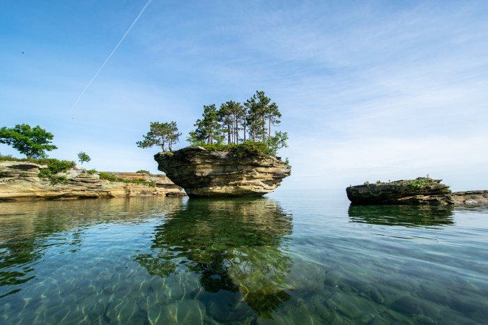
Paddling to Turnip Rock is not hard. Located at the tip of the thumb, it’s about a four hour round trip from Port Austin. This small guide offers a local point of view to avoid problems with the local law enforcement and property owners while being able to enjoy a unique natural wonder.
Despite its uniqueness, this natural wonder is located in the Pointe Aux Barques Cottage Community and is private land. Thus the only way to access it is from the water. Fortunately, that can easily be achieved by canoe or kayak. This means that you can’t go feet dry. Stay in the water. The area around the rock is monitored and even the topic of an Instagram account. If you must get out of our kayak stay as close to the water’s edge as possible. (Unless its an emergency)
During the weekends the number of paddlers can get quite large. If the area around the rock is crowded consider paddling a few hundred yards past the rock and view the overhangs and cave features that border the Pointe Aux Barques community. During the late 1800s, the cave were hideouts for fugitives. It’s worth taking a few minutes to explore. You may be tempted to get out of your kayak and climb the rocks for a view. This is a no-no and there are several signs reminding not to trespass.
Lake Michigan’s average surface water temperature has gone nearly vertical … in the past week or so. Lake Michigan now averages 74 degrees on the surface, which is 11 degrees warmer than the historical average water temperature on this date.
Lake Huron is eight degrees warmer than average at 69 degrees.
Lake Erie now is only four degrees from averaging 80 degrees. The average water temperature now is 76 degrees, with the long-term average water temperature at 70 for this date.
Lake Superior might still sound cold with an average surface water temperature of 54 degrees. The long-term historical average water temperature is 48 degrees.
I featured Cameron’s photo from Grand Traverse Bay in July of 2015, but it’s just so perfect I had to show it again. Stay cool & check out lots more pics in Cameron’s Elk Rapids, MI album on Flickr.
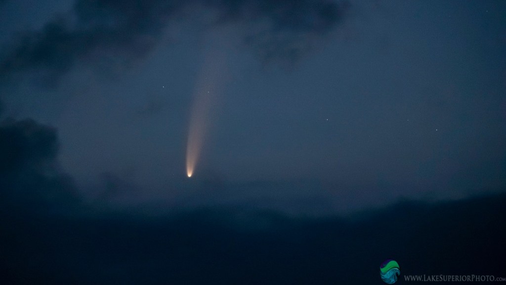
Shawn of Lake Superior Photo took this photo of Comet Neowise peeking through the clouds and fog yesterday morning. She shares that it’s visible to the naked eye & you can catch it the next few days in the northeast before sunrise!! EarthSky explains how to see Comet Neowise:
We still have to wait for another very bright comet, what astronomers call a great comet. There’s no strict definition for great comet, but most agree that Hale-Bopp – widely seen by people in 1997 – was one. Lesser comets are moderately frequent, though, and, right now, there’s a nice binocular comet in the dawn sky. Some skilled observers have reported that – once you spot it with binoculars – you can remove them and see the comet with the unaided eye. Using binoculars or other optical aid is a must, though, if you want to see this comet’s split tail. The comet is called C/2020 F3 (NEOWISE).
Comet C/2020 F3 (NEOWISE) is up at dawn now; it will be highest in the dawn sky around July 11. Then it will gradually approach the horizon each day. By mid July (around July 12-15), the comet will become visible at dusk (just after sunset), low in the northwest horizon.
If the comet remains relatively bright, it might be easier to see in the second half of July during evening dusk, because, at that time, it will appear somewhat higher in the sky.
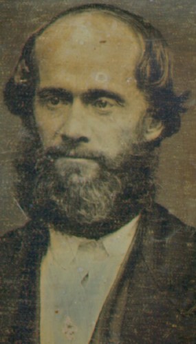
On July 8th, 1850, James Jesse Strang was crowned king of Beaver Island. Michigan History Magazine shared this article with me years ago:
Despite claiming to be “the perfect atheist,” Strang became a follower of Mormon leader Joseph Smith. When Smith was murdered in March 1844, Strang claimed to be the new Mormon leader, although most Mormons followed Brigham Young to Utah.
King James Strang (daguerreotype, 1856)
Strang’s followers settled on an uninhabited island in northern Lake Michigan they called Big Beaver. The island had everything Strang and his followers needed: virgin timber, tillable land, a deep and sheltered bay and exceptional offshore fishing. It also was twenty-five miles off the mainland-a perfect place to protect Strang’s followers from outside influences and beliefs.
By the mid-1850s, the Mormon colony on Beaver Island boasted more than 2,500 followers. Beaver Island replaced Mackinac Island as the principal refueling stop for steamers, and the annual value of the kingdom’s exports (fish, wood and potatoes) was considerable.
The growth of Strang’s kingdom was not without controversy. Non-Mormons, called Gentiles, took exception with the Mormon settlement. Driven from the area’s fishing spots, angry over the establishment of a kingdom and Strang’s adoption of the practice of polygamy, the Gentiles vowed revenge. At the bequest of President Millard Fillmore, the U.S. district attorney prosecuted Strang for an assortment of unfounded offenses that included murder and treason. However, Strang was acquitted on all charges, and a year later he was overwhelmingly elected to the state legislature.
Strang ruled Beaver Island as an autocrat; he even had himself crowned king. But regulating every aspect of his followers’ lives led to his downfall. Describing women’s clothes as impractical and unhealthy, Strang decreed female subjects needed to dress in loose, knee-length smocks worn over modest pantaloons. Most Beaver Island women accepted the change, but a few refused to comply. When two women refused to wear pantaloons, Strang had their husbands whipped. The two men sought revenge and on June 16, 1856, they ambushed and shot their king.
On July 9, 1856, James Jesse Strang died from his wounds. He was buried in Wisconsin.
With Strang gone, enraged Gentiles charged onto Beaver Island and evicted the Mormons. After taking control of the Mormon printing office, the attackers printed a manifesto that boasted, “The dominion of King Strang is at an end.”


.jpg)